MAHA TET Exam  >  MAHA TET Tests  >  MH SET Paper 2 Mock Test - 2 (Geography) - MAHA TET MCQ

MH SET Paper 2 Mock Test - 2 (Geography) - MAHA TET MCQ


Test Description

30 Questions MCQ Test - MH SET Paper 2 Mock Test - 2 (Geography)

MH SET Paper 2 Mock Test - 2 (Geography) for MAHA TET 2024 is part of MAHA TET preparation. The MH SET Paper 2 Mock Test - 2 (Geography) questions and answers have been prepared according to the MAHA TET exam syllabus.The MH SET Paper 2 Mock Test - 2 (Geography) MCQs are made for MAHA TET 2024 Exam. Find important definitions, questions, notes, meanings, examples, exercises, MCQs and online tests for MH SET Paper 2 Mock Test - 2 (Geography) below.
Solutions of MH SET Paper 2 Mock Test - 2 (Geography) questions in English are available as part of our course for MAHA TET & MH SET Paper 2 Mock Test - 2 (Geography) solutions in Hindi for MAHA TET course. Download more important topics, notes, lectures and mock test series for MAHA TET Exam by signing up for free. Attempt MH SET Paper 2 Mock Test - 2 (Geography) | 100 questions in 120 minutes | Mock test for MAHA TET preparation | Free important questions MCQ to study for MAHA TET Exam | Download free PDF with solutions
MH SET Paper 2 Mock Test - 2 (Geography) - Question 1

Mentions of the earth-science tradition are found in works of

Detailed Solution for MH SET Paper 2 Mock Test - 2 (Geography) - Question 1

The earth science tradition emerged in ancient Greece. It is seen in the works of Aristotle. He outlined the study of geography as study of natural processes in and near surface of the earth.

MH SET Paper 2 Mock Test - 2 (Geography) - Question 2

Which of the following is/are cold current/s ?

A. Peru Current

B. El Nino

C. California Current

D. Norwegian Current

Select correct answer from the codes given below :

Detailed Solution for MH SET Paper 2 Mock Test - 2 (Geography) - Question 2

The correct answer is A and C only.

Key Points

  • Ocean currents are the continuous, predictable and directional movement of seawater driven by gravity, wind and water density.
  • Ocean currents can be classified as:
    • Warm currents
    • Cold currents
  • Cold currents are ocean currents that move from polar regions towards the Equator and are cooler than the surrounding water.
  • A few cold currents are:
    • Peruvian current
    • Californial current
    • Labrador Current
    • Canary current
    • South Indian Ocean current

Thus, we can say that Peruvian and California currents are cold ocean currents.

Additional Information

  • El Nino and Norwegian currents are warm water currents.
1 Crore+ students have signed up on EduRev. Have you? Download the App
MH SET Paper 2 Mock Test - 2 (Geography) - Question 3

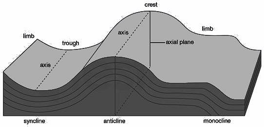
Which among the following type of folds consist of two horizontal limbs connected by a shorter inclined limb?

Detailed Solution for MH SET Paper 2 Mock Test - 2 (Geography) - Question 3

The correct answer is Monocline.

Key Points

  • Monocline
    • Monoclines are folds consisting of two horizontal (or nearly so) limbs connected by a shorter inclined limb. Hence, Option 1 is correct.
    • They can be compared to anticlines, which consist of two inclined limbs dipping away from each other, and synclines, which consist of two inclined limbs dipping towards each other.
    • Folds such as monoclines, anticlines, and synclines are defined solely based on their geometry, and the names, therefore, have no genetic connotations.
    • Monoclines are, however, characteristic of regions in which sedimentary rocks have been deformed by dip-slip movement along vertical or steeply dipping faults in older and deeper rocks, such as the Colorado Plateau of the southwestern United States.
    • Most monoclines are classified as drape folds or forced folds because the sedimentary rocks are draped or forced as a result of movement along the underlying faults.
    • Drape folds and forced folds are not necessarily monoclinal, though, so care must be taken to distinguish between geometric and genetic names.

MH SET Paper 2 Mock Test - 2 (Geography) - Question 4
Read the following statements. Which of them are true? Select your answer from the code given below:

(a) The khaddar soils are found in the low areas of valley bottom of the North Indian plains.

(b) The black regur soils are found in the Deccan plateau.

(c) The tarai region is area in the Deccan plateau.

(d) The foothills of Sahyadris have bhabar soils.

Detailed Solution for MH SET Paper 2 Mock Test - 2 (Geography) - Question 4

 The khaddar soils are pale brown, sandy clays and loams. They are found in the lower areas of valley bottoms of North Indian plains. Black regur soils made of the basaltic rock are found in the Deccan plateau. The tarai region is the area swampy lowland of the north Indian plain, just below the Himalayas is called tarai tract. The foothills of Shiwaliks have the bhabar soils.

MH SET Paper 2 Mock Test - 2 (Geography) - Question 5

Which state in India has the least percentage of Scheduled  Tribes population?

Detailed Solution for MH SET Paper 2 Mock Test - 2 (Geography) - Question 5


The state of Goa has the least percentage of Scheduled Tribes population among the states of India. The total ST population in Goa is just 566 as per the census of 2011, which accounts for 0.0% of the total population of 1,347,668.


MH SET Paper 2 Mock Test - 2 (Geography) - Question 6

Use the map below to answer the question that follows.

{{358.PNG}}

Which of the following is the main religion of the three numbered areas on the map?

Detailed Solution for MH SET Paper 2 Mock Test - 2 (Geography) - Question 6

This question requires the examinee to demonstrate knowledge of economic, cultural, and political connections within and between major world regions and places. About 97% of the people of Sudan (area 1) are Muslims. A similar or slightly higher proportion of the populations of Pakistan, Afghanistan, and Tajikistan (area 2) are also adherents of Islam, which is the main religion of Indonesia (area 3), where about 87% of the people base their faith on the teachings of Muhammad.

MH SET Paper 2 Mock Test - 2 (Geography) - Question 7
Which of the following is a minor plate of the lithosphere?
Detailed Solution for MH SET Paper 2 Mock Test - 2 (Geography) - Question 7

The correct answer is Caribbean Plate.Key Points

  • The lithosphere is divided into tectonic plates including the North American, Caribbean, South American, Scotia, Antarctic, Eurasian, Arabian, African, Indian, Philippine, Australian, Pacific, Juan de Fuca, Cocos, and Nazca
  • The Caribbean Plate is a mostly oceanic tectonic plate underlying Central America and the Caribbean Sea off the north coast of South America. It is a minor plate.

Additional Information

  • The names of the minor plates are the Scotia plate, the Nazca plate, the Cocos plate, the Caribbean plate, the Juan de Fuca, the Arabian plate, and lastly the Philippine plate.
  • The Eurasian Plate is a tectonic plate that includes most of the continent of Eurasia, with the notable exceptions of the Indian subcontinent, the Arabian subcontinent, and the area east of the Chersky Range in eastern Siberia.
  • The Antarctic Plate is a tectonic plate containing the continent of Antarctica, the Kerguelen Plateau, and some remote islands in the Southern Ocean and other surrounding oceans.
  • The Indo-Australian Plate is a major tectonic plate that includes the continent of Australia and the surrounding ocean and extends northwest to include the Indian subcontinent and the adjacent waters. It was formed by the fusion of the Indian and the Australian Plates approximately 43 million years ago.

Thus, Caribbean Plate is a minor plate of the lithosphere.

MH SET Paper 2 Mock Test - 2 (Geography) - Question 8

Consider the following statements regarding the distribution of pressure belts in the globe:

1. The sub-polar low belts are thermally induced and the temperature contrast between the subtropical and the polar regions gives rise to cyclonic storms here.

2. Only vertical currents are experienced in the equatorial low belt.

3. Calm conditions with feeble and variable winds are found in the subtropical high belt.

Which of the above statements is/are correct?
Detailed Solution for MH SET Paper 2 Mock Test - 2 (Geography) - Question 8

Equatorial low pressure belt:

  • Near the equator the sea level pressure is low and the area is known as equatorial low.
  • This belt is thermally produced due to heating by the sun. Due to excessive heating horizontal movement of air is absent here and only vertical currents are experienced in this belt.
  • Therefore, this belt is called doldrums (the zone of calm).
  • This belt is also known as Inter Tropical Convergence Zone (ITCZ) because the trade winds flowing from the subtropical high pressure belts converge here.


Subtropical high pressure belt:

  • Along 30° N and 30°S are found the high-pressure areas known as the subtropical highs.
  • The existence of these pressure belts is due to the fact that the rising air of the equatorial region is deflected towards poles due to the earth’s rotation.
  • After becoming cold and heavy, it descends in these regions and results in high pressure.
  • Calm conditions with feeble and variable winds are found here.
  • In the southern hemisphere, this belt is broken by small low-pressure areas in summer over Australia and South Africa.
  • In the northern hemisphere, the belt is more discontinuous by the presence of land masses, and high pressure occurs only over the ocean areas as discrete cells; these are termed the Azores and Hawaiian cells in the Atlantic and Pacific areas respectively.
  • These belts are also called Horse latitudes. In older days, vessels with cargo of horses passing through these belts found difficulty in sailing under these calm conditions. They used to throw the horses in the sea in order to make the vessels lighter.
  • In the upper atmosphere over this belt the upper level westerlies and anti-trade winds converge and set up descending currents in the atmosphere.


Sub-polar low pressure belt:

  • Further polewards along 60°N and 60°S, the low-pressure belts are termed as the subpolar lows.
  • These belts are not thermally induced; instead the winds coming from the subtropics and the polar regions converge in this belt and rise upward.
  • The great temperature contrast between the subtropical and the polar regions, gives rise to cyclonic storms in this belt.
  • In the southern hemisphere, this low pressure belt is more pronounced due to the vast presence of ocean and is referred to as the sub-antarctic low.
  • But in the northern hemisphere, there are large land masses which are very cold. Therefore, the pressure over these landmasses are increased and the continuity of the belt is broken.
MH SET Paper 2 Mock Test - 2 (Geography) - Question 9
Which one of the following assumptions in Von Thunen’s model of agriculture land use is not true?
Detailed Solution for MH SET Paper 2 Mock Test - 2 (Geography) - Question 9

Johann Heinrich Von Thunen developed a crop theory in 1826 in which he took various assumptions like an isolated estate, isotropic surface, uniform price for a crop in the market and there would be only one market for one agricultural area where the surplus of the agricultural area will be sold.

MH SET Paper 2 Mock Test - 2 (Geography) - Question 10

Which state is the largest producer of wheat in India ?

Detailed Solution for MH SET Paper 2 Mock Test - 2 (Geography) - Question 10

Uttar Pradesh is the largest Wheat producing state of India, followed by Punjab, Haryana and Madhya Pradesh.

MH SET Paper 2 Mock Test - 2 (Geography) - Question 11

Directions: The following seven (7) items consist of two statements, Statement I and Statement II. Examine these two statements carefully and select the correct answer using the code given below.

Statement I: Tides are the rise and fall of sea levels caused by the combined effects of the gravitational forces exerted by the Moon and the Sun and the rotation of the Earth.

Statement II: The Earth rotates from west to east.

Detailed Solution for MH SET Paper 2 Mock Test - 2 (Geography) - Question 11

Both the statements are individually true, but Statement II is not the correct explanation of Statement I.

Key Points

  • Statement 1- Tides are the rise and fall of the levels of the ocean. Tides are caused by the gravitational pull of the Sun and Moon as well as the rotation of the Earth.
  • Statement 2- The direction of rotation of Earth is from West to East or left to right.


Important Points

  • The periodical rise and fall of the sea level, once or twice a day, mainly due to the attraction of the sun and the moon, is called a tide.
  • The movement of water caused by meteorological effects (winds and atmospheric pressure changes) are called surges.
  • Surges are not regular like tides. The study of tides is very complex, spatially and temporally, as it has great variations in frequency, magnitude and height.
  • The moon’s gravitational pull to a great extent and to a lesser extent the sun’s gravitational pull, are the major causes for the occurrence of tides.
  • Another factor is centrifugal force, which is the force that acts to counterbalance gravity. Together, the gravitational pull and the centrifugal force are responsible for creating the two major tidal bulges on the earth.
  • The shape of bays and estuaries along a coastline can also magnify the intensity of tides. Funnel-shaped bays greatly change tidal magnitudes. When the tide is channelled between islands or into bays and estuaries they are called tidal currents.
MH SET Paper 2 Mock Test - 2 (Geography) - Question 12
Match List-I with List-II

Code:

Detailed Solution for MH SET Paper 2 Mock Test - 2 (Geography) - Question 12

  • 21st March is the day of equinox. The sun is directly above the equator. The equinox also occurs on 23rd September. The day and night last12 hours each on these days.
  • 1st June is the day that is expected arrival of monsoon in India. Though this just expected date, usually monsoon arrives later.
  • 22nd Dec is winter solstice. This is supposed to be the longest night. On this day, the sun is overhead at the tropic of Capricorn.
  • 21st June the day of longest summer solstice. The sun is overhead the tropic of cancer on the day of summer solstice.

Thus, the correct answer is A.

MH SET Paper 2 Mock Test - 2 (Geography) - Question 13
Consider the following statements about Losch’s theory of industrial location and choose which amongst them is true:

i. Goods have high demand with low prices.

ii. The demand curve rotated round the production point to give shape.

iii. As the competition increases, the market areas becomes hexagonal.

Detailed Solution for MH SET Paper 2 Mock Test - 2 (Geography) - Question 13

Losch’s theory attempts to explain the size and shape of market area within which a location would command the largest revenue. It is assumed that the demand varies inversely with price. This gives us a demand pattern. The demand curve can be rotated round the production point to give the size and shape of the market space. With increasing competition, the size of the market area becomes hexagonal. They also become smaller as the markets are competed away.

Thus, the Correct answer is D.

MH SET Paper 2 Mock Test - 2 (Geography) - Question 14
Consider the following statement about trade and growth and state which of them is true?

i. In the last century, the world economy has experienced positive economic growth.

ii. There is a visible direct relationship between the GDP and the trade growth.

Detailed Solution for MH SET Paper 2 Mock Test - 2 (Geography) - Question 14

Over the last couple of centuries, the world economy has experienced sustained positive economic growth, and over the same period , this process of economic growth has been accompanied by even faster growth in global trade. Also the country level data has a positive correlation between GDP and trade growth.

MH SET Paper 2 Mock Test - 2 (Geography) - Question 15
Cloudy nights are warmer than clear nights because
Detailed Solution for MH SET Paper 2 Mock Test - 2 (Geography) - Question 15

The correct answer is it acts as a hindrance to terrestrial radiation.

Key Points

  • Cloudy nights are warmer compared to clear cloudless nights, because clouds Reflect back the heat given off by earth.
  • The cloudy skies are like a blanket and the warmer air on the ground with us tries to leave and the clouds stop it from leaving.
  • Warmer air will always try to move up and it cannot do so because of the clouds. That's why you might notice that cloudy nights are warmer than clear nights.
  • If skies are clear, heat emitted from the earth\'s surface freely escapes into space, resulting in colder temperatures.
MH SET Paper 2 Mock Test - 2 (Geography) - Question 16

Match List I with List II and select the correct answer using the code given below the Lists :
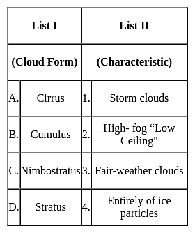
Detailed Solution for MH SET Paper 2 Mock Test - 2 (Geography) - Question 16

The correct answer is option 3.

Key Points

  • Cirrus clouds
    • Formed at high altitudes (8,000 - 12,000m). 
    • They are thin and detached clouds having a feathery appearance.
    • They are always white in color.
    • Cirrus clouds are delicate, feathery clouds that are made mostly of ice crystals.
    • Their wispy shape comes from wind currents which twist and spread the ice crystals into strands.
  • Cumulus
    • ​Formed at a height of 4,000 - 7,000 m.
    • They can appear as low as 300ft above the ground.
    • They exist in patches and can be seen scattered here and there.
    • These clouds look like fluffy, white cotton balls in the sky. They have a flat base
  • Nimbostratus
    • Nimbus is known as a rainstorm within the Latin language.
    • Low-level Clouds, resulting from thickening Altostratus.
    • These are dark, gray clouds that seem to fade into falling rain or snow.
    • They are so thick that they often blot out the sunlight.
  • Stratus
    • These are low Clouds (less than 6,500 feet).
    • These are layered clouds covering large portions of the sky. 
    • Stratus clouds often look like thin, white sheets covering the whole sky. Since they are so thin, they seldom produce much rain or snow.
    • Sometimes, in the mountains or hills, these clouds appear to be fog.

​​Hence, the correct answer is option 3.

MH SET Paper 2 Mock Test - 2 (Geography) - Question 17

Consider the following departments/ministries:

  1. Ministry of Personnel, Public Grievances and Pensions
  2. Department of Atomic Energy
  3. Department of Space

Which of the above is/are under the direct charge of the Prime Minister of India?

Detailed Solution for MH SET Paper 2 Mock Test - 2 (Geography) - Question 17

All the above mentioned departments/ministries are under the direct charge of the Prime Minister. 

MH SET Paper 2 Mock Test - 2 (Geography) - Question 18

How the soil erosion can be prevented?

Detailed Solution for MH SET Paper 2 Mock Test - 2 (Geography) - Question 18

The four most common soil erosion prevention methods are vegetation, geotextiles, mulch, and retaining walls. The simplest and most natural way to prevent erosion is through planting vegetation. Plants establish root systems, which stabilizes soil and prevents soil erosion.

MH SET Paper 2 Mock Test - 2 (Geography) - Question 19
Which type of soil is predomainantly found in the Deccan lava tract in India?
Detailed Solution for MH SET Paper 2 Mock Test - 2 (Geography) - Question 19

The correct answer is Black Soil.

Key Points

  • Black Soil is predomainantly found in the Deccan lava tract in India.
  • On the Deccan lava plateau and the Malwa Plateau, where there is moderate rainfall and underlying basaltic rock, black soils, which are derivatives of trap lava, are mostly found in interior Gujarat, Maharashtra, Karnataka, and Madhya Pradesh.
  • Black soils have a high percentage of clay, which causes large fissures to form during the dry season, yet their iron-rich granular structure prevents wind and water erosion.
  • Despite having little humus, they are very moisture-retentive and react well to irrigation.
  • These soils can also be found on several outlying tracts where river processes have caused the underlying basalt to be moved from its original position.

Important Points

  • Alluvium is loose clay, silt, sand, or gravel that has been deposited by flowing water on a stream bed, on a floodplain, in an alluvial fan or beach, or in environments that are similar.
  • About 13% of the soils on Earth are red soil, which often forms in warm, moderate, and humid areas.
  • Heavy rainfall, periods of wet and dry weather, and high temperatures all contribute to the formation of laterite soil, which is then primarily composed of iron and aluminium oxides once the soil has been leached.
MH SET Paper 2 Mock Test - 2 (Geography) - Question 20

For cotton cultivation which among the following soils is considered most suitable?

Detailed Solution for MH SET Paper 2 Mock Test - 2 (Geography) - Question 20

For cotton cultivation Black Soil is considered most suitable.

Thus, the correct answer is B.

MH SET Paper 2 Mock Test - 2 (Geography) - Question 21

A geographer is analyzing global trade routes in the era of sailing ships. Which of the following two essential elements of geography would likely form the conceptual bases of the geographer's study?

Detailed Solution for MH SET Paper 2 Mock Test - 2 (Geography) - Question 21

This question requires the examinee to demonstrate knowledge of the six essential elements of geography (i.e., the world in spatial terms, places and regions, physical systems, human systems, human-environment interactions, and the uses of geography). Analyzing global trade routes in the era of sailing ships requires an understanding of the patterns and networks of economic interdependence across Earth's surface. Such networks are a major feature of the essential geographic element of human systems. An examination of global trade routes during this period also involves an analysis of the world in spatial terms, the relationships across space between people, places, and environments.

MH SET Paper 2 Mock Test - 2 (Geography) - Question 22
The thickness of the Troposphere is maximum at the Equator during which of the following seasons?
Detailed Solution for MH SET Paper 2 Mock Test - 2 (Geography) - Question 22

The correct answer is Summer.

Key Points

  • The Troposphere is the lowest layer of the atmosphere.
  • It extends up to an height of 20 km.
  • The height of the Troposphere varies from the equator to the poles.
  • its height varies with latitude and seasons.
  • Its height is lower in the winter and highest in the summer.
  • It can be as high as 20 km near the Equator and as low as 7 km at the poles.
  • Therefore, the thickness of the Troposphere is maximum at the Equator during summer season.

 Thus, we can say that the thickness of the Troposphere is maximum at the Equator.

MH SET Paper 2 Mock Test - 2 (Geography) - Question 23

Consider the following statements regarding Census-2011:

1. The percentage decadal growth of population during 2001-2011 has registered the sharpest decline since independence.

2. It created the National Population Register (NPR) which will build up a comprehensive identity database of usual residents of the country.

3. Census 2011 was conducted in two phases - the house listing phase and the population enumeration phase.

Which of the above statements is/are correct?
Detailed Solution for MH SET Paper 2 Mock Test - 2 (Geography) - Question 23
  • Census 2011 was conducted in two phases:
  1. The first phase, called the House Listing or Housing Census was conducted between April and September, 2010 across the country, depending on the convenience of different States/UTs.
  2. The second phase, called the Population Enumeration, began simultaneously all over the country from February 9, 2011 and continued up to February 28, 2011.
  • The landmark of Census 2011 is the creation of the National Population Register (NPR) which will build up a comprehensive identity database of usual residents of the country. It will have the biometric data and Unique Identification (UID) number of every person (15 years and above).
  • National Identity Cards will be given in a phased manner to all usual residents by the Office of the Registrar General and Census Commissioner, India.
  • India's population as on 1 March 2011 stood at 1,210,193,422 (623.7 million males and 586.4 million females) in comparison to a total of 1, 028, 737, 436 in the year 2001. In absolute terms, the population of India has increased by more than 181 million during the decade 2001-2011.
  • The percentage decadal growth of population during 2001-2011 has registered the sharpest decline since independence. It declined from 23.87 per cent for 1981-1991 to 21. 54 per cent for the period 1991-2001, a decrease of 2.33 per cent. For 2001-2011, decadal growth has become 17.64 per cent, a further decrease of 3.90 percentage point.
MH SET Paper 2 Mock Test - 2 (Geography) - Question 24
Given below are two statements- one is labelled as Assertion (A) and the other is labelled as Reason (R):

Assertion(A)- Wegener was of the view that western and eastern coastlines of the Atlantic Ocean are in Jig-saw fit.

Reason(R)- The Continental drift theory was based primarily on two premises, which were polar wandering and matching of geological formations.

Choose the correct option:

Detailed Solution for MH SET Paper 2 Mock Test - 2 (Geography) - Question 24

Alfred Wegener based his theory of the basis of the following premises. Firstly, the geological formations and fossil remains of the present far away continents showed similarities. Secondly, some of the continents showed complementary coastlines, such as the East coast of South America matches the West coast of Africa. Polar Wandering or Paleomagnetism and geological matching are some of the evidences which were cited by Wegener to show that the continents were close once.

MH SET Paper 2 Mock Test - 2 (Geography) - Question 25

Which of the following statement is correct about weathering?

Detailed Solution for MH SET Paper 2 Mock Test - 2 (Geography) - Question 25

The correct answer is option 1.

Key Points

  • Weathering:
    • Weathering is the disintegration of rocks, soil, and minerals under the influence of physical (heat, pressure) and chemical (leaching, oxidation and reduction, hydration) agents.
    • As very little or no motion of materials takes place in weathering, it is an in-situ or on-site process.
    • The weathered material is carried farther away by erosion.
      There are three major groups of weathering processes: 1) chemical; 2) physical or mechanical; 3) biological weathering processes. All the types of weathering often go hand in hand.
    • Weathering due to dissolution, solution, carbonation, hydration, oxidation, and reduction that act on the rocks is termed chemical weathering. Hence, statement 3 is incorrect.
    • Expansion of solids due to temperature change, hydration, and crystallization is referred to as physical weathering. Hence, statement 1 is correct
    • The reason behind exhalation sheets is unloading and pressure release
    • Biological weathering is the removal of minerals from the environment due to the growth or action of organisms. Hence, statement 2 is incorrect.
MH SET Paper 2 Mock Test - 2 (Geography) - Question 26
Which of the following statements are true about Von Thunen’s model of regional land use?

(a) It is assumed that the land near the market is flat and has uniform fertility.

(b) Livestock farming is done in areas nearest to the marketplace.

(c) There are multiple markets available for sale of local produce.

(d) The cost of the land increases as its distance from the marketplace increases.

Code:

Detailed Solution for MH SET Paper 2 Mock Test - 2 (Geography) - Question 26

Johann Heinrich von Thunen gave the agricultural land use model in early 1800s. The model contained four zones of concentric circles depicting land use around the marketplace. The assumptions of the theory are:- (i)There is only one common central market where all the produce is sold. (ii)The land is isolated, flat with uniform fertility and climate. (iii) Everyone has access to transport and farmers behave with economic rationality. The first zone, nearest to marketplace was of dairy farming, followed by forest, grains and field crops and livestock farming and ranching. As we go away from the central market, the cost of land decreases.

Thus, the correct answer is C.

MH SET Paper 2 Mock Test - 2 (Geography) - Question 27
Which of the following statements is NOT correct regarding the rabi crops?
Detailed Solution for MH SET Paper 2 Mock Test - 2 (Geography) - Question 27

The correct answer is Southern and southeastern states are important for the production of wheat and other rabi crops.

Key Points

  • Punjab, Haryana, Uttar Pradesh, and Madhya Pradesh, are major contributors to the production of wheat, barley, and other rabi crops. Hence Option 1 is incorrect.
  • These regions have favorable climatic conditions and fertile soil, making them suitable for the cultivation of rabi crops.
  • Wheat is one of the most important rabi crops grown in these states, and they significantly contribute to the overall wheat production in the country.
  • Other rabi crops like barley, peas, gram, and mustard are also cultivated in these regions.

Additional Information

  • Kharif crops
    • Kharif Crops are planted at the onset of the South-West monsoon, primarily in India, Pakistan, and Bangladesh, during the rainy season.
    • The sowing of these crops takes place between the months of June and July.
    • Upon reaching maturity, typically in October, these crops are harvested in the Autumn season.
    • Examples of Kharif crops include rice, cotton, corn, sugarcane, turmeric, pigeon pea, and more.
  • Zaid crops
    • Zaid Crops are grown during the summer season in regions with a tropical climate.
    • These crops are typically cultivated between the months of March and June.
    • Zaid crops are known for their quick growth and shorter duration compared to Kharif and Rabi crops.
    • Examples of Zaid crops include cucumber, watermelon, bitter gourd, maize, and cowpea.
    • These crops are often irrigated using modern techniques and are harvested before the onset of the monsoon season.
MH SET Paper 2 Mock Test - 2 (Geography) - Question 28
Consider the following statement:

i. Air mass thunderstorm occur as a result of vertical displacement of air mass within an air mass.

ii. Local heat thunderstorm is a type of air mass thunderstorm

Choose the correct answer:

Detailed Solution for MH SET Paper 2 Mock Test - 2 (Geography) - Question 28

Air mass thunderstorm occur as a result of vertical displacement of air within an air mass and are not connected with frontal effects. Included in this type are the local heat thunderstorm, Orographic thunderstorm and advective or upper thunderstorm.

Thus, the Correct answer is C .

MH SET Paper 2 Mock Test - 2 (Geography) - Question 29
Consider the following statements:-

a) Sea level Changes are only affected by Eustatic changes.

b) Marine sediments depict about global sea level change.

c) Evidences of sedimentary deposits of various sorts depict sea level changes during the pre-quaternary stages.

d) Sea level has risen by about 10 to 16 cm in the past 100 years.

Which of the following statements is correct?

Detailed Solution for MH SET Paper 2 Mock Test - 2 (Geography) - Question 29

The sea level changes are not only affected by eustatic changes such as the melting of ice and global warming but also by tectonic changes such as Isostatic changes, epeirogenetic and orogenetic changes. Various other evidences such as elevated shorelines, the deposition of organic and inorganic deposits in the continental shelves support the sea level changes. But recently, the change in the sea level has mostly been due to the factors such as global warming due to anthropogenic conditions and melting of glaciers and ice sheets.

MH SET Paper 2 Mock Test - 2 (Geography) - Question 30

In an ecotone, the species which become abundant are called:

Detailed Solution for MH SET Paper 2 Mock Test - 2 (Geography) - Question 30

An ecotone is a transition area between two biomes but different patches of the landscape, such as forest and grassland. The ecotone contains not only species common to the communities on both sides; it may also include a number of highly adaptable species that tend to colonize such transitional areas. This can produce an edge effect along the boundary line, with the area displaying a greater than usual diversity of species. The phenomenon of increased variety of plants as well as animals at the community junction is called the “edge effect” and is essentially due to a locally broader range of suitable environmental conditions or ecological niches.

View more questions
Information about MH SET Paper 2 Mock Test - 2 (Geography) Page
In this test you can find the Exam questions for MH SET Paper 2 Mock Test - 2 (Geography) solved & explained in the simplest way possible. Besides giving Questions and answers for MH SET Paper 2 Mock Test - 2 (Geography), EduRev gives you an ample number of Online tests for practice

Top Courses for MAHA TET

Download as PDF

Top Courses for MAHA TET