MAHA TET Exam  >  MAHA TET Tests  >  MH SET Paper 2 Mock Test - 7 (Geography) - MAHA TET MCQ

MH SET Paper 2 Mock Test - 7 (Geography) - MAHA TET MCQ


Test Description

30 Questions MCQ Test - MH SET Paper 2 Mock Test - 7 (Geography)

MH SET Paper 2 Mock Test - 7 (Geography) for MAHA TET 2024 is part of MAHA TET preparation. The MH SET Paper 2 Mock Test - 7 (Geography) questions and answers have been prepared according to the MAHA TET exam syllabus.The MH SET Paper 2 Mock Test - 7 (Geography) MCQs are made for MAHA TET 2024 Exam. Find important definitions, questions, notes, meanings, examples, exercises, MCQs and online tests for MH SET Paper 2 Mock Test - 7 (Geography) below.
Solutions of MH SET Paper 2 Mock Test - 7 (Geography) questions in English are available as part of our course for MAHA TET & MH SET Paper 2 Mock Test - 7 (Geography) solutions in Hindi for MAHA TET course. Download more important topics, notes, lectures and mock test series for MAHA TET Exam by signing up for free. Attempt MH SET Paper 2 Mock Test - 7 (Geography) | 100 questions in 120 minutes | Mock test for MAHA TET preparation | Free important questions MCQ to study for MAHA TET Exam | Download free PDF with solutions
MH SET Paper 2 Mock Test - 7 (Geography) - Question 1

La Terre is authored by whom of the following?

Detailed Solution for MH SET Paper 2 Mock Test - 7 (Geography) - Question 1

Correct Answer: Reclus.

Key Points

  • Élisée Reclus, French geographer and anarchist who was awarded the gold medal of the Paris Geographical Society in 1892 for La Nouvelle Géographie universelle.
  • He was educated at the Protestant college of Montauban and studied geography under Carl Ritter in Berlin. Having identified himself with the republicans of 1848, he was obliged to leave France after the coup d’etat of 1851. He spent the years 1852–57 visiting the British Isles, the United States, Central America, and Colombia.
  • Returning to France, he applied himself to geography, publishing La Terre, description des phénomènes de la vie du globe, 2 vol. (1867–68; The Earth: A Descriptive History of the Phenomena of the Life of the Globe, 4 vol., 1871–73) and Histoire d’un ruisseau (1869; “History of a Brook”). 
  • His great work, La Nouvelle Géographie universelle, la terre et les hommes, 19 vol. (1875–94; The Earth and Its Inhabitants, 1878–94), is profusely illustrated with maps, plans, and engravings and characterized by a brilliance of exposition that gives his work permanent scientific value.

​ Additional Information

  • ​Pyotr Alexeyevich Kropotkin was a Russian anarchist, socialist, revolutionary, historian, scientist, philosopher, and activist who advocated anarcho-communism. Kropotkin was a proponent of a decentralized communist society free from central government and based on voluntary associations of self-governing communities and worker-run enterprises.
  • Thomas Henry Huxley proposed connections between the development of organisms and their evolutionary histories, critiqued previously held concepts of homology, and promoted Charles Darwin's theory of evolution. Many called him Darwin's Bulldog. 
MH SET Paper 2 Mock Test - 7 (Geography) - Question 2

______ is an Indian crewed orbital spacecraft of ISRO.

Detailed Solution for MH SET Paper 2 Mock Test - 7 (Geography) - Question 2

Gaganyan is an Indian crewed orbital spacecraft of ISRO.

Key PointsGaganyan:

  • Gaganyaan is an Indian crewed orbital spacecraft intended to be the formative spacecraft of the Indian Human Spaceflight Programme.
  • The spacecraft is being designed to carry three people, and a planned upgraded version will be equipped with rendezvous and docking capability.
  • In its maiden crewed mission, Indian Space Research Organisation (ISRO)'s largely autonomous 5.3 t (12,000 lb) capsule will orbit the Earth at 400 km (250 mi) altitude for up to seven days with a two or three-person crew on board.
  • The first crewed mission was originally planned to be launched on ISRO's GSLV Mk III in December 2021, but this has since been delayed to no earlier than 2023.
  • This Hindustan Aeronautics Limited (HAL) manufactured crew module had its first un-crewed experimental flight on 18 December 2014.
  • As of May 2019, design of the crew module has been completed.
  • Defence Research and Development Organisation (DRDO) will provide support for critical human-centric systems and technologies like space grade food, crew healthcare, radiation measurement and protection, parachutes for the safe recovery of the crew module and fire suppression system.
  • On 11 June 2020, it was announced that while the first uncrewed Gaganyaan launch has been delayed due to COVID-19 pandemic in India, overall timeline for crewed launches is expected to remain unaffected.

Hence, Gaganyan is the correct answer.

1 Crore+ students have signed up on EduRev. Have you? Download the App
MH SET Paper 2 Mock Test - 7 (Geography) - Question 3

Given below are two statements. One is labelled as Assertion (A) and the other is labelled as Reason (R).

Assertion (A): Anti-cyclone leads to violent thunderstorms.

Reason (R): Anti-cyclones have high pressure at its centre.

Select the correct answer from options given below:

Detailed Solution for MH SET Paper 2 Mock Test - 7 (Geography) - Question 3

Anti-cyclones are circular patterns of air movement. It has a high-pressure cell at its centre. Anti-cyclones are generally associated with calm weather. They show persistent and yield dry air. Cyclones are generally accompanied with violent thunderstorms. Thus, (A) is false and (R) is true.

Thus, the correct answer is D.

MH SET Paper 2 Mock Test - 7 (Geography) - Question 4
Patkai hills, and the Naga hills are part of
Detailed Solution for MH SET Paper 2 Mock Test - 7 (Geography) - Question 4

The correct answer is Purvachal hills.

Key Points

  • The Purvanchal Range, or Eastern Mountains, is a sub-mountain range of the Himalayas in North-East India.
  • The Purvanchal comprises :
    • The Patkai Hills
    • The Naga Hills
    • Manipur Hills
    • The Mizo Hills
  • The Patkai Hills:
    • The Patkai Hills are the hills on India's north-eastern border with Burma or Myanmar.
  • The Naga Hills:
    • The Naga Hills lies on the border of India and Burma.
  • The Mizo Hills:
    • Mizo Hills is a mountain range in southeastern Mizoram state.
    • Mizo Hills form part of the north Arakan Yoma system.
  • The range is an eastern extension of the Himalayan Range System, in northeastern India.
  • It bends sharply to the south beyond the Dihang River gorge and spreads along the eastern boundary of India with Myanmar. 
  • The Purvanchal includes the hill of the Patkai hills, Naga Hills, Mizo Hills, and Manipur hills.

Hence, the correct answer is Purvachal hills.

MH SET Paper 2 Mock Test - 7 (Geography) - Question 5

Statements (A) and (B) are the main features of which of the following continents?

(A) The Continent is bound by oceans and seas on all sides.

(B) Tropic of Cancer, The Equator and Tropic of Capricorn pass through this continent.

Detailed Solution for MH SET Paper 2 Mock Test - 7 (Geography) - Question 5

The correct answer is Africa.

Key Points

  • The correct answer is Option 4 in Africa, which is the correct answer because it is the only continent bound by oceans and seas on all sides, and the Tropic of Cancer, Equator, and Tropic of Capricorn all pass through it.

  • African Countries on the Tropic of Cancer - Western Sahara, Niger, Algeria, Mauritania, Egypt, Libya, and Mali.
  • African countries on the Equator - Gabon, Congo, Democratic Republic of Congo, Uganda, Kenya, Sao Tome and Principe, and Somalia
  • African Countries on the Tropic of Capricorn - Namibia, Botswana, South Africa, Mozambique, and Madagascar

Additional Information

  • Asia is the largest continent in terms of land area and population.
  • Australia is the smallest continent in terms of land area and is also the world's smallest continent in terms of population.
  • South America is the fourth largest continent in terms of land area and the fifth most populous continent in the world.
MH SET Paper 2 Mock Test - 7 (Geography) - Question 6

In the history of India population, which duration period is referred to as 'A great leap forward'?

Detailed Solution for MH SET Paper 2 Mock Test - 7 (Geography) - Question 6

A great leap forward' in context of Indian population census in considered the decadal growth from 1951 to 1961.

MH SET Paper 2 Mock Test - 7 (Geography) - Question 7
Consider the following statements about rectangular drainage pattern:

a. Generally results from the presence of joints and fractures

b. The arrangement of the channels is such that the principal tributary streams are parallel and very long.

c. Common in areas with parallel fractures or faults.

d. Characterised by right-angle bends.

Which of the above statements are correct?

Detailed Solution for MH SET Paper 2 Mock Test - 7 (Geography) - Question 7

Rectangular streams are channel systems marked by right-angle bends and generally results from the presence of joints and fractures in massive rocks or foliation in metamorphic rocks. Such structures with their cross-cutting patterns have guided the directions of valleys.

The other two options depict a trellis pattern.

MH SET Paper 2 Mock Test - 7 (Geography) - Question 8

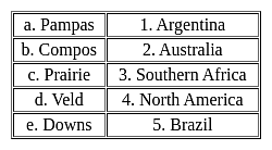
Match the following -

Detailed Solution for MH SET Paper 2 Mock Test - 7 (Geography) - Question 8

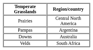
Important PointsTemperate Grasslands:

  • Temperatures vary much more in temperate grasslands than they do in savannas.
  • Savannas are in warm climates with average annual temperatures that only vary between 21 and 26 degrees Celsius (70 and 78 degrees Fahrenheit).
  • They typically have only two seasons, a wet and a dry season.
  • Temperate grasslands have hot summers where temperature can exceed 38 degrees Celsius (100 degrees Fahrenheit) and cold winters that can drop below negative 40 degrees Celsius (negative 40 degrees Fahrenheit).

Key Points


Hence, the correct matching is a - 1, b - 5, c - 4, d - 3, e - 2

MH SET Paper 2 Mock Test - 7 (Geography) - Question 9

Consider the following statements:

1. Biogas is produced from the breakdown of Organic Matter by Viruses.

2. Distillation Process is used to refine Crude Oil into numerous products.

3. China is the largest producer of bauxite in the world.

Which of the statements given above are incorrect?

Detailed Solution for MH SET Paper 2 Mock Test - 7 (Geography) - Question 9

The correct answer is 1 and 3 only.Key Points Biogas

  • Biogas is a mixture of methane and carbon dioxide.
  • Biogas is an environmentally-friendly, renewable energy source.
  • It's produced when organic matter, such as food or animal waste, is broken down by microorganisms in the absence of oxygen, in a process called Anaerobic Digestion. Hence, statement 1 is incorrect.

Petroleum

  • Petroleum and its derivatives are called Black Gold as they are very valuable.
  • Petroleum, also called crude oil, is a naturally occurring liquid found beneath the earth’s surface that can be refined into fuel.
  • A fossil fuel, petroleum is created by the decomposition of organic matter over time.
  • The crude oil is refined and separated, most easily by distillation, into numerous products for direct use or use in manufacturing. Hence, statement 2 is correct.
  • Products include fuels such as:
    • Gasoline (petrol), diesel, kerosene, asphalt, chemical reagents used to make plastics, pesticides and pharmaceuticals.

Bauxite

  • Bauxite is a naturally occurring heterogeneous material composed primarily of one or more aluminium hydroxide minerals.
  • Australia is the world's largest bauxite producer, producing almost a third of global bauxite. Hence, statement 3 is incorrect.
  • Bauxite is mined in Australia using open-cut mining, which suits the relatively shallow bauxite deposits located mostly in Western Australia and Queensland.

Additional Information Formation of Fossil Fuel:

  • Millions of years ago, algae and plants lived in shallow seas.
  • After dying and sinking to the seafloor, the organic material mixed with other sediments and was buried.
  • Over millions of years under high pressure and high temperature:
    • The remains of these organisms transformed into fossil fuels.
    • Coal, natural gas, petroleum and are all fossil fuels that formed under similar conditions.
MH SET Paper 2 Mock Test - 7 (Geography) - Question 10

"Maps are the graphic representations of the surface of the earth" who stated that

Detailed Solution for MH SET Paper 2 Mock Test - 7 (Geography) - Question 10

"Maps are the graphic representations of the surface of the earth" Finch and Trewartha stated that.

MH SET Paper 2 Mock Test - 7 (Geography) - Question 11

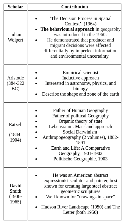
Which one of the following pairs is NOT matched correctly?

Detailed Solution for MH SET Paper 2 Mock Test - 7 (Geography) - Question 11

David Smith : Marxist perspective is NOT matched correctly
Important Point

MH SET Paper 2 Mock Test - 7 (Geography) - Question 12
Whose work is “the study of social geography”?
Detailed Solution for MH SET Paper 2 Mock Test - 7 (Geography) - Question 12

George Wilson Hoke was the first person to use the term social geography. He published his paper titled “ the study of social geography”. It was published in the year 1907

Thus, the Correct answer is A.

MH SET Paper 2 Mock Test - 7 (Geography) - Question 13
Which of the following is measured on Richter's scale?
Detailed Solution for MH SET Paper 2 Mock Test - 7 (Geography) - Question 13

The Correct Answer is the Intensity of earthquakes

Key Points

  • The Intensity of the earthquake is measured on the Richter scale
  • Charles F. Richter developed the Richter Scale in 1935.
  • It is measured using a machine called a seismometer which produces a seismograph. A Richter scale is normally numbered 1-10, though there is no upper limit.
  • This information comes from seismographs, which collect data and directly measure the amount of ground shaking.

Additional Information

  • An earthquake is known as a quake, tremor, or temblor. It is ​a sudden release of energy in the Earth's lithosphere that creates seismic waves.
  • There are three types of earthquake waves:
    • P waves or longitudinal waves
    • S waves or transverse waves
    • L waves or surface waves
MH SET Paper 2 Mock Test - 7 (Geography) - Question 14
Consider the following statements and state which of them is true about the types of maps-

(i). Political maps show the geographical boundaries between countries, states, districts etc.

(ii). Physical maps have green to brown and grey colour scheme for showing elevation.

(iii). Shallow water body is shown with light blue colour

(iv). Cities and roads are not shown in physical map

Detailed Solution for MH SET Paper 2 Mock Test - 7 (Geography) - Question 14

Physical maps are used to show the natural landscape feature of the earth. They use either colours or shades to show relief. They use green, brown and grey colours to show land elevation, dark green for near sea elevation. Shades of grey is used for highest elevation. Water bodies are often shades of blue. Glaciers and ice caps shown with white.

Political maps are used to show geographical boundaries of government units like countries, states, districts, cities etc. They show roads, cities and major water features such as oceans, rivers and lakes. Political maps are also called reference maps.

Thus, the correct answer is D.

MH SET Paper 2 Mock Test - 7 (Geography) - Question 15
Who conceptualized electromagnetic radiation as an electromagnetic wave that travels through space at the speed of light?
Detailed Solution for MH SET Paper 2 Mock Test - 7 (Geography) - Question 15

James Clerk Maxwell was the one who conceptualized the wave nature of the EMR and stated that Electromagnetic energy propagates in harmonic sinusoidal wave motion, consisting of inseparable revolving electric and magnetic fields that are always perpendicular to one another and to the direction of propagation. All EM radiation travel with the same speed in a particular medium and equal to the velocity of light in a vacuum. Hence it can be stated as c=f*(lambda). Where, c= speed of light, f =frequency, lambda= wavelength.

MH SET Paper 2 Mock Test - 7 (Geography) - Question 16

Assertion (A): Mackinder’s theory of Heartland put forward a key formula “who rules Europe, commands the Heartland; who rules Heartland, commands the World Island; who rules the World Island command the world.”

Reason (R) : Mackinder’s formula offered Stalin’s strategy for territorial expansion and international supremacy.

Detailed Solution for MH SET Paper 2 Mock Test - 7 (Geography) - Question 16

Both (A) and (R) are true and (R) is the correct explanation of (A).

Key Points

Assertion (A): Mackinder’s theory of Heartland put forward a key formula “who rules Europe, commands the Heartland; who rules Heartland, commands the World Island; who rules the World Island command the world.” is true because,

  • Sir Halford John Mackinder was a British geographer who wrote a paper in 1904 called "The Geographical Pivot of History."
  • Mackinder's paper suggested that the control of Eastern Europe was vital to control of the world. Mackinder postulated the following, which became known as the Heartland Theory: 
  • Who rules Eastern Europe commands the Heartland
    Who rules the Heartland commands the World Island
    Who rules the World Island commands the world.
  • Literally, the theory centers on the concept of a “pivot area/Heartland,” a sizeable region in Eurasia over which regional political control by a given country will in turn determine that country’s supremacy over world politics

Reason (R): Mackinder’s formula offered Stalin’s strategy for territorial expansion and international supremacy is also true

  • During World War II Stalin emerged, after an unpromising start, as the most successful of the supreme leaders thrown up by the belligerent nations.
  • In August 1939, after first attempting to form an anti-Hitler alliance with the Western powers, he concluded a pact with Hitler, which encouraged the German dictator to attack Poland and begin World War II.
  • Anxious to strengthen his western frontiers while his new but palpably treacherous German ally was still engaged in the West, Stalin annexed eastern Poland, Estonia, Latvia, Lithuania, and parts of Romania; he also attacked Finland and extorted territorial concessions by the influence of Mackinder theory.

​Therefore Both (A) and (R) are true and (R) is the correct explanation of (A).

MH SET Paper 2 Mock Test - 7 (Geography) - Question 17
Who among the following is considered as the father of Plate Tectonics?
Detailed Solution for MH SET Paper 2 Mock Test - 7 (Geography) - Question 17

The correct answer is Alfred Wegener.

Key Points

  •  Continental Drift Theory (Alfred Wegener).
    • Continental drift theory was proposed by Alfred Wegener in 1912
    • It was first put forward by Abraham Ortelius in 1596 before fully being developed by Albert Wegener.
    • The theory deals with the distribution of the oceans and the continents.
    • According to Wegener’s Continental Drift theory, all the continents were one single continental mass (called a Supercontinent) – Pangaea and a Mega Ocean surrounded this supercontinent. The Mega Ocean is known by the name Panthalassa.
    • Although Wegener's initial theory did not cover mantle convection until Arthur Holmes later proposed the theory.
    • According to this theory, the supercontinent, Pangaea, began to split some two hundred million years back.
    • Pangaea first split into 2 big continental masses known as Gondwanaland and Laurasia forming the southern and northern modules respectively.
    • Later, Gondwanaland and Laurasia continued to break into several smaller continents that exist today.

Additional Information

MH SET Paper 2 Mock Test - 7 (Geography) - Question 18
Given below are two statements- one is labelled as Assertion (A) and the other is labelled as Reason (R):

Assertion (A)- The forest resources are unevenly distributed in India.

Reason(R)- Forest cover must be kept in check regularly.

Choose the correct option:

Detailed Solution for MH SET Paper 2 Mock Test - 7 (Geography) - Question 18

The forests comprise only 23.28% of our geographical area and has a much less forest cover in comparison to the other countries. This is much below the average of 30.4% for the world. Uneven distribution of forests is also quite common in the Indian states. Madhya Pradesh has the largest area of about 76 thousand sq. km. under forests. The other states have a considerable area such as Arunachal Pradesh, Chhattisgarh, Odisha, Maharashtra and Andhra Pradesh. Each of these states vary considerably in terms of forest cover.

The thoughtless and rapid exploitation of the forest resources due to increasing demand of forest products and overgrazing practices has led to a lot of damage to the ecosystem. Thus, forest conservation practices and social forestry practices must be considered.

MH SET Paper 2 Mock Test - 7 (Geography) - Question 19
The class of population distribution which consist of areas having 251-500 persons/sq. km. is known as
Detailed Solution for MH SET Paper 2 Mock Test - 7 (Geography) - Question 19

The areas of moderate density include the class which have a spatial distribution of population of about 251-500 persons per sq. km. The average for whole of India falls in this class. Odisha, Gujarat, Andhra Pradesh, Tripura, Karnataka, Maharashtra fall in this category.

MH SET Paper 2 Mock Test - 7 (Geography) - Question 20

Which of the following groups of countries is the participant member of South Asian Association for Regional Cooperation (SAARC)?

Detailed Solution for MH SET Paper 2 Mock Test - 7 (Geography) - Question 20

South Asian Association for Regional Cooperation (SAARC):

Key Points

History:

  • The idea was first raised by Ziaur Rahman, President of Bangladesh in November 1980.
  • Their first meeting was held in Colombo, Sri Lanka in April 1981.
  • The South Asian Association for Regional Cooperation (SAARC) was established with the signing of the SAARC Charter in Dhaka on 8 December 1985.
  • The Secretariat of SAARC is located in Kathmandu, Nepal.

Member Countries:

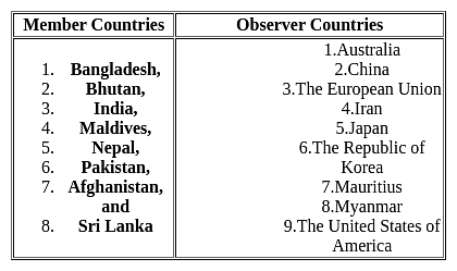
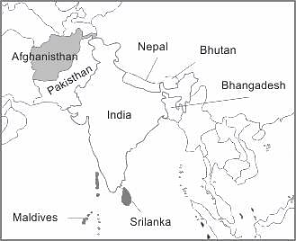
  • At that time there were 8 member countries, Bangladesh, Bhutan, India, Maldives, Nepal, Pakistan, Afghanistan, and Sri Lanka
  • Afghanistan joined SAARC in 2007.
  • Myanmar has stated it would like to become a full member of the SAARC
  • There are currently nine Observers to SAARC. Russia and Turkey are applied to become observers of SAARC

SAARC in short:

  • Present Secretary-General of the South Asian Association for Regional Cooperation (SAARC) H.E. Esala Ruwan Weerakoon of Sri Lanka appointed on 01 March 2020.
  • The Secretariat of the Association was set up in Kathmandu on 17 January 1987

SAARC specialized bodies are

  1. SAARC Development Fund (SDF)
  2. South Asian University
  3. South Asian Regional Standards Organization (SARSO) has its Secretariat in Dhaka, Bangladesh.
  4. SAARC Arbitration Council
MH SET Paper 2 Mock Test - 7 (Geography) - Question 21

Given below are two statements. One is labelled as Assertion (A) and the other is labelled as Reason (R).

Assertion (A): Development in ICT has led to increase in technical field of education in India.

Reason (R) : There has been increase in investment in ICT sector in India.

Select the correct answer from options given below:

Detailed Solution for MH SET Paper 2 Mock Test - 7 (Geography) - Question 21

The Information and communication is a sector developing at a stupendous rate globally. The Foreign Direct Investment in India has been done most in the ICT sector. Thus, investment in the area has increased considerably. This has led to requirement of skilled workforce for ICT. So, there has been progress in technical education in India, specifically ICT sector due to enormous employment opportunities. Thus, (R) is the correct explanation of (A).

MH SET Paper 2 Mock Test - 7 (Geography) - Question 22

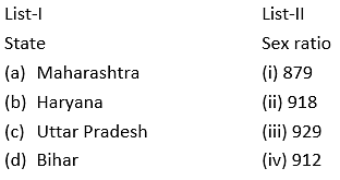
Match the List-I with List-II

Choose the correct option:

Detailed Solution for MH SET Paper 2 Mock Test - 7 (Geography) - Question 22

The sex ratio of India, as per the census of India of 2011 is 940 females per thousand males.

  • Haryana is the state with lowest sex ratio of 879.
  • Maharashtra ranks 22nd in the whole country with sex ratio of 929
  • Bihar ranks 25th and has sex ratio of 918
  • Uttar Pradesh has sex ratio of 912 and ranks 26th in India.

Thus, the correct answer is A.

MH SET Paper 2 Mock Test - 7 (Geography) - Question 23
Who among the following has proposed model of development based on principle linear development?
Detailed Solution for MH SET Paper 2 Mock Test - 7 (Geography) - Question 23

Correct Answer: ​Rostow.

Key Points

  • The most popular linear stage models are Rostow’s Stages of Growth Model and the Harrod-Domar Growth Model.
  • One of the first growth theories was that proposed by American economic historian Walt Rostow in the early 1960s. Rostow’s Stages of Growth Model.
  • This approach was formulated by American Economist Walt Whitman Rostow (1916-2003). He argued in his model that the transition into development occurs in a series of stages. Each stage can only be reached through the completion of the previous stage. He asserts that all developed countries have gone through these stages and developing countries are in one of these stages. These stages are as follows:
  • Traditional society is dominated by agriculture and barter exchange, and where science and technology are not understood or exploited.
  • Pre-take-off stage, with the development of education and an understating of science, the application of science to technology and transport, and the emergence of entrepreneurs and a simple banking system, and hence rising savings.
  • Take-off, with positive growth rates in particular sectors and where organized systems of production and reward replace traditional methods and norms.
  • The drive to maturity in this stage takes place after a long period of time. The population involved in agriculture declines while industry becomes more diverse. The overall income per capita increases. The rate of savings and investments is such that it can automatically sustain economic growth.
  • Stage of Mass Consumption at this stage a country’s demand shifts from food, clothing, and other basic necessities to demand luxuries. To satisfy these needs new industries involve their selves in mass production to match consumption.
  • Rostow’s work, like many other accounts of growth, points to the significance of the accumulation of savings to achieve take-off – in this case as a necessary condition for the movement from traditional to developed societies.

Additional Information

  • Rostow's Stages of Growth model is one of the most influential development theories of the 20th century. It was, however, also grounded in the historical and political context in which he wrote. "Stages of Economic Growth" was published in 1960, at the height of the Cold War, and with the subtitle "A Non-Communist Manifesto," it was overtly political. Rostow was fiercely anti-communist and right-wing; he modeled his theory after western capitalist countries, which had industrialized and urbanized. As a staff member in President John F. Kennedy's administration, Rostow promoted his development model as part of U.S. foreign policy. Rostow's model illustrates a desire not only to assist lower-income countries in the development process but also to assert the United States' influence over that of communist Russia.
  • The theories of Rostow, Harrod Domar, and others consider savings to be a sufficient condition for growth and development. In other words, if an economy saves, it will grow, and if it grows, it must develop. Aggregate savings are largely determined by national income, so if income is low, savings will not be accumulated. According to Rostow’s theory, saving between 15% and 20% of income (a savings ratio of 0.15 – 0.2) would be enough to provide the basis for growth. If this level of saving is maintained, growth would also be sustained.

Major criticisms of this approach include:

  • Although saving is regarded as highly significant, modern growth theory takes into account a broad set of growth factors.
  • Other criticisms of the stage theory point to general weakness in terms of the unrealistic assumptions of these models, such as perfect knowledge, stable exchange rates, and constant terms of trade.
  • Most analyses were based on the reconstruction of Europe after World War II, but most developing countries do not have Europe’s institutions, attitudes, financial markets, levels of education, and desire to succeed as found in Europe.
  • Modern theory tends to see savings as a necessary but not sufficient condition for growth.
MH SET Paper 2 Mock Test - 7 (Geography) - Question 24
Which of the following is NOT typically considered a driver of medical tourism?
Detailed Solution for MH SET Paper 2 Mock Test - 7 (Geography) - Question 24

Answer: 4) High-quality healthcare standards in the home country.

Medical tourism refers to the phenomenon of people traveling across international borders to access medical treatments. Several factors drive this trend, ranging from cost considerations to the availability of specialized treatments. Understanding the motivations behind medical tourism is crucial for countries and healthcare providers looking to attract medical tourists

Key Points

4. High-quality healthcare standards in the home country:

  • This option is not typically considered a driver of medical tourism.
  • In fact, high-quality healthcare standards in one's home country would likely reduce the individual's need or desire to seek medical treatment abroad.
  • People generally engage in medical tourism to access treatments that are either unavailable, cost-prohibitive, or of perceived higher quality than those in their home country, not because they already have access to satisfactory healthcare services.
Additional Information
1. Lower cost of medical procedures in foreign countries:
  • One of the primary drivers of medical tourism is the significant cost savings that can be achieved by undergoing medical procedures in countries where they are offered at a lower price.
  • High costs of healthcare in one's home country can motivate individuals to seek more affordable options abroad without compromising the quality of care.
2. Desire for specialized treatments unavailable in home country:
  • Another key motivation for medical tourism is the pursuit of specialized treatments that may not be available in the individual's home country.
  • This includes cutting-edge medical procedures, experimental treatments, and access to specialists with unique expertise in certain medical conditions.
3. Cultural attractions and tourism opportunities offered by destination:
  • While not the primary driver, the opportunity to combine medical treatment with vacation-like activities in the destination country can be an appealing factor for some medical tourists.
  • This aspect of medical tourism allows individuals to enjoy the cultural and tourism offerings of the destination while receiving medical care.
Important Points
  • As medical tourism continues to grow, it's important for destination countries and providers to understand the diverse factors motivating patients to travel for healthcare.
  • Ensuring high standards of care, transparent communication, and supportive services can enhance their attractiveness to potential medical tourists.
  • Moreover, addressing potential ethical and regulatory issues associated with medical tourism is vital for creating a sustainable and responsible medical tourism industry.
MH SET Paper 2 Mock Test - 7 (Geography) - Question 25
what is a MAIN factor driving the shift in tourist demographics?
Detailed Solution for MH SET Paper 2 Mock Test - 7 (Geography) - Question 25

Answer: ​2) Growing affordability and accessibility of travel options.

In recent years, the demographics of global tourism have undergone significant shifts, with more diverse groups of people traveling than ever before. Various factors have contributed to this transformation, but one of the most impactful has been the growing affordability and accessibility of travel options. This trend has democratized travel, breaking down barriers that previously limited the ability of numerous populations to explore new destinations.

Key Points
Growing affordability and accessibility of travel options:
  • The rise of budget airlines, the proliferation of online travel agencies, and the increasing availability of affordable accommodation options, such as hostels and vacation rentals, have made travel more accessible to a broader range of income levels.
  • Additionally, the digital revolution has simplified the process of researching and booking travel, making it easier for individuals to customize their trips to fit their budgets and preferences.
  • This democratization of travel has enabled a more diverse demographic, including younger travelers, families, and people from emerging economies, to participate in global tourism.
Additional Information
Increased travel restrictions due to geopolitical tensions:
  • While increased travel restrictions can influence patterns of tourism, they are more likely to deter or redirect travel rather than fundamentally shift demographics.
  • Geopolitical tensions and associated travel restrictions tend to have a temporary and region-specific impact, rather than driving a broad and lasting change in tourist demographics.
Popularity of all-inclusive resorts and traditional sight-seeing tours:
  • The popularity of all-inclusive resorts and traditional sight-seeing tours reflects the preferences of certain tourist segments but does not represent a primary driver of the shift in demographics.
  • While these options remain attractive for travelers seeking convenience and predictability, they do not inherently diversify the tourist population or expand access to travel on a large scale.
Decline in interest in adventure travel and cultural immersion:
  • Contrary to a decline, there has been a growing interest in adventure travel and cultural immersion experiences among tourists seeking authentic and memorable experiences.
  • This trend reflects a shift in consumer preferences toward more personalized and unique travel experiences but does not directly influence the broadening demographics of travelers.
  • The increase in diverse travel experiences actually complements the democratization of travel, catering to the varied interests of the expanding tourist population.
Important Points
  • The growing affordability and accessibility of travel have profound implications for the tourism industry and destinations worldwide.
  • It encourages not only a larger volume of travelers but also a richer diversity of tourist experiences, as destinations seek to cater to the varied interests and needs of a broader audience.
  • This trend underscores the importance of sustainable and inclusive tourism practices to ensure that the benefits of increased travel are widely shared and that destinations can manage the environmental and social impacts of tourism.
MH SET Paper 2 Mock Test - 7 (Geography) - Question 26

“Intelligent participation in any discussion requires a knowledge of map of the world” – said by

Detailed Solution for MH SET Paper 2 Mock Test - 7 (Geography) - Question 26

Maps- A map is a representation of the earth drawn on a flat surface according to scale. Maps help in understanding the learning concepts. Maps are helpful in teaching Social sciences. In social sciences, maps are very important for learning many geographical, historical, and economic concepts. It is important for a teacher to teach students how to read maps. Children must know the technique of reading maps.


Rudyard Kipling says, “Intelligent participation in any discussion requires a knowledge of a map of the world”.

Additional Information 


Hence, we can conclude that the statement, “Intelligent participation in any discussion requires a knowledge of map of the world” is said by Rudyard Kipling.

MH SET Paper 2 Mock Test - 7 (Geography) - Question 27

Identify the INCORRECT statement(s) (S1, S2, S3) pertaining to the Vector data Model in GIS.

S1 : Topology is static and any updation /editing of vector data requires re-building of topology.

S2: Accurate geographic location of data can be maintained.

S3 : Continuous data like elevation data can be effectively represented in vector form.

Detailed Solution for MH SET Paper 2 Mock Test - 7 (Geography) - Question 27

Explanation:

GIS (Geographical Information System):

  • Geographical Information Systems (GIS) is defined as the capturing, storing, processing, and presentation of spatially referenced data.

  • This spatial data can be manipulated in different formats and patterns. One of the most important formats is the vector data model which holds topological relationships between geographic features.

  • These vector data can be derived from different methods, for example, using scanning of analog maps into raster formats and then digitizing them into vector forms.

Vector Data Model:

  • Vector data is used in GIS because of the precise nature of its representation method, storage efficiency, the quantity of its cartographic output, and the availability of functional tools for operations like map projection, overlay, and analysis.
  • In vector data models, points, lines, and polygons are used to represent spatial features or objects with clear spatial locations and boundaries.

  • Examples of vector data features are; boreholes as point features, drainage gutters as line features, and buildings as polygon features.

  • Vector data structure can be grouped into four classes namely:

  1. Simple features (non-topological).

  2. Topological features.

  3. Network data model and TIN data model.

  4. Georelational data model and Object-Based Data Model.

MH SET Paper 2 Mock Test - 7 (Geography) - Question 28
Harmattan' warm and dry wind is a local wind found in
Detailed Solution for MH SET Paper 2 Mock Test - 7 (Geography) - Question 28

The correct answer is the Sahara desert of Africa.

Key Points

  • Harmattan wind
    • It is found over the Sahara desert of Africa during summer.
    • It changes warm and moisture climatic conditions of the western coast of Africa into warm and dry.
    • These are also called doctor winds.
    • It reduces the visibility to zero.

Additional Information

  • Norwester is a warm wind found in New Zealand.
  • Santa Ana is a warm wind found in South California.
  • Chinook is the warm and dry wind blowing on the leeward side Rocky Mountains.
MH SET Paper 2 Mock Test - 7 (Geography) - Question 29

Which of the following is/are true about the Amazon basin?

(A) The river Nile flows through this region.

(B) Both days and nights weather is almost equally hot and humid here.

(C) At night, the temperature goes down, but the humidity remains high.

Choose the correct option.

Detailed Solution for MH SET Paper 2 Mock Test - 7 (Geography) - Question 29

The correct answer is (B) and (C) are true.

Key Points

  • The correct answer for the question is option 4, which is "(B) and (C) are true".
  • Explanation:
    • Option (A) is incorrect because the river Nile doesn't flow through the Amazon basin.
    • The Amazon River is the main river in this region.
    • Option (B) is true because the Amazon basin has a tropical climate with high temperatures and humidity throughout the year.
    • Option (C) is also true because although the temperature drops at night, the humidity remains high in the Amazon basin due to the region's dense forest cover and proximity to the equator.

Additional Information

  • The Amazon basin is located in South America and covers an area of approximately 7 million square kilometers.
  • The region is known for its dense rainforest and diverse wildlife, including species like jaguars, anacondas, and macaws.
  • The Amazon River is the second longest river in the world and is a significant source of freshwater for the region.
MH SET Paper 2 Mock Test - 7 (Geography) - Question 30

Match List-I with List-II and select the correct answer from the codes given below :
Choose the correct option from below:

Detailed Solution for MH SET Paper 2 Mock Test - 7 (Geography) - Question 30

Post modernism is an approach in human geography. It is against the concept of modernism and rejects all the statements the theory gives.

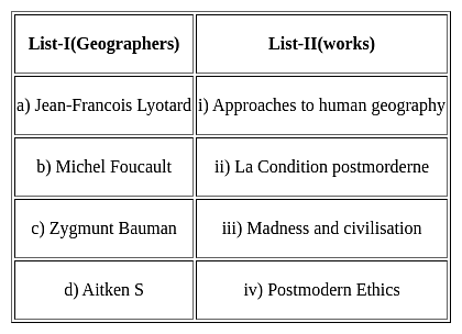
La condition postmorderne was the work of Jean Francois Lyotard.

Madness and civilization is the work of Michel Foucalt.

Postmodern Ethics is the work of Zygmunt Bauman.

Approaches to human geography is the work of Aitken S.

View more questions
Information about MH SET Paper 2 Mock Test - 7 (Geography) Page
In this test you can find the Exam questions for MH SET Paper 2 Mock Test - 7 (Geography) solved & explained in the simplest way possible. Besides giving Questions and answers for MH SET Paper 2 Mock Test - 7 (Geography), EduRev gives you an ample number of Online tests for practice

Top Courses for MAHA TET

Download as PDF

Top Courses for MAHA TET