CSIR NET Earth Science Exam  >  CSIR NET Earth Science Tests  >  CSIR NET Earth Science Mock Test - 2 - CSIR NET Earth Science MCQ

CSIR NET Earth Science Mock Test - 2 - CSIR NET Earth Science MCQ


Test Description

30 Questions MCQ Test - CSIR NET Earth Science Mock Test - 2

CSIR NET Earth Science Mock Test - 2 for CSIR NET Earth Science 2024 is part of CSIR NET Earth Science preparation. The CSIR NET Earth Science Mock Test - 2 questions and answers have been prepared according to the CSIR NET Earth Science exam syllabus.The CSIR NET Earth Science Mock Test - 2 MCQs are made for CSIR NET Earth Science 2024 Exam. Find important definitions, questions, notes, meanings, examples, exercises, MCQs and online tests for CSIR NET Earth Science Mock Test - 2 below.
Solutions of CSIR NET Earth Science Mock Test - 2 questions in English are available as part of our course for CSIR NET Earth Science & CSIR NET Earth Science Mock Test - 2 solutions in Hindi for CSIR NET Earth Science course. Download more important topics, notes, lectures and mock test series for CSIR NET Earth Science Exam by signing up for free. Attempt CSIR NET Earth Science Mock Test - 2 | 150 questions in 180 minutes | Mock test for CSIR NET Earth Science preparation | Free important questions MCQ to study for CSIR NET Earth Science Exam | Download free PDF with solutions
CSIR NET Earth Science Mock Test - 2 - Question 1

Which one of the following wavelengths of visible spectrum penetrates deepest in the oceanic euphoric layer?

Detailed Solution for CSIR NET Earth Science Mock Test - 2 - Question 1

Blue light wavelengths of visible spectrum penetrate deepest in the oceanic euphoric layer.

The minimum absorption, and therefore the greatest penetration is around λ =420nm, which is on the boundary between blue and violet light. The intensity of sunlight peaks between λ =500λ =500 and 550550nm and it falls rapidly at smaller wavelengths.

So even though water absorbs least at violet wavelengths the light intensity decreases because there isn’t that much violet light in sunlight.

The maximum penetration at around λ = 475λ =475nm is a tradeoff between the decreased absorption and decreased intensity as the wavelength decreases.

CSIR NET Earth Science Mock Test - 2 - Question 2

In The Quaternary Period, sea level was the highest at (December)

Detailed Solution for CSIR NET Earth Science Mock Test - 2 - Question 2

Quaternary period is during the most recent ice-ages. During this period, Continental glaciers advanced equatorward and alpine glaciers advance downslope which resulted as large scale scouring and erosion.

Land surface is depressed under up to 3kms depth of ice resulted as migration of animal and plant species. Sea level was at 125ka in that period.
1 Crore+ students have signed up on EduRev. Have you? Download the App
CSIR NET Earth Science Mock Test - 2 - Question 3

The Elastic Rebound Theory is associated with

Detailed Solution for CSIR NET Earth Science Mock Test - 2 - Question 3

This theory explains the mode and cause of the earthquakes. The Elastic Rebound Theory is given by Harry Fielding Reid. This theory was one of the first satisfactory theory related to earthquakes.

CSIR NET Earth Science Mock Test - 2 - Question 4

The place which experiences the seismic event first is called

Detailed Solution for CSIR NET Earth Science Mock Test - 2 - Question 4

The place of the occurrence of an earthquake or the source point is called as focus. Faults denote weaker zones in the Earth's crust. Epicentre is the place where the seismic event is first experienced.

CSIR NET Earth Science Mock Test - 2 - Question 5

The density range lies between 2.5 and 4.5 g/cc for

Detailed Solution for CSIR NET Earth Science Mock Test - 2 - Question 5

The non-metallic minerals have low values of density, ranging between 2.5 and 4.5 g/cc, whereas metallic minerals and ores have densities as high as 20 g/cc.

CSIR NET Earth Science Mock Test - 2 - Question 6

The ocean seaways/gateways play a critical role in the evolution of global ocean circulation, climate, and marine biota. What is the approximate timing of closing of panama isthmus?

Detailed Solution for CSIR NET Earth Science Mock Test - 2 - Question 6

The ocean seaways/gateways play a critical role in the evolution of global ocean circulation, climate, and marine biota. Central America volcanic arc and South America collided in Miocene, resulted closing of Bering Strait and panama isthmus. The results of closing of panama isthmus were, climate change leading to the waxing and waning of ice sheets on Northern Hemisphere, changed in ocean and atmosphere circulation and global climate change.

CSIR NET Earth Science Mock Test - 2 - Question 7

In which of the following environments do sediments show the poorest sorting? 

Detailed Solution for CSIR NET Earth Science Mock Test - 2 - Question 7

Sediment sorting is the degree of dispersion of a grain-size distribution around a central value (mean, median, or mode). The measurement of the degree of sorting of a grain-size distribution is calculated by any of the statistical dispersion measurements. Among them, the standard deviation is the most common.

Sorting reflects both sediment source and transport. Aeolian-transported sediments are the best sorted and glacial sediments is the poorest sorted.

CSIR NET Earth Science Mock Test - 2 - Question 8

Saprolite forms in the.

Detailed Solution for CSIR NET Earth Science Mock Test - 2 - Question 8

Saprolite is a chemically weathered rock that form in the lower zones of the soil profiles.

It represents deep weathering of the bedrock surface. The colour of saprolites comes from the ferric compounds available in the most of the outcrops.

Deeply weathered profiles are extensively found on the continental landmasses between 35oN latitudes and 35oS.

CSIR NET Earth Science Mock Test - 2 - Question 9

In which among the following throughflow pathways does the water travel through the finest soil pores?

Detailed Solution for CSIR NET Earth Science Mock Test - 2 - Question 9

Matrix flow is the throughflow pathway in which the water travel through the finest soil pores.

It is a relative slow and even movement of water that solutes through the soil while sampling all the pore spaces.

It obeys the convective-dispersion theory, which assumes that the water follows an average flow path through the soil.

CSIR NET Earth Science Mock Test - 2 - Question 10

Match the rocks/minerals with their Indian occurrences.
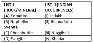
(A)  (B)  (C)  (D)

Detailed Solution for CSIR NET Earth Science Mock Test - 2 - Question 10

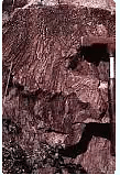
Komatite

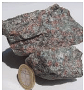
Eclogite

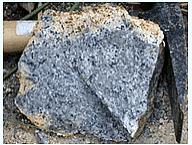
Nepheline Syenite

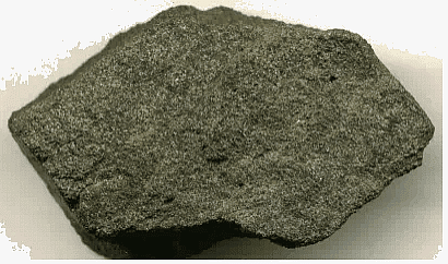
Phosphorite

Komatite is an ancient ultramafic volcanic rock.

Nepheline Syenite is silica under saturated plutonic rock with nepheline replacing orthoclase.

CSIR NET Earth Science Mock Test - 2 - Question 11

Match the following plate boundaries, tectonic processes and geographic examples
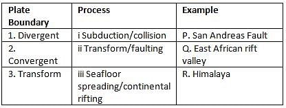
Detailed Solution for CSIR NET Earth Science Mock Test - 2 - Question 11

CSIR NET Earth Science Mock Test - 2 - Question 12

Which one of the following element’s residence time is less than that of the residence time of sea water 103 to 104 years?

Detailed Solution for CSIR NET Earth Science Mock Test - 2 - Question 12
CSIR NET Earth Science Mock Test - 2 - Question 13

Percentage of total gaseous mass of the atmosphere contained in the troposphere is

Detailed Solution for CSIR NET Earth Science Mock Test - 2 - Question 13

The lower most layer of the atmosphere is troposphere. It ranges in thickness from 8Km at the poles to 16Km over the equator. The troposphere is bounded above by the tropopause.

Above the troposphere is the stratosphere. Temperature usually declines with increasing altitude in the troposphere. The troposphere is denser than the layers of the atmosphere above it because of the weight compressing it. It contains 75% total gaseous mass of the atmosphere.

It is primarily composed of nitrogen 78% and oxygen 21% with only small concentrations of other trace gases. Nearly all atmospheric water vapour or moisture is found in the troposphere.

CSIR NET Earth Science Mock Test - 2 - Question 14

Which of the following are examples of river training works?

i. Groynes or spurs

ii. Guide bank system

iii. Levees or embankment

iv. Pitched islands

v. Bank protection and pitched banks

Detailed Solution for CSIR NET Earth Science Mock Test - 2 - Question 14

River training works are classified into three types:

Low water training for rivers is also known as training for depth. It is trained for providing sufficient depth for navigation during the low stage of a river.

High water training for rivers is also known as training for discharge. It is trained for providing sufficient and efficient C/S area for the expeditious passage of maximum flood.

Mean water training for rivers is also known as training for sediment. The river is trained to correct the configuration of the river bed for efficient transport and it also keeps the channel in a good shape.

CSIR NET Earth Science Mock Test - 2 - Question 15

Which of the following causes the dissipating stage of a thunderstorm?

Detailed Solution for CSIR NET Earth Science Mock Test - 2 - Question 15

The thunderstorm begins to dissipate when the downdrafts in the cloud begins to dominate over the updraft.

Since the warm moist air can no longer rise, the cloud droplets can no longer form.

The storm dies out with light rain as the cloud disappears from the bottom to the top.

The whole process takes about one hour for an ordinary thunderstorm to complete. The supercell thunderstorms are much larger, more powerful, and last for several hours.

CSIR NET Earth Science Mock Test - 2 - Question 16

Ice from more easily in

Detailed Solution for CSIR NET Earth Science Mock Test - 2 - Question 16

As the temperature decreases, its volume decreases, and density increases. As the surface water reaches about 4℃, it becomes denser and sinks to the bottom allowing the less dense water to surface up. As temperature falls below 4℃, surface water becomes lighter (less dense) compared to the water below and floats until it freezes. Once frozen, the ice insulates the water at the bottom from cooling so its temperature is maintained between 0 and almost 4℃, keeping it from freezing.

The freezing point of seawater decreases as salt concentration increases. At typical salinity, it freezes at about -2℃ 28℉.

.So, ice form more easily in low salinity and shallow water.

CSIR NET Earth Science Mock Test - 2 - Question 17

Tidal amplitude increases from south to north along the west coast of India because of the increase in the

Detailed Solution for CSIR NET Earth Science Mock Test - 2 - Question 17

Along the west coast of India, there is an increase in width of continental shelf south to north as the figure below.

Tidal amplitude increases with an increase in continental shelf. Tidal range is low in the south along the west coast of India and it increases towards north.

The tides are found to be mixed semidiurnal type in the southern part of the shelf and become more semidiurnal type further north.

CSIR NET Earth Science Mock Test - 2 - Question 18

Which of the following statement about river channel velocity is correct?

Detailed Solution for CSIR NET Earth Science Mock Test - 2 - Question 18

Velocity is in all areas of a river channel. Velocity varies vertically and laterally across the river.

In a straight river channel, velocity is always greatest in the middle away from the banks and bed of the channel.

In deeper places, the flow is faster while in shallower places the flow is slower because there is more surface contact and friction in shallower places.

Average flow velocity at a cross section occurs at 0.6 depth. Velocity is higher over steeper gradients.

CSIR NET Earth Science Mock Test - 2 - Question 19

The temperature and pressure at which the three phases of water co-exist known as the triple point occurs at the temperature of

Detailed Solution for CSIR NET Earth Science Mock Test - 2 - Question 19
Minerals may have different phases at different temperatures and pressures. Phase diagrams relate the phases to temperature and pressure. For example, water has three phases i. e. , solid, liquid, and gaseous. If water is placed in a closed vessel with the air removed and the temperature adjusted to 0.01, the three phases will co-exist.

There will be liquid water, some ice floating on the surface, and water vapour above. The pressure of the water vapour will be only 0.00603 atm or 4.57 mmHg.

The temperature and pressure at which the three phases co-exist is called the triple point.

Three lines radiate from the triple point, one separating ice from water vapour, the second one separating ice from liquid water, and a third separating liquid water from water vapour.

CSIR NET Earth Science Mock Test - 2 - Question 20

Compared to clay, fine grained sandstone has

Detailed Solution for CSIR NET Earth Science Mock Test - 2 - Question 20

Coarse-grained rocks are usually more permeable than fine-grained rocks, and sands are more permeable than clays.

Well-rounded coarse-grained sediments usually have higher porosity than fine-grained sediments, because the grains do not fit together well.

CSIR NET Earth Science Mock Test - 2 - Question 21

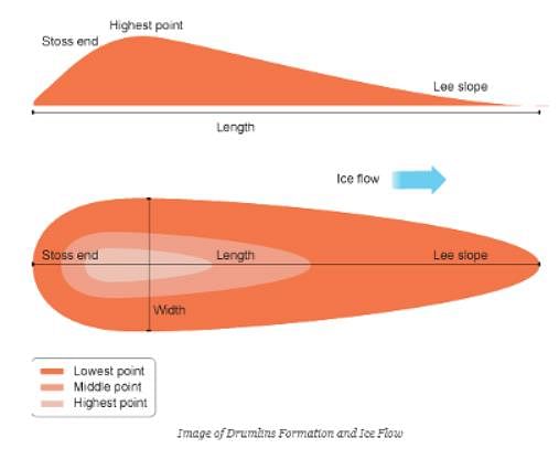
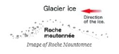
Identify the correct pair of glacial landforms that provide information about the direction of ice motion.

Detailed Solution for CSIR NET Earth Science Mock Test - 2 - Question 21

A drumlin is an elongated hill in the shape of an inverted spoon or half-buried egg formed by glacial ice acting on underlying unconsolidated till or ground moraine.

A roche moutonnee is a rock hill shaped by the passage of ice to give a smooth up-ice side & rough, plucked and cliff-girt surface on the down-ice side. Upstream surface is marked with striations. They are aligned roughly parallel to ice flow.

CSIR NET Earth Science Mock Test - 2 - Question 22

Which of the following clouds is most likely to produce hail?

Detailed Solution for CSIR NET Earth Science Mock Test - 2 - Question 22

Cumulus clouds are fair-weather clouds but as they get big enough to produce thunderstorms, they are called cumulonimbus. Cumulonimbus clouds are formed by upwelling plumes of hot air that produce turbulence on their upper surfaces. When it takes heat to evaporate water from Earth’s surface, heat is released.

It then condenses to form clouds. In thunderheads, this energy is capable to produce hail, damage winds, lightning, torrential rain, and sometimes tornadoes.

When thunderheads reach high elevations, their tops encounter high winds leading to “anvil tops. “

CSIR NET Earth Science Mock Test - 2 - Question 23

Pre-Holocene events that coincided with the destruction of nor them hemisphere ice shelves and release of large volume of sea ice, icebergs and fresh water into the oceans are known as

Detailed Solution for CSIR NET Earth Science Mock Test - 2 - Question 23

Pre-Holocene events that coincided with the destruction of nor them hemisphere ice shelves and release of large volume of sea ice, icebergs and fresh water into the oceans are known as Heinrich events. It is a natural phenomenon. They occurred during five of the last 7 ice ages. This was 1st discovered by Hartmut Heinrich.

CSIR NET Earth Science Mock Test - 2 - Question 24

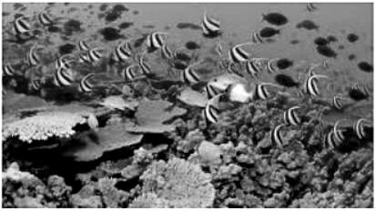
Coral reef ecosystems are oases of life in the oceans, because of their ability to

Detailed Solution for CSIR NET Earth Science Mock Test - 2 - Question 24

Coral reef ecosystems are oases of life in the oceans, because of their ability to support a lot of biodiversity. They are as productive as tropical rainforests. Akm2 of a healthy coral reef can yield an average of 15 tons of fish and other seafood per year. Mollusks, marine turtles, sea horses, starfish and sea urchins are formed more in coral areas.

CSIR NET Earth Science Mock Test - 2 - Question 25

The river valleys are typically of which shaped sections?

Detailed Solution for CSIR NET Earth Science Mock Test - 2 - Question 25

A river valley is the result of down-cutting and bank erosion by the river. Since most of the river erosion processes are concentrated along the bottom of a river channel, especially in the mountainous regions, the resulting river valley has a typical V-shaped cross-section.

CSIR NET Earth Science Mock Test - 2 - Question 26

We have, centre = (3, 4) and radius = 5 equation of circle having centre (h, k) and radius a is (x - h)2 + (y - k)2 = a2
⇒ (x - 3)2 + (y - 4)2 = 25
For x-intercept
Put y = 0, we get (x - 3)2 + 16 = 25 ⇒ (x - 3)2 = 9
⇒ x - 3 = 3 and 3 ⇒ x = 6 and 0
For y-intercept
Put x = 0, we get 9 + (y - 4)2 = 25 ⇒ y - 4 = 4 and -4 = y = 8 and 0
Hence, the x-intercept is 6 and y intercept is 8.

Detailed Solution for CSIR NET Earth Science Mock Test - 2 - Question 26

CSIR NET Earth Science Mock Test - 2 - Question 27

Which of the following has the lowest albedo % ?

Detailed Solution for CSIR NET Earth Science Mock Test - 2 - Question 27

Albedo is defined as the ratio of reflected solar radiation to total received solar radiation.

Object which has the largest reflection has highest albedo. Vegetation has the lowest albedo since it absorbs maximum amount of solar radiation.

CSIR NET Earth Science Mock Test - 2 - Question 28

During winter the western cyclonic disturbances originate from

Detailed Solution for CSIR NET Earth Science Mock Test - 2 - Question 28

A western disturbance is an extra-tropical storm that originates in the Mediterranean region. It brings sudden winter rain to the north-western part of the Indian sub-continent. It refers to a non-monsoonal precipitation pattern, which is driven by the Westerlies.

The moisture driving these storms generally originates over the Mediterranean Sea and the Atlantic Ocean. In extra-tropical storms, the moisture usually carried in the upper atmosphere, unlike their tropical counterparts where the moisture is carried in the lower atmosphere.

In the case of the Indian subcontinent, this moisture is occasionally shed as rain when the storm system encounters the Himalayas. The western disturbances are important for the development of the Rabi crop, such as wheat.

CSIR NET Earth Science Mock Test - 2 - Question 29

Which of the following is the only producer state of diamond in India?

Detailed Solution for CSIR NET Earth Science Mock Test - 2 - Question 29

Madhya Pradesh is the only state in India as well as in Asia with a diamond mine.

The state has produced 28,424 carats of diamonds during the year 2017 - 18. The Majhgawan mine at Panna is the only source of diamonds in Asia producing 30,000 carats every year.

This mine is located in the Panna district of Madhya Pradesh state, which spreads over an area of 80 km starting from the Paharikhera North-East and ending in the Majhgawan South-West having a width of about 30 km.

CSIR NET Earth Science Mock Test - 2 - Question 30

Which type of compressive strength is taken as the most important index property of stones?

Detailed Solution for CSIR NET Earth Science Mock Test - 2 - Question 30

Stones like all other solids fail when subjected to loads beyond their strength. The failure takes place under compressive, tensile and shear forces at different values. It is however, the unconfined compressive strength, which is taken as the most important index property of stones.

View more questions
Information about CSIR NET Earth Science Mock Test - 2 Page
In this test you can find the Exam questions for CSIR NET Earth Science Mock Test - 2 solved & explained in the simplest way possible. Besides giving Questions and answers for CSIR NET Earth Science Mock Test - 2, EduRev gives you an ample number of Online tests for practice
Download as PDF