CSIR NET Earth Science Exam  >  CSIR NET Earth Science Tests  >  CSIR NET Earth Science Mock Test - 3 - CSIR NET Earth Science MCQ

CSIR NET Earth Science Mock Test - 3 - CSIR NET Earth Science MCQ


Test Description

30 Questions MCQ Test - CSIR NET Earth Science Mock Test - 3

CSIR NET Earth Science Mock Test - 3 for CSIR NET Earth Science 2024 is part of CSIR NET Earth Science preparation. The CSIR NET Earth Science Mock Test - 3 questions and answers have been prepared according to the CSIR NET Earth Science exam syllabus.The CSIR NET Earth Science Mock Test - 3 MCQs are made for CSIR NET Earth Science 2024 Exam. Find important definitions, questions, notes, meanings, examples, exercises, MCQs and online tests for CSIR NET Earth Science Mock Test - 3 below.
Solutions of CSIR NET Earth Science Mock Test - 3 questions in English are available as part of our course for CSIR NET Earth Science & CSIR NET Earth Science Mock Test - 3 solutions in Hindi for CSIR NET Earth Science course. Download more important topics, notes, lectures and mock test series for CSIR NET Earth Science Exam by signing up for free. Attempt CSIR NET Earth Science Mock Test - 3 | 150 questions in 180 minutes | Mock test for CSIR NET Earth Science preparation | Free important questions MCQ to study for CSIR NET Earth Science Exam | Download free PDF with solutions
CSIR NET Earth Science Mock Test - 3 - Question 1

A colour is produced due to

Detailed Solution for CSIR NET Earth Science Mock Test - 3 - Question 1

A particular colour is produced by reflection of some and absorption of other components of white light.

CSIR NET Earth Science Mock Test - 3 - Question 2

Selection of excavation method depends on

Detailed Solution for CSIR NET Earth Science Mock Test - 3 - Question 2

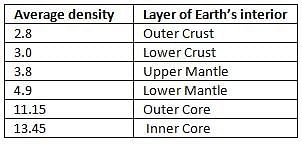
Choice of the right method will, therefore, be possible only when the nature of the rocks and the ground all along the alignment is fully known. This is one of the most important aim and object of geological investigations.

1 Crore+ students have signed up on EduRev. Have you? Download the App
CSIR NET Earth Science Mock Test - 3 - Question 3

For addressing which of the following problems, a coupled ocean-atmosphere model is not essential? 

Detailed Solution for CSIR NET Earth Science Mock Test - 3 - Question 3

Models are useful to understand Earth. Scientists, who study about atmospheres, use the atmosphere model. Like this, scientists who study oceans, use the ocean model.

Some scientists study both the atmosphere and ocean; use the coupled ocean-atmosphere model.

This coupled ocean-atmosphere model is useful in seasonal prediction of the monsoon, ENSO prediction, climate prediction. There are many models for predicting the path of a tropical cyclone like NWP model, GFS model.

A coupled ocean-atmosphere model is not essential for this.

CSIR NET Earth Science Mock Test - 3 - Question 4

Which of the following sediment types has the lowest permeability?

Detailed Solution for CSIR NET Earth Science Mock Test - 3 - Question 4

Permeability of a rock measures the ability of a porous material to allow fluids to pass through it.

It depends on the size of the rock, interconnection, distribution, and volume of the pores of the rock.

The permeability of some rocks in increasing order of permeability is given below:

CSIR NET Earth Science Mock Test - 3 - Question 5

Gulf Stream, Kuroshio Current, Brazil Current and Agulhas Current

Detailed Solution for CSIR NET Earth Science Mock Test - 3 - Question 5

Gulf streams are warm currents, which originate in the Gulf of Mexico from north equatorial current and move in north easterly direction along the eastern coast of North America and reaches the western coasts of Europe near 70oN latitude.

Brazil current is a warm current, which originate in the Brazilian coast near Sun Rock from south equatorial current and moves southward along the east coast of South America upto 40oS latitude.

Kuroshio is a warm current, which originates near Philippines from north equatorial current and moves in north easterly direction along the eastern coast of Asia towards pole.

Agulhas current is warm current, which originates near Madagascar from south equatorial current and moves southward along the eastern coast of Madagascar and joins Mozambique current up to the southern tip of the southern tip of Africa and ultimately diverted eastward.

CSIR NET Earth Science Mock Test - 3 - Question 6

Find the pair which does not match:

Detailed Solution for CSIR NET Earth Science Mock Test - 3 - Question 6

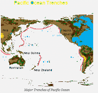
The Mariana Trench or Marianas Trench is the deepest known part of the world’s oceans. It is located in the western Pacific Ocean, to the east of the Mariana Islands. The trench is about 2,550 kilometres long with an average width of 69 kilometres.

The Ninety East Ridge is a linear, age-progressive seamount chain in the Indian Ocean and is named for its near-parallel strike along the 90th meridian at the center of the Eastern Hemisphere.

The Carlsberg Ridge is the northern section of the Central Indian Ridge, a divergent tectonic plate boundary between the African Plate and the Indo-Australian Plate, traversing the western regions of the Indian Ocean.

Bermuda Rise is a cluster of extinct volcanoes in the Atlantic Ocean, including the island of Bermuda.

CSIR NET Earth Science Mock Test - 3 - Question 7

During a break-monsoon condition in summer, the monsoon trough moves

Detailed Solution for CSIR NET Earth Science Mock Test - 3 - Question 7

A zone of low-pressure builds up over NW India as a result of excessive solar radiation. With the advance of the monsoon this heat low gradually extends eastward until it forms an elongated low-pressure roughly parallel to the southern foothills of Himalayas. This refers as monsoon trough.

CSIR NET Earth Science Mock Test - 3 - Question 8

Distinction between crystalline and amorphous substances can always be inferred by

Detailed Solution for CSIR NET Earth Science Mock Test - 3 - Question 8

X-ray diffraction or XRD analysis or XRPD analysis is a unique method in determination of crystallinity of a compound. XRD is primarily used for

ID of crystalline material (for regulatory purposes or during development)

ID of different polymorphic forms (“fingerprints”)

Distinguishing between amorphous and crystalline material

Quantification of the percent crystallinity of a sample

The diffraction from ideal crystalline substances are characterized by Bragg peaks (plots the energy loss of ionizing radiation during its travel through matter) in X-ray diffraction.

The crystalline substances have long range order.

The amorphous substances do not possess this long range order.

So the diffraction from them do not show sharp Bragg peaks.

Bragg peak for protons, α-rays, and other ion rays occurs immediately before the particles come to rest.

CSIR NET Earth Science Mock Test - 3 - Question 9

Which one of the following statements about high tides is INCORRECT?

Detailed Solution for CSIR NET Earth Science Mock Test - 3 - Question 9

Tidal range varies due to changes in the position and alignment of the Moon and Sun relative to Earth. Every 15 days, the largest tidal ranges in semi-diurnal regions occur during spring tides, when the Moon and Sun are in phase around times of new or full Moon; while the smallest tidal ranges occur during neap tides, when the Moon and Sun are out of phase.

In diurnal regions, the largest tidal ranges occur every 15 days during equatorial tides, when the Moon is over the tropics while smallest tidal ranges occur during tropic tides, when the Moon is over the equator.

Tidal range changes as the Moon moves from its closest (perigee) approach to Earth, to its furthest approach (apogee) and back when we discuss about in a month’s time.

Annually, tidal range changes occur as the Sun’s position varies north or south of the equator, and as it moves from its closest to furthest approach to Earth and back. The largest semi-diurnal tidal range occurs during the equinoxes (March and September), while the largest diurnal tidal range occurs during the solstices .

CSIR NET Earth Science Mock Test - 3 - Question 10

Which one of the following statements about Headward erosion is incorrect?

Detailed Solution for CSIR NET Earth Science Mock Test - 3 - Question 10

Headward erosion is erosion at the origin of a stream channel, which causes the origin to move back away from the direction of the stream flow. So, it causes the stream channel to lengthen. It also increases the length of a valley and a canyon. It also increases the sinuosity of a drainage divide.

When sheets of water on a roughly planar surface first enter a depression in it, this erodes the top edge of the depression.

CSIR NET Earth Science Mock Test - 3 - Question 11

In ocean remote sensing infrared sensor gives information about

Detailed Solution for CSIR NET Earth Science Mock Test - 3 - Question 11

Ocean information is collected using different types of remote sensing techniques such as optical, thermal, and microwave. Infrared sensors give information about sea surface temperature. Satellites are useful tools for observing the earth and the ocean that covers more than 70% of the planet.

By remote sensing data collected from their orbits high above the earth, satellites provide us much more information than would be possible to obtain merely from the surface.

Information gathered by satellites can tell us about ocean bathymetry, sea surface temperature, ocean colour, coral reefs, and sea and lake ice.

CSIR NET Earth Science Mock Test - 3 - Question 12

Arrange the correct sequence of mineral according to the Mohs scale of hardness.

Detailed Solution for CSIR NET Earth Science Mock Test - 3 - Question 12

Hardness measures the strength of the structure of a mineral relative to the strength of its chemical bonds.

The Mohs scale of mineral hardness is a qualitative ordinal scale characterizing scratch resistance of various minerals through the ability of harder material to scratch softer material.

It was created in 1812 by German geologist and mineralogist Friedrich Mohs.

The correct sequence of mineral according to the Mohs scale of hardness is:

CSIR NET Earth Science Mock Test - 3 - Question 13

Density contrast is the maximum across the

Detailed Solution for CSIR NET Earth Science Mock Test - 3 - Question 13

CSIR NET Earth Science Mock Test - 3 - Question 14

Getting the wet bulb temperature involves

Detailed Solution for CSIR NET Earth Science Mock Test - 3 - Question 14

The temperature read by a thermometer covered in water soaked cloth over which air is passed. Getting the wet bulb temperature involves isobaric and adiabatic process. If wet-bulb temperature cools adiabatically to saturation by evaporation of water into it, all latent heat being supplied by the volume of air. Thermodynamic wet bulb temperature can be referred as isobaric wet-bulb temperature. The relationship between the isobaric and adiabatic processes is quite obscure.

CSIR NET Earth Science Mock Test - 3 - Question 15

In the southern hemisphere, Earth’s magnetic field and its horizontal component are respectively

Detailed Solution for CSIR NET Earth Science Mock Test - 3 - Question 15

Earth’s magnetic field is the magnetic field that extends from the Earth’s interior out into space.

In the southern hemisphere, Earth’s magnetic field is negative and in northern hemisphere, it’s positive.

Magnetic field has horizontal and vertical components.

In southern hemisphere, horizontal component is positive.

CSIR NET Earth Science Mock Test - 3 - Question 16

The modification of air masses as it moves over the earth’s surface is largely due to

Detailed Solution for CSIR NET Earth Science Mock Test - 3 - Question 16

The modification of air masses occurs as they move away from their source region. In the source region air masses gain properties, which are the characteristic of the underlying surface.

They may be cold or warm and it may also be dry or moist. The stability of the air can also be derived. The more unstable an air mass is, the more likely we are to experience unsettled weather such as wind or rain.

As an air mass moves from its source region the air is modified due to variations in the nature of the underlying surface. Two important processes that may modify an air mass are:

CSIR NET Earth Science Mock Test - 3 - Question 17

The freezing point of seawater

Detailed Solution for CSIR NET Earth Science Mock Test - 3 - Question 17
The freezing and boiling points are greatly affected and controlled by addition or subtraction of salts in water. The saline water freezes slower than fresh water. Pure water freezes at the temperature of 0℃ freezing point.If the salinity of sea water becomes 35% then it would freeze at the temperature of-191. So, the freezing point of seawater decreases with salinity. However, the boiling point of saline water is also high in comparison to fresh water.
CSIR NET Earth Science Mock Test - 3 - Question 18

According to the classification of tropical storms by the World Meteorological Organization, the maximum sustained wind speed in knots for severe tropical storm is

Detailed Solution for CSIR NET Earth Science Mock Test - 3 - Question 18

According to the classification of tropical storms by the World Meteorological Organization, several categories of storm and their maximum sustained wind speeds are given as:

CSIR NET Earth Science Mock Test - 3 - Question 19

The Inter Tropical Convection Zone (ITCZ) is farthermost from the equator over the

Detailed Solution for CSIR NET Earth Science Mock Test - 3 - Question 19

ITCZ is a low pressure belt, encircles Earth near Equator where the trade winds of the Northern and Southern Hemispheres come together. The position of ITCZ varies with the seasons.

ITCZ propagates poleward more prominently over land than over oceans because water has a higher heat capacity than land. So, ITCZ propagates more over Northern Hemisphere than Southern Hemisphere. In July and August, ITCZ is between 5 and 15°north of the equator. But it is further more over the land masses. Over the Indian region it is farthermost of about 30° .

CSIR NET Earth Science Mock Test - 3 - Question 20

Which of the following statements about trade wind inversions is NOT true?

Detailed Solution for CSIR NET Earth Science Mock Test - 3 - Question 20
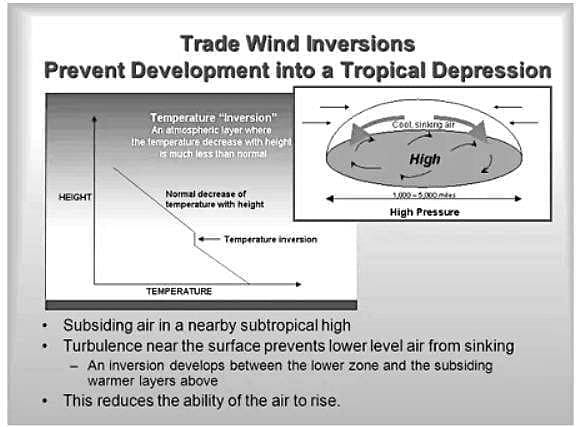
  • The inversion increases in thickness and gains height towards the lower latitudes
  • Considerable cloud development can take place below the inversion layer.
  • The inversion is due to the subsidence associated with the sub-tropical highs.

CSIR NET Earth Science Mock Test - 3 - Question 21

Match the following

Detailed Solution for CSIR NET Earth Science Mock Test - 3 - Question 21

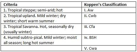
As per Koeppen Classification:

  • Aw = Tropical Savanna. Hot, seasonally dry (usually winter)
  • Cwb = Tropical upland. Cold winter
  • Cfa = Humid subtro- pical. Mild winter; moist all season; long hot summer
  • BSh = Tropical steppe; semi-arid; hot
  • Cwa = Tropical upland. Mild winter; dry winter; short warm summer
CSIR NET Earth Science Mock Test - 3 - Question 22

Eddy motions in the mid-latitude atmosphere are generated due to

Detailed Solution for CSIR NET Earth Science Mock Test - 3 - Question 22

One of the eddy motions in the mid-latitude is mid latitude cyclones.

These result from baroclinic instability.

Baroclinic conditions are usually found in the midlatitudes for large scales while barotropic conditions are found in the tropics.

In baroclinic conditions, density is a function of pressure and temperature i. e. , the density and temperature vary along a pressure surface.

CSIR NET Earth Science Mock Test - 3 - Question 23

The Bergeron- Findeisen process of droplet growth involves

Detailed Solution for CSIR NET Earth Science Mock Test - 3 - Question 23

The Bergeron- Findeisen process is cold-rain process. This process of droplet growth involves ice-crystal growth in mixed phase clouds. This process is much more efficient in producing large particles than smaller ones.

Collision and coalescene mechanism is important for forming raindrops in warmer clouds.

The continued growth of a cloud droplet, once condensation has started, is initially governed by the diffusion of the water vapor molecules toward the droplet.

As condensation proceeds, these droplets grow, coalesce with neighboring drops, and may fall-off or start to slide down the cold wall.

CSIR NET Earth Science Mock Test - 3 - Question 24

Which of the following phenomena is NOT observed in the tropics?

Detailed Solution for CSIR NET Earth Science Mock Test - 3 - Question 24

The Madden–Julian oscillation (MJO) is the largest element of the intraseasonal (30 to 90 day) variability in the tropical atmosphere. It is a large-scale coupling between atmospheric circulation and tropical deep convection.

(ENSO) is an irregularly periodic variation in winds and sea surface temperatures over the tropical eastern Pacific Ocean, affecting climate of much of the tropics and subtropics. The warming phase of the sea temperature is known as El Nino and the cooling phase as La Nina.

CSIR NET Earth Science Mock Test - 3 - Question 25

Which of the following discharge characteristics is responsible for the development of the meander pattern of a river?

Detailed Solution for CSIR NET Earth Science Mock Test - 3 - Question 25

The movement of meanders must be accompanied by the movement of sediment. A dominant discharge is defined as the discharge that transports the most sediment over a long time period.

Dominant discharge may be computed by combining information from a daily sediment-rating curve and a discharge-duration curve. Information on suspended sediment load is generally available, therefore suspended sediment can be considered.

Thus, it is necessary to assume that the total sediment load is proportional to the suspended load. Dominant discharge is responsible for the development of the meander pattern of a river.

CSIR NET Earth Science Mock Test - 3 - Question 26

The fair-weather clouds are

Detailed Solution for CSIR NET Earth Science Mock Test - 3 - Question 26

Cumulus clouds are called fair weather clouds. Clouds can be classified into three types on the basis of heights as above ground level at which they form. They are:

CSIR NET Earth Science Mock Test - 3 - Question 27

Who among the following pronounced the Unit Hydrograph theory?

Detailed Solution for CSIR NET Earth Science Mock Test - 3 - Question 27

The unit hydrograph theory was pronounced by Le-Roy K. Shermen in 1932. It is the unit pulse response function of a linear hydrologic system.

The unit hydrograph of a watershed is defined as a direct runoff hydrograph resulting from 1 inch (1 cm in SI units) of excess rainfall generated uniformly over the drainage area at a constant rate for an effective duration.

Sherman used the word unit to denote a unit of time. Since it has often been interpreted as a unit depth of excess rainfall.

He classified runoff into surface runoff and groundwater runoff and defined the unit hydrograph for use only with the surface runoff.

CSIR NET Earth Science Mock Test - 3 - Question 28

Retraining structures may prove exceptionally successful when

Detailed Solution for CSIR NET Earth Science Mock Test - 3 - Question 28

Retaining structures may prove exceptionally successful where- the ground is neither too fine nor too plastic; the sliding mass is likely to remain dry and the movement is of a shallow nature and limited extent.

CSIR NET Earth Science Mock Test - 3 - Question 29

Nature of slope includes

Detailed Solution for CSIR NET Earth Science Mock Test - 3 - Question 29

The nature of slope includes two important characters of slope. By nature of slope is meant here the type of material of which the land mass is made up and the angle at which this particular mass is inclined with the horizontal.

CSIR NET Earth Science Mock Test - 3 - Question 30

When lightning strikes the ground

Detailed Solution for CSIR NET Earth Science Mock Test - 3 - Question 30

Lightning is discharge of electricity, a giant spark, that occurs in mature thunderstorms. Lightning is actually a flow of electrical current through the air. Rain falling from a thunderstorm will often evaporate before reaching the ground (virga). Lightning then strikes dry ground, starts a fire, and there isn’t any rain to put out or at least slow the spread of the fire. The occurrence of lightning with no rain is called dry lightning. When lightning strikes the ground positive charge is deposited on the ground.

View more questions
Information about CSIR NET Earth Science Mock Test - 3 Page
In this test you can find the Exam questions for CSIR NET Earth Science Mock Test - 3 solved & explained in the simplest way possible. Besides giving Questions and answers for CSIR NET Earth Science Mock Test - 3, EduRev gives you an ample number of Online tests for practice
Download as PDF