


All Exams > UPSC > Weekly Tests for UPSC Preparation > All Questions
All questions of February Week 3 for UPSC CSE Exam
What is the smallest planet? - a) Mercury
- b) Venus
- c) Pluto
- d) Mars
Correct answer is 'A'. Can you explain this answer?
What is the smallest planet?
a)
Mercury
b)
Venus
c)
Pluto
d)
Mars
| | Vikas Choudhury answered |
The smallest planet in regards to both mass and volume is Mercury — at 4,879 km across and 3.3010 x 10²³ kg, this tiny world is nearly 20 times less massive than Earth, and its diameter is about 2 and a half times smaller. In fact, Mercury is closer in size to our Moon than to Earth.

What is the language of the majority of people in the Union Territories of Daman and Diu? - a)Gujarati
- b)Marathi
- c)Konkani
- d)Portuguese
Correct answer is option 'A'. Can you explain this answer?
What is the language of the majority of people in the Union Territories of Daman and Diu?
a)
Gujarati
b)
Marathi
c)
Konkani
d)
Portuguese
| | Anirban Datta answered |
Language of Majority in Union Territories of Daman and Diu
Introduction:
The Union Territories of Daman and Diu are located on the western coast of India. The two territories are separated by the Gulf of Khambhat. Daman and Diu have a rich history and culture, influenced by Portuguese colonization.
Language:
The majority of people in the Union Territories of Daman and Diu speak Gujarati. Gujarati is an Indo-Aryan language spoken by the Gujarati people. It is the official language of the state of Gujarat and is also spoken in other parts of India and abroad.
Other Languages:
Apart from Gujarati, other languages spoken in Daman and Diu are Marathi, Konkani, and Portuguese. Marathi is another Indo-Aryan language spoken by people in Maharashtra and other neighboring states. Konkani is an Indo-Aryan language spoken primarily in the Konkan region of India. Portuguese is a legacy of the Portuguese colonization of the region and is spoken by a small population of people in Daman and Diu.
Conclusion:
In conclusion, the majority of people in the Union Territories of Daman and Diu speak Gujarati. However, other languages such as Marathi, Konkani, and Portuguese are also spoken in the region due to its diverse history and culture.
.
- a)A
- b)B
- c)C
- d)D
Correct answer is option 'C'. Can you explain this answer?
a)
A
b)
B
c)
C
d)
D
 | BT Educators answered |
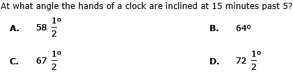
15 past 5 means quarter past 5 = (5:15)
⇒ (11*15 - 60*5)/2 = 67.5
⇒ (11*15 - 60*5)/2 = 67.5
A watch which gains 5 seconds in 3 minutes was set right at 7 a.m. In the afternoon of the same day, when the watch indicated quarter past 4 o'clock, the true time is:
- a)

- b)4 p.m.
- c)
- d)
Correct answer is option 'B'. Can you explain this answer?
a)
b)
4 p.m.
c)
d)
 | S.S Career Academy answered |
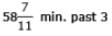
Time from 7 a.m. to 4.15 p.m. = 9 hours 15 min = 37/4 hours
3 min 5 sec of this clock = 3 min. of the correct clock.
⇒ 37/720 hours of this clock = 1/20 hours of the correct clock
⇒ 37 hours of this clock = (1/20 x 720/37 x 37/4) hours of the correct clock.
= 9 hours of the correct clock.
∴ The correct time is 9 hours after 7 a.m. i.e., 4 p.m
3 min 5 sec of this clock = 3 min. of the correct clock.
⇒ 37/720 hours of this clock = 1/20 hours of the correct clock
⇒ 37 hours of this clock = (1/20 x 720/37 x 37/4) hours of the correct clock.
= 9 hours of the correct clock.
∴ The correct time is 9 hours after 7 a.m. i.e., 4 p.m
What is Jammu & Kashmir's best-known wildlife sanctuary? - a)Gulmarg
- b)Ladakh
- c)Nanga Parbat
- d)Dachigam
Correct answer is option 'D'. Can you explain this answer?
What is Jammu & Kashmir's best-known wildlife sanctuary?
a)
Gulmarg
b)
Ladakh
c)
Nanga Parbat
d)
Dachigam
| | Anjali Kapoor answered |
Dachigam Wildlife Sanctuary. Dachigam National Park is located 22 km from Srinagar in Jammu and Kashmir. The name literally stands for 'ten villages', which could be in memory of the ten villages that were relocated in order to create the park.
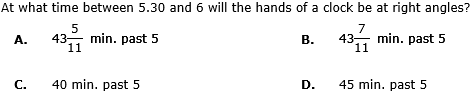
The reflex angle between the hands of a clock at 10.25 is:- a)1800
- b)

- c)1950
- d)

Correct answer is option 'D'. Can you explain this answer?
a)
1800
b)
c)
1950
d)
| | Raksha Choudhary answered |
Angle traced by hour hand in 125/12 hrs = 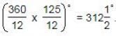
Angle traced by minute hand in 25 min =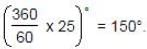
∴ Reflex angle = 3600 -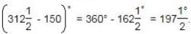
Angle traced by minute hand in 25 min =
∴ Reflex angle = 3600 -
From which language is the word "Monsoon" derived? - a)Arabic
- b)Hindi
- c)Malayalam
- d)Marathi (Mausim season)
Correct answer is option 'A'. Can you explain this answer?
From which language is the word "Monsoon" derived?
a)
Arabic
b)
Hindi
c)
Malayalam
d)
Marathi (Mausim season)
| | Varun Kapoor answered |
The word “monsoon” comes from the Arabic word mausim, meaning season. The word “monsoon” comes from the Arabic word mausim, meaning season. Basically, it describes a seasonal wind shift over a region that is usually accompanied by a dramatic increase in precipitation.
What is another name for the Great Indian Desert? - a)Thar Desert
- b)Rajasthan Desert
- c)Bikaner Desert
- d)Western Desert
Correct answer is option 'A'. Can you explain this answer?
What is another name for the Great Indian Desert?
a)
Thar Desert
b)
Rajasthan Desert
c)
Bikaner Desert
d)
Western Desert
 | Gargi Saha answered |
The Thar Desert, also known as the Great Indian Desert, is a large arid region in the northwesternpart of the Indian subcontinent that covers an area of 200,000 km2 (77,000 sq mi) and forms a natural boundary between India and Pakistan.
Where is there said to be the highest cricket ground in the world? - a)Naini Tal in Uttar Pradesh
- b)Srinagar in Jammu and Kashmir
- c)Chail in Himachal Pradesh
- d)Dehra Dun in Uttar Pradesh
Correct answer is option 'C'. Can you explain this answer?
Where is there said to be the highest cricket ground in the world?
a)
Naini Tal in Uttar Pradesh
b)
Srinagar in Jammu and Kashmir
c)
Chail in Himachal Pradesh
d)
Dehra Dun in Uttar Pradesh
 | Goel UPSC Coaching Center answered |
The Equatorial Counter Current is an eastward moving, wind-driven flowing 10-15m deep current found in the Atlantic, Indian, and Pacific Oceans. More often called the North Equatorial Countercurrent (NECC) , this current flows west-to-east at about 3-10°N in the Atlantic and Pacific basins, between the North Equatorial Current (NEC) and the South Equatorial Current (SEC). The NECC is not to be confused with the Equatorial Undercurrent (EUC) that flows eastward at the equator but at some depth. In the Indian Ocean, circulation is dominated by the impact of the reversing Asian monsoon winds. As such, the current tends to reverse hemispheres seasonally in that basin. The NECC has a pronounced seasonal cycle in the Atlantic and Pacific, reaching maximum strength in late boreal summer and fall and minimum strength in late boreal winter and spring. Furthermore, the NECC in the Atlantic disappears in late winter and early spring.
The NECC is an interesting case because while it results from wind-driven circulation, it transports water against the mean westward wind stress in the tropics. This apparent paradox is concisely explained by Sverdrup theory, which shows that the east-west transport is governed by the north-south change in the curl of the wind stress.
What is the specific feature of the Mercator projection? - a)It distorts the shape of India
- b)It flattens the world
- c)It makes Australia rect-angular
- d)It exaggerates Greenland almost 25 times.
Correct answer is 'D'. Can you explain this answer?
What is the specific feature of the Mercator projection?
a)
It distorts the shape of India
b)
It flattens the world
c)
It makes Australia rect-angular
d)
It exaggerates Greenland almost 25 times.
| | Vikas Choudhury answered |
Mercator projection, type of map projection introduced in 1569 by Gerardus Mercator. ... This projection is widely used for navigation charts, because any straight line on a Mercator projection map is a line of constant true bearing that enables a navigator to plot a straight-line course.
Which is the Lake District of Telangana ? - a)Nizamanad
- b)Eluru
- c)Warangal
- d)Guntur
Correct answer is option 'C'. Can you explain this answer?
Which is the Lake District of Telangana ?
a)
Nizamanad
b)
Eluru
c)
Warangal
d)
Guntur
| | Rishika Basak answered |
Pakhal Lake is about 4 KMs from Narsampet in Warangal district of Telangana.
.
- a)A
- b)B
- c)C
- d)D
Correct answer is option 'B'. Can you explain this answer?
a)
A
b)
B
c)
C
d)
D
 | EduRev UPSC answered |
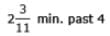
At 5 o'clock, the hands are 25 min. spaces apart.
To be at right angles and that too between 5.30 and 6, the minute hand has to gain (25 + 15) = 40 min. spaces.
55 min. spaces are gained in 60 min.
40 min. spaces are gained in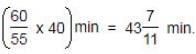
∴ Required time = min. past 5.
To be at right angles and that too between 5.30 and 6, the minute hand has to gain (25 + 15) = 40 min. spaces.
55 min. spaces are gained in 60 min.
40 min. spaces are gained in
∴ Required time =
min. past 5.A clock is started at noom. By 10 mimutes past 5, the hour hand has turned through:
- a)1450
- b)1500
- c)1550
- d)1600
Correct answer is option 'C'. Can you explain this answer?
a)
1450
b)
1500
c)
1550
d)
1600
| | Maya Menon answered |
Angle traced by hour hand in 12 hrs = 360º.
Angle traced by hour hand in 5 hrs 10 min. i.e., 31/6 hrs
= (360/12*31/6)°
= 155º
Angle traced by hour hand in 5 hrs 10 min. i.e., 31/6 hrs
= (360/12*31/6)°
= 155º

A portion of which Karnataka district is almost an enclave in Andhra Pradesh? - a)Tumkur
- b)Kolar
- c)Bellary
- d)Raichur
Correct answer is option 'A'. Can you explain this answer?
A portion of which Karnataka district is almost an enclave in Andhra Pradesh?
a)
Tumkur
b)
Kolar
c)
Bellary
d)
Raichur
| | Kabir Verma answered |
A radiation belt is a layer of energetic charged particles that is held in place around a magnetized planet, such as the Earth, by the planet's magnetic field. The Earth has two such belts and sometimes others may be temporarily created. The discovery of the belts is credited to James Van Allen and as a result the Earth's belts are known as the Van Allen belts. The main belts extend from an altitude of about 1,000 to 60,000 kilometers above the surface in which region radiation levels vary. Most of the particles that form the belts are thought to come from solar wind and other particles by cosmic rays.
The belts are located in the inner region of the Earth's magnetosphere. The belts contain energetic electrons that form the outer belt and a combination of protons and electrons that form the inner belt. Other nuclei, such as alpha particles, are less prevalent. The belts endanger satellites, which must protect their sensitive components with adequate shielding if they spend significant time in the radiation belts
Amrita Devi Bishnoi National Award is given in which of the following fields?- a)In the soil conservation
- b)In the field of wildlife conservation
- c)In the field of women empowerment
- d)In science
Correct answer is option 'B'. Can you explain this answer?
Amrita Devi Bishnoi National Award is given in which of the following fields?
a)
In the soil conservation
b)
In the field of wildlife conservation
c)
In the field of women empowerment
d)
In science
| | Sanjay Rana answered |
The Government of India instituted an ‘Amrita Devi Bishnoi National Award for Wildlife Conservation’ in the memory of Amrita Devi Bishnoi, who in 1731 sacrificed her life along with 363 others for the protection of ‘khejri’ trees in Khejarli village near Jodhpur in Rajasthan.
Consider the following statements about the formation of Tropical Cyclones. 1. There should be continuous supply of abundant dry and cold airmass. 2. Higher value of Coriolis force is required for the origin of these cyclones. 3. They are associated with the inter-tropical convergence (ITC) which extends from 5-30 degrees N latitudes during summer season Q. Select the correct answer using the code given below: - a)2 and 3 only
- b)1 and 2 only
- c)1 and 3 only
- d)1, 2 and 3
Correct answer is option 'A'. Can you explain this answer?
Consider the following statements about the formation of Tropical Cyclones.
1. There should be continuous supply of abundant dry and cold airmass.
2. Higher value of Coriolis force is required for the origin of these cyclones.
3. They are associated with the inter-tropical convergence (ITC) which extends from 5-30 degrees N latitudes during summer season
Q. Select the correct answer using the code given below:
a)
2 and 3 only
b)
1 and 2 only
c)
1 and 3 only
d)
1, 2 and 3
| | Pooja Yadav answered |
**Sultanpur Bird Sanctuary: The Best-Known Bird Sanctuary in Haryana**
Sultanpur Bird Sanctuary, located in the Gurgaon district of Haryana, is the best-known bird sanctuary in the state. Spread over an area of approximately 1.43 square kilometers, the sanctuary is a popular destination for bird enthusiasts, nature lovers, and photographers. It is home to a diverse range of avian species, making it a haven for birdwatching.
**1. Location and Accessibility:**
Sultanpur Bird Sanctuary is situated around 40 kilometers from Delhi, making it easily accessible for both local and international visitors. The sanctuary is well-connected by road and can be reached via private vehicles or public transport. The nearest airport is the Indira Gandhi International Airport, which is approximately 15 kilometers away.
**2. Flora and Fauna:**
The sanctuary is characterized by a mix of wetland, grassland, and woodland habitats, providing an ideal environment for various bird species. It is home to more than 250 bird species, including migratory birds from Central Asia, Siberia, and Europe. Some of the prominent bird species found here include the Siberian crane, white ibis, painted stork, black-necked stork, spot-billed pelican, and various species of ducks, geese, and waders.
**3. Migratory Birds:**
During the winter months, Sultanpur Bird Sanctuary becomes a temporary home for a large number of migratory birds. These birds travel thousands of kilometers to escape the harsh winters of their native regions. The sanctuary provides them with a favorable climate, abundant food, and suitable nesting grounds. This phenomenon attracts birdwatchers and nature enthusiasts from far and wide.
**4. Birdwatching and Activities:**
Sultanpur Bird Sanctuary offers excellent opportunities for birdwatching and photography. Visitors can explore the sanctuary through a network of well-maintained walking trails and observation points. Additionally, there are strategically placed watchtowers and hides that allow visitors to observe the birds without disturbing them. The sanctuary also organizes guided walks and educational programs to create awareness about bird conservation and the importance of wetland ecosystems.
**Conclusion:**
In conclusion, Sultanpur Bird Sanctuary is the best-known bird sanctuary in Haryana due to its diverse range of avian species, convenient location, and excellent birdwatching opportunities. The sanctuary's commitment to conservation and education further adds to its popularity among nature enthusiasts and tourists. Whether it is the resident birds or the spectacular migratory species, Sultanpur Bird Sanctuary never fails to captivate visitors with its natural beauty and avian wonders.
The angle between the minute hand and the hour hand of a clock when the time is 4.20, is:
- a)00
- b)100
- c)50
- d)200
Correct answer is option 'B'. Can you explain this answer?
a)
00
b)
100
c)
50
d)
200
| | Pooja Shah answered |
The angle between hour and minute hand in 4:20 is 10 degrees.
For a minute, the hour hand rotates by 30/60 = 1/2 degrees.
hence, for 20 minutes it rotates by an angle of 20*1/2 = 10 degrees.
For a minute, the hour hand rotates by 30/60 = 1/2 degrees.
hence, for 20 minutes it rotates by an angle of 20*1/2 = 10 degrees.
Practice Quiz or MCQ (Multiple Choice Questions) with solution are available for Practice, which would help you prepare for "Clocks" under Logical Reasoning. You can practice these practice quizzes as per your speed and improvise the topic. The same topic is covered under various competitive examinations like - CAT, GMAT, Bank PO, SSC and other competitive examinations. Q. How many times in a day, the hands of a clock are straight?- a)22
- b)24
- c)44
- d)48
Correct answer is option 'C'. Can you explain this answer?
Practice Quiz or MCQ (Multiple Choice Questions) with solution are available for Practice, which would help you prepare for "Clocks" under Logical Reasoning. You can practice these practice quizzes as per your speed and improvise the topic. The same topic is covered under various competitive examinations like - CAT, GMAT, Bank PO, SSC and other competitive examinations.
Q. How many times in a day, the hands of a clock are straight?
a)
22
b)
24
c)
44
d)
48
 | Raghavendra Sharma answered |
In 12 hours, the hands coincide or are in opposite direction 22 times.
Therefore, In 24 hours, the hands coincide or are in opposite direction 44 times a day.

Who is the first President of the Council of Fort William?- a)Job Charnock
- b)Sir Charles Eyre
- c)Francis Day
- d)Gerald Aungier
Correct answer is option 'B'. Can you explain this answer?
Who is the first President of the Council of Fort William?
a)
Job Charnock
b)
Sir Charles Eyre
c)
Francis Day
d)
Gerald Aungier
| | Pritam Chaudhary answered |
First President of the Council of Fort William
The first President of the Council of Fort William was Sir Charles Eyre. He served as the President from 1690 to 1692. The Council of Fort William was established in 1690 by the East India Company in Fort William, Bengal. It was the first administrative body of the British in India and was responsible for the governance of the British territories in Bengal.
Sir Charles Eyre
Sir Charles Eyre was a British administrator and soldier. He was appointed as the President of the Council of Fort William in 1690. He was also the Governor of Bombay from 1708 to 1710. Sir Charles Eyre was known for his administrative skills and he played an important role in the expansion of the British territories in India.
Establishment of the Council of Fort William
The Council of Fort William was established by the East India Company in 1690. The Council was responsible for the administration of the British territories in Bengal. The Council was headed by the President and it included other members such as the Governor of Fort William, the Chief Justice, and other senior officials.
Functions of the Council
The Council of Fort William had several functions, some of which are:
- Administration of justice
- Collection of revenue
- Maintenance of law and order
- Regulation of trade
- Management of the Company's affairs
Conclusion
In conclusion, Sir Charles Eyre was the first President of the Council of Fort William. The Council of Fort William was established in 1690 by the East India Company and was responsible for the governance of the British territories in Bengal. The Council had several functions such as administration of justice, collection of revenue, maintenance of law and order, regulation of trade, and management of the Company's affairs.
When and to whom did the Danes sell all their settlements in India?- a) 1745-Portuguese
- b) 1776-French
- c) 1800-Dutch
- d) 1845-British
Correct answer is option 'D'. Can you explain this answer?
When and to whom did the Danes sell all their settlements in India?
a)
1745-Portugueseb)
1776-Frenchc)
1800-Dutchd)
1845-British| | Anand Kulkarni answered |
**Answer:**
The Danes, who had established settlements in India, sold all their settlements to the British in 1845. This marked the end of Danish colonial presence in India.
**Danish Settlements in India:**
The Danes had established three settlements in India during the colonial era. These settlements were:
1. Tranquebar (Tharangambadi): Tranquebar was the first Danish settlement in India, established in 1620. It was located on the Coromandel Coast of present-day Tamil Nadu.
2. Serampore (Frederiksnagore): Serampore was established in 1755 and was located near Kolkata in present-day West Bengal. It was an important center for Danish trade and missionary activities.
3. Nicobar Islands: The Danes also briefly controlled the Nicobar Islands in the Bay of Bengal. However, due to its remoteness and lack of economic viability, the Danish control over the Nicobar Islands was short-lived.
**Sale of Danish Settlements:**
Over time, the Danish settlements in India faced various challenges, including conflicts with other European powers, financial difficulties, and declining trade. As a result, the Danes decided to sell their settlements to the British.
The sale of Danish settlements took place in 1845, and it involved negotiations between the Danish and British authorities. The British East India Company, which had already established its dominance in India, saw the acquisition of the Danish settlements as an opportunity to further consolidate its control.
**Reasons for Sale:**
There were several reasons behind the Danish decision to sell their settlements in India:
1. Financial Difficulties: The Danish settlements had been facing financial difficulties for some time. The declining trade and increasing expenses made it difficult for the Danes to sustain their presence in India.
2. Decline in Trade: The Danish settlements had lost their significance as centers of trade. The competition from other European powers, including the British, Dutch, and French, had reduced their trade opportunities.
3. Strategic Considerations: The Danish settlements were vulnerable to attacks from other European powers. Selling the settlements to the British ensured their protection and security under British rule.
4. Lack of Support: The Danish government was not able to provide sufficient support to the settlements due to its own limitations and priorities. This further contributed to the decision to sell the settlements.
**Conclusion:**
In conclusion, the Danes sold all their settlements in India to the British in 1845. This was due to financial difficulties, declining trade, strategic considerations, and lack of support from the Danish government. The sale marked the end of Danish colonial presence in India and further strengthened British control in the region.
.
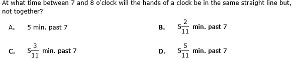
- a)A
- b)B
- c)C
- d)D
Correct answer is option 'D'. Can you explain this answer?
a)
A
b)
B
c)
C
d)
D
 | Future Foundation Institute answered |
When the hands of the clock are in the same straight line but not together, they are 30 minute spaces apart.
At 7 o'clock, they are 25 min. spaces apart.
 Minute hand will have to gain only 5 min. spaces.
55 min. spaces are gained in 60 min.
5 min. spaces are gained in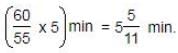
∴ Required time = min. past 7.
At 7 o'clock, they are 25 min. spaces apart.
Minute hand will have to gain only 5 min. spaces.55 min. spaces are gained in 60 min.
5 min. spaces are gained in
∴ Required time =
min. past 7.Which of the following languages was not given classical language status by GOI in 2017?- a)Malayalam
- b)Kannada
- c)Prakrit
- d)Sanskrit
Correct answer is option 'C'. Can you explain this answer?
Which of the following languages was not given classical language status by GOI in 2017?
a)
Malayalam
b)
Kannada
c)
Prakrit
d)
Sanskrit
| | Nilotpal Desai answered |
Introduction:
In 2017, the Government of India (GOI) granted classical language status to three languages - Malayalam, Kannada, and Sanskrit. However, Prakrit was not given classical language status.
Explanation:
1. Classical Language Status:
- The Government of India grants classical language status to languages that have ancient roots and a rich literary tradition.
- Classical languages are recognized for their historical and cultural significance, as well as their contribution to knowledge and learning.
2. Malayalam:
- Malayalam is a language primarily spoken in the southern state of Kerala, India.
- It has a long history and a rich literary tradition, with works dating back to the 9th century CE.
- Malayalam was granted classical language status by the GOI in 2013, recognizing its antiquity and cultural importance.
3. Kannada:
- Kannada is a language primarily spoken in the southern state of Karnataka, India.
- It has a rich literary tradition, with works dating back to the 9th century CE.
- Kannada was granted classical language status by the GOI in 2008, acknowledging its historical significance.
4. Prakrit:
- Prakrit is an ancient language that was widely spoken in ancient India.
- It was the language of the common people and was used extensively in literature, especially in Buddhist and Jain texts.
- However, Prakrit was not granted classical language status by the GOI in 2017.
- The decision not to grant Prakrit classical language status may be attributed to factors such as its limited contemporary usage and the existence of other languages with a stronger literary tradition.
5. Sanskrit:
- Sanskrit is an ancient language of India that has had a profound influence on various aspects of Indian culture, philosophy, and literature.
- It is considered the language of the gods in Hinduism and has been used in religious and scholarly contexts for centuries.
- Sanskrit was granted classical language status by the GOI in 2005, recognizing its importance and contribution to knowledge.
Conclusion:
In 2017, the Government of India granted classical language status to Malayalam and Kannada, but not Prakrit. Sanskrit had already been recognized as a classical language in 2005. The decision to grant classical language status is based on various factors, including the language's historical significance and rich literary tradition.
What is Pantnagar famous for? a)It is the home of the Pant family b)It is an agricultural university and research centre c)It is a pilgrim centre d)It is an industrial cityCorrect answer is option 'B'. Can you explain this answer?
| | Vikas Choudhury answered |
Pantnagar is an industrial town situated in the Udham Singh Nagar district of Uttarakhand state. The town is famous for two reasons. Firstly, the first agricultural university of India was established here in year 1960. Secondly, it houses the Pantnagar Airport of Kumaon region.
Most European powers reached India after crossing the- a)Red Sea
- b)Pacific Ocean
- c)Cape of Good Hope
- d)None of these
Correct answer is option 'C'. Can you explain this answer?
Most European powers reached India after crossing the
a)
Red Sea
b)
Pacific Ocean
c)
Cape of Good Hope
d)
None of these
| | Sanvi Kapoor answered |
The answer is (C) Cape of Good Hope, because the European came to India by land from Iraq, Saudi Arabia then Saudi Arabia and Iraq are wanted to European by this land to India then the Vasco The Gama came to India from Portugal by water way from Cape of Good Hope so all European come from this way to India.
.
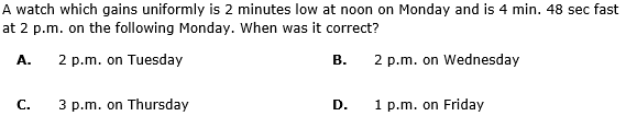
- a)A
- b)B
- c)C
- d)D
Correct answer is option 'B'. Can you explain this answer?
a)
A
b)
B
c)
C
d)
D
 | Aryan Goyal answered |
**Solution:**
To solve this question, we need to find the correct time when the watch is showing the correct time. Let's analyze the given information step by step.
**Step 1: Determine the watch's gain per day**
- The watch gains uniformly, so we can determine its daily gain by finding the difference between the two given times.
- The watch is 2 minutes slow at noon on Monday and 4 minutes 48 seconds fast at 2 p.m. on the following Monday.
- The time difference between these two is 6 days and 2 hours (or 50 hours).
- The watch gains (4 minutes 48 seconds - 2 minutes) in 50 hours.
- To find the daily gain, we divide the overall gain by the number of days:
- Daily gain = (4 minutes 48 seconds - 2 minutes) / 6 days
- Daily gain = 2 minutes 48 seconds / 6 days
- Daily gain = 28 seconds / day
**Step 2: Determine when the watch shows the correct time**
Now, we need to determine the correct time when the watch is neither fast nor slow.
To do this, we need to consider that the watch gains 28 seconds per day. We also know that the watch is 2 minutes slow at noon on Monday. So, we need to calculate the time it takes for the watch to gain 2 minutes (120 seconds).
- Time taken for the watch to gain 120 seconds = (120 seconds) / (28 seconds/day)
- Time taken = 4.2857 days
**Step 3: Determine the correct day and time**
We know that the watch is 2 minutes slow at noon on Monday. To find when the watch shows the correct time, we need to add the time taken from step 2 to Monday noon.
- Correct day = Monday + 4.2857 days
- Correct day = Friday
So, the correct time is on Friday. Now, we need to determine the correct time on Friday.
- Correct time = Noon + 4.2857 days
- Correct time = 1 p.m.
Therefore, the correct time is 1 p.m. on Friday.
**Answer:**
The watch shows the correct time at 1 p.m. on Friday, which corresponds to option D.
Where exactly is Aksai Chin? - a)Near Leh
- b)The north-east corner of Jammu & Kashmir
- c)Along the Zaskar mountains
- d)South of the Siachen Glacier
Correct answer is option 'B'. Can you explain this answer?
Where exactly is Aksai Chin?
a)
Near Leh
b)
The north-east corner of Jammu & Kashmir
c)
Along the Zaskar mountains
d)
South of the Siachen Glacier
| | Kiran Mehta answered |
Aksai Chin is one of the two large disputed border areas between India and China. India claims Aksai Chin as the easternmost part of the Jammu and Kashmir state.
Where exactly is the Chhattisgarh plateau? - a)Morthern Maharashtra
- b)Western Madhya pradesh
- c)Southern Gujarat
- d)Eastern Madhya pradesh
Correct answer is option 'D'. Can you explain this answer?
Where exactly is the Chhattisgarh plateau?
a)
Morthern Maharashtra
b)
Western Madhya pradesh
c)
Southern Gujarat
d)
Eastern Madhya pradesh
| | Vikas Choudhury answered |
Chhattisgarh was a part of the state of Madhya Pradesh. It came to be recognized as a separate state in November 2000. Raipur is the capital of Chhattisgarh. The state is located in the central part of India.
The geographical location of Chhattisgarh is 17 degree 46 min north to 24 degree 5 min north latitude and from 80 degree 15 min east to 84 degree 20 min east longitude. Madhya Pradesh borders Chhattisgarh in the north western part. Maharashtra borders on the west and Andhra Pradesh lies in its south. Orissa is located in the eastern side. The state of Jharkhand borders Chhattisgarh in the north eastern part. Chhattisgarh Geography is diverse and thus is very interesting.
Which lake is partly in Andhra Pradesh and partly in Tamil Nadu? - a)Stanley Reservoir
- b)Pulicat Lake
- c)Tungabhadra Reservoir
- d)Nagarjunasagar
Correct answer is option 'B'. Can you explain this answer?
Which lake is partly in Andhra Pradesh and partly in Tamil Nadu?
a)
Stanley Reservoir
b)
Pulicat Lake
c)
Tungabhadra Reservoir
d)
Nagarjunasagar
| | Alok Verma answered |
Pulicat Lake
Straddling the borders of Andhra Pradesh and Tamil Nadu, the Pulicat Lake is essentially a brackish water lagoon, rich in floral and faunal diversity.
Kodikkarai is on the Cormandel Coast. On which coast is Kilakkarai? - a)The Malabar Coast
- b)The Fisheries Coast
- c)The Konkan Coast
- d)The Northern Circars
Correct answer is option 'B'. Can you explain this answer?
Kodikkarai is on the Cormandel Coast. On which coast is Kilakkarai?
a)
The Malabar Coast
b)
The Fisheries Coast
c)
The Konkan Coast
d)
The Northern Circars
| | Aruna Singh answered |
Coromandel Coast, broad coastal plain in eastern Tamil Nadu state, southern India. Extending over an area of about 8,800 square miles (22,800 square km), it is bounded by the Utkal Plains to the north, the Bay of Bengal to the east, the Kaveri delta to the south, and the Eastern Ghats to the west. The region derives its name from the Tamil Chola Mandalam (“Land of the Chola,”) an ancient dynasty that ruled the region from the mid-9th century CE to 1279. It also has been known since ancient times as the “land of the temples,” for the many temples that are located along the coast.
The coast has an average elevation of 264 feet (80 metres) and is backed by the Eastern Ghats, a chain of low, flat-topped hills. The shoreline is relatively straight, with several sandbars and an offshore chain of coral islands. The lower courses of the Palar, Ponnaiyar, and Cheyyar rivers and their tributaries, the Pamban and Ponnai, which rise in the Ghats, remain dry during most of the year. There is little forest cover, but marshes, swamps, scrub woodlands, and thorny thickets are common.
Which of the following statements best describes the term ecosystem?- a)A community of people interacting with each other (organism).
- b)The part of the Earth that is inhabited by living organisms.
- c)The interacting organisms in an area together with the non-living constituents of the environment.
- d)Flora and fauna of a geographical area.
Correct answer is option 'C'. Can you explain this answer?
Which of the following statements best describes the term ecosystem?
a)
A community of people interacting with each other (organism).
b)
The part of the Earth that is inhabited by living organisms.
c)
The interacting organisms in an area together with the non-living constituents of the environment.
d)
Flora and fauna of a geographical area.
| | Sanvi Kapoor answered |
All the Biotic Components in an area together with the abiotic constituents of the environment form an ecosystem. Biotic components comprising living organisms and abiotic components comprising physical factors like temperature, rainfall, wind, soil and minerals
In 1955, the President appointed an Official Language Commission under the chairmanship of: - a)G.B. Pant
- b)S.K. Dhar
- c)B.G. Kher
- d)H.N. Kunzru
Correct answer is option 'C'. Can you explain this answer?
In 1955, the President appointed an Official Language Commission under the chairmanship of:
a)
G.B. Pant
b)
S.K. Dhar
c)
B.G. Kher
d)
H.N. Kunzru
| | Mira Sharma answered |
Accordingly, in 1955, the president appointed an Official Language Commission under the chairmanship of B.G. Kher. The commission submitted its report to the President in 1956. The report was examined by a committee of Parliament constituted in 1957 under the chairmanship of Gobind Ballabh Pant.
Hydrogen bomb is based on which of the following reactions?- a)Controlled fusion reaction
- b)Thermonuclear fusion reaction
- c)Controlled fission reaction
- d)Thermonuclear fission reaction
Correct answer is option 'B'. Can you explain this answer?
Hydrogen bomb is based on which of the following reactions?
a)
Controlled fusion reaction
b)
Thermonuclear fusion reaction
c)
Controlled fission reaction
d)
Thermonuclear fission reaction
| | Meera Kapoor answered |
- Hydrogen bomb is based on the 'nuclear fusion' technology. In order to release more energy, atoms have been fused together in the making of H-Bomb.Hydrogen Bombs use fusion, the same way that powers the Sun or any other star.
- Isotopes of hydrogen are forced together to release a much bigger blast — hundred times powerful than the nuclear weapon that has been used in warfare.
With reference to nuclear fusion, consider the following statements:1. During the nuclear fusion reaction two lighter nuclei are joined to make a heavier nucleus.2. Nuclear fusion reactions take place in the Sun and Star. It takes considerable energy to force the nuclei to fuse.Which of the statements given above is/are correct?- a)1 Only
- b)2 only
- c)1 and 2 Only
- d)None of these
Correct answer is option 'C'. Can you explain this answer?
With reference to nuclear fusion, consider the following statements:
1. During the nuclear fusion reaction two lighter nuclei are joined to make a heavier nucleus.
2. Nuclear fusion reactions take place in the Sun and Star. It takes considerable energy to force the nuclei to fuse.
Which of the statements given above is/are correct?
a)
1 Only
b)
2 only
c)
1 and 2 Only
d)
None of these
| | Sanjay Rana answered |
- Fusion means joining lighter nuclei to make a heavier nucleus, most commonly hydrogen isotopes are added together to create Helium. It releases a tremendous amount of energy, according to the Einstein equation, as the mass of the product is little less than the sum of the masses of the original individual nuclei.
- Such nuclear fusion reactions are the source of energy in the Sun and other stars. It takes considerable energy to force the nuclei to fuse. The conditions needed for this process are extreme – millions of degrees of temperature and millions of pascals of pressure.
Consider the following statements:1. The fuels which are produced by plants and animals are called biomass.2. The main Constituent of Biogas is Methane.Which of the statements given above is/are correct?- a)1 Only
- b)2 Only
- c)Both 1 and 2
- d)Neither 1 nor 2
Correct answer is option 'C'. Can you explain this answer?
Consider the following statements:
1. The fuels which are produced by plants and animals are called biomass.
2. The main Constituent of Biogas is Methane.
Which of the statements given above is/are correct?
a)
1 Only
b)
2 Only
c)
Both 1 and 2
d)
Neither 1 nor 2
| | Janhavi Bajaj answered |
Explanation:
1. Biomass:
- Biomass refers to organic materials that come from plants and animals, which can be used as a source of energy.
- These organic materials can be processed to produce biofuels like bioethanol, biodiesel, and biogas.
- Therefore, the statement that fuels produced by plants and animals are called biomass is correct.
2. Biogas:
- Biogas is a type of biofuel that is produced from the anaerobic digestion of organic materials such as agricultural waste, food waste, and sewage.
- The main constituent of biogas is methane, which typically makes up around 50-70% of its composition.
- Therefore, the statement that the main constituent of biogas is methane is also correct.
Therefore, both statements are correct. Biomass is indeed the fuels produced by plants and animals, while methane is the main constituent of biogas.
Arrange the following chronologically:I. Fracois Martin
II. Lenoir
III. Dumas
IV. Dupleix
V. Count de Lally- a)I, II, IV, III, V
- b)II, III, IV, I, V
- c)I, II, III, IV, V
- d)I, II, III, V, IV
Correct answer is option 'C'. Can you explain this answer?
Arrange the following chronologically:
I. Fracois Martin
II. Lenoir
III. Dumas
IV. Dupleix
V. Count de Lally
II. Lenoir
III. Dumas
IV. Dupleix
V. Count de Lally
a)
I, II, IV, III, V
b)
II, III, IV, I, V
c)
I, II, III, IV, V
d)
I, II, III, V, IV
| | Poulomi Sengupta answered |
Chronological Order of Events:
Fracois Martin
Francois Martin was appointed as the Governor of Pondicherry in 1725.
Lenoir
Lenoir is not placed in the correct chronological order based on the information provided.
Dumas
Dumas was the Governor of Pondicherry in 1735.
Dupleix
Dupleix was the Governor of French establishments in India from 1742 to 1754.
Count de Lally
Count de Lally was appointed as the Governor of Pondicherry in 1758.
Therefore, the correct chronological order of events is:
I. Fracois Martin
II. Lenoir
III. Dumas
IV. Dupleix
V. Count de Lally
The correct option is:
c) I, II, III, IV, V
The Portuguese built their first fort on Indian soil in the territory of the Raja of- a)Calicut
- b)Cochin
- c)Daman
- d)None of these
Correct answer is option 'B'. Can you explain this answer?
The Portuguese built their first fort on Indian soil in the territory of the Raja of
a)
Calicut
b)
Cochin
c)
Daman
d)
None of these
| | Mira Choudhury answered |
Portuguese Fort in Cochin:
The Portuguese built their first fort on Indian soil in the territory of the Raja of Cochin. Cochin, also known as Kochi, is a major port city on the southwest coast of India. The fort was constructed in the early 16th century and played a significant role in the Portuguese colonial presence in India.
Reasons for building the fort:
- The Portuguese were seeking to establish a stronghold in the region to control trade routes and protect their interests.
- Cochin was strategically located and offered access to valuable resources and trade opportunities.
- The Raja of Cochin welcomed the Portuguese and allowed them to build the fort as a means of strengthening his own position.
Significance of the fort:
- The fort in Cochin served as a symbol of Portuguese power and influence in the region.
- It provided a strategic base for Portuguese military operations and trade activities.
- The fort also served as a center for European cultural and religious influences in India.
Legacy of Portuguese presence:
- The Portuguese presence in Cochin left a lasting impact on the region, influencing architecture, cuisine, and language.
- The fort in Cochin is now a popular tourist attraction, showcasing the rich history of European colonization in India.
In conclusion, the Portuguese built their first fort on Indian soil in the territory of the Raja of Cochin, marking the beginning of their colonial presence in the region.
The resistance from Arab traders was completely crushed by the Portuguese under - a)Albuquerque
- b)De Almedia
- c)General Pestado
- d)None of these
Correct answer is option 'A'. Can you explain this answer?
The resistance from Arab traders was completely crushed by the Portuguese under
a)
Albuquerque
b)
De Almedia
c)
General Pestado
d)
None of these
| | Anu Choudhary answered |
Correct Answer:A
Albuquerque left Lisbon with Tristão da Cunha in April 1506 to explore the east coast of Africa and build a fortress on the island of Socotra to block the mouth of the Red Sea and cut off Arab trade with India.
Which of the following sets of Articles of the Constitution of India contain provisions pertaining to the official language? - a)Articles 347 to 353
- b)Articles 346 to 354
- c)Articles 342 to 352
- d)Articles 343 to 351
Correct answer is option 'D'. Can you explain this answer?
Which of the following sets of Articles of the Constitution of India contain provisions pertaining to the official language?
a)
Articles 347 to 353
b)
Articles 346 to 354
c)
Articles 342 to 352
d)
Articles 343 to 351
| | Suresh Reddy answered |
Part XVII of the Constitution deals with the official language in Articles 343 to 351
What state is virtually sandwiched between Bangladesh and Myanmar?- a)Tripura
- b)Mizoram
- c)Manipur
- d)Nagaland
Correct answer is option 'B'. Can you explain this answer?
What state is virtually sandwiched between Bangladesh and Myanmar?
a)
Tripura
b)
Mizoram
c)
Manipur
d)
Nagaland
| | Goel UPSC Coaching Center answered |
Subtropical latitudes see trade winds in summer and westerlies in winter due to shift of pressure belts. Pressure Belts shift due to movement of Sun and variance in insolation, The subtropical latitudes has the Mediterranean type climate where there is hot and dry summers and mild and rainy winters.
What is the average value for the amount of organic matter that is present at each step and reaches the next level of consumers?- a)10%
- b)20%
- c)30%
- d)50%
Correct answer is option 'A'. Can you explain this answer?
What is the average value for the amount of organic matter that is present at each step and reaches the next level of consumers?
a)
10%
b)
20%
c)
30%
d)
50%
| | Sanjay Rana answered |
- When green plants are eaten by primary consumers, a great deal of energy is lost as heat to the environment, some amount goes into digestion and in doing work and the rest goes towards growth and reproduction.
- An average of 10% of the food eaten is turned into its own body and made available for the next level of consumers.Therefore, 10% can be taken as the average value for the amount of organic matter that is present at each step and reaches the next level of consumers.
Where is the Keibul Lamjao National park? - a)Assam, near Tezpur
- b)Sikkim, near Gangtok
- c)Manipur, near Loktak lake
- d)Arunachal Pradesh. near Tawang
Correct answer is option 'C'. Can you explain this answer?
Where is the Keibul Lamjao National park?
a)
Assam, near Tezpur
b)
Sikkim, near Gangtok
c)
Manipur, near Loktak lake
d)
Arunachal Pradesh. near Tawang
| | Prisha Nair answered |
Location of Keibul Lamjao National Park
Keibul Lamjao National Park is located in the northeastern state of Manipur, India. It is a unique park that holds significant ecological and cultural importance.
Geographical Context
- Situated near Loktak Lake, the largest freshwater lake in northeastern India.
- The park is in the Bishnupur district of Manipur, surrounded by lush greenery and water bodies.
Significance of Loktak Lake
- Loktak Lake is known for its floating phumdis (vegetation), which support diverse wildlife.
- The lake and the national park together create a unique ecosystem that is home to numerous species, including the endangered Sangai deer (Manipuri brow-antlered deer).
Ecological Importance
- Keibul Lamjao serves as a habitat for various flora and fauna, including migratory birds.
- It helps in maintaining the ecological balance by supporting biodiversity.
Cultural Significance
- The park is not only a wildlife sanctuary but also a site of cultural heritage for the local Manipuri community.
- Traditional practices and the lifestyle of the local people are intertwined with the conservation efforts in the area.
Conclusion
Keibul Lamjao National Park is a vital area for conservation efforts in India, particularly due to its unique floating ecosystem and the endangered species it supports. It is an essential part of Manipur's identity and environmental heritage, making option 'C' the correct answer.
What natural feature separates Pamban Island and Mannar Island? - a)Palk Strait
- b)Gulf of Mannar
- c)Adam's Bridge
- d)Kachativu
Correct answer is option 'C'. Can you explain this answer?
What natural feature separates Pamban Island and Mannar Island?
a)
Palk Strait
b)
Gulf of Mannar
c)
Adam's Bridge
d)
Kachativu
| | Akshita Joshi answered |
Adam's Bridge, also known as Rama's Bridge or Rama Setu, is a chain of limestone shoals, between Pamban Island, also known as Rameswaram Island, off the south-eastern coast of Tamil Nadu, India, and Mannar Island, off the north-western coast of Sri Lanka.
While determining the boiling point of water, the teacher suggested adding some pumice stone pieces to the hard glass test tube containing water. This was done to :- a)avoid bumping
- b)avoid melting of the hard glass test tube
- c)prevent unnecessary loss of heat energy
- d)spread the heat uniformly.
Correct answer is option 'A'. Can you explain this answer?
While determining the boiling point of water, the teacher suggested adding some pumice stone pieces to the hard glass test tube containing water. This was done to :
a)
avoid bumping
b)
avoid melting of the hard glass test tube
c)
prevent unnecessary loss of heat energy
d)
spread the heat uniformly.
| | Radha Iyer answered |
Pumice stone is added to facilitate bubbles so that "Bumping." can be prevented. It frequently happens, especially when the distillation has to be carried out under greatly reduced pressure, that the liquid is liable to boil with bumping. Thus we can measure the boiling point of water more accurately.
Who was General Augier?- a)First President of the Council of Surat
- b)First Governor of Bombay and responsible for its rise into prominance
- c)First President of the Council of Madras
- d)None of the above
Correct answer is option 'B'. Can you explain this answer?
Who was General Augier?
a)
First President of the Council of Surat
b)
First Governor of Bombay and responsible for its rise into prominance
c)
First President of the Council of Madras
d)
None of the above
 | Academic Studio answered |
General Gerald Aungier (often spelled Augier) was appointed the first Governor of Bombay in 1669. He is credited with laying the foundation for Bombay (now Mumbai) to become an important trading center and one of the most significant cities under British control in India. Aungier's tenure is noted for administrative reforms and efforts to improve the infrastructure and defense of Bombay, which led to its growth in importance during the British colonial period.
The Dutch had a stronger navy than the Portuguese. Nevertheless, the Dutch soon realized that it was difficult to trade profitably in pepper and spices in the east without the aid of- a)Cotton textiles from India
- b)The Portuguese controlled ports on the west coast of India
- c)The prevailing regional Indian power in the Deccan
- d)Both (a) and (c)
Correct answer is option 'A'. Can you explain this answer?
The Dutch had a stronger navy than the Portuguese. Nevertheless, the Dutch soon realized that it was difficult to trade profitably in pepper and spices in the east without the aid of
a)
Cotton textiles from India
b)
The Portuguese controlled ports on the west coast of India
c)
The prevailing regional Indian power in the Deccan
d)
Both (a) and (c)
 | Lohit Matani answered |
Despite having a stronger navy than the Portuguese, the Dutch soon realized that to trade profitably in pepper and spices from the East, they needed the support of:
- Cotton textiles from India (d): Indian cotton textiles were highly valued in the Southeast Asian spice markets, and trading these textiles helped the Dutch acquire spices in exchange. Without access to Indian cotton, it was difficult to trade profitably in spices.
- The prevailing regional Indian power in the Deccan (c): The Dutch also needed the cooperation of regional powers, such as the rulers in the Deccan, to secure access to ports and trading routes, as well as to ensure safe passage for their goods.
Thus, both (d) and (c) were crucial for the Dutch to maintain profitable trade in the region.
The centre of Portuguese power in India was- a)Goa
- b)Bijapur
- c)Calicut
- d)Cochin
Correct answer is option 'A'. Can you explain this answer?
The centre of Portuguese power in India was
a)
Goa
b)
Bijapur
c)
Calicut
d)
Cochin
| | Malavika Datta answered |
The correct option is A.
Alfonso de Albuquerque who replaced Almeida as the governor in 1509 AD, and captured Goa from the Sultan of Bijapur in 1510 AD is considered the real founder of the Portuguese power in India. Goa subsequently became the headquarters of the Portuguese settlements in India.
Alfonso de Albuquerque who replaced Almeida as the governor in 1509 AD, and captured Goa from the Sultan of Bijapur in 1510 AD is considered the real founder of the Portuguese power in India. Goa subsequently became the headquarters of the Portuguese settlements in India.
Chapter doubts & questions for February Week 3 - Weekly Tests for UPSC Preparation 2026 is part of UPSC CSE exam preparation. The chapters have been prepared according to the UPSC CSE exam syllabus. The Chapter doubts & questions, notes, tests & MCQs are made for UPSC CSE 2026 Exam. Find important definitions, questions, notes, meanings, examples, exercises, MCQs and online tests here.
Chapter doubts & questions of February Week 3 - Weekly Tests for UPSC Preparation in English & Hindi are available as part of UPSC CSE exam. Download more important topics, notes, lectures and mock test series for UPSC CSE Exam by signing up for free.