


All Exams > UPSC > Oxford Student ATLAS: Maps & Tests > All Questions
All questions of Prelims Based Tests for UPSC CSE Exam
Arrange the following cities from East to West:- Mandalay
- Kolkata
- Kunming
- Dhaka
Select the correct option from the codes given below:- a)1-3-2-4
- b)3-4-1-2
- c)4-2-1-3
- d)3-1-4-2
Correct answer is option 'D'. Can you explain this answer?
Arrange the following cities from East to West:
- Mandalay
- Kolkata
- Kunming
- Dhaka
Select the correct option from the codes given below:
a)
1-3-2-4
b)
3-4-1-2
c)
4-2-1-3
d)
3-1-4-2
| | Arindam Mukherjee answered |
The correct answer is option 'D' (3-1-4-2).
Explanation:
To arrange the cities from East to West, we need to consider their longitudinal positions. The cities with the easternmost longitude should be placed first, followed by cities with progressively western longitudes.
Let's analyze the longitudinal positions of the given cities:
1. Kolkata: Kolkata is located in India and has a longitude of approximately 88.36°E. It is the easternmost city among the given options.
2. Dhaka: Dhaka is the capital city of Bangladesh and has a longitude of approximately 90.41°E. It is slightly west of Kolkata.
3. Kunming: Kunming is located in China and has a longitude of approximately 102.73°E. It is significantly more westward than Kolkata and Dhaka.
4. Mandalay: Mandalay is located in Myanmar and has a longitude of approximately 96.15°E. It is the westernmost city among the given options.
Based on the above analysis, we can arrange the cities from East to West as follows:
3. Kolkata: The easternmost city with a longitude of approximately 88.36°E.
1. Dhaka: Slightly west of Kolkata with a longitude of approximately 90.41°E.
4. Kunming: More westward than Kolkata and Dhaka, with a longitude of approximately 102.73°E.
2. Mandalay: The westernmost city among the given options, with a longitude of approximately 96.15°E.
Therefore, the correct arrangement of the cities from East to West is 3-1-4-2, which corresponds to option 'D'.

Which of the following lakes are correctly matched which the respective countries they are situated in?- Lake Baikal: Russia
- Lake Akan: Indonesia
- Lake Matano: Japan
- Qinghai Lake: China
Select the correct option from the codes given below:- a)1 and 4 only
- b)2 and 3 only
- c)1, 2 and 3 only
- d)2, 3 and 4 only
Correct answer is option 'A'. Can you explain this answer?
Which of the following lakes are correctly matched which the respective countries they are situated in?
- Lake Baikal: Russia
- Lake Akan: Indonesia
- Lake Matano: Japan
- Qinghai Lake: China
Select the correct option from the codes given below:
a)
1 and 4 only
b)
2 and 3 only
c)
1, 2 and 3 only
d)
2, 3 and 4 only
| | Mira Dey answered |
Correctly matched lakes with respective countries
Lake Baikal: Russia
Lake Akan: Indonesia
Lake Matano: Japan
Qinghai Lake: China
The correct option is (a) 1 and 4 only.
Explanation:
Lake Baikal is the largest freshwater lake in the world and is located in Russia. It is also considered one of the oldest lakes in the world and is home to a unique ecosystem.
Lake Akan, on the other hand, is located in Japan and is a popular tourist destination known for its natural beauty and hot springs.
Lake Matano is also located in Indonesia and is one of the deepest lakes in the world. It is known for its clear blue waters and unique species of fish.
Qinghai Lake, on the other hand, is located in China and is the largest lake in the country. It is also known as the "Blue Sea" due to its vast size and blue waters.
Therefore, option (a) 1 and 4 only is the correct answer as Lake Baikal is located in Russia and Qinghai Lake is located in China.
Consider the following statements:- This river fl ows through the territories of Brazil, Uruguay, and Argentina before it joins the Río de la Plata.
- It rises 1,800 meters above sea level in the Serra Peral of Brazil.
- This river or its tributaries forms the border between Argentina and Brazil, and between Brazil and Uruguay.
Which of the following rivers has been described in the above statements?- a)Amazon River
- b)Paraguay River
- c)The Orinoco
- d)Uruguay River
Correct answer is option 'D'. Can you explain this answer?
Consider the following statements:
- This river fl ows through the territories of Brazil, Uruguay, and Argentina before it joins the Río de la Plata.
- It rises 1,800 meters above sea level in the Serra Peral of Brazil.
- This river or its tributaries forms the border between Argentina and Brazil, and between Brazil and Uruguay.
Which of the following rivers has been described in the above statements?
a)
Amazon River
b)
Paraguay River
c)
The Orinoco
d)
Uruguay River
| | Simran Menon answered |
Overview of the River in Question
The river described in the statements is the Uruguay River.
Key Features of the Uruguay River
- Geographical Location:
- Flows through Brazil, Uruguay, and Argentina.
- It joins the Río de la Plata, which is significant for the region's hydrography.
- Elevation:
- The Uruguay River rises approximately 1,800 meters above sea level in the Serra Peral of Brazil.
- This elevation contributes to its flow and the ecological systems it supports.
- Border Formation:
- The river forms part of the boundary between Argentina and Brazil.
- Additionally, it acts as a natural border between Brazil and Uruguay, playing a crucial role in regional politics and trade.
Why Other Rivers are Incorrect
- Amazon River:
- Primarily flows through Brazil and is not a border river between Argentina and Uruguay.
- Paraguay River:
- While it does serve as a border between Paraguay and Argentina, it does not flow through Uruguay.
- Orinoco River:
- Located in Venezuela and Colombia, it does not pertain to the countries mentioned in the statements.
Conclusion
Given these details, the river that matches all the criteria outlined in the statements is indeed the Uruguay River. This river's geographical significance and its role in forming national borders make it a vital part of South America's river system.
Aral Sea is enclosed between which of the following two countries?- a)Azerbaijan and Kazakhstan
- b)Uzbekistan and Azerbaijan
- c)Uzbekistan and Kazakhstan
- d)Turkmenistan and Kazakhstan
Correct answer is option 'C'. Can you explain this answer?
Aral Sea is enclosed between which of the following two countries?
a)
Azerbaijan and Kazakhstan
b)
Uzbekistan and Azerbaijan
c)
Uzbekistan and Kazakhstan
d)
Turkmenistan and Kazakhstan
| | Muskaan Patel answered |
The Aral Sea is enclosed between Uzbekistan and Kazakhstan.
Explanation:
The Aral Sea is a landlocked body of water located in Central Asia. It was once one of the largest lakes in the world, covering an area of about 68,000 square kilometers. However, due to human activities such as irrigation projects and the diversion of rivers, the Aral Sea has been shrinking since the 1960s and has lost a significant amount of its water volume.
- Location of the Aral Sea:
The Aral Sea is located in the southern part of Kazakhstan and the northern part of Uzbekistan. It is situated in the low-lying flatlands of Central Asia, between the vast deserts of Karakum to the south and the Kyzylkum to the east.
- Uzbekistan and the Aral Sea:
The eastern part of the Aral Sea lies within the territory of Uzbekistan. In the past, the Aral Sea was divided into two separate basins, the Small Aral Sea in the north and the Large Aral Sea in the south. However, due to the extensive water withdrawals from the rivers that feed the sea, the two basins have become distinct bodies of water.
- Kazakhstan and the Aral Sea:
The western part of the Aral Sea falls within the borders of Kazakhstan. The shrinking of the Aral Sea has had severe environmental and socio-economic consequences for the people living in the region. The exposed seabed has resulted in the release of toxic salts and chemicals into the air, leading to a range of health issues for the local population.
In conclusion, the Aral Sea is enclosed between Uzbekistan to the east and Kazakhstan to the west. The two countries share the responsibility of addressing the environmental challenges posed by the shrinking of the sea and working towards sustainable solutions for the future.
What is the correct sequence of occurrence of the following Lakes from West to East ?- Cape of Good Hope
- Cape Point
- Cape Hangklip
- Cape Agulhas
Select the correct answer using the code given below.- a)4-2-1-3
- b)1-2-3-4
- c)3-4-2-1
- d)4-3-2-1
Correct answer is option 'B'. Can you explain this answer?
What is the correct sequence of occurrence of the following Lakes from West to East ?
- Cape of Good Hope
- Cape Point
- Cape Hangklip
- Cape Agulhas
Select the correct answer using the code given below.
a)
4-2-1-3
b)
1-2-3-4
c)
3-4-2-1
d)
4-3-2-1
| | Kavita Mehta answered |
Sequence starting from West to East.
- Recently due to the blockage of the Suez Canal, the option of re-routing ships via the Cape of Good Hope was explored thus this part became relevant.
- The Cape of Good Hope is a rocky headland on the Atlantic coast of the Cape Peninsula in South Africa. Commonly Cape of Good Hope is considered as the southern tip of Africa but as per Contemporary geographic knowledge the southernmost point of Africa is Cape Agulhas. However The Cape of Good Hope marks the point where a ship begins to travel more eastward than southward.
- Cape Point is the southeast corner of the Cape Peninsula, a mountainous and scenic landform that runs north-south in South Africa. Cape Point is often mistakenly claimed to be the place where the cold Benguela Current of the Atlantic Ocean and the warm Agulhas Current of the Indian Ocean collide but the meeting point fl uctuates along the southern and southwestern Cape coast, usually occurring between Cape Agulhas and Cape Point.
- Cape Hangklip is located near Pringle Bay, Western Cape, South Africa
- Cape Agulhas is a rocky headland in Western Cape, South Africa. It is the geographic southern tip of the African continent and the beginning of the dividing line between the Atlantic and Indian Oceans.
Which is the only Great Lake to be located entirely within the United States?- a)Lake Erie
- b)Lake Huron
- c)Lake Ontario
- d)Lake Michigan
Correct answer is option 'D'. Can you explain this answer?
Which is the only Great Lake to be located entirely within the United States?
a)
Lake Erie
b)
Lake Huron
c)
Lake Ontario
d)
Lake Michigan
| | Anita Desai answered |
Lake Michigan is the only Great Lake to be located entirely within the United States.
Which of the following Sangam ports were situated on the western coast? Select the correct answer from the code given below:- Korkai
- Puhar
- Tondi
- Mushiri Code:
- a)1 and 2 only
- b)2 and 3 only
- c)3 and 4 only
- d)4 and 1 only
Correct answer is option 'C'. Can you explain this answer?
Which of the following Sangam ports were situated on the western coast? Select the correct answer from the code given below:
- Korkai
- Puhar
- Tondi
- Mushiri Code:
a)
1 and 2 only
b)
2 and 3 only
c)
3 and 4 only
d)
4 and 1 only
 | Nikhil Saini answered |
Introduction
The Sangam period in ancient Tamil Nadu was marked by flourishing trade and cultural exchanges. Key ports played a significant role in maritime commerce, especially those along the western and eastern coasts.
Western Coast Ports
The question highlights the ports of Korkai, Puhar, Tondi, and Mushiri. To determine which of these were situated on the western coast, let’s analyze each port:
Correct Answer Explanation
Given the above analysis, the only ports located on the western coast from the options provided are:
Thus, the correct code indicating ports situated on the western coast is:
Code: c) 3 and 4 only
This identifies Tondi and Mushiri as the ports situating on the western coast, with Mushiri being the only one definitively positioned there, confirming the answer as option 'C'.
The Sangam period in ancient Tamil Nadu was marked by flourishing trade and cultural exchanges. Key ports played a significant role in maritime commerce, especially those along the western and eastern coasts.
Western Coast Ports
The question highlights the ports of Korkai, Puhar, Tondi, and Mushiri. To determine which of these were situated on the western coast, let’s analyze each port:
- Korkai: This port is primarily associated with the eastern coast, near the Gulf of Mannar, and was not on the western coast.
- Puhar: Also known as Kaveripattinam, Puhar is located on the eastern coast of Tamil Nadu, acting as a significant trade hub.
- Tondi: This port is situated on the southeastern coast, near the southern tip of India, and is not on the western coast.
- Mushiri: This port, on the other hand, is located on the western coast, specifically near the present-day region of Kerala, making it relevant to the context of the question.
Correct Answer Explanation
Given the above analysis, the only ports located on the western coast from the options provided are:
- Tondi: Incorrect (eastern coast)
- Mushiri: Correct (western coast)
Thus, the correct code indicating ports situated on the western coast is:
Code: c) 3 and 4 only
This identifies Tondi and Mushiri as the ports situating on the western coast, with Mushiri being the only one definitively positioned there, confirming the answer as option 'C'.
Which of the following Mountain Range is not located in United States?- a)Alaska Range
- b)Young Ranges of the St. Elias Mountains
- c)Brooks Range
- d)None of these
Correct answer is option 'B'. Can you explain this answer?
Which of the following Mountain Range is not located in United States?
a)
Alaska Range
b)
Young Ranges of the St. Elias Mountains
c)
Brooks Range
d)
None of these
| | Sai Sengupta answered |
The correct answer is option 'B': Young Ranges of the St. Elias Mountains.
The St. Elias Mountains are located in North America, specifically in the southwestern part of Yukon in Canada and the southeastern part of Alaska in the United States. This mountain range is known for its vast size and rugged terrain. It is part of the larger Pacific Coast Ranges, which extend from Alaska to California.
Let's break down the options and analyze each mountain range to determine which one is not located in the United States:
a) Sierra Nevada:
The Sierra Nevada is a prominent mountain range located in the western United States, primarily in the state of California. It stretches over 400 miles and is known for its stunning peaks, including Mount Whitney, the highest summit in the contiguous United States. The Sierra Nevada is famous for its natural beauty and is a popular destination for outdoor activities such as hiking and skiing.
b) Young Ranges of the St. Elias Mountains:
As mentioned earlier, the St. Elias Mountains are situated in both Canada and the United States. The Young Ranges refer to a section within the St. Elias Mountains, and they are indeed located in North America. Therefore, this option is incorrect.
c) Brooks Range:
The Brooks Range is a mountain range that spans across northern Alaska. It extends for approximately 700 miles from west to east and is part of the Arctic Cordillera. This range is known for its remote and untouched wilderness, with vast tundra, rugged peaks, and abundant wildlife. The Brooks Range is an important habitat for various species, including caribou, grizzly bears, and wolves.
d) Alaska Range:
The Alaska Range is another significant mountain range located in the state of Alaska. It stretches for about 400 miles and includes several notable peaks, including Mount McKinley, also known as Denali, the highest peak in North America. The Alaska Range is renowned for its breathtaking scenery and challenging climbing opportunities.
In conclusion, the correct answer is option 'B': Young Ranges of the St. Elias Mountains. This mountain range is part of the St. Elias Mountains, which are located in both Canada and the United States.
Consider the following statements:- Dardanelles Strait links Sea of Marmara with Aegean Sea.
- The Aegean is located between between the mainlands of Greece,Bulgaria and Turkey.
Which of the above statement/s is/are correct?- a)1 only
- b)2 only
- c)Both 1 and 2
- d)Neither 1 nor 2
Correct answer is option 'A'. Can you explain this answer?
Consider the following statements:
- Dardanelles Strait links Sea of Marmara with Aegean Sea.
- The Aegean is located between between the mainlands of Greece,Bulgaria and Turkey.
Which of the above statement/s is/are correct?
a)
1 only
b)
2 only
c)
Both 1 and 2
d)
Neither 1 nor 2
| | Muskaan Patel answered |
Answer:
The correct answer is option 'A' - 1 only.
Explanation:
- The Dardanelles Strait is a narrow strait in northwestern Turkey that connects the Sea of Marmara with the Aegean Sea. It separates the European and Asian parts of Turkey and is an important international waterway for shipping.
- The Aegean Sea, on the other hand, is located between the mainlands of Greece and Turkey. It is bounded by the Greek islands on the west and the coasts of Turkey on the east.
- However, Bulgaria does not have a coastline on the Aegean Sea. It is located to the north of Greece and does not directly border the Aegean Sea.
- Therefore, the second statement is incorrect as it falsely includes Bulgaria as one of the countries located between the mainlands of Greece, Bulgaria, and Turkey.
- The first statement is correct as the Dardanelles Strait does indeed link the Sea of Marmara with the Aegean Sea.
To summarize:
- Statement 1: The Dardanelles Strait links the Sea of Marmara with the Aegean Sea. This is correct.
- Statement 2: The Aegean Sea is located between the mainlands of Greece, Bulgaria, and Turkey. This is incorrect.
Hence, the correct answer is option 'A' - 1 only.
Which of the following rivers does not drain their water in Pacifi c Ocean?- a)Gila river
- b)Colorado river
- c)Fraser river
- d)Mississippi River
Correct answer is option 'D'. Can you explain this answer?
Which of the following rivers does not drain their water in Pacifi c Ocean?
a)
Gila river
b)
Colorado river
c)
Fraser river
d)
Mississippi River
| | Pooja Choudhury answered |
Mississippi River drains its water in Gulf of Mexico
- Gila river is a tributary of Colorado river and their water drains into Pacifi c Ocean
- Colorado River, major river of North America, rising in the Rocky Mountains of Colorado, U.S., and fl owing generally west and south for 1,450 miles (2,330 kilometres) into the Gulf of California in north-western Mexico.
- The Fraser River is a river within British Columbia, Canada, rising at Fraser Pass near Blackrock Mountain in the Rocky Mountains and fl owing for 1,375 kilometres (854 mi), into the Strait of Georgia.
Which of the following seas is/are not a part of Pacifi c Ocean?- Sulu Sea
- Arafura Sea
- Kara Sea
- Laptev Sea
Select the correct option from the codes given below:- a)1 and 3 only
- b)2 and 4 only
- c)1 and 2 only
- d)3 and 4 only
Correct answer is option 'D'. Can you explain this answer?
Which of the following seas is/are not a part of Pacifi c Ocean?
- Sulu Sea
- Arafura Sea
- Kara Sea
- Laptev Sea
Select the correct option from the codes given below:
a)
1 and 3 only
b)
2 and 4 only
c)
1 and 2 only
d)
3 and 4 only
| | Ananya Deshmukh answered |
Option (d) is correct: Kara and Laptev Sea are a part of Arctic Ocean.
In the course of pilgrimage, Emperor Ashoka visited the following places. Which route did he follow. Select the correct answer from the code given below:- Gaya
- Kapilavastu
- Kushinagar
- Lumbini
- Sarnath
- Shravasti
Code :- a)1, 2, 3, 4, 5 and 6
- b)1, 3, 4,2, 5 and 6
- c)4, 5, 6,3, 2 and 3
- d)4, 2, 1, 5, 6 and 3
Correct answer is option 'B'. Can you explain this answer?
In the course of pilgrimage, Emperor Ashoka visited the following places. Which route did he follow. Select the correct answer from the code given below:
- Gaya
- Kapilavastu
- Kushinagar
- Lumbini
- Sarnath
- Shravasti
Code :
a)
1, 2, 3, 4, 5 and 6
b)
1, 3, 4,2, 5 and 6
c)
4, 5, 6,3, 2 and 3
d)
4, 2, 1, 5, 6 and 3
| | Prasad Shah answered |
The correct answer is option 'B' - 1, 3, 4, 2, 5, and 6. Emperor Ashoka followed a specific route during his pilgrimage, visiting various important Buddhist sites. Let's break down the answer and explain it in detail.
1. Gaya:
Emperor Ashoka started his pilgrimage by visiting Gaya, which is an important Buddhist pilgrimage site in Bihar, India. Gaya is well-known for the Mahabodhi Temple, where Gautam Buddha attained enlightenment under the Bodhi tree.
2. Kapilavastu:
After visiting Gaya, Emperor Ashoka proceeded to Kapilavastu. Kapilavastu is the birthplace of Gautam Buddha and holds immense significance in Buddhism. It is located in present-day Nepal.
3. Kushinagar:
Next, Emperor Ashoka visited Kushinagar, which is another important pilgrimage site for Buddhists. Kushinagar is the place where Gautam Buddha attained Mahaparinirvana or passed away. It is located in Uttar Pradesh, India.
4. Lumbini:
After Kushinagar, Emperor Ashoka traveled to Lumbini. Lumbini is a sacred site as it is the birthplace of Gautam Buddha. It is located in present-day Nepal and is a UNESCO World Heritage Site.
5. Sarnath:
From Lumbini, Emperor Ashoka proceeded to Sarnath. Sarnath holds immense significance in Buddhism as it is the place where Gautam Buddha gave his first sermon after attaining enlightenment. It is located near Varanasi in Uttar Pradesh, India.
6. Shravasti:
Lastly, Emperor Ashoka visited Shravasti. Shravasti is an important Buddhist pilgrimage site as it was the place where Gautam Buddha spent a significant amount of time and performed miracles. It is located in present-day Uttar Pradesh, India.
By following this route - Gaya, Kapilavastu, Kushinagar, Lumbini, Sarnath, and Shravasti - Emperor Ashoka was able to pay homage to the significant Buddhist sites associated with the life and teachings of Gautam Buddha.
The Andes Mountains are the longest continental mountain range in the world. It extends to which of the following South American country?- Brazil
- Argentina
- Ecuador
- Venezuela
Select the correct option from the codes given below:- a)1 and 2 only
- b)3 and 4 only
- c)1, 2 and 4 only
- d)2, 3and 4 only
Correct answer is option 'D'. Can you explain this answer?
The Andes Mountains are the longest continental mountain range in the world. It extends to which of the following South American country?
- Brazil
- Argentina
- Ecuador
- Venezuela
Select the correct option from the codes given below:
a)
1 and 2 only
b)
3 and 4 only
c)
1, 2 and 4 only
d)
2, 3and 4 only
| | Anjana Datta answered |
Andes Mountains in South America
The Andes Mountains, which are the longest continental mountain range in the world, extend through several South American countries. Let's explore which countries the Andes Mountains pass through:
Argentina
- The Andes Mountains run through the western part of Argentina, covering a significant portion of the country's territory. Some of the highest peaks in the Andes, such as Aconcagua, are located in Argentina.
Ecuador
- The Andes Mountains also pass through Ecuador, where they are divided into two ranges known as the Western and Eastern Cordilleras. These ranges have a significant impact on the country's geography and climate.
Venezuela
- While the Andes Mountains do not extend as far north as Venezuela, they do influence the geography of the region. The Andes play a role in shaping the landscape and climate of northern South America.
Therefore, the correct answer is option 'D' - 2, 3, and 4 only, as the Andes Mountains extend through Argentina, Ecuador, and influence the geography of Venezuela.
Consider the following countries:- Armenia
- Azerbaijan
- Russia
- Uzbekistan
- Romania
- Iraq
Which of the above countries touches the boundary of either the Black Sea or the Caspian Sea?- a)1, 2 and 3 only
- b)4, 5 and 6 only
- c)1, 3 and 5 only
- d)2, 3 and 5 only
Correct answer is option 'D'. Can you explain this answer?
Consider the following countries:
- Armenia
- Azerbaijan
- Russia
- Uzbekistan
- Romania
- Iraq
Which of the above countries touches the boundary of either the Black Sea or the Caspian Sea?
a)
1, 2 and 3 only
b)
4, 5 and 6 only
c)
1, 3 and 5 only
d)
2, 3 and 5 only
| | Jaya Nair answered |
Option (d) is correct: Iraq, Uzbekistan and Armenia does not touch the boundary of either the Black Sea or the Caspian Sea.
The Caspian Sea and Black Sea
- The Caspian Sea: The Caspian Sea is the Earth’s largest inland body of water. It lies at the junction of Europe and Asia, with the Caucasus Mountains to the west and the steppes of Central Asia to the east. It is bordered by Russia to the northwest, Azerbaijan to the west, Iran to the south, Turkmenistan to the southeast and Kazakhstan to the northeast.
- Black Sea: The world’s most isolated sea, the Black Sea, is connected to the oceans via the Mediterranean through the Bosphorus, and linked with the Sea of Azov in the northeast through the Kerch Strait. Its catchment area covers an area six times larger than its surface. The Danube discharges into the Black Sea at the Danube Delta, thus Danube water quality is directly connected with the Black Sea’s status. The Black Sea Protection Commission is responsible for the sea’s sustainable management. The countries share a border with the Black Sea includes Romania, Turkey, Bulgaria, Ukraine, Russia, and Georgia. This body of water is also surrounded by the Pontic, Caucasus, and Crimean Mountains in the south, east and north respectively. It is also constrained by Strandzha mountains to the southwest and Dobrogea Plateau to the northwest.
Which of the following important cities are correctly matched with their respective countries?- Dushanbe: Tajikistan
- Ashgabat: Uzbekistan
- Alma-Ata: Kazakhstan
- Bishkek: Kyrgyzstan
Select the correct option from the codes given below:- a)1, 3 and 4 only
- b)2, 3 and 4 only
- c)1, 2 and 3 only
- d)1, 2 and 4 only
Correct answer is option 'A'. Can you explain this answer?
Which of the following important cities are correctly matched with their respective countries?
- Dushanbe: Tajikistan
- Ashgabat: Uzbekistan
- Alma-Ata: Kazakhstan
- Bishkek: Kyrgyzstan
Select the correct option from the codes given below:
a)
1, 3 and 4 only
b)
2, 3 and 4 only
c)
1, 2 and 3 only
d)
1, 2 and 4 only
| | Arun Khatri answered |
Ashgabat is in Turkmenistan.
Rub-al-Khali Desert in the southern Arabian Peninsula constitutes the largest portion of the Arabian Desert. It is expanded in which of the following countries?- Oman
- Qatar
- Kuwait
- Yemen
- United Arab Emirates
Select the correct option from the codes given below:- a)2, 4 and 5 only
- b)1, 4 and 5 only
- c)1, 2 and 3 only
- d)1, 2, 3, 4 and 5
Correct answer is option 'B'. Can you explain this answer?
Rub-al-Khali Desert in the southern Arabian Peninsula constitutes the largest portion of the Arabian Desert. It is expanded in which of the following countries?
- Oman
- Qatar
- Kuwait
- Yemen
- United Arab Emirates
Select the correct option from the codes given below:
a)
2, 4 and 5 only
b)
1, 4 and 5 only
c)
1, 2 and 3 only
d)
1, 2, 3, 4 and 5
| | Gowri Chopra answered |
The Rub-al-Khali Desert, also known as the Empty Quarter, is the largest continuous sand desert in the world. It is located in the southern Arabian Peninsula and covers a vast area. Let's take a look at the countries where the Rub-al-Khali Desert is expanded:
1. Oman:
The Rub-al-Khali Desert extends into the southeastern part of Oman. It covers a significant portion of the country, including areas such as the Dhofar region. This region is known for its unique landscape, with towering sand dunes and arid conditions.
2. Yemen:
The Rub-al-Khali Desert occupies a substantial portion of southern Yemen. It stretches across the eastern and central parts of the country, bordering Saudi Arabia and Oman. The desert landscape in Yemen is characterized by vast sand dunes and barren plains.
3. United Arab Emirates:
In the United Arab Emirates, the Rub-al-Khali Desert occupies a large portion of the southern part of the country. It extends into the emirates of Abu Dhabi, Dubai, and Sharjah. The desert landscape in the UAE is famous for its towering sand dunes and unique flora and fauna adapted to the harsh conditions.
Therefore, the correct option is:
b) 1, 4, and 5 only - Oman, Yemen, and United Arab Emirates.
4. Qatar and 5. Kuwait:
The Rub-al-Khali Desert does not extend into Qatar and Kuwait. These countries are located in the Arabian Peninsula but are not part of the expansive Rub-al-Khali Desert.
In conclusion, the Rub-al-Khali Desert expands into Oman, Yemen, and the United Arab Emirates, making them the correct options.
Consider the following statements regarding the Strait of Magellan:- It is an artifi cial sea channel linking the Atlantic and Pacifi c oceans between the southern tip of South America and Tierra del Fuego Island.
- The traffi c through the strait is not affected by construction of Panama Canal.
Which of the above statement/s is/are notcorrect?- a)1 only
- b)2 only
- c)Both 1 and 2
- d)Neither 1 nor 2
Correct answer is option 'B'. Can you explain this answer?
Consider the following statements regarding the Strait of Magellan:
- It is an artifi cial sea channel linking the Atlantic and Pacifi c oceans between the southern tip of South America and Tierra del Fuego Island.
- The traffi c through the strait is not affected by construction of Panama Canal.
Which of the above statement/s is/are notcorrect?
a)
1 only
b)
2 only
c)
Both 1 and 2
d)
Neither 1 nor 2
| | Sanskriti Nair answered |
Understanding the Strait of Magellan
The Strait of Magellan is a significant waterway in southern South America. Let’s analyze the statements provided:
Statement 1: It is an artificial sea channel linking the Atlantic and Pacific oceans between the southern tip of South America and Tierra del Fuego Island.
- This statement is incorrect.
- The Strait of Magellan is a natural waterway, not an artificial channel.
- It serves as a vital passage for ships traveling between the Atlantic and Pacific Oceans.
Statement 2: The traffic through the strait is not affected by the construction of the Panama Canal.
- This statement is correct.
- The Panama Canal, which was completed in 1914, provides a shorter and more efficient route for shipping between the two oceans.
- However, the Strait of Magellan continues to be used, particularly by larger vessels that cannot fit through the canal or those seeking to avoid the canal tolls.
Conclusion
- Since Statement 1 is incorrect and Statement 2 is correct, the correct answer to the question is option B, which states that only the first statement is incorrect.
- Thus, the Strait of Magellan remains an important maritime route despite the existence of the Panama Canal.
In summary, the Strait of Magellan is a natural strait and not affected in terms of traffic by the Panama Canal, confirming that option B is the right choice.
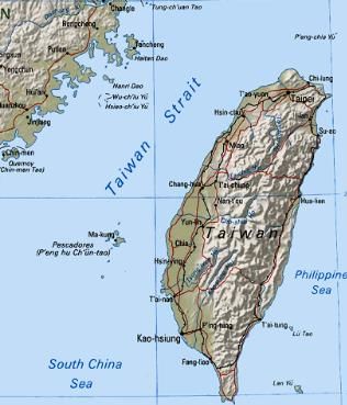
The Formosa Strait also known as Taiwan Strait connects which of the following seas?- a)East China Sea with South China Sea
- b)Yellow Sea with Sea of Japan
- c)Sea of Okhotsk with Sea of Japan
- d)South China Sea with Pacifi c Ocean
Correct answer is option 'A'. Can you explain this answer?
The Formosa Strait also known as Taiwan Strait connects which of the following seas?
a)
East China Sea with South China Sea
b)
Yellow Sea with Sea of Japan
c)
Sea of Okhotsk with Sea of Japan
d)
South China Sea with Pacifi c Ocean
| | Jaya Nair answered |
Option (a) is the correct answer: Formosa Strait connects East China Sea with South China Sea.
Taiwan Strait
Consider the following statements about Industrial Corridors in India,- Of the 11 Industrial corridors launched by the Government of India, only one of them passes through Chhattisgarh.
- Of the 11 Industrial Corridors launched by the Government, one of them lies in North Eastern India.
Which of the statements given above is/are correct?- a)1 only
- b)2 only
- c)Both 1 and 2
- d)Neither 1 nor 2
Correct answer is option 'D'. Can you explain this answer?
Consider the following statements about Industrial Corridors in India,
- Of the 11 Industrial corridors launched by the Government of India, only one of them passes through Chhattisgarh.
- Of the 11 Industrial Corridors launched by the Government, one of them lies in North Eastern India.
Which of the statements given above is/are correct?
a)
1 only
b)
2 only
c)
Both 1 and 2
d)
Neither 1 nor 2
| | Debanshi Desai answered |
Explanation:
To answer this question, we need to analyze each statement individually.
Statement 1: Of the 11 Industrial corridors launched by the Government of India, only one of them passes through Chhattisgarh.
This statement is incorrect. The Government of India has launched several industrial corridors to promote economic development and investment in various regions of the country. These corridors are planned to connect major cities and industrial clusters, thereby boosting industrial growth and creating employment opportunities.
Chhattisgarh, being a mineral-rich state with significant industrial potential, is strategically located and has been included in multiple industrial corridors. The state falls under the influence of the Delhi-Mumbai Industrial Corridor (DMIC), which is one of the most important industrial corridors in India. The DMIC passes through multiple states, including Chhattisgarh, and aims to develop industrial zones, smart cities, and infrastructure along its route.
Therefore, statement 1 is incorrect as more than one industrial corridor passes through Chhattisgarh.
Statement 2: Of the 11 Industrial Corridors launched by the Government, one of them lies in North Eastern India.
This statement is also incorrect. The Government of India has indeed recognized the potential for economic development in the North Eastern region and has taken various initiatives to promote industrial growth in the area. However, as of now, there is no specific industrial corridor exclusively dedicated to the North Eastern region.
There have been proposals and discussions about developing an industrial corridor in the North Eastern region, but it has not been officially launched or implemented yet. The government has focused on improving connectivity, infrastructure, and promoting investments in the North Eastern region to boost industrial development.
Therefore, statement 2 is also incorrect as there is no currently established industrial corridor in the North Eastern region of India.
Hence, both statements 1 and 2 are incorrect, and the correct answer is option D) Neither 1 nor 2.
What is the correct sequence of occurrence of the following Island Countries from north to south?- Cape Verde
- Sao Tome & Principe
- Comoros
- Mauritius
Select the correct answer using the code given below.- a)4-2-1-3
- b)1-2-3-4
- c)3-4-2-1
- d)4-3-2-1
Correct answer is option 'B'. Can you explain this answer?
What is the correct sequence of occurrence of the following Island Countries from north to south?
- Cape Verde
- Sao Tome & Principe
- Comoros
- Mauritius
Select the correct answer using the code given below.
a)
4-2-1-3
b)
1-2-3-4
c)
3-4-2-1
d)
4-3-2-1
| | Poonam Reddy answered |
Option b is the correct: sequence starting from north to south.
Consider the following islands:- Paracel Islands
- Pratas Islands
- Spratly Islands
- Senkaku Islands
If one is travelling from South China Sea to East China Sea, arrange the following islands one will encounter in sequential order and select the correct option from the codes given below:- a)3-1-2-4
- b)4-2-1-3
- c)4-1-3-2
- d)3-2-4-1
Correct answer is option 'A'. Can you explain this answer?
Consider the following islands:
- Paracel Islands
- Pratas Islands
- Spratly Islands
- Senkaku Islands
If one is travelling from South China Sea to East China Sea, arrange the following islands one will encounter in sequential order and select the correct option from the codes given below:
a)
3-1-2-4
b)
4-2-1-3
c)
4-1-3-2
d)
3-2-4-1
| | Arindam Mukherjee answered |
To determine the correct order of the islands one will encounter when traveling from the South China Sea to the East China Sea, let's analyze the locations of each of the islands.
1. Paracel Islands: The Paracel Islands are located in the South China Sea, specifically between Vietnam and China. They are closer to the mainland compared to the other islands.
2. Pratas Islands: The Pratas Islands, also known as the Dongsha Islands, are situated in the northern part of the South China Sea. They are closer to Taiwan than to the mainland.
3. Spratly Islands: The Spratly Islands are a group of islands located in the southern part of the South China Sea. They are further south compared to the Paracel and Pratas Islands.
4. Senkaku Islands: The Senkaku Islands, also known as the Diaoyu Islands, are located in the East China Sea. They are northeast of Taiwan and northwest of the Ryukyu Islands.
Now, let's analyze the given options:
a) 3-1-2-4: According to this option, the order would be Spratly Islands, Paracel Islands, Pratas Islands, and Senkaku Islands. This order is incorrect because the Pratas Islands are located between the Paracel and Spratly Islands, not after them.
b) 4-2-1-3: According to this option, the order would be Senkaku Islands, Pratas Islands, Paracel Islands, and Spratly Islands. This order is incorrect because it starts with the Senkaku Islands in the East China Sea, whereas the journey begins in the South China Sea.
c) 4-1-3-2: According to this option, the order would be Senkaku Islands, Paracel Islands, Spratly Islands, and Pratas Islands. This order is incorrect because it places the Spratly Islands before the Pratas Islands.
d) 3-2-4-1: According to this option, the order would be Spratly Islands, Pratas Islands, Senkaku Islands, and Paracel Islands. This order is correct because it starts with the Spratly Islands in the South China Sea, followed by the Pratas Islands, then the Senkaku Islands in the East China Sea, and finally the Paracel Islands.
Therefore, the correct answer is option 'A' (3-1-2-4).
Travelling from west to east, arrange the following capital cities in sequential order:- Riyadh
- Ankara
- Damascus
- Tehran
- Kuwait City
Select the correct option from the codes given below:- a)3-1-4-2-5
- b)2-3-1-5-4
- c)4-2-3-1-5
- d)2-1-5-3-4
Correct answer is option 'B'. Can you explain this answer?
Travelling from west to east, arrange the following capital cities in sequential order:
- Riyadh
- Ankara
- Damascus
- Tehran
- Kuwait City
Select the correct option from the codes given below:
a)
3-1-4-2-5
b)
2-3-1-5-4
c)
4-2-3-1-5
d)
2-1-5-3-4
| | Bhaskar Datta answered |
Travelling from west to east, the sequential order of the given capital cities is as follows:
1. Ankara
2. Damascus
3. Tehran
4. Kuwait City
5. Riyadh
Explanation:
Ankara: Ankara is the capital city of Turkey, which is located in the western part of Asia. Therefore, it is the first city in the sequence when traveling from west to east.
Damascus: Damascus is the capital city of Syria, which is located slightly east of Turkey. Hence, it comes after Ankara in the sequence.
Tehran: Tehran is the capital city of Iran, which is located east of Syria. Therefore, it follows Damascus in the sequence.
Kuwait City: Kuwait City is the capital city of Kuwait, which is located further east of Iran. Hence, it comes after Tehran in the sequence.
Riyadh: Riyadh is the capital city of Saudi Arabia, which is located in the easternmost part of the given cities. Therefore, it is the last city in the sequence when traveling from west to east.
Final Sequence:
The correct sequential order of the capital cities when traveling from west to east is:
2-3-1-5-4, which corresponds to Ankara, Damascus, Tehran, Kuwait City, and Riyadh, respectively.
Which of the following World Heritage Sites of South America are situated in Peru?- Chan Chan
- Cuzco
- Galapagos Islands
- Machu Picchu
Select the correct option from the codes given below:- a)1 and 2 only
- b)3 and 4 only
- c)1, 2 and 4 only
- d)1 and 3 only
Correct answer is option 'C'. Can you explain this answer?
Which of the following World Heritage Sites of South America are situated in Peru?
- Chan Chan
- Cuzco
- Galapagos Islands
- Machu Picchu
Select the correct option from the codes given below:
a)
1 and 2 only
b)
3 and 4 only
c)
1, 2 and 4 only
d)
1 and 3 only
| | Deepak Kapoor answered |
Galapagos Island is in Ecuador. Rest all are in Peru.
Which of the following countries are the part of Alps Mountain ranges..- Austria
- France
- Germany
- Monaco
- Spain
Select the correct answer using the code given below.- a)2, 3 and 4 only.
- b)1,2,3 and 4 only
- c)1,4 and 5 only.
- d)1,2,3,4 and 5 only
Correct answer is option 'B'. Can you explain this answer?
Which of the following countries are the part of Alps Mountain ranges..
- Austria
- France
- Germany
- Monaco
- Spain
Select the correct answer using the code given below.
a)
2, 3 and 4 only.
b)
1,2,3 and 4 only
c)
1,4 and 5 only.
d)
1,2,3,4 and 5 only
| | Muskaan Patel answered |
The correct answer is option 'B' - 1, 2, 3, and 4 only.
The Alps Mountain range is one of the most famous and extensive mountain ranges in Europe. It stretches across several countries and covers a significant part of the continent. Let's analyze each country mentioned in the options to determine if they are part of the Alps.
1. Austria:
Austria is indeed part of the Alps Mountain range. The Austrian Alps cover a large portion of the country, with stunning peaks and picturesque landscapes. Some of the famous mountain ranges in Austria include the Hohe Tauern, the Ötztal Alps, and the Zillertal Alps.
2. France:
France is another country that is included in the Alps Mountain range. The French Alps are renowned for their beauty and are a major tourist attraction. Mont Blanc, the highest peak in the Alps and Western Europe, is located in the French Alps. Other notable mountain ranges in France include the Vanoise Massif and the Ecrins Massif.
3. Germany:
Contrary to popular belief, Germany is not part of the Alps Mountain range. The mountain ranges in Germany are the Central Uplands, which are distinct from the Alps. The highest peak in Germany, the Zugspitze, is located in the Bavarian Alps, but these mountains are considered a separate range from the main Alps.
4. Monaco:
Monaco is a small city-state located on the French Riviera and is not part of the Alps Mountain range. It is situated on the Mediterranean coast and does not have any significant mountain ranges within its borders.
5. Spain:
Spain, specifically the Iberian Peninsula, is not part of the Alps Mountain range. Spain has its own mountain ranges, such as the Pyrenees in the northeast and the Sierra Nevada in the south, but these are separate from the Alps.
In conclusion, the countries that are part of the Alps Mountain range are Austria (1), France (2), and Germany (3). Therefore, the correct answer is option 'B' - 1, 2, 3, and 4 only.
Black sea is the border of which of the following European countries?- Turkey
- Bulgaria
- Romania
- Ukraine
- Georgia
Which of the pairs given above are correctly matched?- a)1,2,3,4 and 5 only
- b)1,3 and 4 only
- c)1,2, 4 and 5 only
- d)1,2,3 and 4 only
Correct answer is option 'A'. Can you explain this answer?
Black sea is the border of which of the following European countries?
- Turkey
- Bulgaria
- Romania
- Ukraine
- Georgia
Which of the pairs given above are correctly matched?
a)
1,2,3,4 and 5 only
b)
1,3 and 4 only
c)
1,2, 4 and 5 only
d)
1,2,3 and 4 only
| | Kavita Shah answered |
The Black Sea is the border of all the European countries listed above:
1. Turkey: The Black Sea lies to the north of Turkey, providing a natural border and a significant coastline.
2. Bulgaria: The eastern border of Bulgaria is the Black Sea, offering a coastline that attracts tourists to its beaches.
3. Romania: Romania shares its eastern border with the Black Sea, with important ports like Constanta located on its coast.
4. Ukraine: The southern border of Ukraine is the Black Sea, which provides the country with valuable access to maritime trade.
5. Georgia: Georgia, although located at the intersection of Eastern Europe and Western Asia, is considered part of Europe, and its western border is the Black Sea.
So, all the pairs given above are correctly matched.
Which of the following is correctthe Stone Age sites in India?- Belan Valley in UP is an important Paleolithic site that shows the evidence of cattle exploitation.
- Bogar in Rajasthan, a Neolithic site, was a distinctive microlith industry.
- Maski, Brahmagiri and Hallur are important Neolithic sites in Karnataka.
Select the correct option using the codes given below-- a)1 and 2 only
- b)2 and 3 only
- c)1 and 3 only
- d)1, 2 and 3
Correct answer is option 'C'. Can you explain this answer?
Which of the following is correctthe Stone Age sites in India?
- Belan Valley in UP is an important Paleolithic site that shows the evidence of cattle exploitation.
- Bogar in Rajasthan, a Neolithic site, was a distinctive microlith industry.
- Maski, Brahmagiri and Hallur are important Neolithic sites in Karnataka.
Select the correct option using the codes given below-
a)
1 and 2 only
b)
2 and 3 only
c)
1 and 3 only
d)
1, 2 and 3
| | Rahul Choudhury answered |
- Statement 2 is incorrect, so usning elimination method one can arrive at the correct answer which is option (c).
- Statement 2 is incorrect: Bogar in Rajasthan, a Mesolithic site, was a distinctive microlith industry.
Which one territory of the following was not a part of Ashoka’s empire?- a)Afghanistan
- b)Bihar
- c)Sri Lanka
- d)Kalinga
Correct answer is option 'C'. Can you explain this answer?
Which one territory of the following was not a part of Ashoka’s empire?
a)
Afghanistan
b)
Bihar
c)
Sri Lanka
d)
Kalinga
| | Palak Pillai answered |
The territory that was not a part of Ashoka's empire is Ceylon (modern-day Sri Lanka).
Arrange the following seas in north to south order:- East China Sea
- Yellow Sea
- Sea of Okhotsk
- Philippines Sea
Select the correct option from the codes given below:- a)2-4-3-1
- b)3-4-2-1
- c)3-2-1-4
- d)1-3-4-2
Correct answer is option 'C'. Can you explain this answer?
Arrange the following seas in north to south order:
- East China Sea
- Yellow Sea
- Sea of Okhotsk
- Philippines Sea
Select the correct option from the codes given below:
a)
2-4-3-1
b)
3-4-2-1
c)
3-2-1-4
d)
1-3-4-2
| | Deepa Iyer answered |
Option (c) is correct: Sea of Okhotsk-Yellow Sea-East China Sea-Philippines Sea
Arrange the following Gulfs in east to west order:- Gulf of Oman
- Gulf of Aden
- Gulf of Thailand
- Persian Gulf
Select the correct option from the codes given below:- a)1-3-2-4
- b)3-4-1-2
- c)3-1-4-2
- d)3-1-2-4
Correct answer is option 'C'. Can you explain this answer?
Arrange the following Gulfs in east to west order:
- Gulf of Oman
- Gulf of Aden
- Gulf of Thailand
- Persian Gulf
Select the correct option from the codes given below:
a)
1-3-2-4
b)
3-4-1-2
c)
3-1-4-2
d)
3-1-2-4
| | Krithika Joshi answered |
Order of Gulfs from East to West
Introduction:
This question is related to the geographical location of different gulfs in Asia. The candidate needs to arrange the given gulfs in the correct order from east to west.
Explanation:
The correct order of the given gulfs from east to west is as follows:
1. Gulf of Thailand: This gulf is located in the eastern part of the Indian Ocean and is bordered by Thailand, Cambodia, and Vietnam.
2. Gulf of Aden: This gulf is located in the western part of the Indian Ocean and is bordered by Yemen, Somalia, and Djibouti.
3. Persian Gulf: This gulf is located in the Middle East and is bordered by Iran, Iraq, Kuwait, Saudi Arabia, Bahrain, Qatar, and the United Arab Emirates.
4. Gulf of Oman: This gulf is located in the Arabian Sea and is bordered by Iran, Pakistan, Oman, and the United Arab Emirates.
Therefore, the correct order of the given gulfs from east to west is 3-1-4-2.
Conclusion:
In this question, the candidate needed to have basic knowledge of the geographical locations of different gulfs in Asia. By following the given instructions, the candidate can easily come up with the correct answer.
Red Sea is bordered by which of the following African countries?- Egypt
- Sudan
- Yemen
- Ethiopia
- Eritrea
Which of the pairs given above are correctly matched?- a)1,2,3 and 4 only
- b)1,4 and 5 only
- c)1,2 and 5 only
- d)1,2,3,4 and 5 only
Correct answer is option 'C'. Can you explain this answer?
Red Sea is bordered by which of the following African countries?
- Egypt
- Sudan
- Yemen
- Ethiopia
- Eritrea
Which of the pairs given above are correctly matched?
a)
1,2,3 and 4 only
b)
1,4 and 5 only
c)
1,2 and 5 only
d)
1,2,3,4 and 5 only
| | Farida Ali answered |
From African side four countries touch Red sea Egypt, Sudan, Eritrea and Djibouti
If one is travelling from Somalia to Philippines via sea route along coastline, arrange the following islands one will encounter in sequential order:- Phuket Island
- Socotra Island
- Borneo Island
- Sumatra Island
Select the correct option from the codes given below:- a)1-2-3-4
- b)2-1-4-3
- c)3-4-2-1
- d)1-2-4-3
Correct answer is option 'B'. Can you explain this answer?
If one is travelling from Somalia to Philippines via sea route along coastline, arrange the following islands one will encounter in sequential order:
- Phuket Island
- Socotra Island
- Borneo Island
- Sumatra Island
Select the correct option from the codes given below:
a)
1-2-3-4
b)
2-1-4-3
c)
3-4-2-1
d)
1-2-4-3
| | Jhanvi Rane answered |
Sequence of Islands from Somalia to Philippines via Sea Route
The correct sequence of islands one will encounter while travelling from Somalia to Philippines via sea route along the coastline is:
1. Socotra Island
2. Phuket Island
3. Borneo Island
4. Sumatra Island
Explanation:
- Socotra Island: It is located off the coast of Somalia and is the first island one will encounter while travelling from Somalia to Philippines along the coastline.
- Phuket Island: It is located in Thailand and is the second island one will encounter while travelling from Somalia to Philippines along the coastline.
- Borneo Island: It is located in Southeast Asia and is the third island one will encounter while travelling from Somalia to Philippines along the coastline.
- Sumatra Island: It is located in Indonesia and is the fourth and final island one will encounter while travelling from Somalia to Philippines along the coastline.
Therefore, the correct sequence of islands from Somalia to Philippines via sea route along the coastline is 2-1-4-3, which is option B.
Golan Heights touches the boundary of which of the following countries?- Syria
- Jordan
- Lebanon
- Egypt
- Israel
Select the correct option from the codes given below:- a)1, 2, 3 , 4 and 5
- b)1, 2, 4 and 5 only
- c)1, 2, 3 and 5 only
- d)1, 3 and 5 only
Correct answer is option 'C'. Can you explain this answer?
Golan Heights touches the boundary of which of the following countries?
- Syria
- Jordan
- Lebanon
- Egypt
- Israel
Select the correct option from the codes given below:
a)
1, 2, 3 , 4 and 5
b)
1, 2, 4 and 5 only
c)
1, 2, 3 and 5 only
d)
1, 3 and 5 only
| | Jaya Nair answered |
It touches the boundary of Syria, Jordan, Lebanon and Israel.
Consider the following statements:- Ladakh Plateau is situated between Karakoram and Himalaya mountain ranges.
- Tibetan Plateau is situated between Kulun and Himalayan Mountain range.
- Armenian Plateau is bordered by Caspian and the Black Sea.
Which of the above statement/s is/are correct?- a)1 and 2 only
- b)2 only
- c)1 and 3 only
- d)1, 2 and 3
Correct answer is option 'D'. Can you explain this answer?
Consider the following statements:
- Ladakh Plateau is situated between Karakoram and Himalaya mountain ranges.
- Tibetan Plateau is situated between Kulun and Himalayan Mountain range.
- Armenian Plateau is bordered by Caspian and the Black Sea.
Which of the above statement/s is/are correct?
a)
1 and 2 only
b)
2 only
c)
1 and 3 only
d)
1, 2 and 3
| | Arindam Mukherjee answered |
The correct answer is option D: 1, 2, and 3.
Let's look at each statement individually to understand why they are correct:
1) Ladakh Plateau is situated between Karakoram and Himalaya mountain ranges.
The Ladakh Plateau is indeed situated between the Karakoram and Himalaya mountain ranges. It is located in the northern part of India, in the union territory of Ladakh. The Karakoram range lies to the north of the plateau, while the Himalayas lie to the south. This geographical location makes Ladakh a region of high altitude and rugged terrain.
2) Tibetan Plateau is situated between Kulun and Himalayan Mountain range.
The second statement is incorrect. The Tibetan Plateau is not situated between Kulun and the Himalayan Mountain range. The correct statement should be that the Tibetan Plateau is situated between the Kunlun Mountains to the north and the Himalayas to the south. The Kunlun Mountains are a major mountain range in China, while the Himalayas are a vast mountain range spanning several countries including India, Nepal, Bhutan, and Tibet.
3) Armenian Plateau is bordered by Caspian and the Black Sea.
The third statement is correct. The Armenian Plateau is indeed bordered by the Caspian Sea to the east and the Black Sea to the west. The Armenian Plateau is a large plateau located in the South Caucasus region, covering parts of Armenia, Georgia, and Turkey. The Caspian Sea is the largest inland body of water in the world and is located to the east of the Armenian Plateau, while the Black Sea is located to the west.
In conclusion, the correct statements are 1) Ladakh Plateau is situated between Karakoram and Himalaya mountain ranges, 2) Tibetan Plateau is situated between Kunlun and Himalayan Mountain range, and 3) Armenian Plateau is bordered by Caspian and the Black Sea. Therefore, the correct answer is option D: 1, 2, and 3.
Consider the following statements regarding the Drake Passage:- The Drake Passage is the longest distance between Antarctica and other continents.
- This Passage is located between Cape Horn at the tip of South America and the Antarctic Peninsula.
- It is the narrowest stretch in the Southern Ocean and spans approximately 800 km.
Which of the above statement/s is/are correct?- a)1 and 2 only
- b)2 and 3 only
- c)1 only
- d)3 only
Correct answer is option 'B'. Can you explain this answer?
Consider the following statements regarding the Drake Passage:
- The Drake Passage is the longest distance between Antarctica and other continents.
- This Passage is located between Cape Horn at the tip of South America and the Antarctic Peninsula.
- It is the narrowest stretch in the Southern Ocean and spans approximately 800 km.
Which of the above statement/s is/are correct?
a)
1 and 2 only
b)
2 and 3 only
c)
1 only
d)
3 only
| | Meera Kapoor answered |
The Drake Passage is the shortest distance between Antarctica and other continents.
What is the correct sequence of occurrence of the following water bodies from south to north?- Gulf of Bothnia
- Sea of Azov
- Adriatic Sea
- Ionian Sea
Select the correct answer using the code given below.- a)1-2-3-4
- b)4-2-1-3
- c)3-4-2-1
- d)4-3-2-1
Correct answer is option 'D'. Can you explain this answer?
What is the correct sequence of occurrence of the following water bodies from south to north?
- Gulf of Bothnia
- Sea of Azov
- Adriatic Sea
- Ionian Sea
Select the correct answer using the code given below.
a)
1-2-3-4
b)
4-2-1-3
c)
3-4-2-1
d)
4-3-2-1
| | Pooja Choudhury answered |
Option d is the correct sequence starting from south to north.
Water Bodies of Europe
- The Gulf of Bothnia is the northernmost part of the Baltic Sea. The Geographical Location is between Finland’s west coast and Sweden’s east coast.
- The Sea of Azov which is bounded by Ukraine and Russia in the Eastern Europe is connected to the Black Sea by the narrow Strait of Kerch. The Don and Kuban are the major rivers that fl ow into it.
- The Adriatic Sea is the northernmost part of the Mediterranean Sea. The countries with coasts on the Adriatic are Albania, Bosnia and Herzegovina, Croatia, Italy, Montenegro and Slovenia.
- The Ionian Sea is an elongated bay of the Mediterranean Sea, which falls south of the Adriatic Sea and is bounded by Italy , Albania, and Greece.
Arrange the following capital cities of South American countries in North to South order:- Brasilia
- Lima
- Montevideo
- Santiago
Select the correct option from the codes given below:- a)2-1-4-3
- b)1-2-3-4
- c)1-2-4-3
- d)4-3-1-2
Correct answer is option 'A'. Can you explain this answer?
Arrange the following capital cities of South American countries in North to South order:
- Brasilia
- Lima
- Montevideo
- Santiago
Select the correct option from the codes given below:
a)
2-1-4-3
b)
1-2-3-4
c)
1-2-4-3
d)
4-3-1-2
| | Aravind Menon answered |
The correct order of the capital cities of South American countries in North to South order is: Brasilia, Lima, Montevideo, Santiago. Let's understand why option 'A' is the correct answer.
1. Brasilia:
Brasilia is the capital city of Brazil, which is the largest country in South America. It is located in the central part of Brazil, near the country's geographical center.
2. Lima:
Lima is the capital city of Peru, which is located on the western coast of South America. It is situated in the central part of Peru, along the Pacific Ocean.
3. Montevideo:
Montevideo is the capital city of Uruguay, which is located in the southeastern part of South America. It is situated on the east coast of Uruguay, along the Atlantic Ocean.
4. Santiago:
Santiago is the capital city of Chile, which is located in the southwestern part of South America. It is situated in the central valley of Chile, surrounded by the Andes Mountains.
Now let's analyze the given options:
a) 2-1-4-3:
According to this option, the order would be Lima, Brasilia, Santiago, Montevideo. However, this is not the correct order as Brasilia should come before Lima.
b) 1-2-3-4:
According to this option, the order would be Brasilia, Lima, Montevideo, Santiago. This is the correct order as it follows the North to South arrangement.
c) 1-2-4-3:
According to this option, the order would be Brasilia, Lima, Santiago, Montevideo. This is not the correct order as Montevideo should come after Santiago.
d) 4-3-1-2:
According to this option, the order would be Santiago, Montevideo, Brasilia, Lima. This is not the correct order as Lima should come before Brasilia.
Therefore, the correct option is 'b' which represents the North to South order of the capital cities of South American countries: Brasilia, Lima, Montevideo, Santiago.
The Rust Belt is a region that coincides with:- a)An area of soils with a high concentration of iron.
- b)An iron ore mining area in northern Minnesota.
- c)A former area of predominantly steel and automobile manufacturing within the American Manufacturing belt.
- d)The industrial cities in the rugged lands of the far West.
Correct answer is option 'C'. Can you explain this answer?
The Rust Belt is a region that coincides with:
a)
An area of soils with a high concentration of iron.
b)
An iron ore mining area in northern Minnesota.
c)
A former area of predominantly steel and automobile manufacturing within the American Manufacturing belt.
d)
The industrial cities in the rugged lands of the far West.
| | Deepak Kapoor answered |
This region was dominated by the manufacturing of steel. It is now characterized by old steel mills.
Which of the following statement is/are correct?- Manchurian Plain- formed by the Amur River
- Turanian Plain-formed by the two Asian Rivers. the Amu Darya and Syr Darya
- Aral Sea- Located between Kazakhstan and China
Select the correct code from below.- a)Both 1 and 2
- b)Only 3
- c)1 and 3
- d)All of the above
Correct answer is option 'A'. Can you explain this answer?
Which of the following statement is/are correct?
- Manchurian Plain- formed by the Amur River
- Turanian Plain-formed by the two Asian Rivers. the Amu Darya and Syr Darya
- Aral Sea- Located between Kazakhstan and China
Select the correct code from below.
a)
Both 1 and 2
b)
Only 3
c)
1 and 3
d)
All of the above
 | Malavika Rane answered |
The correct answer is option 'A' - Both 1 and 2.
1. Manchurian Plain - formed by the Amur River:
The Manchurian Plain is a vast lowland region located in northeastern China and southeastern Russia. It is formed by the Amur River, which flows through the region. The Amur River is one of the major rivers in Asia, originating in the mountains of northeastern China and flowing along the border between China and Russia. The river is known for its significant influence on the geography and climate of the Manchurian Plain.
2. Turanian Plain - formed by the two Asian Rivers, the Amu Darya and Syr Darya:
The Turanian Plain, also known as the Central Asian Plain, is a large lowland region located in Central Asia. It is formed by the two major rivers, the Amu Darya and Syr Darya. The Amu Darya and Syr Darya are both significant rivers in Central Asia, originating in the Pamir and Tian Shan mountains respectively. They flow through several countries, including Afghanistan, Tajikistan, Uzbekistan, and Kazakhstan. These rivers have played a crucial role in shaping the geography and providing water resources to the Turanian Plain.
3. Aral Sea - Located between Kazakhstan and China:
This statement is incorrect. The Aral Sea is actually located between Kazakhstan and Uzbekistan, not China. The Aral Sea was once one of the largest inland seas in the world, but due to excessive irrigation for agriculture and the diversion of its inflowing rivers, it has significantly shrunk in size over the years. The ecological and environmental consequences of the shrinking of the Aral Sea have been severe, including the loss of biodiversity and the emergence of a dust and salt storm problem in the region.
In summary, the correct statements are:
- The Manchurian Plain is formed by the Amur River.
- The Turanian Plain is formed by the two Asian Rivers, the Amu Darya and Syr Darya.
The incorrect statement is:
- The Aral Sea is located between Kazakhstan and China.
Consider the following:- Gulf of Mannar
- Strait of Hormuz
- Gulf of Aden
- Persian Gulf
Which of the following lies above the Tropic of Cancer?- a)1 and 3 only
- b)2 and 4 only
- c)1 and 4 only
- d)2, 3 and 4 only
Correct answer is option 'B'. Can you explain this answer?
Consider the following:
- Gulf of Mannar
- Strait of Hormuz
- Gulf of Aden
- Persian Gulf
Which of the following lies above the Tropic of Cancer?
a)
1 and 3 only
b)
2 and 4 only
c)
1 and 4 only
d)
2, 3 and 4 only
| | Shruti Bajaj answered |
Geography of the given water bodies:
- Gulf of Mannar: Located between India and Sri Lanka, in the Indian Ocean.
- Strait of Hormuz: Located between Iran and Oman, connecting the Persian Gulf and the Gulf of Oman.
- Gulf of Aden: Located between Yemen and Somalia, in the Arabian Sea.
- Persian Gulf: Located between Iran and the Arabian Peninsula.
Location above Tropic of Cancer:
- Gulf of Mannar: Lies south of the Tropic of Cancer.
- Strait of Hormuz: Lies south of the Tropic of Cancer.
- Gulf of Aden: Lies north of the Tropic of Cancer.
- Persian Gulf: Lies north of the Tropic of Cancer.
Therefore, only the Strait of Hormuz and the Persian Gulf lie above the Tropic of Cancer, making option B the correct answer.
Consider the following statements regarding Sinai Peninsula:- Sinai Peninsula located in the Asian part of Egypt between the Mediterranean Sea to the north, and the Red Sea to the south.
- It shares maritime or territorial boundary with Israel, Jordan and Gaza Strip.
Which of the above statement/s is/are correct?- a)1 only
- b)2 only
- c)Both 1 and 2
- d)Neither 1 nor 2
Correct answer is option 'C'. Can you explain this answer?
Consider the following statements regarding Sinai Peninsula:
- Sinai Peninsula located in the Asian part of Egypt between the Mediterranean Sea to the north, and the Red Sea to the south.
- It shares maritime or territorial boundary with Israel, Jordan and Gaza Strip.
Which of the above statement/s is/are correct?
a)
1 only
b)
2 only
c)
Both 1 and 2
d)
Neither 1 nor 2
| | Niharika Shah answered |
Sinai Peninsula
Statement 1: Sinai Peninsula located in the Asian part of Egypt between the Mediterranean Sea to the north, and the Red Sea to the south.
This statement is correct. The Sinai Peninsula is a triangular peninsula in Egypt that is situated in the Asian part of the country. It is bordered by the Mediterranean Sea to the north, the Red Sea to the south, and the Suez Canal to the west.
Statement 2: It shares maritime or territorial boundary with Israel, Jordan and Gaza Strip.
This statement is also correct. The Sinai Peninsula shares a border with Israel to the east, the Gaza Strip to the northeast, and Jordan to the east and south.
Therefore, both statements are correct.
Conclusion
The Sinai Peninsula is a triangular peninsula in Egypt that is bordered by the Mediterranean Sea to the north, the Red Sea to the south, and the Suez Canal to the west. It shares borders with Israel to the east, the Gaza Strip to the northeast, and Jordan to the east and south.
Consider the following facts:- It is the highest navigable lake in the world.
- 60% of the lake is located in Peru whilst the remaining 40% belong to Bolivia
- It is a monomictic lake, with only 1 season of free circulation.
The above facts describe which of the following lakes?- a)Viedma Lake
- b)Lake Titicaca
- c)Lake Tanganyika
- d)Mar Chiquita Lake
Correct answer is option 'B'. Can you explain this answer?
Consider the following facts:
- It is the highest navigable lake in the world.
- 60% of the lake is located in Peru whilst the remaining 40% belong to Bolivia
- It is a monomictic lake, with only 1 season of free circulation.
The above facts describe which of the following lakes?
a)
Viedma Lake
b)
Lake Titicaca
c)
Lake Tanganyika
d)
Mar Chiquita Lake
| | Sanjay Rana answered |
Lake Titicaca
- Often referred to as the highest navigable lake in the world, Lake Titicaca is located at an altitude of 3,812 meters and it is the largest lake by volume in South America.
- 60% of the lake is located in Peru (the western part), whilst the remaining 40% belong to Bolivia (the eastern end).
- The lake is made up of two large basins which are connected by the Strait of Tiquina.
- The Lake Titicaca Reserve was created in 1978 in aim of preserving the special fauna, fl ora and the unique countryside found here.
- Monomictic lake: Monomictic lakes are holomictic (uniform temperature and density from top to bottom) lakes that mix from top to bottom during one mixing period each year. Monomictic lakes may be subdivided into cold and warm types. Lake Titicaca is a monomictic lake.
From the excavations of which ancient site, information has been gathered regarding brisk trade relations between India and Rome, during the early centuries of Christian era :- a)Madurai
- b)Tamralipti
- c)Tondi
- d)Arikamedu
Correct answer is option 'D'. Can you explain this answer?
From the excavations of which ancient site, information has been gathered regarding brisk trade relations between India and Rome, during the early centuries of Christian era :
a)
Madurai
b)
Tamralipti
c)
Tondi
d)
Arikamedu
| | Srestha Banerjee answered |
Excavations at Arikamedu have provided information about trade relations between India and Rome during the early centuries of the Christian era. Arikamedu was an ancient port city located on the southeastern coast of India, near modern-day Puducherry.
Evidence of Trade Relations:
• Arikamedu was a major center for the trade of beads, gems, and other luxury items. Archaeological excavations have unearthed a large number of Roman and West Asian artifacts, including pottery, coins, and glassware.
• The discovery of Roman pottery at Arikamedu suggests that the Romans were actively engaged in trade with India during this time.
• The presence of Indian artifacts in Rome, such as Indian textiles and spices, further corroborates the existence of trade relations between the two regions.
• The port of Arikamedu was also an important center for the trade of spices, particularly black pepper.
• The discovery of Roman coins at Arikamedu suggests that the Romans were paying for their Indian imports with Roman currency.
Conclusion:
In conclusion, the excavations at Arikamedu have provided valuable insights into the trade relations between India and Rome during the early centuries of the Christian era. The port city was a major center for the trade of luxury items, spices, and other goods, and evidence of Roman artifacts in India and Indian artifacts in Rome suggests a significant degree of commercial exchange between the two regions.
Consider the following:- Canaima National Park
- Angel Falls
- Nazca Lines
- Lake Maracaibo
Which of the following is/are present in/a part of Venezuela?- a)All of the above
- b)2, 3 and 4 only
- c)1, 2 and 4 only
- d)1, 3and 4 only
Correct answer is option 'C'. Can you explain this answer?
Consider the following:
- Canaima National Park
- Angel Falls
- Nazca Lines
- Lake Maracaibo
Which of the following is/are present in/a part of Venezuela?
a)
All of the above
b)
2, 3 and 4 only
c)
1, 2 and 4 only
d)
1, 3and 4 only
| | Simran Menon answered |
Overview of Locations
Venezuela is home to some remarkable natural and cultural landmarks. In this case, we analyze four notable sites: Canaima National Park, Angel Falls, Nazca Lines, and Lake Maracaibo.
Canaima National Park
- Canaima National Park is located in Venezuela and is famous for its stunning landscapes, including table-top mountains known as "tepuis."
- It is a UNESCO World Heritage Site and covers an area of approximately 30,000 square kilometers.
Angel Falls
- Angel Falls, the world's highest uninterrupted waterfall, is situated within Canaima National Park.
- It drops a height of 979 meters and is a significant tourist attraction in Venezuela.
Nazca Lines
- The Nazca Lines are large geoglyphs located in the Nazca Desert of southern Peru.
- They are not part of Venezuela but are often confused due to their significance in South American culture.
Lake Maracaibo
- Lake Maracaibo is the largest lake in Latin America, located in northwestern Venezuela.
- It is known for its biodiversity and the unique phenomenon of Catatumbo lightning.
Correct Answer Explanation
- The correct answer is option 'C' (1, 2, and 4 only) because:
- Canaima National Park and Angel Falls are both in Venezuela.
- Lake Maracaibo is also in Venezuela.
- However, the Nazca Lines are not located in Venezuela; they are found in Peru.
Thus, options 1, 2, and 4 are present in or part of Venezuela, confirming that the answer is indeed 'C'.
Consider the following statements- It is the longest river in Africa and its basin is popular for cotton cultivation since ancient time
- The river Nile has two major tributaries the White Nile and the Blue Nile of which the White Nile emerges from Lake Victoria.
- Blue Nile emerges from Euthopian Highlands.
Select the correct answer using the code given below.- a)1 and 2 only
- b)2 and 3 only
- c)1,2 and 3
- d)None of the above
Correct answer is option 'C'. Can you explain this answer?
Consider the following statements
- It is the longest river in Africa and its basin is popular for cotton cultivation since ancient time
- The river Nile has two major tributaries the White Nile and the Blue Nile of which the White Nile emerges from Lake Victoria.
- Blue Nile emerges from Euthopian Highlands.
Select the correct answer using the code given below.
a)
1 and 2 only
b)
2 and 3 only
c)
1,2 and 3
d)
None of the above
| | Anjana Datta answered |
Explanation:
Longest River in Africa:
- The statement is correct. The Nile River is the longest river in Africa.
- It is approximately 6,650 kilometers long and flows through 11 countries.
Nile River Tributaries:
- The statement is partially correct. The Nile River has two major tributaries, the White Nile and the Blue Nile.
- The White Nile emerges from Lake Victoria, the largest lake in Africa.
- The Blue Nile, on the other hand, originates from the Ethiopian Highlands.
- The White Nile and Blue Nile meet in Sudan to form the main Nile River.
Cotton Cultivation and Nile Basin:
- The Nile Basin has been popular for cotton cultivation since ancient times.
- The fertile soil and ample water supply from the Nile River have made it an ideal region for cotton farming.
- Countries like Egypt and Sudan are known for their cotton production along the Nile.
Therefore, all three statements are correct, making option 'C' the correct answer.
The Pamir Knot is the junction of five mountain ranges. Which of the following is/are not one of them?- KunlunMountains
- Zagros Mountains
- Karakoram Mountains
- Kirthar Mountains
- Hindu Kush Mountains
Which of the following is/are not one of them?- a)4 and 5 only
- b)2 and 3 only
- c)1 and 5 only
- d)2 and 4 only
Correct answer is option 'D'. Can you explain this answer?
The Pamir Knot is the junction of five mountain ranges. Which of the following is/are not one of them?
- KunlunMountains
- Zagros Mountains
- Karakoram Mountains
- Kirthar Mountains
- Hindu Kush Mountains
Which of the following is/are not one of them?
a)
4 and 5 only
b)
2 and 3 only
c)
1 and 5 only
d)
2 and 4 only
| | Arun Khatri answered |
Option (d) is the correct answer:
Zagros Mountains and Kirthar Mountains are not one of them The Pamir Knot is the junction of five mountain ranges they are the Tien Shan, the Hindu Kush, the Kunlun, the Karakoram, and the Himalayan ranges.
Pamirs Knot The Pamirs are the most famous mountain convergence zone in the world. It is the largest mountain convergence zone. It lies in the hinterland of Eurasia and extends across China, Tajikistan and Afghanistan with an area of more than 100,000 km2. The Pamir Mountains were created by crustal tectonics. They spread from the south to the north of the Qinghai-Tibetan Plateau and converged on the Pamirs. Pamir Mountains are known as ‘The Roof of the World’. There are suture lines resulting from the collision between the Indian and Eurasian plates, which occurred at the closure of the Paleo-Tethys period.
Which of the following countries does the Prime Meridian pass?- Spain
- Algeria
- Benin
- Togo
- Ghana
Which of the pairs given above are correctly matched?- a)1, 2 and 3only.
- b)3, 4 and 5 only.
- c)1, 2, 4 and 5 only.
- d)1, 2, 3,4 and 5 only.
Correct answer is option 'C'. Can you explain this answer?
Which of the following countries does the Prime Meridian pass?
- Spain
- Algeria
- Benin
- Togo
- Ghana
Which of the pairs given above are correctly matched?
a)
1, 2 and 3only.
b)
3, 4 and 5 only.
c)
1, 2, 4 and 5 only.
d)
1, 2, 3,4 and 5 only.
| | Ishani Singh answered |
Explanation:
Prime Meridian:
- The Prime Meridian is the line of 0 degrees longitude, from which all other longitudes are measured.
- It passes through several countries as it runs from the North Pole to the South Pole.
Countries through which the Prime Meridian passes:
- Spain: The Prime Meridian passes through Spain.
- Algeria: The Prime Meridian also passes through Algeria.
- Benin: The Prime Meridian does not pass through Benin.
- Togo: The Prime Meridian does not pass through Togo.
- Ghana: The Prime Meridian also does not pass through Ghana.
Correctly matched countries:
- Spain
- Algeria
Therefore, the correctly matched countries through which the Prime Meridian passes are Spain and Algeria, which are options 1, 2, and 4, making option 'c' the correct answer.
Which of the following European countries does not open to Mediterranean Sea?- a)Italy
- b)Slovenia
- c)Hungary
- d)Albania
Correct answer is option 'C'. Can you explain this answer?
Which of the following European countries does not open to Mediterranean Sea?
a)
Italy
b)
Slovenia
c)
Hungary
d)
Albania
| | Sanjay Rana answered |
Hungary is a landlocked country of Europe.
Organize the following lakes from west to east order:- Lake Michigan
- Lake Erie
- Lake Ontario
- Lake Huron
- Lake Superior
Choose the correct option from the codes given below:- a)1-2-3-4-5
- b)3-2-5-4-1
- c)5-1-4-2-3
- d)4-3-5-1-2
Correct answer is option 'C'. Can you explain this answer?
Organize the following lakes from west to east order:
- Lake Michigan
- Lake Erie
- Lake Ontario
- Lake Huron
- Lake Superior
Choose the correct option from the codes given below:
a)
1-2-3-4-5
b)
3-2-5-4-1
c)
5-1-4-2-3
d)
4-3-5-1-2
| | Shruti Bajaj answered |
Organizing the Great Lakes from west to east:
1. Lake Superior
2. Lake Michigan
3. Lake Huron
4. Lake Erie
5. Lake Ontario
Explanation:
Lake Superior is the westernmost of the Great Lakes and is located on the border of the United States and Canada. Lake Michigan is located to the southeast of Lake Superior, and is connected to it by the Straits of Mackinac. Lake Huron is located to the east of Lake Michigan and is connected to it by the Straits of Mackinac as well as the St. Clair River. Lake Erie is located to the southeast of Lake Huron and is connected to it by the Detroit River. Finally, Lake Ontario is the easternmost of the Great Lakes and is located on the border of the United States and Canada.
Therefore, the correct order of Great Lakes from west to east is Lake Superior, Lake Michigan, Lake Huron, Lake Erie, and Lake Ontario, which corresponds to option C.
What is the correct sequence of occurrence of the following from East to West?- Grain Coast
- Gold Coast
- Ivory Coast
- Slave Coast
Select the correct answer using the code given below.- a)4-2-3-1
- b)1-2-3-4
- c)3-4-2-1
- d)4-3-2-1
Correct answer is option 'A'. Can you explain this answer?
What is the correct sequence of occurrence of the following from East to West?
- Grain Coast
- Gold Coast
- Ivory Coast
- Slave Coast
Select the correct answer using the code given below.
a)
4-2-3-1
b)
1-2-3-4
c)
3-4-2-1
d)
4-3-2-1
| | Zara Khan answered |
Option (a) is the correct: sequence starting from East to West.
Chapter doubts & questions for Prelims Based Tests - Oxford Student ATLAS: Maps & Tests 2026 is part of UPSC CSE exam preparation. The chapters have been prepared according to the UPSC CSE exam syllabus. The Chapter doubts & questions, notes, tests & MCQs are made for UPSC CSE 2026 Exam. Find important definitions, questions, notes, meanings, examples, exercises, MCQs and online tests here.
Chapter doubts & questions of Prelims Based Tests - Oxford Student ATLAS: Maps & Tests in English & Hindi are available as part of UPSC CSE exam. Download more important topics, notes, lectures and mock test series for UPSC CSE Exam by signing up for free.
Oxford Student ATLAS: Maps & Tests19 videos|105 docs|121 tests |