


All Exams > Class 9 > Social Studies (SST) Class 9 > All Questions
All questions of India - Size and Location for Class 9 Exam
Standard meridian of India is __________________.- a)82°50'E
- b)7°30'E
- c)68°7'E
- d)23°30'E
Correct answer is option 'A'. Can you explain this answer?
Standard meridian of India is __________________.
a)
82°50'E
b)
7°30'E
c)
68°7'E
d)
23°30'E
| | Gaurav Kumar answered |
The standard meridian of India is 82°30'E. It passes through Mirzapur (Uttar Pradesh). The time of this meridian is taken as the standard time for the whole country.

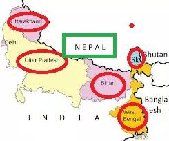
Uttarakhand, Uttar Pradesh, Bihar, West Bengal and Sikkim have a common frontier with Nepal.- a)True
- b)False
Correct answer is option 'A'. Can you explain this answer?
Uttarakhand, Uttar Pradesh, Bihar, West Bengal and Sikkim have a common frontier with Nepal.
a)
True
b)
False
 | Arizona Academy answered |
Indian states that share a border with Nepal are - Uttrakhand, Uttar Pradesh, Sikkim, West Bengal, and Bihar. The border was formed after the Treaty of Sugauly, 1816 between Nepal and the British Raj.
The state-wise length of borders are given below:
The state-wise length of borders are given below:
- Uttrakhand: 251 km
- Uttar Pradesh: 551 km
- Sikkim: 99 km
- West Bengal: 100 km
- Bihar: 726 km
Time of Arunachal Pradesh is __________________ hour ahead from Jaisalmer.- a)1
- b)2
- c)3
- d)4
Correct answer is option 'B'. Can you explain this answer?
Time of Arunachal Pradesh is __________________ hour ahead from Jaisalmer.
a)
1
b)
2
c)
3
d)
4
| | Shrushti Barure answered |
Due to the longitudinal extent there is a time lag of 2 hours
Goa is the smallest state in India.- a)True
- b)False
Correct answer is option 'A'. Can you explain this answer?
Goa is the smallest state in India.
a)
True
b)
False
| | Pankaj Chawla answered |
Yes, the correct answer is option 'A', which means that the statement "Goa is the smallest state in India" is true. Let's discuss why.
Geographical Location of Goa
Goa is a state situated in the western region of India, along the Arabian Sea coastline. It is bounded by the states of Maharashtra to the north and Karnataka to the east and south. The state capital is Panaji, and the largest city is Vasco da Gama.
Size of Goa
As per the census of 2011, the total area of Goa is 3,702 square kilometers. This makes it the smallest state in India in terms of area.
Comparison with Other States
To understand this better, let's compare the size of Goa with other states in India:
- The largest state in India is Rajasthan, which has an area of around 342,239 square kilometers.
- The second smallest state in India is Sikkim, which has an area of around 7,096 square kilometers, which is almost twice the size of Goa.
- The third smallest state is Tripura, which has an area of around 10,486 square kilometers, which is almost three times the size of Goa.
Conclusion
From the above comparisons, it is evident that Goa is indeed the smallest state in India in terms of its geographical area.
Kavaratti is the capital of Andaman and Nicobar Islands.- a)False
- b)True
Correct answer is option 'A'. Can you explain this answer?
Kavaratti is the capital of Andaman and Nicobar Islands.
a)
False
b)
True
| | Ishan Choudhury answered |
Port Blair is the capital of the Andaman and Nicobar Islands.
Which of the following states shares an international boundary? - a)Haryana
- b)Uttar pradesh
- c)Jharkhand
- d)Madhya Pradesh
Correct answer is option 'B'. Can you explain this answer?
Which of the following states shares an international boundary?
a)
Haryana
b)
Uttar pradesh
c)
Jharkhand
d)
Madhya Pradesh
| | Amit Sharma answered |
Uttar pradesh shares an international boundary with Nepal.
What is India’s size with respect to other countries of the world?- a)Third
- b)First
- c)Sixth
- d)Seventh
Correct answer is option 'D'. Can you explain this answer?
What is India’s size with respect to other countries of the world?
a)
Third
b)
First
c)
Sixth
d)
Seventh
| | Alok Verma answered |
India is the seventh largest country with the second population of the world. Russia is the largest country India got the seventh position with 3287263 km2 area.
Which is the southern most point of the Indian Union?- a)Nehru point
- b)Gandhi point
- c)Indira point
- d)None of the above
Correct answer is option 'C'. Can you explain this answer?
Which is the southern most point of the Indian Union?
a)
Nehru point
b)
Gandhi point
c)
Indira point
d)
None of the above
| | Krishna Iyer answered |
Indira point is the name of the southernmost point of Republic of India. It is situated on Great Nicobar Island in the Nicobar Islands, which are located in the eastern Indian Ocean at 6°45'10″N and 93°49'36″E. This is not on the Indian mainland, but within the Union Territory of Andaman and Nicobar Islands.
If the local time at Dwarka (69°01′E) in Gujarat to the west of India is 6 am, what will be the local time at Dibrugarh (94°58′E approximately 95°), in Assam, in the east?- a)4.16 am
- b)6.30 am
- c)7.44 am
- d)7.44 pm
Correct answer is option 'C'. Can you explain this answer?
If the local time at Dwarka (69°01′E) in Gujarat to the west of India is 6 am, what will be the local time at Dibrugarh (94°58′E approximately 95°), in Assam, in the east?
a)
4.16 am
b)
6.30 am
c)
7.44 am
d)
7.44 pm
 | Kamna Science Academy answered |
The group of islands belonging to the Indian territory that lies in the Arabian Sea is Lakshadweep. These islands are situated in the Arabian Sea, to the west of the Indian mainland, and are part of the Union Territory of India.
Which one of the following water bodies separates Sri Lanka from India? - a)Palk Strait and Gulf of Khambat
- b)Palk Strait and Gulf of Mannar
- c)Gulf of Mannar and 10° Channel
- d)10° Channel and Gulf of Khambat
Correct answer is option 'B'. Can you explain this answer?
Which one of the following water bodies separates Sri Lanka from India?
a)
Palk Strait and Gulf of Khambat
b)
Palk Strait and Gulf of Mannar
c)
Gulf of Mannar and 10° Channel
d)
10° Channel and Gulf of Khambat
| | Swati Verma answered |
Sri Lanka is separated from India by a narrow channel of sea formed by the Palk Strait and the Gulf of Mannar.
Which of the following is the oldest route of contact between India and other countries of the world?- a)Ocean routes
- b)Maritime contact
- c)Land routes
- d)Air routes
Correct answer is option 'C'. Can you explain this answer?
Which of the following is the oldest route of contact between India and other countries of the world?
a)
Ocean routes
b)
Maritime contact
c)
Land routes
d)
Air routes
| | Kiran Mehta answered |
Since Antiquity, India had been communicating and trading with various countries all over the world. One of the famous routes of trade is the legendary Silk route which stretched from China, through India and Central Asia, all the way to the middle East and Eastern Europe and was an important crossroads for trade and exchange of culture and languages.
India States such as Gujrat and South india also had import sea links with Oman, Bahrain, Sirlanka and Maldives, not to mention Burma and Thailand.
In more modern Times, the Mughals built the GT road, always known as Grant Trunk road,which connected Bangladesh all the way to modern Afghanistan and was an important trading route
How many states and Union Territories are there in India?- a)28 states and 8 Union Territories
- b)23 States and 12 Union Territories
- c)26 states and 9 Union Territories
- d)30 States and 5 Union Territories
Correct answer is option 'A'. Can you explain this answer?
How many states and Union Territories are there in India?
a)
28 states and 8 Union Territories
b)
23 States and 12 Union Territories
c)
26 states and 9 Union Territories
d)
30 States and 5 Union Territories
| | Amit Sharma answered |
India comprises 28 States and 8 Union Territories.
States are Andhra Pradesh, Assam, Arunachal Pradesh, Bihar, Chhattisgarh, Goa, Gujarat, Haryana, Himachal Pradesh, Jharkhand, Karnataka, Kerala, Madhya Pradesh, Maharashtra, Manipur, Meghalaya, Mizoram, Nagaland, Odisha, Punjab, Rajasthan, Sikkim, Tamil Nadu, Telangana, Tripura, Uttarakhand, Uttar Pradesh and West Bengal.
Union Territories are Andaman and Nicobar Islands, Chandigarh, Dadra and Nagar Haveli and Daman and Diu, National Capital Territory of Delhi, Jammu and Kashmir, Lakshadweep, Ladakh and Puducherry.
Which of the following Union Territories is located along the west coast of India?- a)Andaman and Nicobar Islands
- b)Chandigarh
- c)Dadra and Nagar Haveli
- d)Pandicherry
Correct answer is option 'C'. Can you explain this answer?
Which of the following Union Territories is located along the west coast of India?
a)
Andaman and Nicobar Islands
b)
Chandigarh
c)
Dadra and Nagar Haveli
d)
Pandicherry
| | Varun Kapoor answered |
Dadra and Nagar Haveli, union territory of India, located in the western part of the country and situated between the states of Gujarat to the north and Maharashtra to the south. It lies some 15 miles (24 km) from the Arabian Sea and about 80 miles (130 km) north of Mumbai (Bombay). The territory consists of two sections - Dadra and Nagar Haveli - which together embrace roughly 70 villages. The capital is Silvassa. Area 190 square miles (491 square km). Pop. (2011) 342,853.
Since the opening of the Suez Canal in 1869, India’s distance from Europe has been reduced by 7000 km.- a)True
- b)False
Correct answer is option 'A'. Can you explain this answer?
Since the opening of the Suez Canal in 1869, India’s distance from Europe has been reduced by 7000 km.
a)
True
b)
False
| | Gaurav Kumar answered |
Because, before the opening of Suez Canal, to reach Europe one had to cover almost half the east and whole of west coast of African continent taking a round through the Cape of Good Hope.
Which of the following parallels of latitude divides India into two almost equal parts?- a)Equator
- b)Tropic of Capricorn
- c)Tropic of Cancer
- d)Prime Meridian
Correct answer is option 'C'. Can you explain this answer?
Which of the following parallels of latitude divides India into two almost equal parts?
a)
Equator
b)
Tropic of Capricorn
c)
Tropic of Cancer
d)
Prime Meridian
| | Aruna Singh answered |
Tropic of Cancer is the northerly circle of the latitude on the Earth at an angle of 23.43 degree north to the equator, at which the Sun appears to be directly overhead at its culmination. It is also called as the Northern Tropic.
The Tropic of Cancer passes through 8 states in India including Rajasthan, Gujarat, Chhattisgarh, Madhya Pradesh, Jharkhand, West Bengal, Mizoram, and Tripura. The Indian city that is closest to the Tropic of Cancer is Mayapur, West Bengal which is located at 23.438degree N 88.392degree E, only 0.0012055degree away from the Tropic of Cancer.
However, Tropic of cancer does not divide India into equal halves. The center of India is at a latitude of approximately 21.15degree N, near northern Maharashtra.
Which country shares land boundaries with India in the west?- a)China
- b)Nepal
- c)Bhutan
- d)Pakistan
Correct answer is option 'D'. Can you explain this answer?
Which country shares land boundaries with India in the west?
a)
China
b)
Nepal
c)
Bhutan
d)
Pakistan
| | Pranav Desai answered |
Land boundaries of India in the west
India is surrounded by seven countries and shares land boundaries with six of them. The country that shares land boundaries with India in the west is Pakistan.
India-Pakistan Border
The India-Pakistan border is one of the most significant borders in the world, and it is also known as the International Border (IB). The border between India and Pakistan runs through the states of Punjab, Rajasthan, and Gujarat. The length of the India-Pakistan border is approximately 3,323 km.
The India-Pakistan border is divided into three sectors: the Western Sector, the Eastern Sector, and the Northern Sector. The Western Sector stretches from Gujarat to Jammu, the Eastern Sector from Jammu to West Bengal, and the Northern Sector from Jammu to the Karakoram Pass.
The India-Pakistan border is a heavily guarded boundary, and there is a constant presence of military forces on both sides of the border. The border has witnessed many conflicts and skirmishes, and both countries have fought three major wars in 1947, 1965, and 1971.
Conclusion
In conclusion, Pakistan shares land boundaries with India in the west. The India-Pakistan border is one of the most significant borders in the world and has witnessed many conflicts and skirmishes. The border is heavily guarded, and both countries maintain a constant presence of military forces.
The east-west extent of India is- a)3000 kms
- b)2933 kms
- c)3010 kms
- d)2910 kms
Correct answer is option 'B'. Can you explain this answer?
The east-west extent of India is
a)
3000 kms
b)
2933 kms
c)
3010 kms
d)
2910 kms
| | Pooja Choudhury answered |
India measures 3,214 km (1,997 mi) from north to south and 2,933 km (1,822 mi) from east to west.
It has a land frontier of 15,200 km (9,445 mi) and a coastline of 7,516.6 km (4,671 mi).
India's borders run a total length of 15,106.70 km (9,386.87 mi).
It has a land frontier of 15,200 km (9,445 mi) and a coastline of 7,516.6 km (4,671 mi).
India's borders run a total length of 15,106.70 km (9,386.87 mi).
In which of the following water bodies are Lakshadweep islands situated?- a)Arabian Sea
- b)Bay of Bengal
- c)Indian Ocean
- d)Atlantic Ocean
Correct answer is option 'A'. Can you explain this answer?
In which of the following water bodies are Lakshadweep islands situated?
a)
Arabian Sea
b)
Bay of Bengal
c)
Indian Ocean
d)
Atlantic Ocean
| | Gaurav Kumar answered |
Lakshadweep, formerly the Laccadives, is a group of islands situated some 400 km off India's west coast in the Arabian sea. They are India's only coral atolls and geologically a part of the same chain as the Maldives.
The southernmost latitude of the Indian mainland in degrees - - a)97.25º North
- b)67.5º North
- c)8.4º North
- d)37.6º North
Correct answer is option 'C'. Can you explain this answer?
The southernmost latitude of the Indian mainland in degrees -
a)
97.25º North
b)
67.5º North
c)
8.4º North
d)
37.6º North
| | Alok Verma answered |
Kanyakumari at 8degree4′41″N and 37degree32′28″E is the southernmost tip of the Indian mainland, while the southernmost point in India is Indira Point on Great Nicobar Island.
Which of the following country share a land boundary with India in the north?- a)Myanmar
- b)Sri Lanka
- c)Bangladesh
- d)Nepal
Correct answer is option 'D'. Can you explain this answer?
Which of the following country share a land boundary with India in the north?
a)
Myanmar
b)
Sri Lanka
c)
Bangladesh
d)
Nepal
| | Sarika Singh answered |
**Explanation:**
India shares a land boundary with several countries in different directions. In the north, it shares a land boundary with Nepal.
**Nepal:**
- Nepal is a landlocked country located in the Himalayas, bordered by China to the north and India to the south, east, and west.
- The India-Nepal border is approximately 1,751 kilometers long and is defined by the Himalayan mountain range.
- The border between India and Nepal is open and allows for the free movement of people and goods between the two countries.
- Some of the major border crossings between India and Nepal include Sunauli-Bhairahawa, Raxaul-Birgunj, and Panitanki-Kakarbhitta.
The other options listed in the question do not share a land boundary with India in the north:
**Myanmar:**
- Myanmar is located to the east of India and shares a border with India's northeastern states of Arunachal Pradesh, Nagaland, Manipur, and Mizoram.
- The border between India and Myanmar is defined by rivers, mountains, and forests.
**Sri Lanka:**
- Sri Lanka is an island nation located to the south of India, separated by the Palk Strait.
- There is no land boundary between India and Sri Lanka.
**Bangladesh:**
- Bangladesh is located to the east of India and shares a border with the Indian states of West Bengal, Assam, Meghalaya, Tripura, and Mizoram.
- The India-Bangladesh border is defined by rivers, including the Brahmaputra, Ganges, and Meghna.
Therefore, the correct answer is option D, Nepal, as it shares a land boundary with India in the north.
The capital of Mizoram is - - a)Imphal
- b)Kohima
- c)Agartala
- d)Aizwal
Correct answer is 'D'. Can you explain this answer?
The capital of Mizoram is -
a)
Imphal
b)
Kohima
c)
Agartala
d)
Aizwal
| | Kiran Mehta answered |
Aizawl, the capital of Mizoram, is a 124-year-old city and the largest hub in Mizoram with almost 25% of the State's population confined in the city alone.
Which canal shortened the distance between India and Europe?- a)Suez canal
- b)Gobind Sagar canal
- c)Chilika lake
- d)All the above
Correct answer is option 'A'. Can you explain this answer?
Which canal shortened the distance between India and Europe?
a)
Suez canal
b)
Gobind Sagar canal
c)
Chilika lake
d)
All the above
| | Sakshi Das answered |
The correct answer is option 'A', Suez Canal.
Explanation:
The Suez Canal is an artificial sea-level waterway in Egypt, connecting the Mediterranean Sea to the Red Sea through the Isthmus of Suez. It was opened in November 1869, and since then it has shortened the distance between India and Europe. The canal has reduced the distance between the ports of Mumbai and London by approximately 7,000 kilometers. Before the Suez Canal, ships had to travel around the southern tip of Africa to reach Europe from India, which took a longer time and was more dangerous due to adverse weather conditions.
Advantages of the Suez Canal:
1. Reduced travel time: The Suez Canal has reduced the travel time between India and Europe by providing a direct route through the Isthmus of Suez.
2. Reduced transportation cost: The shorter distance and reduced travel time have reduced transportation costs significantly.
3. Boosted trade: The canal has boosted trade between India and Europe, as it has made the transportation of goods faster and cheaper.
4. Improved global connectivity: The Suez Canal has improved global connectivity by providing a direct route between the Mediterranean Sea and the Red Sea.
In conclusion, the Suez Canal has shortened the distance between India and Europe, reducing travel time, transportation costs, and boosting trade between the two regions.
The easternmost longitude of India is – - a)97o25’E
- b)68o7’E
- c)77o 6’E
- d)82o32’E
Correct answer is option 'A'. Can you explain this answer?
The easternmost longitude of India is –
a)
97o25’E
b)
68o7’E
c)
77o 6’E
d)
82o32’E
 | Ias Masters answered |
The main land of India extends between latitudes 8°4'N and 37°6'N and longitudes 68°7'E and 97°25'E. The Tropic of Cancer (23° 30'N) passes almost through the middle of the country. Apart from the mainland, the Andaman and Nicobar Islands (Indian Ocean) and the Lakshadweep (Arabian Sea) are also parts of India.
The eastern-most longitude of India is _________- a)97°25′E
- b)68°7′E
- c)77°6′E
- d)82°32′E
Correct answer is option 'A'. Can you explain this answer?
The eastern-most longitude of India is _________
a)
97°25′E
b)
68°7′E
c)
77°6′E
d)
82°32′E
| | Varun Kapoor answered |
To avoid this confusion a longitude passing through the midpoint of 68degree 7' East (western most longitude) and 97degree 25' East (eastern most longitude) is taken as the standard prime meridian of India.
What ancient trade routes contributed to the exchange of ideas and commodities since ancient times?- a)Silk Road
- b)Spice Route
- c)Incense Trail
- d)Amber Route
Correct answer is option 'A'. Can you explain this answer?
What ancient trade routes contributed to the exchange of ideas and commodities since ancient times?
a)
Silk Road
b)
Spice Route
c)
Incense Trail
d)
Amber Route
 | Imk Pathshala answered |
- The ancient trade routes, such as the Silk Road, played a crucial role in facilitating the exchange of ideas and commodities between different regions.
- The Silk Road was a network of trade routes connecting the East and West, enabling the flow of goods, technologies, and cultural influences.
Which latitude passes through the southern-most point of India’s mainland?- a)8°4′S
- b)37°6′N
- c)8°4′N
- d)82°30′E
Correct answer is option 'C'. Can you explain this answer?
Which latitude passes through the southern-most point of India’s mainland?
a)
8°4′S
b)
37°6′N
c)
8°4′N
d)
82°30′E
 | EduRev Class 9 answered |
The latitude that passes through the southern-most point of India's mainland is 8°4′N. This latitude line marks the southernmost extent of India's mainland, reaching its lowest point at the tip of the Indian peninsula in Kanyakumari, Tamil Nadu.

Which of the following island groups of India lies to its south-east?- a)Andaman and Nicobar Islands
- b)Lakshadweep
- c)Daman and Diu
- d)All the above
Correct answer is option 'A'. Can you explain this answer?
Which of the following island groups of India lies to its south-east?
a)
Andaman and Nicobar Islands
b)
Lakshadweep
c)
Daman and Diu
d)
All the above
| | Ananya Yadav answered |
The correct answer is option 'A', which states that the Andaman and Nicobar Islands lie to the south-east of India.
Explanation:
India is a country in South Asia with a vast coastline that extends over 7,500 km. The country has several island groups located off its coast, which include:
1. Andaman and Nicobar Islands - These islands are a group of more than 500 islands located in the Bay of Bengal. The Andaman and Nicobar Islands are the only union territory of India that lies to the south-east of the country.
2. Lakshadweep - Lakshadweep is a group of islands located in the Arabian Sea. It is the smallest union territory of India and lies to the west of Kerala.
3. Daman and Diu - Daman and Diu are two small union territories located on the western coast of India. They are separated by the Gulf of Khambhat and lie to the north-west of the country.
Hence, the correct answer is option 'A', as the Andaman and Nicobar Islands lie to the south-east of India.
The place situated on three seas - - a)Delhi
- b)Mumbai
- c)Kanyakumari
- d)All the above
Correct answer is option 'C'. Can you explain this answer?
The place situated on three seas -
a)
Delhi
b)
Mumbai
c)
Kanyakumari
d)
All the above
| | Varun Kapoor answered |
Kanyakumari is the place which is situated on the conjugation point of three major seas.
The place situated on the confluence of three seas is also known as ‘Triveni Sangam’. Kanyakumari is surrounded by the seas on three sides like – Bay of Bengal, Indian Ocean, and Arabian Sea, making it a mesmerizing beauty of earth.
Tropic of Cancer does not pass through- a)Rajasthan
- b)Orissa
- c)Chhattisgarh
- d)Tripura
Correct answer is option 'B'. Can you explain this answer?
Tropic of Cancer does not pass through
a)
Rajasthan
b)
Orissa
c)
Chhattisgarh
d)
Tripura
| | Amit Sharma answered |
The correct option is Option B.
In India, the Tropic of Cancer passes through eight states namely Rajasthan, Gujarat, Madhya Pradesh, Chhattisgarh, Jharkhand, West Bengal, Tripura and Mizoram. It does not pass through the State of Odisha.
In India, the Tropic of Cancer passes through eight states namely Rajasthan, Gujarat, Madhya Pradesh, Chhattisgarh, Jharkhand, West Bengal, Tripura and Mizoram. It does not pass through the State of Odisha.

Why is a time lag of two hours from Gujarat to Arunachal Pradesh?- a)Because of India's east-west extent
- b)Because of India's location in the Indian Ocean
- c)Because it is surrounded by sea from the three sides
- d)None of these
Correct answer is option 'A'. Can you explain this answer?
Why is a time lag of two hours from Gujarat to Arunachal Pradesh?
a)
Because of India's east-west extent
b)
Because of India's location in the Indian Ocean
c)
Because it is surrounded by sea from the three sides
d)
None of these
| | Sandeep Menon answered |
Explanation:
India is a vast country with a significant east-west extent, spanning over 30 degrees of longitude. Due to this, the country experiences a time lag from west to east. The time difference between Gujarat in the west and Arunachal Pradesh in the east is approximately two hours.
Reasons for Time Lag:
1. Earth's Rotation:
The time difference between two places is primarily due to the rotation of the Earth on its axis. The Earth rotates from west to east, so the places towards the east of a given location will experience sunrise and sunset earlier than the places towards its west.
2. Longitude Difference:
As mentioned earlier, India has a vast east-west extent, spanning over 30 degrees of longitude. This means that the easternmost point of India (Kibithoo in Arunachal Pradesh) is approximately two hours ahead of the westernmost point of India (Gujarat) in terms of time.
3. Time Zones:
To maintain uniformity in time across the country, India has been divided into different time zones. There are two time zones in India - Indian Standard Time (IST) and Indian Ocean Time (IOT). IST is used in most parts of the country, while IOT is used in the Andaman and Nicobar Islands.
Conclusion:
In conclusion, the time lag of two hours from Gujarat to Arunachal Pradesh is primarily due to the vast east-west extent of India, which results in a significant difference in longitude between the two places. The rotation of the Earth and the division of India into different time zones also contribute to this time difference.
If you intend to visit Kavarati during your summer vacations, which one of the following Union Territories of India you will be going to?- a)Lakshadweep
- b)Puducherry
- c)Andaman & Nicobar
- d)Diu and Daman
Correct answer is option 'A'. Can you explain this answer?
If you intend to visit Kavarati during your summer vacations, which one of the following Union Territories of India you will be going to?
a)
Lakshadweep
b)
Puducherry
c)
Andaman & Nicobar
d)
Diu and Daman
| | Imk Pathshala answered |
Kavaratti is the capital of Lakshadweep, a Union Territory of India. It is a group of islands located in the Arabian Sea, known for its pristine beaches and coral reefs. If you plan to visit Kavaratti during your summer vacations, you'll be heading to the beautiful islands of Lakshadweep.
Which of the following is the longitudinal extent of India?- a)8°4′N and 37°6′N
- b) 68°7'E and 97°25'E
- c)68°7′E and 97°25′W
- d)8°4′E and 37°6′E
Correct answer is option 'B'. Can you explain this answer?
Which of the following is the longitudinal extent of India?
a)
8°4′N and 37°6′N
b)
68°7'E and 97°25'E
c)
68°7′E and 97°25′W
d)
8°4′E and 37°6′E
| | Rajesh Khatri answered |
The main land of Indian sub continent extends between latitudes 8degree4'N and 37degree6'N and longitudes 68degree7'E and 97degree25'E. It decides the climate of the subcontinent, its significance in the geo-political position in the world. And the time lag is also decided by the longitudinal extent.
The eastern-most longitude of India is- a)97°25′E
- b)68°7′E
- c)77°6′E
- d)82°32′E
Correct answer is option 'A'. Can you explain this answer?
The eastern-most longitude of India is
a)
97°25′E
b)
68°7′E
c)
77°6′E
d)
82°32′E
| | Imk Pathshala answered |
The eastern-most longitude of India is 97°25′E. This longitude marks the point known as Kibithu in the northeastern state of Arunachal Pradesh, making it the easternmost extent of India's mainland.
What is the total area of Indian landmass?- a)2.4 million square km
- b)3.28 million square km
- c)32.8 million square km
- d)3.28 million km
Correct answer is option 'B'. Can you explain this answer?
What is the total area of Indian landmass?
a)
2.4 million square km
b)
3.28 million square km
c)
32.8 million square km
d)
3.28 million km
| | Kiran Mehta answered |
The land mass of India has an area of 3.28 million square km. India’s total area accounts for about 2.4 per cent of the total geographica area of the world. From the Figure 1.2 it is clear that India is the seventh largest country of the world. India has a land boundary of about 15,200 km and the total length of the coast line of the mainland including Andaman and Nicobar and Lakshadweep is 7,516.6 km.
The state through which the Tropic of Cancer does not pass - - a)Tamil Nadu
- b)Gujarat
- c)Madhya Pradesh
- d)West Bengal
Correct answer is 'A'. Can you explain this answer?
The state through which the Tropic of Cancer does not pass -
a)
Tamil Nadu
b)
Gujarat
c)
Madhya Pradesh
d)
West Bengal
| | Rahul Mehta answered |
Tropic of Cancer is the imaginary line at 23.50 degree North of the Equator. In India Tropic of Cancer passes through 8 states. Rajasthan, Gujarat, Madhya Pradesh, Chhattisgarh, Jharkhand, West Bengal, Tripura and Mizoram.
Which of the following is the western-most longitude of India?- a)97°25′E
- b)68°7′E
- c)68°75′E
- d)82°32′E
Correct answer is option 'B'. Can you explain this answer?
Which of the following is the western-most longitude of India?
a)
97°25′E
b)
68°7′E
c)
68°75′E
d)
82°32′E
 | Master Training Institute answered |
As far as the Indian mainland is concerned, the Eastern most longitude of our country is 97degree 25' East and the Western most longitude of our country is 68degree 7' East.
The Eastern most longitude lies in the state of Arunachal Pradesh and the Western most longitude lies in the state of Gujarat.
Which latitude passes through the southern-most point of India’s mainland?- a)8°4′N
- b)37°6′N
- c)8°4′S
- d)82°30′E
Correct answer is 'A'. Can you explain this answer?
Which latitude passes through the southern-most point of India’s mainland?
a)
8°4′N
b)
37°6′N
c)
8°4′S
d)
82°30′E
| | Rajesh Khatri answered |
The 8degree 4' latitude passes through the Southern most point of the Indian mainland which is Kanyakumari.
Standard Prime Meridian of India is ................ longitude.- a)82.30’ E
- b)72.25’ E
- c)87.3’ E
- d)None of these
Correct answer is option 'A'. Can you explain this answer?
Standard Prime Meridian of India is ................ longitude.
a)
82.30’ E
b)
72.25’ E
c)
87.3’ E
d)
None of these
 | Valor Academy answered |
This causes a time lag of 2 hrs from Gujarat to Arunachal Pradesh to avoid confusion and to have a standard time for reference, The 82.30'Eastern Longitude has been taken as the standard time for the whole country.
The island groups of India lying in the Arabian Sea are - - a)Lakshadweep
- b)Andaman & Nicobar
- c)Both
- d)None of these
Correct answer is option 'A'. Can you explain this answer?
The island groups of India lying in the Arabian Sea are -
a)
Lakshadweep
b)
Andaman & Nicobar
c)
Both
d)
None of these
 | Chandrabhan Chundawat answered |
Lakshadweep was established by "coral wall". and the Western Ghats was can't have enrichment soil. many areas were covered by "coral wall" and many of islands of the Arabian sea were created by. "coral wall"
Choose the correctly matched pair.- a)Standard Meridian of India - 82°30'E
- b)Eastern Coast of India - Arabian Sea
- c)Kanniyakumari - Time Lag of Two Hours
- d)Deccan Peninsula - Northern Hemisphere
Correct answer is option 'A'. Can you explain this answer?
a)
Standard Meridian of India - 82°30'E
b)
Eastern Coast of India - Arabian Sea
c)
Kanniyakumari - Time Lag of Two Hours
d)
Deccan Peninsula - Northern Hemisphere
| | Gayatri Sengupta answered |
Correctly Matched Pair: Standard Meridian of India - 82°30'E
The correct answer is option 'A', and here's a detailed explanation:
Standard Meridian of India
- India has a specific Standard Meridian, which is set at 82°30'E.
- This meridian is crucial for determining the official time of the country, which is Indian Standard Time (IST).
Importance of the Standard Meridian
- The Standard Meridian helps in synchronizing time across the vast geographical expanse of India.
- IST is 5 hours and 30 minutes ahead of Coordinated Universal Time (UTC+5:30), based on this meridian.
Reasons for Choosing 82°30'E
- The choice of 82°30'E was made to represent the central longitudinal position of India, which is approximately in the middle of the country.
- This standardization minimizes time discrepancies across different regions of India, facilitating smooth operations in transportation, communication, and other sectors.
Analysis of Other Options
- Eastern Coast of India - Arabian Sea: The eastern coast of India borders the Bay of Bengal, not the Arabian Sea.
- Kanniyakumari - Time Lag of Two Hours: Kanniyakumari is the southernmost tip of India and does not have a time lag of two hours; it follows IST like the rest of the country.
- Deccan Peninsula - Northern Hemisphere: The Deccan Peninsula is indeed in the Northern Hemisphere, but it's a broad geographic description and not a precise match.
In conclusion, option 'A' is the only accurately matched pair, emphasizing the importance of the Standard Meridian in India.
Choose the correctly matched pair.- a)The Suez sea route - Connects Australia and Europe
- b)Indian Ocean - Third-largest ocean in the world
- c)East Africa - East of the Indian subcontinent
- d)Upanishads - Modern Indian literature
Correct answer is option 'B'. Can you explain this answer?
a)
The Suez sea route - Connects Australia and Europe
b)
Indian Ocean - Third-largest ocean in the world
c)
East Africa - East of the Indian subcontinent
d)
Upanishads - Modern Indian literature
| | EduRev Class 9 answered |
- Option A: (a) The Suez sea route - Connects Australia and Europe:
- Explanation: This is incorrect. The Suez sea route provides the shortest route to industrial Europe and America, not specifically connecting Australia and Europe.
- Option B: (b) Indian Ocean - Third-largest ocean in the world
- Correct: The Indian Ocean is indeed the third-largest ocean in the world.
- Option C: (c) East Africa - East of the Indian subcontinent
- Incorrect: East Africa is located to the west of the Indian subcontinent.
- Option D: (d) Upanishads - Modern Indian literature
- Incorrect: The Upanishads are ancient Indian texts that are part of the Vedas, not modern Indian literature. Therefore, the correctly matched pair is Option B: (b).
The northern most latitude in degrees - - a)8.4º North
- b)37.6º North
- c)97.25º North
- d)All the above
Correct answer is option 'B'. Can you explain this answer?
The northern most latitude in degrees -
a)
8.4º North
b)
37.6º North
c)
97.25º North
d)
All the above
| | Amit Kumar answered |
The mainland stretches from Latitude 8o4' North to 37o6' North and from Longitude 68o7' East to 97o25' East. The southernmost point in the Indian Territory, (in Great Nicobar Islands) is the Indira Point (6o45' North), while Kanya-kumari, is the southernmost point of Indian mainland. Tropic of Cancer crosses the country at 23o30' North dividing the country into almost two equal parts.
Which of the following ports of India is closest to the Suez Canal route?- a)Kolkata
- b)Chennai
- c)Kochi
- d)Mumbai
Correct answer is option 'D'. Can you explain this answer?
Which of the following ports of India is closest to the Suez Canal route?
a)
Kolkata
b)
Chennai
c)
Kochi
d)
Mumbai
| | Radha Iyer answered |
The Correct Answer is D: Mumbai
The Mumbai port in Maharashtra is the port closest to Suez Canal. With the opening up of Suez Canal the distance between Europe and India got reduced which resulted into large scale trade between the two continents.
Can you explain the answer of this question below:In which of the following places, would you find the least difference in the duration between day time and night time?
- A:
Kanniyakumari
- B:
Leh
- C:
Srinagar
- D:
Itanagar
The answer is A.
In which of the following places, would you find the least difference in the duration between day time and night time?
Kanniyakumari
Leh
Srinagar
Itanagar
| | Gayatri Basak answered |
Explanation:
The difference in duration between day time and night time is called the diurnal variation. This variation is affected by the location and the season. The closer a location is to the equator, the lesser the diurnal variation. Therefore, Kanniyakumari, which is located close to the equator, would have the least difference in duration between day time and night time.
Reasons:
1. Location: Kanniyakumari is located at the southernmost tip of India, close to the equator.
2. Latitude: The closer a location is to the equator, the more evenly the sunlight is distributed throughout the day, resulting in a lesser difference in duration between day time and night time.
3. Climate: Kanniyakumari has a tropical climate, which means that the duration of daylight and darkness is relatively constant throughout the year.
Conclusion:
Therefore, Kanniyakumari would have the least difference in duration between day time and night time due to its location close to the equator, resulting in a more evenly distributed sunlight throughout the day.
What geographical features have played a key role in promoting unity and homogeneity in Indian society?- a)Lofty mountains in the north and seas/ocean in the south
- b)Dense forests and vast plains
- c)Arid deserts and deep valleys
- d)Plateaus and river deltas
Correct answer is option 'A'. Can you explain this answer?
What geographical features have played a key role in promoting unity and homogeneity in Indian society?
a)
Lofty mountains in the north and seas/ocean in the south
b)
Dense forests and vast plains
c)
Arid deserts and deep valleys
d)
Plateaus and river deltas
| | Imk Pathshala answered |
The geographical features of lofty mountains in the north acting as a natural barrier against intrusions and the seas/ocean in the south shielding the land, have historically facilitated the assimilation of cultural elements into Indian society, promoting unity and homogeneity.
Both the latitudinal and longitudinal extent of India’s mainland is about 30°. But on looking at the map of India which of the following alternatives do you observe about India’s size?- a)East-west and north-south extent appears equal
- b)East-west extent appears to be larger than north-south extent
- c)East-west extent appears to be smaller than north-south extent
- d)North-south extent appears to be smaller than east-west extent
Correct answer is option 'C'. Can you explain this answer?
Both the latitudinal and longitudinal extent of India’s mainland is about 30°. But on looking at the map of India which of the following alternatives do you observe about India’s size?
a)
East-west and north-south extent appears equal
b)
East-west extent appears to be larger than north-south extent
c)
East-west extent appears to be smaller than north-south extent
d)
North-south extent appears to be smaller than east-west extent
| | Shail Roy answered |
The latitudinal extent of India is approximately 8°4'N to 37°6'N. This means that India stretches from the northernmost point at Indira Col, Siachen Glacier in the state of Jammu and Kashmir, to the southernmost point at Kanyakumari in the state of Tamil Nadu. This makes India cover a total distance of about 3,214 kilometers from north to south.
The longitudinal extent of India is approximately 68°7'E to 97°25'E. This means that India stretches from the westernmost point at Ghuar Moti, Gujarat, to the easternmost point at Kibithu, Arunachal Pradesh. This makes India cover a total distance of about 2,933 kilometers from west to east.
The combination of these latitudinal and longitudinal extents gives India a diverse climate and geography, with different regions experiencing varying temperatures, rainfall patterns, and landscapes.
India achieved multi-faceted socio-economic progress during which of the following periods?- a)Since ancient times
- b)During medieval period
- c)In the 21st century
- d)During the last five decades
Correct answer is option 'D'. Can you explain this answer?
India achieved multi-faceted socio-economic progress during which of the following periods?
a)
Since ancient times
b)
During medieval period
c)
In the 21st century
d)
During the last five decades
| | Aruna Singh answered |
Since ancient civilisation, India has achieved a multi- faceted socio-economic progress during the last five decades. There has been a remarkable transformation in Indian economic, agricultural, technological and social development.
Which geographical feature forms the boundary between Sri Lanka and India?- a)The Palk Strait
- b)Caspian Sea
- c)The Lakshadweep Islands
- d)The Arabian Sea
Correct answer is option 'A'. Can you explain this answer?
Which geographical feature forms the boundary between Sri Lanka and India?
a)
The Palk Strait
b)
Caspian Sea
c)
The Lakshadweep Islands
d)
The Arabian Sea
| | EduRev Class 9 answered |
The Palk Strait is the narrow channel of sea that separates Sri Lanka from India. This significant water body has played a crucial role in defining the geographical boundaries between the two nations, facilitating trade and cultural exchanges over the centuries.
Chapter doubts & questions for India - Size and Location - Social Studies (SST) Class 9 2026 is part of Class 9 exam preparation. The chapters have been prepared according to the Class 9 exam syllabus. The Chapter doubts & questions, notes, tests & MCQs are made for Class 9 2026 Exam. Find important definitions, questions, notes, meanings, examples, exercises, MCQs and online tests here.
Chapter doubts & questions of India - Size and Location - Social Studies (SST) Class 9 in English & Hindi are available as part of Class 9 exam. Download more important topics, notes, lectures and mock test series for Class 9 Exam by signing up for free.
Social Studies (SST) Class 963 videos|557 docs|79 tests |