


All Exams > Class 8 > Social Studies (SST) Class 8 > All Questions
All questions of Land, Soil, Water, Natural Vegetation and Wildlife Resources for Class 8 Exam
Some important examples of the classification of land based on the relief are given below, select the one that does not belong to this category.- a)Plateau
- b)Rivers
- c)Mountains
- d)Plains
Correct answer is option 'B'. Can you explain this answer?
Some important examples of the classification of land based on the relief are given below, select the one that does not belong to this category.
a)
Plateau
b)
Rivers
c)
Mountains
d)
Plains
| | Ananya Das answered |
The classification of land based on relief typically includes geographical features such as plateaus, mountains, and plains. However, rivers are not considered a landform or feature of relief themselves. Rivers are water bodies that flow through various types of landforms, including plateaus, mountains, and plains. Therefore, rivers do not belong to the category of land classification based on relief.

On the basis of the development of that area, land can be classified as _________ and __________.Fertile and Barren LandRural and Urban LandPrivate and Government owned landPlateau and Plains- a)Fertile and Barren Land
- b)Rural and Urban Land
- c)Private and Government owned land
- d)Plateau and Plains
Correct answer is option 'B'. Can you explain this answer?
On the basis of the development of that area, land can be classified as _________ and __________.
Fertile and Barren Land
Rural and Urban Land
Private and Government owned land
Plateau and Plains
a)
Fertile and Barren Land
b)
Rural and Urban Land
c)
Private and Government owned land
d)
Plateau and Plains
| | Kavya Saxena answered |
A rural area is an open swath of land that has few homes or other buildings, and not very many people. A rural areas population density is very low. Many people live in a city, or urban area.Hamlets, villages, towns, and other small settlements are in or surrounded by rural areas.
Some important techniques to cope with Land slide are given below. Pick out the one that is not applicable.- a)Construction of retention wall to stop land from slipping.
- b)Implementation of the surface drainage control
- c)Decrease in vegetation cover
- d)Hazard mapping locate areas prone to landslides
Correct answer is option 'C'. Can you explain this answer?
Some important techniques to cope with Land slide are given below. Pick out the one that is not applicable.
a)
Construction of retention wall to stop land from slipping.
b)
Implementation of the surface drainage control
c)
Decrease in vegetation cover
d)
Hazard mapping locate areas prone to landslides
 | Amoolya Anil answered |
Decrease in vegetation will increase landslide.So it is not applicable. Increase in vegetation will help to prevent landslide because plant root will hold the soil firmly preventing from landslide.
A few physical factors that determine the use of land are given below. Pick out the one that is not a physical factor- a)Availability of capital
- b)Minerals and Availability of Water
- c)Topography and Soil
- d)Climate
Correct answer is option 'A'. Can you explain this answer?
A few physical factors that determine the use of land are given below. Pick out the one that is not a physical factor
a)
Availability of capital
b)
Minerals and Availability of Water
c)
Topography and Soil
d)
Climate
| | Deepa Iyer answered |
The use of land is determined by physical factors such as topography, soil,climate, minerals and availability of water. Human factors such as population density, available of capital and technology are also important determinants of land use pattern.
A few reasons as to why there is uneven distribution of population in different parts of the world are given below. Pick out the most appropriate reason.- a)Due to varied characteristics of land and climate
- b)Due to the fact that earth is the only heavenly body in the universe
- c)Due to the fact that water covers only about 70% of the total area
- d)Due to the fact that land covers only about 30% of the total area
Correct answer is option 'A'. Can you explain this answer?
A few reasons as to why there is uneven distribution of population in different parts of the world are given below. Pick out the most appropriate reason.
a)
Due to varied characteristics of land and climate
b)
Due to the fact that earth is the only heavenly body in the universe
c)
Due to the fact that water covers only about 70% of the total area
d)
Due to the fact that land covers only about 30% of the total area
| | Ananya Das answered |
The shape of the land ('relief') Climate can be affected by mountains. Mountains receive more rainfall than low lying areas because as air is forced over the higher ground it cools, causing moist air to condense and fall out as rainfall. The higher the place is above sea level the colder it will be.
How much per cent of the earth’s area is occupied by land?- a)45
- b)30
- c)66
- d)70
Correct answer is option 'B'. Can you explain this answer?
How much per cent of the earth’s area is occupied by land?
a)
45
b)
30
c)
66
d)
70
| | Shubham Sharma answered |
Land is among the essential natural resources. It covers only about thirty per cent of the total area of the earth's surface, and all parts of this small percentage are not habitable.
Given below are some reasons as to why the rocky slopes of the mountains and low-lying areas are sparsely populated. Pick out the correct reason from the following- a)The proportion of the rocky slopes of the mountains and low lying areas vary
- b)The quality and the fertility of the land in the rocky slopes of the mountains and low lying areas not suitable for cultivation.
- c)The rocky slopes of the mountains and low lying areas are prone to flooding during rainy seasons.
- d)Clearing of the forest land in the rocky slopes of the mountains and low lying areas has resulted in a reduction in the total land areas under the forests.
Correct answer is option 'B'. Can you explain this answer?
Given below are some reasons as to why the rocky slopes of the mountains and low-lying areas are sparsely populated. Pick out the correct reason from the following
a)
The proportion of the rocky slopes of the mountains and low lying areas vary
b)
The quality and the fertility of the land in the rocky slopes of the mountains and low lying areas not suitable for cultivation.
c)
The rocky slopes of the mountains and low lying areas are prone to flooding during rainy seasons.
d)
Clearing of the forest land in the rocky slopes of the mountains and low lying areas has resulted in a reduction in the total land areas under the forests.
| | Pooja Shah answered |
The quality and the fertility of the land in the rocky slopes of the mountains and low-lying areas are not suitable for cultivation.
The quality and the fertility of the land in the rocky slopes of the mountains and low lying areas are not suitable for cultivation. Also, these areas are very cold with extreme weather conditions.
The quality and the fertility of the land in the rocky slopes of the mountains and low lying areas are not suitable for cultivation. Also, these areas are very cold with extreme weather conditions.
The major factors of soil formation are the nature of parent rock and __________- a)Deforestation
- b)Soil Erosion
- c)Overgrazing
- d)Climatic factors
Correct answer is option 'D'. Can you explain this answer?
The major factors of soil formation are the nature of parent rock and __________
a)
Deforestation
b)
Soil Erosion
c)
Overgrazing
d)
Climatic factors
 | Divyansh Gupta answered |
Factors that affect soil formation. Soils form from the interplay of five main factors namely Parent material, Time, Climate, Relief and Organisms. Parent material: Soils will carry the characteristics of its parent materialsuch as color, texture, structure, mineral composition and so on.
Soil conservation is the process where_____________.- a)Sterile soil is converted to fertile soil
- b)Soil is aerated
- c)Soil erosion is allowed
- d)Soil is protected against loss
Correct answer is option 'D'. Can you explain this answer?
Soil conservation is the process where_____________.
a)
Sterile soil is converted to fertile soil
b)
Soil is aerated
c)
Soil erosion is allowed
d)
Soil is protected against loss
| | Aditya Shah answered |
Soil conservation is a method of protecting soil from getting eroded either by wind or water.
Few soil conservation methods include:
i) Graduated terrace steps which are commonly used for farming on hilly or mountainous terrain. Terraced fields decrease both erosion and surface runoff.
ii) Windbreaks: Row of trees or a fence, wall, or screen that provides shelter or soil protection from the wind.
iii) Conservation tillage is a method of preparing soil from getting eroded. This technique involves leaving the previous year’s crop residues until the next crop is planted.
Which one of the following statements is TRUE with respect to lands- a)People and their demands are growing because the availability of land is not limited.
- b)Community lands are owned by the community for common uses like collection of fodder, fruits or medicinal herbs
- c)Proper planning of land use with reference to the nature of land and the needs of the community would provide minimum returns.
- d)Community land belongs to an individual and hence he/she is free to cultivate in that land.
Correct answer is option 'B'. Can you explain this answer?
Which one of the following statements is TRUE with respect to lands
a)
People and their demands are growing because the availability of land is not limited.
b)
Community lands are owned by the community for common uses like collection of fodder, fruits or medicinal herbs
c)
Proper planning of land use with reference to the nature of land and the needs of the community would provide minimum returns.
d)
Community land belongs to an individual and hence he/she is free to cultivate in that land.
| | Maya Choudhary answered |
Community Lands - Ownership and Uses
The correct answer is option 'B' i.e. community lands are owned by the community for common uses like collection of fodder, fruits or medicinal herbs. Let us discuss this statement in detail.
Ownership of Community Lands
Community lands are the lands which are owned by the community as a whole, rather than by an individual or a particular family. These lands are usually held in common and are managed by the community collectively. The ownership of community lands is often based on traditional customs and practices, and the community members have a sense of shared responsibility towards them.
Uses of Community Lands
Community lands are primarily used for common purposes like grazing of livestock, collection of fodder, fruits or medicinal herbs, and for cultural or religious activities. They may also serve as a source of water or timber for the community. In some cases, community lands may be leased out to individuals or groups for specific purposes, subject to the approval of the community.
Importance of Community Lands
Community lands play a crucial role in the lives of rural communities, especially in developing countries. They provide a source of livelihood for the community, especially for the poor and marginalized sections. Community lands also help in the conservation of natural resources, as the community members have a vested interest in protecting these lands from degradation or overuse.
Conclusion
In conclusion, community lands are owned by the community and are primarily used for common purposes like grazing, collection of fodder, fruits or medicinal herbs, and for cultural or religious activities. These lands are of great importance to rural communities, providing a source of livelihood and contributing to the conservation of natural resources.
Which of the following steps is a significant threat to the environment?- a)Planting trees
- b)Desertification
- c)Promoting tourism
- d)Promoting renewable resources
Correct answer is option 'B'. Can you explain this answer?
Which of the following steps is a significant threat to the environment?
a)
Planting trees
b)
Desertification
c)
Promoting tourism
d)
Promoting renewable resources
| | Aditya Shah answered |
Desertification affects the topsoil, land cover, surface runoff, human, animal, and plant population. There will be water scarcity which leads to dried crops. Due to the less amount of crops and plants, it has a significant effect on the environment.
What percentage of the earth's surface is covered by land?- a)50%
- b)30%
- c)70%
- d)40%
Correct answer is option 'B'. Can you explain this answer?
a)
50%
b)
30%
c)
70%
d)
40%
| | Nishtha Iyer answered |
Understanding Earth's Surface Composition
The Earth is composed of land and water, which together form its total surface area. Understanding what percentage of the Earth's surface is land is essential for various fields such as geography, environmental science, and ecology.
Percentage of Land vs. Water
- Approximately 30% of the Earth's surface is covered by land.
- The remaining 70% is covered by oceans and other bodies of water.
Breakdown of Land Distribution
- Continents: The land is divided into seven continents: Asia, Africa, North America, South America, Antarctica, Europe, and Australia.
- Islands: Numerous islands also contribute to the land area, but they are relatively small compared to the continents.
Importance of Land Coverage
- Ecosystems: The land areas are vital for ecosystems and biodiversity, providing habitats for numerous species.
- Human Activity: Land is essential for agriculture, urban development, and infrastructure, influencing human settlement patterns.
Conclusion
The correct answer to the question of what percentage of the Earth's surface is covered by land is indeed 30%. This knowledge helps in understanding environmental issues and the impact of human activities on different landforms.
The example of a common property resource is- a)community land
- b)individual building
- c)both (a) and (b)
- d)None of these
Correct answer is option 'A'. Can you explain this answer?
The example of a common property resource is
a)
community land
b)
individual building
c)
both (a) and (b)
d)
None of these
| | Shubham Sharma answered |
The use of the term "common property resource" to designate a type of good has been criticised because standard property protocols do not necessarily govern common-pool resources. Examples of common-pool resources include irrigation systems, fishing grounds, pastures, forests, water, or the atmosphere.
As the exposed rock break off and start decaying due to temperature change, this process is called- a)Deforestation
- b)Landslide
- c)Soil erosion
- d)Weathering
Correct answer is option 'D'. Can you explain this answer?
As the exposed rock break off and start decaying due to temperature change, this process is called
a)
Deforestation
b)
Landslide
c)
Soil erosion
d)
Weathering
| | Shubham Sharma answered |
Weathering describes the breaking down or dissolving of rocks and minerals on the surface of the Earth. Water, ice, acids, salts, plants, animals, and temperature changes are all agents of weathering. Once a rock has been broken down, a process called erosion transports the bits of rock and mineral away.
Which of the following factors may contribute to water shortages in Australia and other countries located in drought-prone climatic zones?- a)Over-exploitation of water sources
- b)Seasonal or annual variation in precipitation
- c)Contamination of water sources
- d)All of the above
Correct answer is option 'D'. Can you explain this answer?
Which of the following factors may contribute to water shortages in Australia and other countries located in drought-prone climatic zones?
a)
Over-exploitation of water sources
b)
Seasonal or annual variation in precipitation
c)
Contamination of water sources
d)
All of the above
 | EduRev Class 8 answered |
The correct answer is: 4. All of the above.
Analyse the given representation and complete the blank by filling it up an important factor of soil formation. 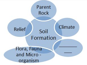
- a)Mulching
- b)Time
- c)Shelter Belts
- d)Contour Lines
Correct answer is option 'B'. Can you explain this answer?
Analyse the given representation and complete the blank by filling it up an important factor of soil formation.
a)
Mulching
b)
Time
c)
Shelter Belts
d)
Contour Lines
 | Tarun Rawat answered |
Time is one of those factors which determines the quality of soil formation.
Large scale destruction of forests cover and arable land has occurred due to the following:- a)Growing population
- b)Ever growing demand of the population
- c)Both (a) and (b)
- d)None of these
Correct answer is option 'C'. Can you explain this answer?
Large scale destruction of forests cover and arable land has occurred due to the following:
a)
Growing population
b)
Ever growing demand of the population
c)
Both (a) and (b)
d)
None of these
| | Aditya Shah answered |
Growing population and their ever-growing demand have led to large-scale forest cover and arable land destruction. Afforestation, land reclamation, regulated use of chemical pesticides and fertilisers, and checks on overgrazing are standard methods to conserve land resources.
An international convention has been established that lists several species of animals and birds in which trade is prohibited.- a)CITES
- b)UN
- c)WTO
- d)None of these
Correct answer is option 'A'. Can you explain this answer?
An international convention has been established that lists several species of animals and birds in which trade is prohibited.
a)
CITES
b)
UN
c)
WTO
d)
None of these
 | Trisha Vashisht answered |
An international convention CITES has been established that lists several species of animals and birds in which trade is prohibited.
How much per cent of the earth’s area is occupied by Ocean?- a)71%
- b)52%
- c)41%
- d)65%
Correct answer is option 'A'. Can you explain this answer?
How much per cent of the earth’s area is occupied by Ocean?
a)
71%
b)
52%
c)
41%
d)
65%
| | EduRev Class 8 answered |
71 percent of the earth's surface is occupied by the seas and oceans.
The quality of land differs from place to place.- a)True
- b)False
Correct answer is option 'A'. Can you explain this answer?
The quality of land differs from place to place.
a)
True
b)
False
| | Aditya Shah answered |
Quality of land differs from place to place. Land quality varies from one place. It depends on factors like the soil, climate, rainfall, and nature of the coast-line determine whether land produces much or little for example, Kerala is situated along the coastal lines.
What major factor influences soil formation?- a)Human activity
- b)Parent rock and climatic factors
- c)Availability of water
- d)Type of vegetation
Correct answer is option 'B'. Can you explain this answer?
a)
Human activity
b)
Parent rock and climatic factors
c)
Availability of water
d)
Type of vegetation
| | EduRev Class 8 answered |
The nature of the parent rock and climatic factors are major determinants of soil formation, influencing its composition and fertility.
What is a major threat to the environment due to the expansion of agriculture and construction activities?- a)Increased urbanization
- b)Land degradation
- c)Improved infrastructure
- d)Enhanced economic growth
Correct answer is option 'B'. Can you explain this answer?
a)
Increased urbanization
b)
Land degradation
c)
Improved infrastructure
d)
Enhanced economic growth
 | C K Academy answered |
The expansion of agriculture and construction activities leads to land degradation, including issues like soil erosion, landslides, and desertification, posing significant threats to the environment.
Which of the following determines the use of land?- a)Soil and topography
- b)Climate and vegetation
- c)Availability of water
- d)All of these
Correct answer is option 'D'. Can you explain this answer?
Which of the following determines the use of land?
a)
Soil and topography
b)
Climate and vegetation
c)
Availability of water
d)
All of these
| | Shubham Sharma answered |
The use of land is determined by physical factors such as topography, soil, climate, minerals, and availability of water. Human factors such as population and technology are also important determinants of land use patterns.
________determines thickness of soil profile.- a)Climate
- b)Time
- c)Relief
- d)Wind
Correct answer is option 'B'. Can you explain this answer?
________determines thickness of soil profile.
a)
Climate
b)
Time
c)
Relief
d)
Wind
| | Vivek Rana answered |
Time determines the thickness of Soil pro le, climate determines the rate of weathering and formation of Humus; relief affects the soil accumulation.
What are common property resources?- a)Land owned by the government
- b)Land used for commercial purposes
- c)Land owned by the community for common uses
- d)Private lands used for agriculture
Correct answer is option 'C'. Can you explain this answer?
a)
Land owned by the government
b)
Land used for commercial purposes
c)
Land owned by the community for common uses
d)
Private lands used for agriculture
| | Rajveer Joshi answered |
Understanding Common Property Resources
Common property resources are essential assets owned collectively by a community, allowing members to utilize them for various purposes without individual ownership. These resources are vital for the sustenance and well-being of communities, especially in rural areas.
Characteristics of Common Property Resources:
- Collective Ownership: These resources are not owned by any single individual but by a community or group. This allows for shared access and management.
- Shared Usage: Members of the community have the right to use these resources. Examples include pasture lands, forests, water bodies, and fishing grounds.
- Sustainable Management: The community often develops norms and rules to manage these resources sustainably, ensuring they are not over-exploited.
Examples of Common Property Resources:
- Pasture Land: Areas where community members graze their livestock.
- Forests: Woodlands that provide timber, fuel, and other forest products for community use.
- Water Bodies: Rivers, lakes, and ponds that are used for fishing, irrigation, and drinking water.
- Fishing Grounds: Coastal or riverine areas where community members fish for their sustenance.
Importance of Common Property Resources:
- Economic Support: They provide essential resources for livelihoods, especially for marginalized communities.
- Social Cohesion: The management of these resources fosters cooperation and strengthens community bonds.
- Environmental Sustainability: Proper management helps in conserving biodiversity and maintaining ecological balance.
In summary, option 'C' is correct because common property resources are lands or resources owned by the community for common uses, distinguishing them from government-owned lands or private properties used for commercial agriculture.
What does the term Land degradation refer to?- a)Decline in the use of fertilizers
- b)The decline in the productivity of cultivated land or forest land
- c)Presence of rocks and minerals in the soil
- d)The slope of the land
Correct answer is option 'B'. Can you explain this answer?
What does the term Land degradation refer to?
a)
Decline in the use of fertilizers
b)
The decline in the productivity of cultivated land or forest land
c)
Presence of rocks and minerals in the soil
d)
The slope of the land
| | Prasenjit Chauhan answered |
Land degradation refers to the decline in the productivity of cultivated land or forest land, leading to a reduction in its ability to support the growth of vegetation. It is a complex process that involves the loss of soil fertility, erosion, deforestation, desertification, and other factors that reduce the quality of land.
Causes of Land Degradation:
• Unsustainable agricultural practices
• Overgrazing
• Deforestation
• Urbanization
• Mining
• Climate change
Effects of Land Degradation:
• Reduced soil fertility
• Soil erosion
• Desertification
• Loss of biodiversity
• Reduced agricultural productivity
• Water scarcity
Prevention and Control Measures:
• Sustainable agricultural practices
• Afforestation and reforestation
• Conservation of soil and water resources
• Integrated land use planning
• Use of organic fertilizers and biopesticides
• Land restoration and rehabilitation
Conclusion:
Land degradation is a serious threat to the environment and human well-being. It is important to take measures to prevent and control it in order to ensure sustainable development. This can be achieved through a combination of policy interventions, community participation, and technological innovations.
What is the significance of the varied characteristics of land and climate?- a)They have no impact on human settlement
- b)They determine the economic activities in a region
- c)They are irrelevant to agriculture
- d)They solely affect wildlife
Correct answer is option 'B'. Can you explain this answer?
a)
They have no impact on human settlement
b)
They determine the economic activities in a region
c)
They are irrelevant to agriculture
d)
They solely affect wildlife
| | Trisha Vashisht answered |
The varied characteristics of land and climate significantly impact human settlement patterns and economic activities, determining the suitability of land for agriculture, habitation, and other uses.
Private land properties are owned by- a)Cooperative societies
- b)Individuals
- c)Communities
- d)Schools
Correct answer is option 'B'. Can you explain this answer?
Private land properties are owned by
a)
Cooperative societies
b)
Individuals
c)
Communities
d)
Schools
| | Aditya Shah answered |
Private properties are lands and buildings owned by individuals and corporations. The owner of private property has the right to use, occupation, sell, or lease his/her property.
Why is it necessary to increase the area under forests?- a)To maintain ecological balance
- b)Forest absorb carbon dioxide from the atmosphere
- c)Forest help in raising the level of precipitation
- d)All of these
Correct answer is option 'D'. Can you explain this answer?
Why is it necessary to increase the area under forests?
a)
To maintain ecological balance
b)
Forest absorb carbon dioxide from the atmosphere
c)
Forest help in raising the level of precipitation
d)
All of these
| | Shubham Sharma answered |
It is essential to raise the area under forest because forests are essential for maintaining the ecological balance. Forest also provides several goods that are required for industry and medicines etc. Forest also helps in soil conservation and rainfall.
Mass movement of rocks down the hills could be a sign of- a)Landslides
- b)Floods
- c)Deforestation
- d)Weathering
Correct answer is option 'A'. Can you explain this answer?
Mass movement of rocks down the hills could be a sign of
a)
Landslides
b)
Floods
c)
Deforestation
d)
Weathering
| | Aditya Shah answered |
Mass movement, also called Mass Wasting, bulk movements of soil and rock debris down slopes in response to the pull of gravity, or the rapid or gradual sinking of the Earth’s ground surface in a predominantly vertical direction. Formerly, the term mass wasting referred to a variety of processes by which large masses of crustal materials are moved by gravity from one place to another. More recently, the term mass movement has been substituted to include mass wasting processes and the sinking of confined areas of the Earth’s ground surface. Mass movements on slopes and sinking mass movements are often aided by water, and the significance of both types is the part each plays in the alteration of landforms.
Complete the blank:With respect to the classification of the land based on soil fertility is called _____.- a)Fertile Land
- b)Rural Land
- c)Private Land
- d)Urban Land
Correct answer is option 'A'. Can you explain this answer?
Complete the blank:
With respect to the classification of the land based on soil fertility is called _____.
a)
Fertile Land
b)
Rural Land
c)
Private Land
d)
Urban Land
| | EduRev Class 8 answered |
The correct answer is A: Fertile Land.
- Classification of land based on soil fertility involves assessing the ability of the soil to support plant growth and agriculture.
- Fertile land has high nutrient availability, good soil structure, and adequate water retention, making it ideal for farming.
- Other options, such as Rural Land, Private Land, and Urban Land, do not specifically relate to soil fertility but rather to location or ownership.
What is the process of land reclamation?- a)Converting desert land into urban areas
- b)Restoring degraded land to a useful state
- c)Expanding agricultural land into forests
- d)Draining wetlands for industrial use
Correct answer is option 'B'. Can you explain this answer?
a)
Converting desert land into urban areas
b)
Restoring degraded land to a useful state
c)
Expanding agricultural land into forests
d)
Draining wetlands for industrial use
| | Manasa Joshi answered |
Understanding Land Reclamation
Land reclamation is a significant environmental and engineering process aimed at restoring degraded land to a useful state. This process can involve various techniques depending on the specific type of land being reclaimed.
What is Land Reclamation?
- Land reclamation refers to the process of improving land that has been damaged or degraded, making it suitable for agricultural, industrial, or recreational use.
- It often focuses on areas that have suffered from erosion, pollution, or other forms of degradation.
Why is Option 'B' Correct?
- Restoring Degraded Land: This option specifically addresses the intent of reclamation, which is to take land that has lost its natural productivity and restore it to a state where it can again serve a beneficial purpose.
- Environmental Impact: Reclamation efforts often include planting vegetation, improving soil quality, and enhancing biodiversity, contributing positively to the ecosystem.
- Practical Applications: Examples include rehabilitating mines, cleaning up contaminated sites, and converting former industrial areas into parks or agricultural land.
Other Options Explained
- Option 'A': Converting desert land into urban areas does not typically fall under reclamation; it involves different developmental strategies.
- Option 'C': Expanding agricultural land into forests conflicts with environmental conservation principles.
- Option 'D': Draining wetlands for industrial use is often detrimental to ecosystems and is not considered reclamation.
In conclusion, option 'B' encapsulates the essence of land reclamation by emphasizing the restoration of degraded land to a functional state, making it the correct answer.
The type of soil is determined by- a)landforms
- b)soil erosion
- c)water sources
- d)Globalisation
Correct answer is option 'A'. Can you explain this answer?
The type of soil is determined by
a)
landforms
b)
soil erosion
c)
water sources
d)
Globalisation
| | Roshni Chauhan answered |
The type of soil is determined by landforms. The geological processes that shape the landforms also play a significant role in determining the characteristics of the soil found in a particular area. Here is a detailed explanation of how landforms influence soil formation:
1. Parent Material:
- The parent material refers to the rock or sediment from which the soil is derived.
- Landforms such as mountains, hills, valleys, and plains have different types of parent material due to various geological processes like weathering, erosion, and deposition.
- For example, mountains often have rocky and coarse parent material, while valleys may have a mix of sedimentary deposits from nearby rivers.
2. Elevation and Slope:
- The elevation and slope of a landform affect the distribution of temperature, precipitation, and drainage patterns.
- Higher elevations tend to have cooler temperatures and receive more precipitation, leading to the formation of different soil types.
- Steep slopes can result in erosion, leading to thinner soils, while flat or gently sloping landforms may accumulate more sediment and develop deeper soils.
3. Drainage:
- The topography of a landform determines how water moves through the soil.
- Areas with good drainage allow excess water to flow away, preventing waterlogging and the accumulation of salts.
- In contrast, poorly drained areas can lead to waterlogging and the development of water-saturated soils.
4. Climate:
- Landforms can influence local climate conditions, including temperature, precipitation, and wind patterns.
- Climate plays a crucial role in soil formation as it affects the rates of weathering, erosion, and organic matter decomposition.
- For example, areas with high rainfall tend to have leached soils with lower nutrient content, while arid regions may have soils with high salt content.
5. Time:
- The age of a landform also influences the development of soil.
- Older landforms have undergone more weathering and erosion processes, resulting in more mature and developed soils.
- Younger landforms, on the other hand, may have relatively new or less developed soils.
In conclusion, landforms have a significant impact on the type of soil found in a particular area. Factors such as parent material, elevation, slope, drainage, climate, and time all contribute to the formation and characteristics of the soil. By understanding the relationship between landforms and soil, scientists can study and classify different soil types based on their geological origins.
What is the 'water cycle' referred to ?- a)The process of water moving from oceans to land and back
- b)The cycle of water turning into ice and then melting
- c)The movement of water only in the oceans
- d)The process of water disappearing from the earth
Correct answer is option 'A'. Can you explain this answer?
What is the 'water cycle' referred to ?
a)
The process of water moving from oceans to land and back
b)
The cycle of water turning into ice and then melting
c)
The movement of water only in the oceans
d)
The process of water disappearing from the earth
| | EduRev Class 8 answered |
The correct answer is A: The process of water moving from oceans to land and back.
- Water cycle, also known as the hydrological cycle, is the continuous movement of water on, above, and below the surface of the Earth.
- It involves the processes of evaporation, condensation, precipitation, and runoff, allowing water to circulate between the atmosphere, land, and oceans.
- Water evaporates from the oceans, forms clouds in the atmosphere, falls back to the Earth as precipitation (rain or snow), and flows back into the oceans through rivers and streams.
- This cycle is crucial for maintaining the Earth's water balance and supporting life on our planet.
What is one method to conserve land resources?- a)Intensive farming
- b)Industrial expansion
- c)Afforestation
- d)Increased urbanization
Correct answer is option 'C'. Can you explain this answer?
a)
Intensive farming
b)
Industrial expansion
c)
Afforestation
d)
Increased urbanization
| | Snehal Joshi answered |
Understanding Afforestation
Afforestation is the process of planting trees in an area where there was no previous tree cover. This practice plays a crucial role in conserving land resources.
Benefits of Afforestation
- Soil Conservation:
Trees help in preventing soil erosion by anchoring the soil with their root systems. This is vital for maintaining soil fertility and preventing land degradation.
- Water Conservation:
Forests play a significant role in water cycles. They help in increasing groundwater levels and maintaining the water table, which is essential for agriculture and drinking water supplies.
- Biodiversity Enhancement:
Afforestation creates habitats for various species, promoting biodiversity. A rich biodiversity is essential for ecological balance and resilience against environmental changes.
- Carbon Sequestration:
Trees absorb carbon dioxide, a major greenhouse gas, thus helping to mitigate climate change. This contributes to a healthier environment and sustainable land use.
Comparison with Other Options
- Intensive Farming:
While it can increase agricultural output, it often leads to soil depletion and increased land degradation.
- Industrial Expansion:
This tends to consume large land areas, leading to habitat destruction and environmental pollution.
- Increased Urbanization:
Urban expansion leads to the reduction of green spaces and natural habitats, negatively impacting land resources.
Conclusion
In summary, afforestation is a sustainable method to conserve land resources. It not only enhances land quality but also supports environmental health and biodiversity, making it a preferable option over methods like industrial expansion or urbanization.
Which of the following method is used in the Western and Central Himalayas for soil conservation?- a)Terrace farming
- b)Strip cropping
- c)Shelterbelts
- d)None of these
Correct answer is option 'A'. Can you explain this answer?
Which of the following method is used in the Western and Central Himalayas for soil conservation?
a)
Terrace farming
b)
Strip cropping
c)
Shelterbelts
d)
None of these
| | Aditya Shah answered |
Steps can be cut out on the slopes making terraces. Terrace cultivation restricts erosion. Western and central Himalayas have well-developed terrace farming.
Which is not an example of groundwater?- a)Water flowing in rivers
- b)Water through wells
- c)Water through hand pumps
- d)Water through submersible pumps
Correct answer is option 'A'. Can you explain this answer?
Which is not an example of groundwater?
a)
Water flowing in rivers
b)
Water through wells
c)
Water through hand pumps
d)
Water through submersible pumps
| | Shubham Sharma answered |
Groundwater is water that exists underground in saturated zones beneath the land surface. The upper body of the saturated zone is called the water table. It fills the pores and fractures in underground materials such as sand, gravel, and other rock, much like water fills a sponge.
Cite the most important reason as to why Land degradation, landslides, soil erosion, desertification etc are major threats to the environment, from the following options.- a)Because of the expansion on agriculture and construction activities
- b)Because people and their demands are growing because the availability of land is not limited.
- c)Because of the superior quality of land used for cultivation
- d)Because of suitable, planned and scientific methods of cultivation
Correct answer is option 'A'. Can you explain this answer?
Cite the most important reason as to why Land degradation, landslides, soil erosion, desertification etc are major threats to the environment, from the following options.
a)
Because of the expansion on agriculture and construction activities
b)
Because people and their demands are growing because the availability of land is not limited.
c)
Because of the superior quality of land used for cultivation
d)
Because of suitable, planned and scientific methods of cultivation
| | Varun Kapoor answered |
The most important reason for land degradation, landslides, soil erosion, and desertification being major threats to the environment is because of the expansion on agriculture and construction activities. These activities often involve the clearing of land and the alteration of natural landscapes, which can lead to soil erosion and degradation. Land degradation is a significant environmental issue because it can reduce the productivity of land and make it less capable of supporting plant and animal life. It can also contribute to other environmental problems such as landslides and desertification. Therefore, it is important to consider the environmental impacts of agriculture and construction activities and to take steps to minimize their negative effects on the land.
Which of the following is a famous bird sanctuary?- a)Kaziranga National Park
- b)Tiger Park at Dudhwa
- c)Gir forest
- d)Bharatpur Sanctuary
Correct answer is option 'D'. Can you explain this answer?
Which of the following is a famous bird sanctuary?
a)
Kaziranga National Park
b)
Tiger Park at Dudhwa
c)
Gir forest
d)
Bharatpur Sanctuary
| | Rohit Sharma answered |
A bird sanctuary is an area of land where birds are protected and encouraged to breed. Or Bird sanctuaries are nature facilities that advocate the conservation of various species of birds and their natural habitats while promoting rehabilitation and survival. Keoladeo National Park is previously called Bharatpur Bird sanctuary. It is a famous bird sanctuary located at Bharatpur. Rajasthan is a famous avifauna (the birds of a particular region, habitat, or geological period)sanctuary that hosts thousands of birds, especially during the winter season. Hence a famous bird sanctuary is the Keoladeo Ghana sanctuary.
The lowermost layer of the soil is:- a)Weathered rock
- b)Parent rock
- c)Subsoil
- d)None of these
Correct answer is option 'B'. Can you explain this answer?
The lowermost layer of the soil is:
a)
Weathered rock
b)
Parent rock
c)
Subsoil
d)
None of these
| | Aditya Shah answered |
Their colour and size of particles can easily observe the layers of soils. The main layers of the earth are topsoil, subsoil, and parent rock. Each layer has its characteristics.
What is a critical challenge in maintaining water resources?- a)Overuse and pollution
- b)Abundant supply
- c)Lack of demand
- d)Limited agricultural use
Correct answer is option 'A'. Can you explain this answer?
a)
Overuse and pollution
b)
Abundant supply
c)
Lack of demand
d)
Limited agricultural use
| | EduRev Class 8 answered |
A critical challenge in maintaining water resources is their overuse and pollution, which make water unfit for use and reduce the availability of clean water for essential activities.
Which regions are most susceptible to droughts and water scarcity?- a)Coastal regions
- b)Tropical rainforests
- c)Climates with seasonal or annual precipitation variations
- d)Urban centers with abundant water supply
Correct answer is option 'C'. Can you explain this answer?
a)
Coastal regions
b)
Tropical rainforests
c)
Climates with seasonal or annual precipitation variations
d)
Urban centers with abundant water supply
| | Anshu Dasgupta answered |
Understanding Drought Susceptibility
Drought and water scarcity significantly impact various regions across the globe. Among the options provided, climates with seasonal or annual precipitation variations are the most susceptible.
Why Option C is Correct:
- Variability in Precipitation:
Regions with seasonal or annual variations often experience unpredictable rainfall patterns. This inconsistency makes it challenging for agriculture and water supply management.
- Impact on Agriculture:
These areas rely heavily on rain-fed agriculture. Insufficient rainfall can lead to crop failures, affecting food security and local economies.
- Water Resource Management:
In regions with fluctuating precipitation, water resources are often overexploited during wetter seasons, leading to depletion during dry spells.
- Increased Drought Frequency:
Climate change exacerbates these variations, increasing the frequency and intensity of droughts, which can lead to long-term water scarcity.
Other Options Explained:
- Coastal Regions:
Typically benefit from proximity to oceans, allowing for greater evaporation and rainfall, reducing drought risk.
- Tropical Rainforests:
These regions experience consistent, high rainfall throughout the year, making them less susceptible to drought.
- Urban Centers with Abundant Water Supply:
Cities often have infrastructure to manage and distribute water efficiently, even during dry spells.
Conclusion:
Thus, regions with significant seasonal or annual precipitation variations face the highest risk of drought and water scarcity due to their inherent climatic instability and reliance on consistent rainfall.
What determines the use of land for agriculture, forestry, mining, and other purposes?- a)Government policies
- b)Economic factors alone
- c)Physical and human factors
- d)Historical significance
Correct answer is option 'C'. Can you explain this answer?
a)
Government policies
b)
Economic factors alone
c)
Physical and human factors
d)
Historical significance
| | Trisha Vashisht answered |
The use of land is determined by a combination of physical factors (such as topography, soil, climate, minerals, and water availability) and human factors (such as population and technology).
______is the use of land for different purposes like agriculture, forestry, mining, construction of buildings, houses, industries, and road.- a)Land degradation
- b)Land use
- c)Landfilling
- d)Land digging
Correct answer is option 'B'. Can you explain this answer?
______is the use of land for different purposes like agriculture, forestry, mining, construction of buildings, houses, industries, and road.
a)
Land degradation
b)
Land use
c)
Landfilling
d)
Land digging
| | Aditya Shah answered |
Plains and river valleys offer suitable land for agriculture. Hence, these are the densely populated areas of the world. The land is used for different purposes such as agriculture, forestry, mining, building houses, roads, and industries. This is commonly termed Land use.
Natural resources are essential for the economic development of a country.- a)True
- b)False
Correct answer is option 'A'. Can you explain this answer?
Natural resources are essential for the economic development of a country.
a)
True
b)
False
| | Vivek Rana answered |
Natural resources, both renewable and non-renewable, and ecosystem services are a part of the real wealth of nations. They are the natural capital out of which other forms of money are made. They contribute towards fiscal revenue, income, and poverty reduction.
Soil is made up of- a)water
- b)metals
- c)organic materials & rocks
- d)ice
Correct answer is option 'C'. Can you explain this answer?
Soil is made up of
a)
water
b)
metals
c)
organic materials & rocks
d)
ice
| | Amrita Nair answered |
Understanding Soil Composition
Soil is a complex mixture that plays a crucial role in the ecosystem. The correct answer to the question about what soil is made of is option 'C': organic materials and rocks. Here’s a detailed breakdown:
Components of Soil
- Organic Materials:
Soil contains decayed plant and animal matter, commonly referred to as humus. This organic matter enriches the soil by providing essential nutrients that support plant growth. It also enhances soil structure and improves its ability to retain moisture.
- Mineral Particles (Rocks):
Soil is primarily composed of mineral particles that originate from the weathering of rocks. These minerals include sand, silt, and clay, each contributing different properties to the soil. For example, sandy soil drains quickly while clay retains water more effectively.
Other Components
- Water:
While water is present in soil as moisture, it is not a primary component of soil itself. Water plays a vital role in soil health by dissolving nutrients and facilitating plant uptake.
- Air:
Soil also contains air pockets that provide essential oxygen for root respiration and microbial activity. However, similar to water, air is not a main constituent.
- Ice:
Ice can form in soil during cold temperatures, but it is not considered a primary component of soil.
Conclusion
In summary, soil is fundamentally composed of organic materials and rock particles, making option 'C' the correct choice. Understanding these components is essential for appreciating the vital role that soil plays in supporting life on Earth.
What does the zig-zag line indicate on the map of India?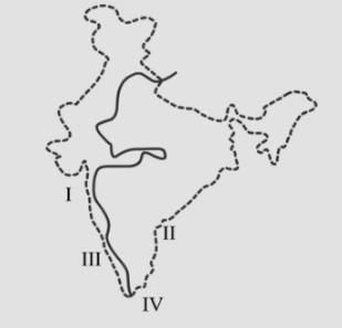
- a)Advancement summer monsoon on June
- b)Line dividing tropical evergreen and deciduous forest
- c)Water divide between east and west flowing rivers
- d)Line dividing annual rainfall above and below cm
Correct answer is option 'C'. Can you explain this answer?
What does the zig-zag line indicate on the map of India?
a)
Advancement summer monsoon on June
b)
Line dividing tropical evergreen and deciduous forest
c)
Water divide between east and west flowing rivers
d)
Line dividing annual rainfall above and below cm
| | Rohit Sharma answered |
In the given map the line represents a ‘water divide’ between east-flowing rivers like Mahanadi, Godavari, Krishna, Cauvery, etc., and west-flowing rivers like Narmada and Tapti.
From the attached image, identify the profile of Soil marked B 
- a)Top soil
- b)Sub soil
- c)Parent Rock
- d)Weathered Rock Material
Correct answer is option 'B'. Can you explain this answer?
From the attached image, identify the profile of Soil marked B
a)
Top soil
b)
Sub soil
c)
Parent Rock
d)
Weathered Rock Material
| | Arka Sarkar answered |
The soil is arranged in layers or horizons during its formation. These layers or horizons are known as the soil profile. It is the vertical section of the soil that is exposed by a soil pit. The layers of soil can easily be identified by the soil colour and size of soil particles. The different layers of soil are:
- Topsoil
- Subsoil
- Parent rock
The Land Use in a few selected countries according to their percentage area is given below. Analyse the table and answer the questions. Name the country that uses the maximum land for cultivation 
- a)India
- b)UK
- c)France
- d)Australia
Correct answer is option 'A'. Can you explain this answer?
The Land Use in a few selected countries according to their percentage area is given below. Analyse the table and answer the questions. Name the country that uses the maximum land for cultivation
a)
India
b)
UK
c)
France
d)
Australia
| | Madhu Sulaniya answered |
Cropland is the land used for growing crops. therefore from the above table India has the highest value of cropland hence it uses the max land for cultivation.
From the attached image of the profile of Soil, identify the one that has a fine texture, a high content of organic matter in humus and is vital for plant growth
- a)Sub Soil
- b)Weathered Rock Material
- c)Parent Rock
- d)Top soil
Correct answer is option 'D'. Can you explain this answer?
From the attached image of the profile of Soil, identify the one that has a fine texture, a high content of organic matter in humus and is vital for plant growth
a)
Sub Soil
b)
Weathered Rock Material
c)
Parent Rock
d)
Top soil
| | Krish Dasgupta answered |
Topsoil is the upper, outermost layer of soil, usually the top 5–10 inches (13–25 cm). It has the highest concentration of organic matter and microorganisms and is where most of the Earth's biological soil activity occurs. Topsoil is composed of mineral particles, organic matter, water, and air. Organic matter varies in quantity on different soils.
Chapter doubts & questions for Land, Soil, Water, Natural Vegetation and Wildlife Resources - Social Studies (SST) Class 8 2026 is part of Class 8 exam preparation. The chapters have been prepared according to the Class 8 exam syllabus. The Chapter doubts & questions, notes, tests & MCQs are made for Class 8 2026 Exam. Find important definitions, questions, notes, meanings, examples, exercises, MCQs and online tests here.
Chapter doubts & questions of Land, Soil, Water, Natural Vegetation and Wildlife Resources - Social Studies (SST) Class 8 in English & Hindi are available as part of Class 8 exam. Download more important topics, notes, lectures and mock test series for Class 8 Exam by signing up for free.
Social Studies (SST) Class 886 videos|559 docs|53 tests |