


All Exams > Class 8 > GK Olympiad for Class 8 > All Questions
All questions of Indian Geography for Class 8 Exam
Which nation, shares the maximum number of borders, 14 in number, with neighbouring countries?- a)Ukraine
- b)China
- c)Turkey
- d)Mongolia
Correct answer is option 'B'. Can you explain this answer?
Which nation, shares the maximum number of borders, 14 in number, with neighbouring countries?
a)
Ukraine
b)
China
c)
Turkey
d)
Mongolia
| | Prerna Nambiar answered |
China shares the maximum number of borders, 14 in number, with neighboring countries. Here is an explanation of why China holds this distinction:
Geographical Location:
China is located in East Asia and has a vast territory, covering approximately 9.6 million square kilometers. Its geographical location places it in close proximity to several countries, making it share borders with a large number of neighboring nations.
Bordering Countries:
China shares its borders with the following 14 countries:
1. Afghanistan
2. Bhutan
3. India
4. Kazakhstan
5. Kyrgyzstan
6. Laos
7. Mongolia
8. Myanmar (Burma)
9. Nepal
10. North Korea
11. Pakistan
12. Russia
13. Tajikistan
14. Vietnam
Reasons for Multiple Borders:
There are several reasons why China shares borders with so many countries:
1. Historical Factors: Historical events, such as the expansion of Chinese territories and the formation of borders during different dynasties, have contributed to China's complex border network.
2. Geographical Features: China's diverse geographical features, including mountain ranges, rivers, and plateaus, have played a significant role in shaping its borders. For example, the Himalayas act as a natural barrier between China and neighboring countries like India, Nepal, and Bhutan.
3. Strategic Importance: China's borders hold strategic importance in terms of trade, security, and geopolitical influence. These factors have led to the establishment of borders with multiple countries to facilitate economic activities and safeguard national interests.
4. Political Considerations: China's political relations with neighboring countries have also influenced its border arrangements. Diplomatic negotiations, historical disputes, and territorial claims have shaped the current border lines.
Conclusion:
In summary, China shares the maximum number of borders, 14 in number, with neighboring countries due to a combination of historical, geographical, strategic, and political factors. Its vast territory and complex border network make China a unique country with extensive connections to its neighbors.

The Equator does NOT pass through which of the following countries?- a)Kenya
- b)Mexico
- c)Indonesia
- d)Brazil
Correct answer is option 'B'. Can you explain this answer?
The Equator does NOT pass through which of the following countries?
a)
Kenya
b)
Mexico
c)
Indonesia
d)
Brazil
| | Anushka Nambiar answered |
Explanation:
The Equator is an imaginary line that divides the Earth into the Northern Hemisphere and the Southern Hemisphere. It is the line of latitude 0°, and it passes through several countries around the world. However, it does not pass through Mexico, making option B the correct answer.
Reasoning:
- Kenya: The Equator passes through Kenya, specifically near the town of Nanyuki. Kenya is located in East Africa and is known for its diverse wildlife, national parks, and beautiful landscapes.
- Mexico: The Equator does not pass through Mexico. Mexico is located in North America, and its latitude is above the equatorial line.
- Indonesia: The Equator passes through Indonesia, specifically through the islands of Sumatra, Kalimantan (Borneo), and Sulawesi. Indonesia is an archipelago country located in Southeast Asia.
- Brazil: The Equator passes through Brazil, specifically through the northern states of Amapá, Amazonas, Pará, and Roraima. Brazil is the largest country in South America and is known for its Amazon rainforest and the Amazon River.
Conclusion:
In conclusion, out of the given options, the Equator does not pass through Mexico (option B). It passes through Kenya, Indonesia, and Brazil.
The winter rain in Madras is caused by- a)South-West Monsoons
- b)North-East Monsoons
- c)Intense land and sea breezes
- d)Cyclonic winds in the Bay of Bengal
Correct answer is option 'B'. Can you explain this answer?
The winter rain in Madras is caused by
a)
South-West Monsoons
b)
North-East Monsoons
c)
Intense land and sea breezes
d)
Cyclonic winds in the Bay of Bengal
| | Anirudh Pillai answered |
The answer is option 'B': North-East Monsoons.
The winter rain in Madras (now known as Chennai) is primarily caused by the North-East Monsoons. Let's understand this in detail:
What are Monsoons?
Monsoons are seasonal winds that bring heavy rainfall to certain regions. In India, there are two main monsoons - the South-West Monsoons and the North-East Monsoons.
South-West Monsoons:
South-West Monsoons occur during the summer months and bring rainfall to the western coast of India, including regions like Mumbai, Goa, and Kerala. These monsoons are responsible for the majority of the rainfall in India.
North-East Monsoons:
North-East Monsoons occur during the winter months, typically from October to December. These monsoons bring rainfall to the eastern coast of India, including regions like Chennai, Puducherry, and parts of Andhra Pradesh.
Why are North-East Monsoons responsible for winter rain in Madras?
1. Wind Direction: During the North-East Monsoons, the prevailing winds blow from the north-east direction towards the land. These winds pick up moisture from the Bay of Bengal and carry it towards the eastern coast of India.
2. Interaction with Eastern Ghats: The Eastern Ghats mountain range runs parallel to the eastern coast of India. When the moist winds from the Bay of Bengal encounter these mountains, they are forced to rise. As the air rises, it cools down, leading to the condensation of moisture and the formation of rain clouds.
3. Intensification over Chennai: As the moist winds continue to move towards Chennai, they encounter the low-lying coastal plains. This interaction further enhances the condensation process, resulting in heavy rainfall over the region.
4. Duration and Intensity: The North-East Monsoons in Chennai usually last for a few months, during which the region receives a significant amount of rainfall. The intensity of the rainfall can be high, leading to occasional heavy showers.
Overall, the North-East Monsoons are responsible for the winter rain in Madras (Chennai) due to the interaction between the prevailing winds, the Eastern Ghats, and the coastal plains.
The 2017 UNESCO Natural Heritage Festival was held from February 11 to 12, 2017. It was in collaboration with Wildlife Institute of India (WII). In which state was the 2017 UNESCO Natural Heritage festival held?- a)New Delhi
- b)Madhya Pradesh
- c)Uttar Pradesh
- d)Himachal Pradesh
Correct answer is option 'D'. Can you explain this answer?
The 2017 UNESCO Natural Heritage Festival was held from February 11 to 12, 2017. It was in collaboration with Wildlife Institute of India (WII). In which state was the 2017 UNESCO Natural Heritage festival held?
a)
New Delhi
b)
Madhya Pradesh
c)
Uttar Pradesh
d)
Himachal Pradesh
| | Vivek Bansal answered |
The 2017 UNESCO Natural Heritage Festival was held at Great Himalayan National Park (GHNP) in Sairopa, Himachal Pradesh from February 11th to 12th.
The fest was held in collaboration with the Wildlife Institute of India (WII) and was attended by many prominent conservationists.
The festival featured a media workshop on environmental journalism, discussions on natural and cultural heritage of the Himalayan region and a heritage walk.
The fest was held in collaboration with the Wildlife Institute of India (WII) and was attended by many prominent conservationists.
The festival featured a media workshop on environmental journalism, discussions on natural and cultural heritage of the Himalayan region and a heritage walk.
The northernmost point of India is known as:- a)Indira Heights
- b)Indira Col
- c)Indira Point
- d)None of the above
Correct answer is option 'B'. Can you explain this answer?
The northernmost point of India is known as:
a)
Indira Heights
b)
Indira Col
c)
Indira Point
d)
None of the above
| | Priyanka Kapoor answered |
The northernmost point of India lies in the state of Jammu and Kashmir and it is known as Indira Col. The Indira Col (altitude 5,764 metres) is a mountain pass located on the Indira Ridge in the Siachen Muztagh in the Karakoram Range.
The Indus originates in Tibet at the confluence of Sengge and Gar rivers and flows through India and then through Pakistan to ___________.- a)Indian Ocean
- b)Arabian Sea
- c)Bay of Bengal
- d)Palk Strait
Correct answer is option 'B'. Can you explain this answer?
The Indus originates in Tibet at the confluence of Sengge and Gar rivers and flows through India and then through Pakistan to ___________.
a)
Indian Ocean
b)
Arabian Sea
c)
Bay of Bengal
d)
Palk Strait
| | Asha Joshi answered |
The Indus River and its Course
The Indus River is one of the longest rivers in Asia, originating in Tibet and flowing through India and Pakistan. Its course covers a distance of approximately 3,180 kilometers. Let's explore the journey of the Indus River from its origin to its endpoint.
1. Origin in Tibet
The Indus River originates in Tibet at the confluence of the Sengge and Gar rivers. These two rivers join together near Lake Mansarovar, which is situated at an altitude of about 4,500 meters. This marks the beginning of the Indus River's journey.
2. Flow through India
After originating in Tibet, the Indus River flows through the Indian-administered regions of Ladakh and Jammu and Kashmir. It passes through picturesque valleys and gorges, providing water to the surrounding areas and supporting agriculture.
3. Entry into Pakistan
The Indus River enters Pakistan near the town of Skardu, continuing its journey through the Gilgit-Baltistan region. It then passes through the Khyber Pakhtunkhwa province, where it is joined by several tributaries, including the Kabul River.
4. Course through Pakistan
As the Indus River flows southward through Pakistan, it forms the western boundary of Punjab province and the eastern border of Sindh province. It is fed by various tributaries, including the Chenab, Jhelum, and Ravi rivers. These tributaries significantly contribute to the water volume of the Indus River, making it a vital water source for agriculture and hydropower generation in Pakistan.
5. Endpoint - Arabian Sea
Finally, after traversing the length of Pakistan, the Indus River reaches its endpoint at the Arabian Sea. It forms a large delta known as the Indus River Delta, which is home to mangrove forests, marshes, and diverse wildlife. The river deposits a significant amount of sediment in the delta, enriching the soil and supporting agriculture in the region.
Conclusion
The Indus River originates in Tibet, flows through India and Pakistan, and finally empties into the Arabian Sea. Its course is essential for the livelihoods of millions of people, providing water for irrigation, drinking, and various economic activities along its banks. The river's journey showcases the interconnectedness of different regions and the significance of water resources in sustaining life and ecosystems.
With the overall clamp down on diesel vehicles in the country due to rising pollution levels, automakers have taken the green step forward, with many introducing hybrid vehicles in India. They are cleaner and more fuel efficient. The Toyota Camry Hybrid is a good example of one such model. It is powered by _______.- a)Petrol and ethanol
- b)Petrol and electricity
- c)Electricity and LPG
- d)Biofuel
Correct answer is option 'B'. Can you explain this answer?
With the overall clamp down on diesel vehicles in the country due to rising pollution levels, automakers have taken the green step forward, with many introducing hybrid vehicles in India. They are cleaner and more fuel efficient. The Toyota Camry Hybrid is a good example of one such model. It is powered by _______.
a)
Petrol and ethanol
b)
Petrol and electricity
c)
Electricity and LPG
d)
Biofuel
| | Anjana Kumar answered |
Answer:
Introduction:
Due to rising pollution levels, there has been a clamp down on diesel vehicles in India. As a result, automakers have started introducing hybrid vehicles in the country. These vehicles are cleaner and more fuel efficient compared to traditional petrol or diesel vehicles. One such model is the Toyota Camry Hybrid.
Explanation:
The Toyota Camry Hybrid is powered by a combination of petrol and electricity, making it a hybrid vehicle. This means that it has both an internal combustion engine (powered by petrol) and an electric motor (powered by electricity). Let's understand how this hybrid system works.
Working of the Toyota Camry Hybrid:
1. Petrol Engine: The Camry Hybrid is equipped with a conventional petrol engine, which is similar to the engines found in regular petrol-powered cars. This engine provides power to the vehicle when driving at higher speeds or when more power is required.
2. Electric Motor: The Camry Hybrid also has an electric motor, which is powered by a high-voltage battery pack. This motor assists the petrol engine during acceleration and at lower speeds, reducing the load on the petrol engine and improving fuel efficiency. The electric motor also works in conjunction with the petrol engine during heavy acceleration, providing additional power.
3. Regenerative Braking: The Camry Hybrid utilizes regenerative braking technology, which converts the kinetic energy generated during braking into electrical energy. This energy is then stored in the battery pack and can be used to power the electric motor, reducing the reliance on the petrol engine and further improving fuel efficiency.
4. Energy Management System: The Camry Hybrid is equipped with an advanced energy management system that intelligently controls the power distribution between the petrol engine and the electric motor. This system ensures optimal performance and efficiency based on driving conditions, such as speed, acceleration, and battery charge level.
Advantages of the Toyota Camry Hybrid:
- Fuel Efficiency: The hybrid system in the Camry Hybrid improves fuel efficiency compared to a traditional petrol-powered vehicle. This helps in reducing fuel consumption and lowering emissions, contributing to a cleaner environment.
- Reduced Pollution: The combination of a petrol engine and an electric motor reduces the overall emissions of the vehicle, making it more environmentally friendly.
- Lower Running Costs: The Camry Hybrid's hybrid system allows it to consume less fuel, resulting in lower running costs for the owner.
- Smooth and Quiet Operation: The electric motor in the Camry Hybrid provides instant torque, resulting in a smooth and quiet driving experience.
Conclusion:
The Toyota Camry Hybrid is a good example of a hybrid vehicle introduced in India to combat rising pollution levels. It is powered by a combination of petrol and electricity, making it cleaner and more fuel efficient compared to traditional petrol or diesel vehicles. The hybrid system in the Camry Hybrid provides various advantages, including improved fuel efficiency, reduced pollution, lower running costs, and a smooth driving experience.
Botanical garden of India which contains collections of world's tropical plants is?- a)National Botanical Garden
- b)The Indian Botanical Garden
- c)Lloyd Botanical Garden
- d)Lalbag Garden
Correct answer is option 'D'. Can you explain this answer?
Botanical garden of India which contains collections of world's tropical plants is?
a)
National Botanical Garden
b)
The Indian Botanical Garden
c)
Lloyd Botanical Garden
d)
Lalbag Garden
| | Gauri Joshi answered |
National Botanical Garden:
- The National Botanical Garden is not the correct answer because it is not specifically known for its collection of tropical plants.
The Indian Botanical Garden:
- The Indian Botanical Garden, also known as the Acharya Jagadish Chandra Bose Indian Botanic Garden, is a botanical garden located in Shibpur, Howrah, near Kolkata, West Bengal, India.
- It is one of the oldest and largest botanical gardens in India, covering an area of about 273 acres.
- The garden was established in 1787 by Colonel Robert Kyd, a British army officer, with the aim of growing and studying various plants for scientific research and educational purposes.
- The Indian Botanical Garden is known for its extensive collection of plants, including rare and endangered species from different parts of India and other tropical regions of the world.
- It serves as a center for conservation, research, and education on plant diversity and ecology.
- The garden is divided into various sections, such as the Palm House, the Orchid House, the Cactus House, and the Economic Plant Section, each showcasing different types of plants and their unique characteristics.
- It also houses a herbarium, containing a large collection of plant specimens preserved for botanical studies and reference purposes.
- The Indian Botanical Garden attracts numerous visitors, including botanists, researchers, students, and nature enthusiasts, who come to explore its diverse plant collections and learn about the importance of plant conservation and biodiversity.
Lloyd Botanical Garden:
- The Lloyd Botanical Garden, located in Darjeeling, West Bengal, is another famous botanical garden in India.
- Although it is known for its beautiful collection of plants, it is not the correct answer to the given question.
Lalbag Garden:
- Lalbag Garden, also known as Lalbagh Botanical Garden, is a popular botanical garden located in Bangalore, Karnataka, India.
- While it is a renowned botanical garden, it is primarily known for its collection of plants native to India and not specifically for tropical plants from around the world.
- Therefore, it is not the correct answer to the question.
In conclusion, the correct answer is option 'b) The Indian Botanical Garden' as it is one of the oldest and largest botanical gardens in India, known for its extensive collection of tropical plants from around the world.
This ship was the largest and most advanced ship of her time with every luxury aboard. On a fateful night in 1912, she hit an iceberg. She sank rapidly in the North Atlantic ocean killing more than 1,500 of the 2,224 passengers. Name the ship.- a)HMS Bounty
- b)RMS Titanic
- c)RMS Carpathia
- d)RMS Olympic
Correct answer is option 'B'. Can you explain this answer?
This ship was the largest and most advanced ship of her time with every luxury aboard. On a fateful night in 1912, she hit an iceberg. She sank rapidly in the North Atlantic ocean killing more than 1,500 of the 2,224 passengers. Name the ship.
a)
HMS Bounty
b)
RMS Titanic
c)
RMS Carpathia
d)
RMS Olympic
| | Abhishek Nair answered |
The Titanic
The correct answer is option 'B', the RMS Titanic.
Introduction
The RMS Titanic was the largest and most advanced ship of her time. It was a luxury passenger liner, known for its opulence and grandeur. However, its maiden voyage in 1912 turned into a tragic disaster when it struck an iceberg and sank rapidly in the North Atlantic Ocean.
Background
The Titanic was built by the British shipping company White Star Line and was designed to be the most luxurious and technologically advanced ship of its era. It was constructed in Belfast, Northern Ireland, and took three years to build. The ship was equipped with state-of-the-art amenities and featured extravagant interiors, including first-class cabins, a swimming pool, a gymnasium, and even a squash court.
The Tragedy
On the night of April 14, 1912, while en route from Southampton, England, to New York City, the Titanic struck an iceberg in the North Atlantic Ocean. The collision caused extensive damage to the ship's hull, leading to flooding in several compartments. Despite efforts to save the ship, it became clear that the Titanic was doomed.
The Sinking
As the Titanic began to sink, the crew worked frantically to launch lifeboats and evacuate the passengers. However, due to a shortage of lifeboats and inadequate emergency procedures, many people were unable to escape. The ship's design, which prioritized luxury over safety, also contributed to the high death toll.
Loss of Life
Out of the 2,224 people on board, more than 1,500 lost their lives in the tragedy. The majority of the casualties were from the lower classes, as many of the lifeboats were reserved for the wealthier passengers. The sinking of the Titanic remains one of the deadliest peacetime maritime disasters in history.
Aftermath and Legacy
The sinking of the Titanic led to significant changes in maritime safety regulations. The disaster highlighted the need for better lifeboat capacity, improved communication systems, and stricter safety measures. As a result, international conventions were established to ensure the safety of future ocean liners.
In conclusion
The RMS Titanic, the largest and most advanced ship of its time, met a tragic fate when it struck an iceberg and sank on its maiden voyage in 1912. The loss of life and the subsequent changes in maritime safety regulations have made the Titanic one of the most infamous and iconic shipwrecks in history.
Find out the correct sequence of the Himalayan peaks in descending order of height above sea level.- a)Kanchenjunga, Dhaulagiri, Annapurna, Nanda Devi
- b)Kanchenjunga, Annapurna, Nanda Devi, Dhaulagiri
- c)Kanchenjunga, Nandi Devi, Dhaulagiri, Annapurna
- d)Dhaulagiri, Kanchenjunga, Nanda Devi, Annapurna
Correct answer is option 'A'. Can you explain this answer?
Find out the correct sequence of the Himalayan peaks in descending order of height above sea level.
a)
Kanchenjunga, Dhaulagiri, Annapurna, Nanda Devi
b)
Kanchenjunga, Annapurna, Nanda Devi, Dhaulagiri
c)
Kanchenjunga, Nandi Devi, Dhaulagiri, Annapurna
d)
Dhaulagiri, Kanchenjunga, Nanda Devi, Annapurna
| | Debolina Saha answered |
The correct sequence of the Himalayan peaks in descending order of height above sea level is:
a) Kanchenjunga, Dhaulagiri, Annapurna, Nanda Devi
Explanation:
- The Himalayan mountain range is home to some of the highest peaks in the world. These peaks are famous for their breathtaking beauty and challenging climbing routes.
- The correct sequence of the Himalayan peaks in descending order of height above sea level is determined by their respective elevations.
1. Kanchenjunga:
- Kanchenjunga is the highest peak in India and the third-highest peak in the world.
- It stands at an elevation of 8,586 meters (28,169 feet) above sea level.
- Located on the border between Nepal and India, Kanchenjunga is a popular destination for mountaineers and trekkers.
2. Dhaulagiri:
- Dhaulagiri is the seventh-highest peak in the world.
- It stands at an elevation of 8,167 meters (26,795 feet) above sea level.
- Located in Nepal, Dhaulagiri is known for its challenging climbing routes and stunning views.
3. Annapurna:
- Annapurna is a massif in the Himalayas, consisting of several peaks.
- The highest peak in the Annapurna range is Annapurna I, which has an elevation of 8,091 meters (26,545 feet) above sea level.
- Annapurna I is the tenth-highest peak in the world and is renowned for its difficult climbing conditions.
4. Nanda Devi:
- Nanda Devi is the second-highest peak in India and the twenty-third highest peak in the world.
- It stands at an elevation of 7,816 meters (25,643 feet) above sea level.
- Nanda Devi is located in the Garhwal Himalayas of Uttarakhand, India, and is known for its stunning beauty and challenging climbing routes.
In conclusion, the correct sequence of the Himalayan peaks in descending order of height above sea level is Kanchenjunga, Dhaulagiri, Annapurna, Nanda Devi.
Identify Incorrect statement. - a)River Nile is south flowing river.
- b)River Chambal flows northward in India.
- c)River Mandovi flows eastward.
- d)Periyar river is the largest river of Kerala.
Correct answer is option 'C'. Can you explain this answer?
Identify Incorrect statement.
a)
River Nile is south flowing river.
b)
River Chambal flows northward in India.
c)
River Mandovi flows eastward.
d)
Periyar river is the largest river of Kerala.
| | Priyanka Kapoor answered |
Mandovi River described as the lifeline of the Indian state of Goa. It flows westward (not eastward) and discharges in Arabian sea.
The largest Muslim country in terms of area ___________.- a)Pakistan
- b)Turkmenistan
- c)Kazakhstan
- d)Afghanistan
Correct answer is option 'C'. Can you explain this answer?
The largest Muslim country in terms of area ___________.
a)
Pakistan
b)
Turkmenistan
c)
Kazakhstan
d)
Afghanistan
| | Vivek Bansal answered |
Largest muslim country is Kazakhstan. Its the 9th biggest country in the world. Algeria is the second largest muslim country. Kazakhstan isn't mentioned a lot because they arent known for any greatness just yet as they became independent 3 about 30 years ago.
Which online portal has been launched in April, 2017 by the Survey of India (SOI) that offers free download of Indian Maps?- a)Map Portal
- b)SOL Portal
- c)Digital Map Portal
- d)Nakshe Portal
Correct answer is option 'D'. Can you explain this answer?
Which online portal has been launched in April, 2017 by the Survey of India (SOI) that offers free download of Indian Maps?
a)
Map Portal
b)
SOL Portal
c)
Digital Map Portal
d)
Nakshe Portal
| | Priyanka Kapoor answered |
The Survey of India launched Nakshe Portal on April 2017, a new web portal to make open series maps available to Indians for free. The portal was launched by Mr. Harsh Vardhan, the Union Minister for Science & Technology and Earth Sciences. The maps are meant to promote developmental activities in the country and also various other projects in India.
Match List I with List II and select the correct answer by using the code given.
- a)A-3, B-5, C-1, D-4
- b)A-3, B-1, C-2, D-5
- c)A-2, B-1, C-3, D-4
- d)A-1, B-4, C-2, D-5
Correct answer is option 'B'. Can you explain this answer?
Match List I with List II and select the correct answer by using the code given.
a)
A-3, B-5, C-1, D-4
b)
A-3, B-1, C-2, D-5
c)
A-2, B-1, C-3, D-4
d)
A-1, B-4, C-2, D-5
| | Priyanka Kapoor answered |
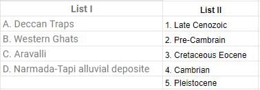
The Deccan Traps were formed during late cretaceous Eocene period.
The Western Ghats were formed during late Cenozoic age.
The Aravallies were formed in Pre-Cambrian period.
The Narmada-Tapti Alluvial deposits were formed during the Pleistocene age.
The Western Ghats were formed during late Cenozoic age.
The Aravallies were formed in Pre-Cambrian period.
The Narmada-Tapti Alluvial deposits were formed during the Pleistocene age.
Which is the oldest landmass of India?- a)The Himalayan Mountain Ranges
- b)The Indus- Ganga Plain
- c)The Peninsular Plateau
- d)The Coastal Pains
Correct answer is option 'C'. Can you explain this answer?
Which is the oldest landmass of India?
a)
The Himalayan Mountain Ranges
b)
The Indus- Ganga Plain
c)
The Peninsular Plateau
d)
The Coastal Pains
| | Vivek Bansal answered |
Geologists believe that the peninsular plateau of India is one of the oldest landmass of not only of India but the entire world. This tableland has behaved as a rigid and inflexible block throughout its geological history and is often compared to a 'horst'.
Which of the following states is odd one out in terms of international border?- a)Rajasthan
- b)Gujarat
- c)Punjab
- d)Haryana
Correct answer is option 'D'. Can you explain this answer?
Which of the following states is odd one out in terms of international border?
a)
Rajasthan
b)
Gujarat
c)
Punjab
d)
Haryana
| | Vivek Bansal answered |
Himachal pradesh, because Rajasthan, Gujarat, Punjab all share their borders with Pakistan and HP do not.
The Indian subcontinent was originally part of a huge land mass called?- a)Jurassic land mass
- b)Aryavarta
- c)Indiane
- d)Gondwana continent
Correct answer is option 'D'. Can you explain this answer?
The Indian subcontinent was originally part of a huge land mass called?
a)
Jurassic land mass
b)
Aryavarta
c)
Indiane
d)
Gondwana continent
| | Vivek Bansal answered |
According to continental drift theory and plate tectonic theory, the Indian subcontinent was a part of a huge land mass known as Gondwana continent. This huge continental mass got split into India, South America, Africa, Australia and Antarctic during the cretaceous period. The Indian Plate moves northward and merged with the Eurasian Plate.
Which of the following bodies has grouped India into four zones as per their propensities of seismicity? - a)Department of Statistics and Programme Implementation
- b)Central Statistical Organisation
- c)Bureau of Indian Standards
- d)Survey of India
Correct answer is option 'C'. Can you explain this answer?
Which of the following bodies has grouped India into four zones as per their propensities of seismicity?
a)
Department of Statistics and Programme Implementation
b)
Central Statistical Organisation
c)
Bureau of Indian Standards
d)
Survey of India
| | Priyanka Kapoor answered |
They are Zone-II, Zone-Ill. Zone-IV and Zone-V. The classification was done in 20022002 when Zone-I was merged into Zone-II.
Consider the following statements:- The Himalayan ranges were formed when the Indian Plate was driven northwards and pushed beneath the Eurasian Plate.
- The Himalayas have reached their old age in the geological history of the earth.
Which of the following statements is/are correct?- a)1 only
- b)2 only
- c)Both 1 and 2
- d)Neither 1 nor 2
Correct answer is option 'A'. Can you explain this answer?
Consider the following statements:
- The Himalayan ranges were formed when the Indian Plate was driven northwards and pushed beneath the Eurasian Plate.
- The Himalayas have reached their old age in the geological history of the earth.
Which of the following statements is/are correct?
a)
1 only
b)
2 only
c)
Both 1 and 2
d)
Neither 1 nor 2
| | Priyanka Kapoor answered |
The Himalayan mountain ranges are still in their youthful stage which is evident from the presence of landforms like gorges, steep sided V-shaped valleys, rapids, falls etc.
Cities generally come up on river banks because of their proximity to water. Water is essential for survival and transport. On which river is Panaji, a city of Goa situated?- a)Mahanadi
- b)Godavari
- c)Kaveri
- d)Mandovi
Correct answer is option 'D'. Can you explain this answer?
Cities generally come up on river banks because of their proximity to water. Water is essential for survival and transport. On which river is Panaji, a city of Goa situated?
a)
Mahanadi
b)
Godavari
c)
Kaveri
d)
Mandovi
| | Vivek Bansal answered |
The Mandovi River has a length of 77 kilometres out of which 29 kilometres is situated in Karnataka and 52 kilometres is in Goa. It originates from a cluster of 30 springs at Bhimgat located in the Western Ghats of the Belgaum district in Karnataka.
The river basin in Goa comprises of approximately 42% of Goa’s total geographical area.
The Mandovi River is also known as Mahadayi or Mhadei River, and is often described as the lifeline to the State of Goa.
The river basin in Goa comprises of approximately 42% of Goa’s total geographical area.
The Mandovi River is also known as Mahadayi or Mhadei River, and is often described as the lifeline to the State of Goa.
Chapter doubts & questions for Indian Geography - GK Olympiad for Class 8 2026 is part of Class 8 exam preparation. The chapters have been prepared according to the Class 8 exam syllabus. The Chapter doubts & questions, notes, tests & MCQs are made for Class 8 2026 Exam. Find important definitions, questions, notes, meanings, examples, exercises, MCQs and online tests here.
Chapter doubts & questions of Indian Geography - GK Olympiad for Class 8 in English & Hindi are available as part of Class 8 exam. Download more important topics, notes, lectures and mock test series for Class 8 Exam by signing up for free.
GK Olympiad for Class 814 videos|14 docs|37 tests |