Geography Mock Test- 3 - Class 10 MCQ
30 Questions MCQ Test - Geography Mock Test- 3

The diverse flora and fauna of the planet are under great threat mainly due to:
Which one of the following is an endangered species of Manipur?

Arches, stacks and caves are formed by erosional features of______.
How can industrialisation assist in bringing in foreign exchange?
Which of the following developments usually follows industrial activity?
Which of the following is a major metallic mineral obtained from veins and lodes?
Minerals are deposited and accumulated in strata of which of the following rocks?
Which of the following forms the backbone of India's primary road network, facilitating inter-state connectivity and national integration?
It is predicated that nearly 2 billion people will live in absolute water scarcity in the year of –
The first & the only state in India which has made Roof Top Rain water Harvesting Structured compulsory to all the across the state is –
State the Per Capita Consumption of steel in India in 2016.
India is critically deficient in the reserve and production of:
India is critically deficient in the reserve and production of which of the following minerals?
Koderma in Jharkhand is the leading producer of which one of the following minerals?
Which of the following crops is produced during zaid cropping season?
Which of the following is the busiest railway junction in Northern India?
Which of the following is the headquarter for the South-Eastern Railway and Eastern Railway Zones?
Which one of the following factors plays the most important role in the location of an industry in a particular region?
Analyze the information given below, considering one of the following correct options:
Since the ancient period, India was one of the seafaring countries. Its seamen sailed far and near, thus, carrying and spreading Indian commerce and culture. Waterways are the cheapest means of transport. They are most suitable for carrying heavy and bulky goods.
Analyze the information given below, considering one of the following correct options:
From oil field in upper Assam to Kanpur (Uttar Pradesh), via Guwahati, Barauni and Allahabad. It has branches from Barauni to Haldia, via Rajbandh, Rajbandh to Mourigram and Guwahati to Siliguri.
Assertion and Reason Type Questions:
In the questions given below, there are two statements marked as Assertion (A) and Reason (R). Read the statements and choose the correct option:
Assertion (A) : Goods and services do not move from supply locales to demand locales on their own.
Reason (R) : For a long time, trade and transport were restricted to a limited space.
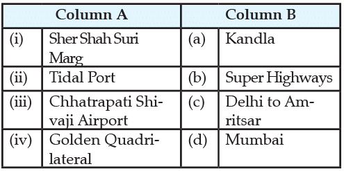
Match the following items given in Column A with those in Column B
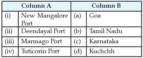
Match the following items given in Column A with those in Column B
Important Questions for Geography Mock Test- 3
Geography Mock Test- 3 MCQs with Answers
Online Tests for Geography Mock Test- 3
|
© EduRev
|
Education Revolution
|


|


