Class 10 Exam  >  Class 10 Tests  >  Geography Mock Test- 4 - Class 10 MCQ

Geography Mock Test- 4 - Class 10 MCQ


Test Description

30 Questions MCQ Test - Geography Mock Test- 4

Geography Mock Test- 4 for Class 10 2025 is part of Class 10 preparation. The Geography Mock Test- 4 questions and answers have been prepared according to the Class 10 exam syllabus.The Geography Mock Test- 4 MCQs are made for Class 10 2025 Exam. Find important definitions, questions, notes, meanings, examples, exercises, MCQs and online tests for Geography Mock Test- 4 below.
Solutions of Geography Mock Test- 4 questions in English are available as part of our course for Class 10 & Geography Mock Test- 4 solutions in Hindi for Class 10 course. Download more important topics, notes, lectures and mock test series for Class 10 Exam by signing up for free. Attempt Geography Mock Test- 4 | 30 questions in 60 minutes | Mock test for Class 10 preparation | Free important questions MCQ to study for Class 10 Exam | Download free PDF with solutions
Geography Mock Test- 4 - Question 1

In which kind of rocks are the minerals deposited and accumulated in the strata's?

Detailed Solution for Geography Mock Test- 4 - Question 1

C is the correct option.Minerals are found in layers or strata in sedimentary rocks. Minerals are accumulated in horizontal strata after being exposed to high heat and pressure for a long period of time. Coal, iron ore, gypsum, potash salt etc are formed in this way.

Geography Mock Test- 4 - Question 2

Which out of the following minerals is formed as a result of evaporation in the arid regions? 

Detailed Solution for Geography Mock Test- 4 - Question 2
Answer:
The mineral that is formed as a result of evaporation in arid regions is Gypsum. Here is a detailed explanation:
Formation of Minerals through Evaporation:
- Evaporation occurs when a liquid is converted into a gas, leaving behind any dissolved minerals or solids.
- In arid regions, where there is limited rainfall and high temperatures, evaporation rates are high.
- As water evaporates, it leaves behind the dissolved minerals, which eventually form minerals through the process of crystallization.
Gypsum Formation:
- Gypsum is a common mineral that forms through the process of evaporation in arid regions.
- It is composed of calcium sulfate dihydrate (CaSO4·2H2O) and has a white or transparent color.
- When water containing dissolved calcium sulfate evaporates, the concentration of calcium sulfate increases, leading to the precipitation of gypsum crystals.
- These crystals can accumulate over time, forming thick layers of gypsum deposits.
Other Options:
- Zinc, coal, and copper are not formed as a result of evaporation in arid regions.
- Zinc is primarily obtained from zinc ores and is not directly formed through evaporation.
- Coal is formed from the remains of plants that lived millions of years ago and underwent a process called carbonization.
- Copper is primarily obtained from copper ores and is not directly formed through evaporation.
Conclusion:
- Gypsum is the mineral that is formed as a result of evaporation in arid regions.
- It forms through the process of crystallization when water containing dissolved calcium sulfate evaporates.
- Zinc, coal, and copper are not formed through evaporation in arid regions.
Geography Mock Test- 4 - Question 3

How much hydroelectric power of the total electricity produced is contributed in India?

Detailed Solution for Geography Mock Test- 4 - Question 3
Hydroelectric Power Contribution in India's Total Electricity Production
India has a significant contribution of hydroelectric power in its total electricity production. Let's analyze the details:
1. Total Electricity Production in India:
- India's total electricity production is a combination of various sources such as thermal, hydro, nuclear, and renewable energy.
- The country has been making efforts to increase the share of renewable energy sources in its total electricity production.
2. Contribution of Hydroelectric Power:
- Hydroelectric power is generated by harnessing the energy of flowing or falling water.
- India has abundant water resources, which makes hydroelectric power a valuable source of renewable energy.
- Hydroelectric power plants are installed across several rivers and dams in the country.
3. Percentage Contribution:
- According to recent data, approximately 22 per cent of India's total electricity production is contributed by hydroelectric power.
- This means that out of the entire electricity generated in India, around 22 per cent comes from hydroelectric plants.
4. Importance of Hydroelectric Power:
- Hydroelectric power is considered a clean and renewable source of energy.
- It helps in reducing greenhouse gas emissions and dependence on fossil fuels.
- Hydroelectric projects also contribute to irrigation, flood control, and overall water management.
Therefore, the correct answer is option A: Approximately 22 per cent of the total electricity produced in India is contributed by hydroelectric power.
Geography Mock Test- 4 - Question 4

Which of the following sedimentary minerals is formed as a result of evaporation, especially in arid regions?

Detailed Solution for Geography Mock Test- 4 - Question 4

Formation of Sedimentary Minerals through Evaporation:
Evaporation is one of the processes that can lead to the formation of sedimentary minerals. When water evaporates, it leaves behind dissolved substances, which can eventually precipitate and form minerals. In arid regions, where evaporation rates are high and water bodies tend to be shallow, the concentration of dissolved minerals increases, leading to the formation of specific minerals.
Identifying the Sedimentary Mineral Formed through Evaporation:
Among the options provided, the sedimentary mineral formed as a result of evaporation, especially in arid regions, is potash salt (option B). Here is a detailed explanation:
- Coal: Coal is a sedimentary rock formed from the remains of plant material, not through evaporation.
- Potash Salt: Potash salt, also known as potassium chloride, is commonly formed through the evaporation of saline water in arid regions. The high concentration of dissolved potassium and chloride ions in the water leads to the precipitation of potash salt.
- Iron Ore: Iron ore is formed through various processes, including sedimentation, and is not specifically associated with evaporation.
- Sulphur: Sulphur can be formed through volcanic activity or as a byproduct of certain chemical reactions, but it is not directly related to evaporation.
Hence, the correct answer is Option B: Potash salt.
Geography Mock Test- 4 - Question 5

Which of the following regions of India contain most of the reserves of coal, metallic minerals, mica and many other non-metallic minerals?

Detailed Solution for Geography Mock Test- 4 - Question 5

D is the correct option.peninsular rocks contain most of the reserves of coal, metallic minerals, mica and many other non-metallic minerals. Sedimentary rocks on the western and eastern flanks of the peninsula, in Gujarat and Assam have most of the petroleum deposits.

Geography Mock Test- 4 - Question 6

Which of the following led to expansion of the fertiliser industry?

Detailed Solution for Geography Mock Test- 4 - Question 6
Answer:
The expansion of the fertilizer industry can be attributed to the following factors:
1. The Green Revolution: The Green Revolution, which took place in the 1960s and 1970s, aimed to increase agricultural productivity through the use of modern farming techniques and technologies. This included the widespread adoption of chemical fertilizers to supplement soil nutrients and enhance crop yields.
2. Liberalization and foreign direct investment (FDI): Liberalization policies and the opening up of economies to foreign direct investment have played a significant role in the expansion of the fertilizer industry. This has allowed for increased investments, technology transfer, and access to global markets, leading to the growth and development of the industry.
3. Multinational corporations (MNCs): Multinational corporations have played a crucial role in the expansion of the fertilizer industry. MNCs have brought in capital, technology, and expertise, leading to the establishment of modern and efficient production facilities. They have also contributed to the distribution and marketing of fertilizers on a global scale.
Overall, the expansion of the fertilizer industry can be attributed to the Green Revolution, liberalization policies, foreign direct investment, and the involvement of multinational corporations. These factors have collectively contributed to the growth, development, and modernization of the industry, leading to increased agricultural productivity and food security.
Geography Mock Test- 4 - Question 7

The earth is occupied mostly with water yet freshwater resources are only

Detailed Solution for Geography Mock Test- 4 - Question 7
The percentage of freshwater resources on Earth
- The Earth is composed mostly of water, with approximately 71% of its surface covered by oceans, seas, and other bodies of saltwater.
- However, freshwater resources, which are essential for human consumption and various other purposes, only make up a small percentage of this total water supply.
- The correct answer is 2.5% (C).
- Here is a detailed explanation of why this is the correct answer:
1. Definition of freshwater:
- Freshwater refers to water that contains a low concentration of dissolved salts.
- It is found in lakes, rivers, underground aquifers, and frozen in glaciers and ice caps.
2. Distribution of Earth's water:
- About 97.5% of the Earth's water is in the form of saltwater, primarily in the oceans.
- Only about 2.5% of the Earth's water is freshwater.
3. Breakdown of freshwater:
- Out of this 2.5% of freshwater, the majority is locked in glaciers and ice caps, making it inaccessible for direct use.
- The remaining freshwater is available in accessible forms such as groundwater, lakes, rivers, and atmospheric water vapor.
4. Availability of usable freshwater:
- Not all of the accessible freshwater is available for immediate use due to various factors such as contamination, seasonal variations, and uneven distribution.
- Of the accessible freshwater, only a small fraction is considered usable for human consumption and other purposes.
5. Conclusion:
- In conclusion, although the Earth is mostly occupied by water, the percentage of usable freshwater resources is relatively low.
- The correct answer to the given question is 2.5% (C), as this represents the proportion of freshwater resources in relation to the total water supply on Earth.
Geography Mock Test- 4 - Question 8

The means for the movement of goods and services from their supply locations to demand locations can be termed as which of the following?

Detailed Solution for Geography Mock Test- 4 - Question 8
Transport system
- The means for the movement of goods and services from their supply locations to demand locations is referred to as the transport system.
- The transport system plays a crucial role in the supply chain and distribution of goods and services.
- It involves the physical movement of products from manufacturers or suppliers to retailers or consumers.
- The transport system includes various modes of transportation such as road, rail, air, and sea.
- Each mode of transportation has its advantages and disadvantages, and the choice of mode depends on factors such as cost, distance, time sensitivity, and type of goods.
- Efficient transportation systems are essential for economic growth and development, as they facilitate trade and commerce.
- The transport system also includes supporting infrastructure such as roads, highways, railways, ports, and airports.
- Technology and logistics management play a significant role in optimizing the transport system and improving efficiency.
- A well-functioning transport system ensures timely delivery of goods and services to meet customer demand.
- It helps in reducing transportation costs, improving accessibility, and reducing environmental impacts.
- Overall, the transport system is a critical component of the supply chain and plays a vital role in connecting supply locations with demand locations.
Geography Mock Test- 4 - Question 9

India has one of the largest networks of which of the following modes of transport?

Detailed Solution for Geography Mock Test- 4 - Question 9
India's Largest Network of Transport Modes
India has one of the largest networks of roadways, railways, waterways, and pipelines. However, the mode of transport with the largest network in India is roadways.
Reasons for India's Extensive Roadway Network:
- Geographical diversity: India's vast and diverse geography, including mountains, plains, and coastal areas, necessitates an extensive road network.
- Connectivity: Roadways provide connectivity to remote areas where other modes of transport may not be feasible.
- Accessibility: Roadways offer convenient accessibility for both passengers and goods transportation.
- Economic activity: Roadways play a crucial role in promoting economic activity by connecting industrial centers, markets, and transportation hubs.
- Rural connectivity: Roadways facilitate rural development by connecting villages to towns and cities, improving access to essential services and amenities.
Advantages of India's Roadway Network:
- Flexibility: Road transport allows for flexible routing and scheduling to serve various destinations.
- Last-mile connectivity: Roadways provide the crucial last-mile connectivity required for door-to-door transportation.
- Cost-effective: Road transport is often more cost-effective for short to medium-distance travel compared to other modes.
- Employment generation: The extensive road network supports employment opportunities in the transportation and logistics sectors.
- Trade facilitation: Road transport enables the efficient movement of goods, contributing to trade and commerce.
In conclusion, India has an extensive network of roadways, which is the largest among all the modes of transport in the country. This road network plays a vital role in connecting people, promoting economic activity, and facilitating trade and development.
Geography Mock Test- 4 - Question 10

Which one of the following soils found in India is the most useful for agriculture?

Detailed Solution for Geography Mock Test- 4 - Question 10
Alluvial soils are by far the largest and the most important soil group of India. Covering about 15 lakh sq km or about 45.6 per cent of the total land area of the country, these soils contribute the largest share of our agricultural wealth and support the bulk of India's population.

Geography Mock Test- 4 - Question 11

The major source of mineral in the soil is the

Detailed Solution for Geography Mock Test- 4 - Question 11
The burning of fossil fuels like coal natural gas, petroleum in automobiles, industries and thermal plants leads to an increase in air pollution.

Geography Mock Test- 4 - Question 12

Utilizing land for a variety of purposes is known as ______.

Detailed Solution for Geography Mock Test- 4 - Question 12
Humans use the land for lots of different things. Utilizing land for a variety of purposes is known as land use. The land is used for various purposes. It is used for residence, agriculture, transport, industries, recreation, etc.

Geography Mock Test- 4 - Question 13

Which one of the following cities has emerged as the ‘electronic capital’ of India?

Detailed Solution for Geography Mock Test- 4 - Question 13
Electronic Capital of India

  • City: Bengaluru


Detailed Explanation

  • IT Hub: Bengaluru is known as the Silicon Valley of India due to its thriving IT industry.

  • Electronic Manufacturing: The city is a hub for electronic manufacturing companies, contributing significantly to the electronics industry in India.

  • Start-up Culture: Bengaluru has a vibrant start-up culture, with numerous tech start-ups choosing the city as their base.

  • Research and Development: The city is home to several research and development centers of multinational electronics companies, further solidifying its position as the electronic capital of India.

Geography Mock Test- 4 - Question 14

How are dams classified based on structure?

Detailed Solution for Geography Mock Test- 4 - Question 14

The correct answer is Option C: Based on Structure and Materials. Dams are classified into categories such as timber dams, embankment dams, or masonry dams based on their structure and the materials used in their construction.

Geography Mock Test- 4 - Question 15

Which of the following industries belongs to the category of heavy industries?

Detailed Solution for Geography Mock Test- 4 - Question 15
Heavy Industries
There are several industries that can be categorized as heavy industries. These industries typically involve the production of large-scale machinery, equipment, and infrastructure. Let's analyze each option to determine which one belongs to the category of heavy industries:
A: Watches
- Watches are not considered heavy industries as they involve the production of small-scale consumer goods.
B: Shipbuilding
- Shipbuilding is a classic example of a heavy industry as it involves the construction of large ships and vessels.
C: Electric bulbs
- Electric bulbs are not considered heavy industries as they involve the production of small-scale consumer goods.
D: Knitting needles
- Knitting needles are not considered heavy industries as they involve the production of small-scale consumer goods.
Conclusion:
Based on the analysis, the industry that belongs to the category of heavy industries is shipbuilding (Option B). This industry involves the construction of large-scale ships and vessels, which aligns with the characteristics of heavy industries.
Geography Mock Test- 4 - Question 16

Which of the following techniques of cotton textile production came into use after the 18th century?

Detailed Solution for Geography Mock Test- 4 - Question 16
Techniques of Cotton Textile Production after the 18th Century:

  • Powerlooms: Powerlooms were introduced in the 19th century and revolutionized the textile industry by mechanizing the weaving process, increasing efficiency, and reducing the reliance on manual labor.

Geography Mock Test- 4 - Question 17

Which out of the following minerals is formed by the decomposition of surface rocks, and leaves a residual mass of weathered material? 

Detailed Solution for Geography Mock Test- 4 - Question 17

B is the correct option.Bauxite is a mineral which is formed by decomposition of rocks, leaving a residual mass of weathered material.

Geography Mock Test- 4 - Question 18

Which out of the following minerals occurs in the sands of valley floors and the base of hills?

Detailed Solution for Geography Mock Test- 4 - Question 18

Certain minerals may occur as alluvial deposits in sands of valley floors and the base of hills. These deposits are called 'placer deposits' and generally contain minerals which are not corroded by water. Gold, silver, tin and platinum are most important among such minerals.

Geography Mock Test- 4 - Question 19

Which of the following is the principal crop grown in areas of Intensive Subsistence Farming?

Detailed Solution for Geography Mock Test- 4 - Question 19

There are two types of the intensive subsistence agriculture. One is dominated by wet paddy and the other is dominated by crops other than paddy, e.g., wheat, pulses, maize, millets, sorghum, kaoling, soya-beans, tubers and vegetables.

Geography Mock Test- 4 - Question 20

Rice is a subsistence crop in Orissa. In which of the following states, is rice a commercial crop?

Detailed Solution for Geography Mock Test- 4 - Question 20

Rice is a commercial crop in Haryana and Punjab, but in Odisha, it is a subsistence crop.

Geography Mock Test- 4 - Question 21

Industries don't cause _____________ pollution.

Detailed Solution for Geography Mock Test- 4 - Question 21

Industries can indeed cause all types of pollution mentioned:

- Air Pollution: Industries emit pollutants like carbon monoxide, sulfur dioxide, and particulate matter into the atmosphere.
- Water Pollution: Industrial waste can contaminate water bodies, introducing toxic chemicals and disrupting ecosystems.
- Noise Pollution: Industrial operations often involve machinery and processes that produce significant noise.

Thus, industries contribute to air, water, and noise pollution, making "D: all of the above" the correct answer.

Geography Mock Test- 4 - Question 22

Which of the following means of transportation is used to transportmcrude oil, petroleum products and natural gas?

Detailed Solution for Geography Mock Test- 4 - Question 22

Crude oil, petroleum products, and natural gas are transported through various means of transportation. The most common method used for transporting these resources is through pipelines.
Pipelines:
- Pipelines are a network of interconnected pipes that transport liquids and gases over long distances.
- They are the safest and most efficient way to transport crude oil, petroleum products, and natural gas.
- Pipelines can transport large volumes of oil and gas, making them ideal for long-distance transportation.
- They are cost-effective and have a lower environmental impact compared to other means of transportation.
Other means of transportation that are used to transport crude oil, petroleum products, and natural gas include:
Roadways:
- Tanker trucks are used to transport small quantities of oil and gas over short distances.
- Roadways are commonly used for local transportation and delivery of petroleum products.
Railways:
- Rail tank cars are used to transport larger quantities of oil and gas over longer distances.
- Railways are commonly used for intercity transportation of petroleum products.
Waterways:
- Tankers and barges are used to transport large quantities of oil and gas over long distances.
- Waterways, such as rivers, canals, and seas, are commonly used for international transportation of petroleum products.
In conclusion, while roadways, railways, and waterways are used to transport crude oil, petroleum products, and natural gas, pipelines are the primary and most efficient means of transportation for these resources.
Geography Mock Test- 4 - Question 23

Which of the following networks of pipeline bring mineral oil to the refinery of Barauni and petrochemical complex of Haldia?

Detailed Solution for Geography Mock Test- 4 - Question 23

The correct answer is A as  There are three important networks of pipeline transportation in the country.  From oil field in upper Assam to Kanpur (Uttar Pradesh), via Guwahati, Barauni and Allahabad. It has branches from Barauni to Haldia, via Rajbandh, Rajbandh to Maurigram and Guwahati to Siliguri.

Geography Mock Test- 4 - Question 24

Which of the following modes of transport is fuel efficient and environment friendly?

Detailed Solution for Geography Mock Test- 4 - Question 24
Waterways is the most fuel efficient and environment friendly mode of transport among the options given.
Explanation:
1. Fuel efficiency:
- Waterways, such as rivers, canals, and oceans, provide a natural infrastructure for transportation, requiring minimal energy for propulsion.
- Ships and boats can transport a large amount of cargo or passengers using relatively small amounts of fuel compared to other modes of transport.
- Waterways allow for the use of efficient engines and propellers, contributing to fuel efficiency.
2. Environment friendly:
- Water transportation produces lower emissions compared to other modes. Ships and boats generally emit less greenhouse gases per ton of cargo compared to trucks, airplanes, or trains.
- Waterways have less impact on land ecosystems as they do not require extensive construction or deforestation.
- Water transportation also reduces traffic congestion on roads, leading to lower air pollution in urban areas.
3. Economic benefits:
- Waterways can be a cost-effective mode of transport for bulky goods over long distances, reducing transportation costs for businesses and consumers.
- Water transportation can support trade and economic development by providing access to remote areas and connecting different regions.
In summary, waterways are fuel efficient, environmentally friendly, and economically advantageous, making them the best choice among the given options.
Geography Mock Test- 4 - Question 25

“The species that are not found after searches of known or likely areas where they may occur” are known as: 

Detailed Solution for Geography Mock Test- 4 - Question 25

Extinct Species: Furthermore, there are some extinct species. This includes species which are not found after searches of known or likely areas where they may occur. For example, the Asiatic cheetah, pink head duck etc.

Geography Mock Test- 4 - Question 26

Which one of the following is a medicinal plant used to treat some types of cancer? 

Detailed Solution for Geography Mock Test- 4 - Question 26

The Himalayan Yew is a medicinal plant found in various parts of Himachal Pradesh and Arunachal Pradesh in the Himalayan region. A chemical compound called ‘taxol’ is extracted from its bark, needles, twigs and roots. This has been successfully used to treat some types of cancers. The species is, therefore, over-utilised for manufacturing cancer fighting drug. The drug is now the biggest selling anti-cancer drug in the world. The species of Himalayan Yew is, therefore, under great threat due to over-exploitation on account of its medicinal value.

Geography Mock Test- 4 - Question 27

Find the incorrect option:

Detailed Solution for Geography Mock Test- 4 - Question 27
The National Highway 1 in India connects Delhi and Amritsar. This highway is named after the founder of the Suri Empire which ruled the northern parts of India.
Geography Mock Test- 4 - Question 28

Which of the following was the first port to be developed soon after Independence?

Detailed Solution for Geography Mock Test- 4 - Question 28
The first port to be developed soon after Independence:
The correct answer is D: Kandla. Here is a detailed explanation:
1. Introduction:
After India gained its independence in 1947, the country focused on developing its infrastructure, including ports, to facilitate trade and economic growth. One of the first ports to be developed during this time was Kandla.
2. Kandla Port:
Kandla Port is located in the Kutch district of Gujarat, India. It was established in 1950 as the first all-weather port in the country. The port was developed to cater to the needs of the growing trade and industrial activities in the region.
3. Importance:
Kandla Port played a crucial role in boosting India's international trade. It provided a gateway for the import and export of various commodities, including petroleum, chemicals, iron ore, coal, and textiles. The port's strategic location on the western coast of India made it easily accessible for trade with countries in the Middle East, Africa, and Europe.
4. Growth and Expansion:
Over the years, Kandla Port has witnessed significant growth and expansion. It has been modernized and equipped with advanced infrastructure and facilities to handle larger vessels and increase cargo handling capacity. The port has multiple terminals for different types of cargo, including bulk, container, and liquid cargo.
5. Special Economic Zone:
Kandla Port also houses a Special Economic Zone (SEZ), which promotes industrial development and exports. The SEZ provides various incentives and benefits to businesses, attracting both domestic and international investments.
6. Conclusion:
In summary, Kandla was the first port to be developed soon after India's independence. It played a vital role in facilitating international trade and promoting economic growth in the country. Over the years, the port has grown and expanded, becoming a major hub for trade and industrial activities.
Geography Mock Test- 4 - Question 29

Which of the following is the oldest artificial port and the second most important port of the country?

Detailed Solution for Geography Mock Test- 4 - Question 29

It is the second largest port in terms of volume of traffic handled and is the oldest artificial harbour on the east coast of India. It handles petroleum products, crude oil, fertilisers, iron ore and dry cargo.

Geography Mock Test- 4 - Question 30

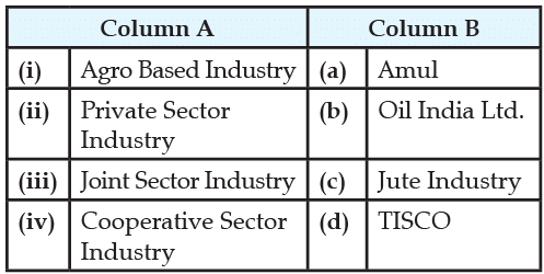
Match the followings item given in Column A with those in Column B:

Detailed Solution for Geography Mock Test- 4 - Question 30

(i) Agro based industry: The cotton textile industry is known as an agro based industry because it uses raw materials produced by the agricultural sector.

(ii) Private sector industry: Tata Steel was established in India as Asia's first integrated private steel company in 1907. With this, we also developed India's first industrial city at Jamshedpur. Today, we are among the leading global steel companies.

(iii) Joint Sector Industry: Oil India limited is jointly owned by the public and private sector, hence it is a joint sector industry.

(iv) Cooperative sector industry: The Amul Model of dairy development is a three-tiered structure with the dairy cooperative societies at the village level federated under a milk union at the district level and a federation of member unions at the state level.

Information about Geography Mock Test- 4 Page
In this test you can find the Exam questions for Geography Mock Test- 4 solved & explained in the simplest way possible. Besides giving Questions and answers for Geography Mock Test- 4, EduRev gives you an ample number of Online tests for practice
Download as PDF