Class 9 Exam  >  Class 9 Tests  >  Social Studies (SST) Class 9  >  Important Questions (1 mark): Size And Location - Class 9 MCQ

Important Questions (1 mark): Size And Location - Class 9 MCQ


Test Description

20 Questions MCQ Test Social Studies (SST) Class 9 - Important Questions (1 mark): Size And Location

Important Questions (1 mark): Size And Location for Class 9 2024 is part of Social Studies (SST) Class 9 preparation. The Important Questions (1 mark): Size And Location questions and answers have been prepared according to the Class 9 exam syllabus.The Important Questions (1 mark): Size And Location MCQs are made for Class 9 2024 Exam. Find important definitions, questions, notes, meanings, examples, exercises, MCQs and online tests for Important Questions (1 mark): Size And Location below.
Solutions of Important Questions (1 mark): Size And Location questions in English are available as part of our Social Studies (SST) Class 9 for Class 9 & Important Questions (1 mark): Size And Location solutions in Hindi for Social Studies (SST) Class 9 course. Download more important topics, notes, lectures and mock test series for Class 9 Exam by signing up for free. Attempt Important Questions (1 mark): Size And Location | 20 questions in 30 minutes | Mock test for Class 9 preparation | Free important questions MCQ to study Social Studies (SST) Class 9 for Class 9 Exam | Download free PDF with solutions
Important Questions (1 mark): Size And Location - Question 1

The eastern-most longitude of India is

Detailed Solution for Important Questions (1 mark): Size And Location - Question 1

The eastern-most longitude of India is 97°25′E. This longitude marks the point known as Kibithu in the northeastern state of Arunachal Pradesh, making it the easternmost extent of India's mainland.

Important Questions (1 mark): Size And Location - Question 2

Which geographical feature forms the boundary between Sri Lanka and India?

Detailed Solution for Important Questions (1 mark): Size And Location - Question 2

The Palk Strait is the narrow channel of sea that separates Sri Lanka from India. This significant water body has played a crucial role in defining the geographical boundaries between the two nations, facilitating trade and cultural exchanges over the centuries.

1 Crore+ students have signed up on EduRev. Have you? Download the App
Important Questions (1 mark): Size And Location - Question 3

Which of the following has reduced India’s distance from Europe by 7000 km?

Detailed Solution for Important Questions (1 mark): Size And Location - Question 3

The Suez Canal has reduced India's distance from Europe by 7000 km by providing a shorter maritime route, allowing ships to bypass the lengthy journey around the southern tip of Africa.

Important Questions (1 mark): Size And Location - Question 4
Which ocean does the Deccan Peninsula extend into?
Detailed Solution for Important Questions (1 mark): Size And Location - Question 4
The Deccan Peninsula extends into the Indian Ocean. This geographical feature provides India with a strategic maritime position, facilitating trade and cultural exchanges with other regions.
Important Questions (1 mark): Size And Location - Question 5

which option is correct about India's geographical and historical attributes:
(i) India is located entirely in the Northern Hemisphere.
(ii) The Tropic of Cancer divides the country into almost two equal parts.
(iii) The southernmost point of the Indian Union is known as Indira Point.
(iv) India's land mass covers an area of 3.28 million square km.

Detailed Solution for Important Questions (1 mark): Size And Location - Question 5
  • Statement (i): Correct. India lies entirely in the Northern Hemisphere.
  • Statement (ii): Incorrect. The Tropic of Cancer does not divide India into two equal parts. It passes through the middle of the country but does not create two equal halves.
  • Statement (iii): Correct. The southernmost point of the Indian Union is Indira Point, which got submerged during the 2004 Tsunami.
  • Statement (iv): Correct. India's land mass covers an area of 3.28 million square km.

Therefore, the correct statements are (i), (ii), and (iv).

Important Questions (1 mark): Size And Location - Question 6
Choose the correctly matched pair.
Detailed Solution for Important Questions (1 mark): Size And Location - Question 6
  • Option A: Standard Meridian of India - 82°30'E: This is correctly matched. The Standard Meridian of India is indeed 82°30'E, which passes through Mirzapur in Uttar Pradesh and is used to set the standard time for the entire country.
  • Option B: Eastern Coast of India - Arabian Sea: This is incorrectly matched. The eastern coast of India is bounded by the Bay of Bengal, not the Arabian Sea. The Arabian Sea is on the western coast of India.
  • Option C: Kanniyakumari - Time Lag of Two Hours: This is incorrectly matched. The time lag of two hours is observed between Gujarat in the west and Arunachal Pradesh in the east due to their longitudinal difference. Kanniyakumari, located at the southern tip of India, does not experience this specific time lag.
  • Option D: Deccan Peninsula - Northern Hemisphere: This is incorrect in the context provided. While the Deccan Peninsula is indeed in the Northern Hemisphere, the more relevant description is its protrusion into the Indian Ocean, which helps India establish contact with various regions.
Important Questions (1 mark): Size And Location - Question 7

Both the latitudinal and longitudinal extent of India’s mainland is about 30°. But on looking at the map of India which of the following alternatives do you observe about India’s size?
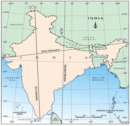
Detailed Solution for Important Questions (1 mark): Size And Location - Question 7

Although India's mainland has approximately equal latitudinal and longitudinal extents of about 30° each, on a map, India appears to have a smaller east-west extent compared to its north-south extent. This is because of the distortion caused by the projection method used to represent the curved surface of the Earth on a flat map, which exaggerates the north-south extent and compresses the east-west extent towards the poles.

Important Questions (1 mark): Size And Location - Question 8

The Tropic of Cancer does not pass through

Detailed Solution for Important Questions (1 mark): Size And Location - Question 8

The Tropic of Cancer passes through Rajasthan, Chhattisgarh, and Tripura, but it does not pass through Odisha (formerly spelt as Orissa). This imaginary line of latitude marks the northernmost point where the sun appears directly overhead at least once during the year.

Important Questions (1 mark): Size And Location - Question 9

Choose the incorrectly matched pair:

Detailed Solution for Important Questions (1 mark): Size And Location - Question 9
  • Option A: Maldives - South of Lakshadweep Islands
    Correct. The Maldives are located to the south of the Lakshadweep Islands.

  • Option B: India - Shares border with Thailand
    Incorrect. India does not share a border with Thailand. The countries that share a border with India are Pakistan, China, Nepal, Bhutan, Bangladesh, and Myanmar.

  • Option C: India - Shares border with Myanmar
    Correct. India shares a border with Myanmar.

  • Option D: Sri Lanka - Separated from India by a narrow channel of sea formed by the Palk Strait and the Gulf of Mannar
    Correct. Sri Lanka is separated from India by the Palk Strait and the Gulf of Mannar.

Therefore, Option B is the correctly identified incorrectly matched pair.

Important Questions (1 mark): Size And Location - Question 10
Which of the following is not a Union Territory of India?
Detailed Solution for Important Questions (1 mark): Size And Location - Question 10
Kerala is a state, not a Union Territory. Union Territories such as Andaman and Nicobar Islands, Puducherry, and Jammu and Kashmir are directly governed by the central government, each having different administrative arrangements compared to states.
Important Questions (1 mark): Size And Location - Question 11

Which of the following groups of islands belonging to the Indian territory lies in the Arabian Sea?

Detailed Solution for Important Questions (1 mark): Size And Location - Question 11

The group of islands belonging to the Indian territory that lies in the Arabian Sea is Lakshadweep. These islands are situated in the Arabian Sea, to the west of the Indian mainland, and are part of the Union Territory of India.

Important Questions (1 mark): Size And Location - Question 12
How does the east-west extent of India compare to its north-south extent?
Detailed Solution for Important Questions (1 mark): Size And Location - Question 12
The east-west extent of India is smaller than its north-south extent. This variation affects how daylight and darkness are experienced across the country, as the north-south stretch is greater, leading to more pronounced differences in day and night durations between northern and southern regions.
Important Questions (1 mark): Size And Location - Question 13

Choose the correctly matched pair.

Detailed Solution for Important Questions (1 mark): Size And Location - Question 13
  • Option A: Tropic of Cancer - 23° 30'N
    This option is correctly matched because the Tropic of Cancer does indeed pass through India at 23° 30'N latitude.
  • Option B: Arunachal Pradesh (Incorrect): The westernmost point of India is actually located in the Gujarat state, near the Guhar Moti in the Kutch region, not in Arunachal Pradesh.
  • Option C: Total area of India - 2.8 million square km
    This option is incorrectly matched.
    The total area of India is approximately 3.28 million square km, not 2.8 million square km.
  • Option D: Main land of India extends between longitudes
    This is incorrect.
    The mainland of India extends between latitudes 8°4' N and 37°6'N and longitudes 68°7' E and 97°25'E.
Important Questions (1 mark): Size And Location - Question 14

Uttarakhand, Uttar Pradesh, Bihar, West Bengal and Sikkim have common frontiers with

Detailed Solution for Important Questions (1 mark): Size And Location - Question 14
  • These states have common frontiers with Nepal.
  • Uttarakhand shares its northern boundary with Nepal.
  • Uttar Pradesh, Bihar, and West Bengal share their northern boundaries with Nepal.
  • Sikkim shares its western boundary with Nepal.
  • These states have important trade and cultural ties with Nepal due to their shared borders. 
Important Questions (1 mark): Size And Location - Question 15

Which state experiences the sun rising two hours earlier compared to Gujarat but showing the same time on watches?

Detailed Solution for Important Questions (1 mark): Size And Location - Question 15

In Arunachal Pradesh, the sun rises earlier due to its eastern location in the Indian time zone compared to Gujarat in the west, but the watches show the same time because the Indian Standard Time is maintained uniformly across the country, despite significant longitudinal differences. This practice ensures a standardized time system throughout India.

Important Questions (1 mark): Size And Location - Question 16

If you intend to visit Kavarati during your summer vacations, which one of the following Union Territories of India you will be going to?

Detailed Solution for Important Questions (1 mark): Size And Location - Question 16

Kavarati is the capital of Lakshadweep, a Union Territory of India. It is a group of islands located in the Arabian Sea, known for its pristine beaches and coral reefs. If you plan to visit Kavaratti during your summer vacations, you'll be heading to the beautiful islands of Lakshadweep.

Important Questions (1 mark): Size And Location - Question 17

Which of the following is the longitudinal extent of India?

Detailed Solution for Important Questions (1 mark): Size And Location - Question 17

According to latitudes, India is in Northern Hemisphere. It extends between 8°4′N to 37°6′N. Its southern extent is 8°4′N and northern extent is 37°6′N. According to longitudes, India is in Eastern Hemisphere. It extends between 68°7′ E to 97°25′E.

Important Questions (1 mark): Size And Location - Question 18

Which latitude passes through the southern-most point of India’s mainland?

Detailed Solution for Important Questions (1 mark): Size And Location - Question 18

The latitude that passes through the southern-most point of India's mainland is 8°4′N. This latitude line marks the southernmost extent of India's mainland, reaching its lowest point at the tip of the Indian peninsula in Kanyakumari, Tamil Nadu.

Important Questions (1 mark): Size And Location - Question 19

My friend hails from a country which does not share land boundary with India. Identify the country.

Detailed Solution for Important Questions (1 mark): Size And Location - Question 19
  • Tajikistan is the country that does not share a land boundary with India.

  • Tajikistan is located in Central Asia, bordered by Afghanistan to the south, Uzbekistan to the west, Kyrgyzstan to the north, and China to the east.

  • India does not share a direct land boundary with Tajikistan.

  • Therefore, if your friend hails from Tajikistan, it is a country that does not share a land boundary with India.
Important Questions (1 mark): Size And Location - Question 20

What ancient trade routes contributed to the exchange of ideas and commodities since ancient times?

Detailed Solution for Important Questions (1 mark): Size And Location - Question 20
  • The ancient trade routes, such as the Silk Road, played a crucial role in facilitating the exchange of ideas and commodities between different regions.
  • The Silk Road was a network of trade routes connecting the East and West, enabling the flow of goods, technologies, and cultural influences.
52 videos|437 docs|80 tests
Information about Important Questions (1 mark): Size And Location Page
In this test you can find the Exam questions for Important Questions (1 mark): Size And Location solved & explained in the simplest way possible. Besides giving Questions and answers for Important Questions (1 mark): Size And Location, EduRev gives you an ample number of Online tests for practice

Top Courses for Class 9

52 videos|437 docs|80 tests
Download as PDF

Top Courses for Class 9