Indian Air Force Agniveer Vayu Exam  >  Indian Air Force Agniveer Vayu Tests  >  Indian Air Force Agniveer Vayu Group X Mock Test Series 2025  >  Indian Air Force Agniveer Science Subject Mock Test - 8 - Indian Air Force Agniveer Vayu MCQ

Indian Air Force Agniveer Science Subject Mock Test - 8 - Indian Air Force Agniveer Vayu MCQ


Test Description

30 Questions MCQ Test Indian Air Force Agniveer Vayu Group X Mock Test Series 2025 - Indian Air Force Agniveer Science Subject Mock Test - 8

Indian Air Force Agniveer Science Subject Mock Test - 8 for Indian Air Force Agniveer Vayu 2025 is part of Indian Air Force Agniveer Vayu Group X Mock Test Series 2025 preparation. The Indian Air Force Agniveer Science Subject Mock Test - 8 questions and answers have been prepared according to the Indian Air Force Agniveer Vayu exam syllabus.The Indian Air Force Agniveer Science Subject Mock Test - 8 MCQs are made for Indian Air Force Agniveer Vayu 2025 Exam. Find important definitions, questions, notes, meanings, examples, exercises, MCQs and online tests for Indian Air Force Agniveer Science Subject Mock Test - 8 below.
Solutions of Indian Air Force Agniveer Science Subject Mock Test - 8 questions in English are available as part of our Indian Air Force Agniveer Vayu Group X Mock Test Series 2025 for Indian Air Force Agniveer Vayu & Indian Air Force Agniveer Science Subject Mock Test - 8 solutions in Hindi for Indian Air Force Agniveer Vayu Group X Mock Test Series 2025 course. Download more important topics, notes, lectures and mock test series for Indian Air Force Agniveer Vayu Exam by signing up for free. Attempt Indian Air Force Agniveer Science Subject Mock Test - 8 | 70 questions in 60 minutes | Mock test for Indian Air Force Agniveer Vayu preparation | Free important questions MCQ to study Indian Air Force Agniveer Vayu Group X Mock Test Series 2025 for Indian Air Force Agniveer Vayu Exam | Download free PDF with solutions
Indian Air Force Agniveer Science Subject Mock Test - 8 - Question 1

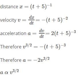
A particle moves a distance x in time t according to equation x = (t + 5)-1. The acceleration of particle is proportional to [2010]

Detailed Solution for Indian Air Force Agniveer Science Subject Mock Test - 8 - Question 1

Indian Air Force Agniveer Science Subject Mock Test - 8 - Question 2

Free fall of an object in vacuum is a case of motion with

Detailed Solution for Indian Air Force Agniveer Science Subject Mock Test - 8 - Question 2

Free fall of an object in vacuum is a case of motion with uniform acceleration.

Indian Air Force Agniveer Science Subject Mock Test - 8 - Question 3

A body under the action of a force  
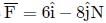
acquiring an acceleration of 5ms−2. The mass of the body is 

Detailed Solution for Indian Air Force Agniveer Science Subject Mock Test - 8 - Question 3

Given: and a = 5ms−2
∴ 
Mass of the body is, m = F/a
= 10N / 5ms−2
= 2 kg

Indian Air Force Agniveer Science Subject Mock Test - 8 - Question 4

Ten one rupee coins are put on top of each other on a table. Each coin has a mass m. The reaction of the 6th coin (counted from the bottom) on the 7th coin is 

Detailed Solution for Indian Air Force Agniveer Science Subject Mock Test - 8 - Question 4

The sixth coin is under the weight of four coins baove it. Hence,
Reaction of the 6th coin on the 7th coin = Force on the 6th coin due to 7th coin
= 4mg

Indian Air Force Agniveer Science Subject Mock Test - 8 - Question 5

What pulls a ball back to earth?

Detailed Solution for Indian Air Force Agniveer Science Subject Mock Test - 8 - Question 5

The gravitational force of the earth acts on every object having mass. When a ball is thrown upwards the gravitational force of the earth acts against the velocity of the object and pulls the ball downwards, i.e, towards itself.

Thus, gravity pulls a ball back to earth.

Indian Air Force Agniveer Science Subject Mock Test - 8 - Question 6

In Geiger-Marsden experiment very small deflection of the beam was expected because

Detailed Solution for Indian Air Force Agniveer Science Subject Mock Test - 8 - Question 6

In the Geiger-Marsden experiment very small deflection of the beam was expected because positive charge and the negative electrons are distributed through the whole atom reducing electric field inside the atom.

Indian Air Force Agniveer Science Subject Mock Test - 8 - Question 7

What is the sign of the sinA and tanA in third quadrant respectively

Detailed Solution for Indian Air Force Agniveer Science Subject Mock Test - 8 - Question 7

The sign of the sinA and tanA in third quadrant is negative and positive.

Indian Air Force Agniveer Science Subject Mock Test - 8 - Question 8

 is equal to

Detailed Solution for Indian Air Force Agniveer Science Subject Mock Test - 8 - Question 8

Let y = tan−1[(a−x)/(a+x)]1/2
put x = a cos θ
Now, y = tan−1[(a − a cos θ)/(a + a cos θ)]1/2
⇒ y = tan−1((1 − cos θ)/(1 + cos θ))1/2
⇒ y = tan−1[[(1−cos θ)(1−cos θ)]/(1+cos θ)(1−cos θ)]1/2
⇒ y = tan−1[(1−cos θ)2/1 − cos2θ]1/2
⇒ y = tan−1[(1 − cos θ)/sin θ]
⇒ y = tan−1[2 sin2(θ/2)/2 sin(θ/2) . cos(θ/2)]
⇒ y = tan−1[tan(θ/2)]
⇒ y = θ/2
⇒ y = 1/2 cos−1(x/a)

Indian Air Force Agniveer Science Subject Mock Test - 8 - Question 9

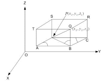
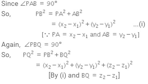
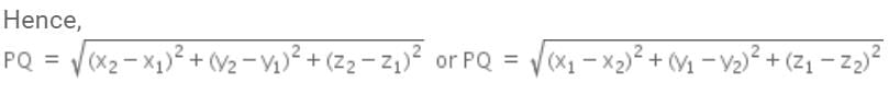
The distance between the points P(x1, y1, z1) and Q (x2, y2, z2) is given by:

Detailed Solution for Indian Air Force Agniveer Science Subject Mock Test - 8 - Question 9


Indian Air Force Agniveer Science Subject Mock Test - 8 - Question 10

If  = c. Find c.

Detailed Solution for Indian Air Force Agniveer Science Subject Mock Test - 8 - Question 10

18P4/18C4
⇒ [18!/14!]/[18!/(4!*14!)]
⇒ 4!
⇒ 24

Indian Air Force Agniveer Science Subject Mock Test - 8 - Question 11

Detailed Solution for Indian Air Force Agniveer Science Subject Mock Test - 8 - Question 11

Indian Air Force Agniveer Science Subject Mock Test - 8 - Question 12

Point (-2, – 5) lies on the circle x2 + y2 = 25.

Detailed Solution for Indian Air Force Agniveer Science Subject Mock Test - 8 - Question 12

X2 +Y2 =25    Points =(-2,-5)
Put the points in the variables
(-2)2 + (-5)2 = 29
As 29 > 25  (lies outside).

Indian Air Force Agniveer Science Subject Mock Test - 8 - Question 13

Directions: Study the given information carefully to answer the question that follows:

In a college, there are 2400 students studying in different branches - Electronics, Mechanical, Electrical, IT, and Computer Science. The ratio of the number of boys to that of girls is 5 : 3. 12% boys study in the Electronics branch. 24% girls study in the Mechanical branch. The ratio of the number of boys to that of girls in the Electronics branch is 6 : 11. One-ninth of girls study in the Computer Science branch. 42% boys study in the IT branch. The number of girls studying in the IT branch is 10% of the boys studying in the same branch. The remaining girls study in the Electrical branch. The total number of students studying in the Computer Science branch is 285. 22% boys study in the Electrical branch. The remaining boys study in the Mechanical branch.

Q. What is the total number of girls studying in the Electronics and Electrical branches?

Detailed Solution for Indian Air Force Agniveer Science Subject Mock Test - 8 - Question 13

Total number of students = 2400
Ratio of the number of boys to that of girls = 5 : 3
Number of boys = (5/8) × 2400 = 1500
Number of girls = (3/8) × 2400 = 900
12% boys studying in Electronics = 12% of 1500 = 180
24% girls studying in Mechanical = 24% of 900 = 216
Ratio of the number of boys to that of girls in Electronics = 6 : 11
Number of girls studying in Electronics = 11 × 30 = 330 [Number of boys studying in Electronics = 180]
One-ninth of girls studying in Computer Science = (1/9) × (900) = 100
42% boys studying in IT = 42% of 1500 = 630
The number of girls studying in IT is 10% of the boys studying in the same branch = 10% of 630 = 63
The remaining girls are studying in Electrical = 900 - (216 + 330 + 100 + 63) = 191
Total number of students studying in Computer Science = 285
Number of boys studying in Computer science branch = 285 - 100 = 185
22% boys studying in Electrical = 22% of (1500) = 330
Number of boys studying in Mechanical = 1500 - (180 + 100 + 630 + 185 + 330) = 75
Total number of girls studying in Electronics and Electrical = 330 + 191 = 521

Indian Air Force Agniveer Science Subject Mock Test - 8 - Question 14


Detailed Solution for Indian Air Force Agniveer Science Subject Mock Test - 8 - Question 14

Indian Air Force Agniveer Science Subject Mock Test - 8 - Question 15

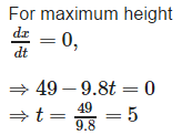
The stone projected vertically upwards moves under the action of gravity alone and its motion is described by x = 49 t – 4.9 t2 . It is at a maximum height when

Detailed Solution for Indian Air Force Agniveer Science Subject Mock Test - 8 - Question 15

Indian Air Force Agniveer Science Subject Mock Test - 8 - Question 16

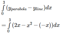
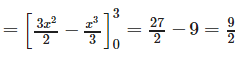
The area bounded by the curve y = 2x - x2 and the line x + y = 0 is

Detailed Solution for Indian Air Force Agniveer Science Subject Mock Test - 8 - Question 16

The equation y = 2x − x2 i.e. y – 1 = - (x - 1)2 represents a downward parabola with vertex at (1, 1) which meets x – axis where y = 0 .i .e . where x = 0 , 2. Also , the line y = - x meets this parabola where – x = 2x − x2 i.e. where x = 0 , 3. 
Therefore , required area is :

Indian Air Force Agniveer Science Subject Mock Test - 8 - Question 17

The number of arbitrary constants in the general solution of a differential equation of fourth order are:

Detailed Solution for Indian Air Force Agniveer Science Subject Mock Test - 8 - Question 17

4 , because the no. of arbitrary constants is equal to order of the differential equation.

Indian Air Force Agniveer Science Subject Mock Test - 8 - Question 18

The direction of zero vector.​

Detailed Solution for Indian Air Force Agniveer Science Subject Mock Test - 8 - Question 18

Zero vector is the unit vector having zero length, hence the direction is undefined.

Indian Air Force Agniveer Science Subject Mock Test - 8 - Question 19

The stuents were / awating for / the arrival of the chief guest / No error.

Detailed Solution for Indian Air Force Agniveer Science Subject Mock Test - 8 - Question 19

The verb await itself means to wait for somebody/something. Therefore, in option B either remove "for" after awaiting or replace "awaiting" with "waiting".

Indian Air Force Agniveer Science Subject Mock Test - 8 - Question 20

Sixty miles / are / a good distance / No error.

Detailed Solution for Indian Air Force Agniveer Science Subject Mock Test - 8 - Question 20

The sentence "Sixty miles are a good distance" is incorrect. It should be "Sixty miles is a good distance" because "sixty miles" is considered a singular quantity. Therefore, the error is in part 2.

So, the correct choice is:

2.   Are.

Indian Air Force Agniveer Science Subject Mock Test - 8 - Question 21

Find  the word most appropriate for Blank no.  29

Our study about women’s place in Indian society is mainly based on urban, professional and educated Indian women. Deep in the rural heartland of the country, the rapidly changing world has not even touched the (29)____ of the life of a women. Most men of orthodox families take (30)____ in revealing that their (31)____ folk stay in ‘purdah’, a shield that (32)____ a woman of the joys of free nature. Still more alarming are the (33)____ of atrocities of women (34)____ incidents at Bantala, Singur and Birati are (35)____

Detailed Solution for Indian Air Force Agniveer Science Subject Mock Test - 8 - Question 21

Fringe means on the outer edge (of something).
Thus it is the most suitable word from all other options.

Indian Air Force Agniveer Science Subject Mock Test - 8 - Question 22

Although the initial setup of generators and a power grid by Edison and JP Morganwas rather costly, the electrification of lighting in lower Manhattan doubled work efficiency when the energy costs were cut in half.

Detailed Solution for Indian Air Force Agniveer Science Subject Mock Test - 8 - Question 22

Choice C has an incorrect idiom: while as. Choices A, C, & D have passive constructions in the last part of the options. A also unnecessarily has ‘the’ before ‘energy costs’. This word is needed or the meaning of the sentence would be altered. Choice B is the correct answer.

Indian Air Force Agniveer Science Subject Mock Test - 8 - Question 23

Because the economic cycle in the United States changes little during its 20-yearinterval between recessing, it is fairly easy for analysts to predict analogous trendsin the stock market.

Detailed Solution for Indian Air Force Agniveer Science Subject Mock Test - 8 - Question 23

The word ‘interval’ is critical in this sentence. You might want to ask yourself why use the word ‘between’ at all? You need the word because of the word ‘interval’. ‘Interval’ implies that something is happening. That something has two parts to it. ‘Interval between’ is the correct idiomatic expression. A is incorrect because it uses the verb form ‘recessing’, which is not connected to a recession in the economy. This type of recession is what the sentence is discussing. Choice C is the best answer.

Indian Air Force Agniveer Science Subject Mock Test - 8 - Question 24

Directions: In the given statements, a blank has been given. This needs to be filled up using the correct combination of words from the three options mentioned, so that the resulting statement is grammatically and contextually correct.

In the ancient times, remaining alone was dangerous as _______________ animals could easily attack its solitary prey.

I. domesticated
II. wild
III. herbivorous

Detailed Solution for Indian Air Force Agniveer Science Subject Mock Test - 8 - Question 24

Domesticated: (of an animal) tame and kept as a pet or on a farm
Herbivorous: (of an animal) feeding on plants
“Domesticated” and “herbivorous” animals would not attack people. Even if they attack for some
reason, they would not consider humans their ‘prey’.
Hence, these two words get eliminated.
Only the word “wild” fits perfectly in the blank. “Wild” animals would consider humans as ‘prey’ and
attack them too.
Hence, option B is the correct answer.

Indian Air Force Agniveer Science Subject Mock Test - 8 - Question 25

Which one best expresses the given sentence in Passive/Active Voice?

Has someone made all the necessary arrangements?

Detailed Solution for Indian Air Force Agniveer Science Subject Mock Test - 8 - Question 25

This sentence is in the active voice, with the subject "someone" performing the action of making the necessary arrangements. To convert it to the passive voice, the object of the verb (the necessary arrangements) becomes the subject of the sentence, and the verb is changed to its past participle form (been made). The preposition "by" is added to indicate who performed the action.

Option (c) correctly expresses the sentence in the passive voice. Option (a) and (b) are incorrect because they use incorrect word order, and option (d) is in the active voice, with the subject "one" performing the action.

Indian Air Force Agniveer Science Subject Mock Test - 8 - Question 26

Direction: The sentences given in the question, when properly sequenced, form a coherent paragraph. Each sentence is labeled with a letter. Choose the most logical order of sentences from the given choices to construct a coherent paragraph.

A. As people turned to farming, they began to live in fixed settlements, which became small towns.

B. Their labors bore fruit; surplus food freed some of the population from farming.

C. In about 5000 BC, farmers moved down into the fertile river valleys of Mesopotamia, and built dykes and ditches to irrigate the arid land.

D. The cultivation of plants, such as wheat and barley, and the domestication of animals, such as sheep, goats and cattle, began in the Near East in about 8500 BC.

Detailed Solution for Indian Air Force Agniveer Science Subject Mock Test - 8 - Question 26

By timeline, 8500 BC was before 5000 BC. So sentence C is likely to feature after sentence D in the paragraph.

Sentence D talks of cultivation of plants and domestication of animals that began in the Near East around 8500 BC. Sentence A carries this idea forward, explaining how fixed settlements and small towns came into being after people turned to farming.

Sentence B starts off with “their labors"?. Who does “their"? refer to? Sentence C, which talks of farmers who moved down to the river valleys of Mesopotamia and their efforts to build dykes and ditches, has the answer. So B follows C.

DACB makes a cogent paragraph.

The question is " Arrange the sentences in the correct order "
The order is DACB

Hence, the answer is DACB
Choice A is the correct answer.

Indian Air Force Agniveer Science Subject Mock Test - 8 - Question 27

Direction: The sentences given in the question, when properly sequenced, form a coherent paragraph. Each sentence is labeled with a letter. Choose the most logical order of sentences from the given choices to construct a coherent paragraph.

A. Not long after their victory, the Greeks began to think that they would never stack up to the glories of the past.

B. Throughout antiquity, those warriors, especially the Marathonomachai, who fought and defeated the Persian troops in the 490 BCE Battle of Marathon, would be revered as Athens’ Greatest Generation.

C. Even in the mid-fifth century BCE, Athenians were already looking back with longing.

D. A few decades earlier, Athenian citizen-soldiers had helped to rout the Persian invaders of Greece.

Detailed Solution for Indian Air Force Agniveer Science Subject Mock Test - 8 - Question 27

Sentence A refers to a “victory"?. What victory? Sentences B and D seem to provide an answer. Sentence B talks of the Greek warriors in the Battle of Marathon while sentence D is a more general statement about Athenian warriors routing Persian invaders. So, both sentences A and B are likely to follow D. Which of these sentences comes immediately after D? Sentence A states that not long after the victory, the Greeks already began to look back at it and think that they could never match this past glory. This does make sense when placed immediately after D. Now, consider sentence B. It talks of the Marathonomachai warriors who fought the war being regarded as Athens’ Greatest Generation. This too, looks like a good option to follow D. So, we need to look at some other clues to help us finalize the sentence order.

Sentences B and C make references to time. B talks of the 490 BCE war and C, of the mid- fifth century BCE (around 450 BCE). Note that in terms of timeline, B precedes C.

Now, C talks of Athenians “looking back with longing"?. To what? D provides an answer: a few decades earlier, Athenian citizen-soldiers had helped to rout the Persian invaders of Greece. So, D follows C.

If A were to follow D, we cannot place B in the paragraph. However, the sentence order BA does make sense after CD. So, the correct order is CDBA.

The question is " Arrange the sentences in the correct order "
The order is CDBA

Hence, the answer is CDBA
Choice D is the correct answer.

Indian Air Force Agniveer Science Subject Mock Test - 8 - Question 28

Directions: Read the following passage carefully and answer the questions given beside.

Remote sensing and GIS are promising tools for handling spatial and temporal data and help in integrating them for successful planning of natural resources. It is the science of measuring the earth using sensors mounted on high-flying aircrafts or satellites. These sensors collect data in the form of images and provide insights for manipulating, analysing and visualising those images. Since natural resources are not uniformly distributed and are spatially varied, it is challenging to capture the correct picture. Management of natural resources calls for scientific tools for timely and accurate dissemination of information. In natural resource management, remote sensing and GIS are mainly used in the mapping process. These techniques are useful in management of land, soil, coastal, watershed, urban and many more.

In India, the agriculture sector alone sustains the livelihood of around 50 percent of the population. Therefore, an increase in crop productivity has been a major concern. Since, the scope for increasing area under agriculture is limited, advanced crop production forecasting is required for better policymaking. Indian Space Research Agency (ISRO) and Indian Council of Agricultural Research (ICAR) successful experiment-Agricultural Resource Inventory and Survey Experiment (ARISE) used aerial colour photographs to estimate crop acreage in many states of India. Other Important uses of remote sensing include crop identification, stress detection, and crop yield modelling, drought monitoring, land degradation mapping and more. Urbanisation is important and inevitable for development, but its proper planning and management is crucial for sustenance. One of the important features of GIS is multilayered mapping. This kind of mapping helps municipal corporations, town planning boards to build cities that are better organised. The information systems with socio-economic data overlaid upon satellite data makes urban planning cost-effective and accurate. 

Coastal ecosystems have high ecological significance. GIS and remote sensing data are used to study coastal ecosystems and marine living resources which include habitats like mangroves, coral reefs and more. Apart from this, suspended shoreline dynamics can be studied and climatic changes leading to cyclones and sea level rise may be of special interest too. Geospatial data is effective in the analysis and determination of factors that affect the utilisation of these resources. The technologies provide a platform through which we can generate information that can be used to make sound decisions for sustainable development of the natural resources of India.

Q. How effective are remote sensing and GIS in managing urban growth?

I. GIS and remote sensing are helpful in building cities that are better organized.
II. The system makes urban planning cost-effective and accurate.
III. They help the government disseminate people living in extremely densed areas to less populated ones. 

Detailed Solution for Indian Air Force Agniveer Science Subject Mock Test - 8 - Question 28

Statement I. Helps municipal corporations, town planning boards to build cities that better organized.
Refer to:
One of the important features of GIS is multilayered mapping. This kind of mapping helps municipal corporations, town planning boards to build cities that better organized.
The highlighted parts above confirm what’s been stated in statement I. Hence, statement I is valid
Statement II. The system makes urban planning cost-effective and accurate.
Refer to:
The information systems with socio-economic data overlaid upon satellite data makes urban planning cost-effective and accurate.
From the highlighted  part in the sentence above, it’s clear that Statement II is  true. Hence, statement II is valid too. 
Statement III. They help the government disseminate people living in extremely densed areas to less populated ones. 
Nothing about the population is mentioned in the passage. Clearly, statement III is not true.

Option B is hence the correct answer.

Indian Air Force Agniveer Science Subject Mock Test - 8 - Question 29

Directions: Read the following passage carefully and answer the questions given beside.

Remote sensing and GIS are promising tools for handling spatial and temporal data and help in integrating them for successful planning of natural resources. It is the science of measuring the earth using sensors mounted on high-flying aircrafts or satellites. These sensors collect data in the form of images and provide insights for manipulating, analysing and visualising those images. Since natural resources are not uniformly distributed and are spatially varied, it is challenging to capture the correct picture. Management of natural resources calls for scientific tools for timely and accurate dissemination of information. In natural resource management, remote sensing and GIS are mainly used in the mapping process. These techniques are useful in management of land, soil, coastal, watershed, urban and many more.

In India, the agriculture sector alone sustains the livelihood of around 50 percent of the population. Therefore, an increase in crop productivity has been a major concern. Since, the scope for increasing area under agriculture is limited, advanced crop production forecasting is required for better policymaking. Indian Space Research Agency (ISRO) and Indian Council of Agricultural Research (ICAR) successful experiment-Agricultural Resource Inventory and Survey Experiment (ARISE) used aerial colour photographs to estimate crop acreage in many states of India. Other Important uses of remote sensing include crop identification, stress detection, and crop yield modelling, drought monitoring, land degradation mapping and more. Urbanisation is important and inevitable for development, but its proper planning and management is crucial for sustenance. One of the important features of GIS is multilayered mapping. This kind of mapping helps municipal corporations, town planning boards to build cities that are better organised. The information systems with socio-economic data overlaid upon satellite data makes urban planning cost-effective and accurate. 

Coastal ecosystems have high ecological significance. GIS and remote sensing data are used to study coastal ecosystems and marine living resources which include habitats like mangroves, coral reefs and more. Apart from this, suspended shoreline dynamics can be studied and climatic changes leading to cyclones and sea level rise may be of special interest too. Geospatial data is effective in the analysis and determination of factors that affect the utilisation of these resources. The technologies provide a platform through which we can generate information that can be used to make sound decisions for sustainable development of the natural resources of India.

Q. In the given context of the passage, why are GIS and remote sensing tools crucial in the agriculture sector?

I.  This sector alone sustains the livelihood of around 50 percent of the population.
II. GIS and remote sensing would help in advanced crop production forecasting.
III. Drought monitoring can be done using GIS and remote sensing tools.

Detailed Solution for Indian Air Force Agniveer Science Subject Mock Test - 8 - Question 29

Statement I.  This sector alone sustains the livelihood of around 50 percent of the population.
The above statement doesn’t mention significance of GIS and remote sensing tools with respect to agriculture sector in India. Had the question been “Why is agriculture sector important for India?”, the statement would have been correct. Hence, statement I is invalid.
Statement II. GIS and remote sensing would help in advanced crop production forecasting.
Refer to: 
Remote sensing and GIS are promising tools for handling spatial and temporal data and help in integrating them for successful planning of natural resources.
Since, the scope for increasing area under agriculture is limited, advanced crop production forecasting is required for better policymaking.
The highlighted parts above confirm what’s been stated in statement II. Hence, statement II is valid.
Statement III. Drought monitoring can be done using GIS and remote sensing tools.
Refer to:
Other Important uses of remote sensing include crop identification, stress detection, and crop yield modeling, drought monitoring, land degradation mapping and more.
Clearly, the highlighted part above validates what’s been stated in statement III. Hence, statement III is also valid.
Option C is hence the correct answer.

Indian Air Force Agniveer Science Subject Mock Test - 8 - Question 30

Directions: Read the following passage carefully and answer the questions given beside.

Remote sensing and GIS are promising tools for handling spatial and temporal data and help in integrating them for successful planning of natural resources. It is the science of measuring the earth using sensors mounted on high-flying aircrafts or satellites. These sensors collect data in the form of images and provide insights for manipulating, analysing and visualising those images. Since natural resources are not uniformly distributed and are spatially varied, it is challenging to capture the correct picture. Management of natural resources calls for scientific tools for timely and accurate dissemination of information. In natural resource management, remote sensing and GIS are mainly used in the mapping process. These techniques are useful in management of land, soil, coastal, watershed, urban and many more.

In India, the agriculture sector alone sustains the livelihood of around 50 percent of the population. Therefore, an increase in crop productivity has been a major concern. Since, the scope for increasing area under agriculture is limited, advanced crop production forecasting is required for better policymaking. Indian Space Research Agency (ISRO) and Indian Council of Agricultural Research (ICAR) successful experiment-Agricultural Resource Inventory and Survey Experiment (ARISE) used aerial colour photographs to estimate crop acreage in many states of India. Other Important uses of remote sensing include crop identification, stress detection, and crop yield modelling, drought monitoring, land degradation mapping and more. Urbanisation is important and inevitable for development, but its proper planning and management is crucial for sustenance. One of the important features of GIS is multilayered mapping. This kind of mapping helps municipal corporations, town planning boards to build cities that are better organised. The information systems with socio-economic data overlaid upon satellite data makes urban planning cost-effective and accurate. 

Coastal ecosystems have high ecological significance. GIS and remote sensing data are used to study coastal ecosystems and marine living resources which include habitats like mangroves, coral reefs and more. Apart from this, suspended shoreline dynamics can be studied and climatic changes leading to cyclones and sea level rise may be of special interest too. Geospatial data is effective in the analysis and determination of factors that affect the utilisation of these resources. The technologies provide a platform through which we can generate information that can be used to make sound decisions for sustainable development of the natural resources of India.

Q. Why, according to the passage, are GIS and remote sensing considered as promising tools?

I. They collect data in the form of graphs.
II. They provide scope for manipulating, analyzing and visualizing the images.
III. They disseminate data’s more accurately.

Detailed Solution for Indian Air Force Agniveer Science Subject Mock Test - 8 - Question 30

Statement I. They collect data in the form of graphs.
Refer to:
These sensors collect data in the form of images and provide insights for manipulating, analyzing and visualizing those images. 
From the highlighted sentence above, it’s clear that Statement A is wrong as GIS and remote sensing tools collect data in the form of images and not graphs. Statement I is hence invalid
Statement II. They provide scope for manipulating, analyzing and visualizing the images.
From the same sentence as taken above for reference, we can infer that the mentioned tools are indeed helpful for manipulating, analyzing and visualizing the images. Statement III is hence true.
Statement III. They disseminate data’s more accurately.
Refer to: 
Management of natural resources calls for scientific tools for timely and accurate dissemination of information. In natural resource management, remote sensing and GIS are mainly used in the mapping process.
We can infer from the highlighted part above that GIS and remote sensing disseminate data’s more accurately.
Statement III is hence valid too.
Option B is hence the correct answer.

View more questions
3 docs|30 tests
Information about Indian Air Force Agniveer Science Subject Mock Test - 8 Page
In this test you can find the Exam questions for Indian Air Force Agniveer Science Subject Mock Test - 8 solved & explained in the simplest way possible. Besides giving Questions and answers for Indian Air Force Agniveer Science Subject Mock Test - 8, EduRev gives you an ample number of Online tests for practice
Download as PDF