KTET Exam  >  KTET Tests  >  Kerala SET Mock Test Series 2025  >  Kerala SET Paper 2 Mock Test - 1 (Geography) - KTET MCQ

Kerala SET Paper 2 Mock Test - 1 (Geography) - KTET MCQ


Test Description

30 Questions MCQ Test Kerala SET Mock Test Series 2025 - Kerala SET Paper 2 Mock Test - 1 (Geography)

Kerala SET Paper 2 Mock Test - 1 (Geography) for KTET 2025 is part of Kerala SET Mock Test Series 2025 preparation. The Kerala SET Paper 2 Mock Test - 1 (Geography) questions and answers have been prepared according to the KTET exam syllabus.The Kerala SET Paper 2 Mock Test - 1 (Geography) MCQs are made for KTET 2025 Exam. Find important definitions, questions, notes, meanings, examples, exercises, MCQs and online tests for Kerala SET Paper 2 Mock Test - 1 (Geography) below.
Solutions of Kerala SET Paper 2 Mock Test - 1 (Geography) questions in English are available as part of our Kerala SET Mock Test Series 2025 for KTET & Kerala SET Paper 2 Mock Test - 1 (Geography) solutions in Hindi for Kerala SET Mock Test Series 2025 course. Download more important topics, notes, lectures and mock test series for KTET Exam by signing up for free. Attempt Kerala SET Paper 2 Mock Test - 1 (Geography) | 120 questions in 120 minutes | Mock test for KTET preparation | Free important questions MCQ to study Kerala SET Mock Test Series 2025 for KTET Exam | Download free PDF with solutions
Kerala SET Paper 2 Mock Test - 1 (Geography) - Question 1

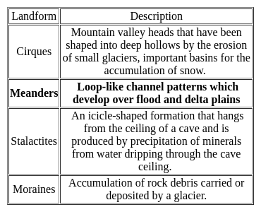
________ are loop-like channel patterns which develop over flood and delta plains.

Detailed Solution for Kerala SET Paper 2 Mock Test - 1 (Geography) - Question 1

The correct answer is 'Meanders'.

Key Points

Kerala SET Paper 2 Mock Test - 1 (Geography) - Question 2

The theory of plate tectonics proposes that the earth’s lithosphere is divided into ______ major and some minor plates.

Detailed Solution for Kerala SET Paper 2 Mock Test - 1 (Geography) - Question 2

The correct answer is 7.
Key Points

  • The theory of plate tectonics proposes that the earth's lithosphere is divided into 7 major and 8 minor plates.
  • The theory of plate tectonics is the modern update of Continental drift proposed by Alfred Wegener in 1912.
  • The theory of plate tectonics explains the features and movement of the Earth's surface.
  • In Plate tectonics, Earth’s outermost layer i.e. the lithosphere is broken into large rocky plates.
  • Plate tectonics explains many events such as volcanoes, earthquakes, and the formation of mountains which are a result of Earth’s subterranean movements.
  • The Lithosphere is made of the crust and upper mantle of the Earth and is 100km thick.

Additional Information

  • The Largest plates are the Antarctic, Eurasian, and North American plates.
  • Continental plates (up to 200km) are thicker than oceanic plates (50-100km).
  • The Seven major plates are:
  1. African,
  2. Antarctic,
  3. Eurasian,
  4. North American,
  5. South American,
  6. India-Australian, and
  7. The Pacific plates

​The Some of minor plates are:

  • Arabian,
  • Caribbean,
  • Nazca, and
  • Scotia plates.​

Kerala SET Paper 2 Mock Test - 1 (Geography) - Question 3

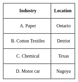
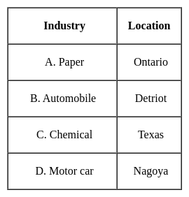
Consider the following pairs:

How many of the above mentioned pairs are correctly matched?

Detailed Solution for Kerala SET Paper 2 Mock Test - 1 (Geography) - Question 3

The correct answer is Only three.
Important Points

Here is the justification for each:

Mississippi:

  • The Mississippi River is one of the longest rivers in North America, flowing through ten U.S. states, from Minnesota to the Gulf of Mexico.

Amazon:

  • The Amazon River is in South America, primarily flowing through Brazil and Peru.
  • It's the second longest river in the world and has the largest drainage basin on the planet, not to mention its crucial role in the Amazon Rainforest's ecosystem.

Orange:

  • The Orange River, contrary to what's listed in the table, is not in Asia.
  • It's actually the longest river in South Africa and forms part of the border between South Africa and Namibia.

Darling:

  • The Darling River is the third longest river in Australia, running through New South Wales.
  • It is part of the Murray-Darling river system, which is the longest river system in Australia.
Kerala SET Paper 2 Mock Test - 1 (Geography) - Question 4

What kind of products were exported by Canada during the 19th century?

Detailed Solution for Kerala SET Paper 2 Mock Test - 1 (Geography) - Question 4

During the 19th century, Canada was a major exporter of primary products, mainly to the United Kingdom. The greatest single export item is forest products which accounts for a third of the annual total. After that comes wheat and flour and many important minerals.

Kerala SET Paper 2 Mock Test - 1 (Geography) - Question 5
Consider the following statements:-

a. GIS is an institutional entity, reflecting an organisational structure that integrates technology with a database, expertise and continuing financial support over time.

b. GIS is an internally referenced, automated, spatial information system.

c. GIS is any manual or computer-based set of procedures used to store and manipulate geographically referenced data.

d. GIS can present the results of information analyses using multimedia technologies

Which of the following statements above is /are correct?

Detailed Solution for Kerala SET Paper 2 Mock Test - 1 (Geography) - Question 5

All the above statements are correct, since GIS can be defined as a toolbox, as a database and as an organization. The first three statements explain GIS in terms of Database and Organization while the last statement is a characteristic feature of GIS. So, simply stated, GIS is a set of computer-based systems for managing geographical data and using these data to solve spatial problems.

Thus, the Correct answer is D.

Kerala SET Paper 2 Mock Test - 1 (Geography) - Question 6
Which one of the following is correct for the cost-input graph of industrial production system, where point of profit maximising output is
Detailed Solution for Kerala SET Paper 2 Mock Test - 1 (Geography) - Question 6
Key Points

Cost-input graph of industrial production system:

  • In a cast input graph of industrial production, profit is maximized at the point at which an additional increment to output leaves profit unchanged.
  • The point at which marginal revenue equals marginal cost maximizes a company's profit.
  • The marginal cost of production measures the change in total cost of a good that arises from producing one additional unit of that good.
  • The marginal revenue is calculated by dividing the change in the total revenue by the change in the quantity.
  • From those input quantities and the price of inputs, the firm can determine the Total Cost of producing any level of output.
  • Total cost (TC) is the price of the inputs multiplied by the quantity of the inputs.

Hence, Marginal cost equals marginal revenue is correct for the cost-input graph of the industrial production system, where the point of profit-maximizing output.

Kerala SET Paper 2 Mock Test - 1 (Geography) - Question 7
Consider the following statements about human environment interaction and state which amongst the following is true:

i. The type of society has strong influence over the environment .

ii. Human characteristics have impact on the environment.

iii. Education is a key factor on people’s view of life.

iv. Ecosystem services are important for human well-being.

Choose the correct option from below:

Detailed Solution for Kerala SET Paper 2 Mock Test - 1 (Geography) - Question 7

 Human environment interaction involves understanding of human characteristics. The type of society strongly influences people’s attitude towards nature, their behavior, and therefore their impact on ecosystem. Important characteristics of human social systems are population size, social organization, values, technologies etc.

Thus, the Correct answer is D.

Kerala SET Paper 2 Mock Test - 1 (Geography) - Question 8

Cirrus' refers to

Detailed Solution for Kerala SET Paper 2 Mock Test - 1 (Geography) - Question 8

'Cirrus' refers to a high cloud.

Important Points

Cirrus Cloud:-

  • Cirrus clouds appear high in the atmosphere, above 20,000 feet (6 km).
  • Cirrus clouds are made of tiny ice crystals.
  • The atmosphere is very cold in the stratosphere where cirrus clouds occur.
  • Cirrus clouds are high-level clouds found at an altitude of 20,000 feet or higher.
  • These clouds are composed of ice crystals and are usually thin, wispy, and white.

They are sometimes called "mare's tails" because of their long, thin, and feathery appearance. Cirrus clouds usually indicate fair weather, but they can also be a sign of an approaching storm.

Additional Information

  • Cumulus clouds:-
    • These clouds form when the air cools to the dew point, the temperature at which the air can no longer hold all its water vapor.
    • These “fair weather” clouds look like cotton wool.
    • If we look at a sky filled with cumuli, we may notice they have flat bases, which all lie at the same level.
    • So, Statement 2 is correct.
  • Stratus clouds:-
    • These are composed of thin layers of clouds covering a large area of the sky.
    • This is simply mist or fog when it forms close to the ground.
    • We can easily distinguish a stratus cloud by the long horizontal layers of the cloud which have a fog-like appearance
    • So, Statement 3 is correct.
  • Nimbus Clouds:-
    • The word nimbus means a cloud that already has rain or snow falling from it.
    • These clouds are dark and seen during a thunderstorm along with thunder and lightning.
Kerala SET Paper 2 Mock Test - 1 (Geography) - Question 9

Arrange the following continents in descending order of size:

South America, Africa, Antarctica, Europe, North America

Choose the correct option.

Detailed Solution for Kerala SET Paper 2 Mock Test - 1 (Geography) - Question 9

The correct answer is Africa, North America, South America, Europe, Antarctica
Important Points

Africa:

  • Africa is the largest continent in terms of land area. It spans across 30.37 million square kilometers and is home to 54 recognized countries.
  • Some of the notable features of Africa include the Sahara Desert, the Nile River, and diverse wildlife in regions like the Serengeti and the Congo Basin.

North America:

  • North America is the second-largest continent in terms of land area.
  • It covers approximately 24.71 million square kilometers and includes countries such as the United States, Canada, Mexico, and several others.
  • Notable geographical features of North America include the Rocky Mountains, the Great Lakes, and the Grand Canyon.

South America:

  • South America is the third-largest continent, slightly smaller than North America.
  • It spans about 17.84 million square kilometers and includes countries like Brazil, Argentina, Peru, and many more.
  • South America is known for the Amazon Rainforest, the Andes Mountains, and iconic landmarks like Machu Picchu.

Antarctica:

  • Antarctica is the fourth-largest continent and the smallest among the five. It is located in the southernmost part of the Earth and is predominantly covered by ice.
  • Antarctica has a land area of about 14.0 million square kilometers, but most of it is covered by a thick ice sheet.
  • It is uninhabited permanently, except for some research stations, and serves as a unique scientific research site.

Europe:

  • Europe is the fifth-largest continent in terms of land area. It covers around 10.18 million square kilometers and includes countries like Germany, France, Italy, and others.
  • Europe is renowned for its rich history, diverse cultures, and famous landmarks such as the Eiffel Tower, the Colosseum, and the Acropolis.
Kerala SET Paper 2 Mock Test - 1 (Geography) - Question 10
Which of these is not a type of federal state ?
Detailed Solution for Kerala SET Paper 2 Mock Test - 1 (Geography) - Question 10

Key Points

Federal state:

  • The federal government is a type of national government in which the government has powers to delegates the power to other elected members of the states.
  • There can be two levels of the federal government in a country either it is performing through common institutions or through powers as prescribed by a constitution of the state.
  • It is totally opposite to the unitary government.
  • In federation or federal government, provinces or territories enjoy some rights as are available to the independent states.
  • However international diplomacy, national security, foreign affairs, and other kinds of international dealings are solely made by the federal government.
  • In the federal system, power is jointly shared between the state and federal governments.
  • In the federal government system, the powers never rest with one national government.
  • However, there can be certain powers and authorities that remain totally with the federal government like policies on defence, budget, international diplomacy, etc.
  • Some of the examples are India, Pakistan, India, Brazil, Switzerland, Australia, Belgium, Canada, etc.
  • The three lists and their components are as follows,

  • It has a centralized form along with state and common responsibilities,

Therefore, Composite is not a type of federal state.

Kerala SET Paper 2 Mock Test - 1 (Geography) - Question 11
Till, Moraines and boulder clay are depositional land forms due to
Detailed Solution for Kerala SET Paper 2 Mock Test - 1 (Geography) - Question 11

The Correct Answer is Glacial activity.

  • Till Moraines and boulder clay are depositional landforms that are formed due to Glacial activities.

Key Points

  • ​Boulder clay:
    • Boulder clay is a geological deposit of clay.
    • It is often full of boulders, which are formed out of the ground moraine material of glaciers and ice sheets.
    • Boulder clay is classed with a group of poorly sorted materials, described by the non-genetic term diamicton.
    • It was a typical deposit found in the Glacial Period.
    • Found in northern Europe and North America.
  • Moraine:
    • A moraine is an accumulation of unconsolidated debris (regolith and rock).
    • It is sometimes referred to as glacial till.
    • It occurs in both currently and formerly glaciated regions, and also which has been previously carried along by a glacier or ice sheet.
    • It may consist of partly rounded particles ranging in size from boulders to gravel and sand.
      • Sometimes called glacial flour.
    • Lateral moraines are those formed at the side of the ice flow, and terminal moraines were formed at the foot, marking the maximum advance of the glacier.
    • Other types of moraines include ground moraines and medial moraines.

​​​

Kerala SET Paper 2 Mock Test - 1 (Geography) - Question 12
As per results from the research conducted by the Atomic Energy Commission of India, in 2011, which of the following mines is considered the largest reserve of uranium in India ?
Detailed Solution for Kerala SET Paper 2 Mock Test - 1 (Geography) - Question 12

The correct answer is Tummalapalle mine.

Key Points

  • The Tummalapalle Mine is a uranium mine found in Tumalapalli hamlet in Kadapa, Andhra Pradesh, India.
  • The results of studies undertaken by India's Atomic Energy Commission in 2011 led analysts to believe that this mine may hold one of the world's greatest uranium reserves.
  • On July 19, 2011, Dr. S. Banerjee, Secretary of the Department of Atomic Energy and Chairman of the Atomic Energy Commission of India, confirmed 49,000 tonnes of uranium reserves and speculated that there could be three times that amount, making Tummalapalle the world's largest uranium mine.

Important Points

  • The Jaduguda Mine is a uranium mine located in Jaduguda village, Purbi Singhbhum district, Jharkhand, India.
  • Since April 1995, the Narwapahar Mine has been the first completely mechanized mine in operation.
  • The Bhatin Mine is a tiny underground mine 3 kilometers from Jaduguda. It uses Jaduguda Mine's infrastructure for the most part.
Kerala SET Paper 2 Mock Test - 1 (Geography) - Question 13

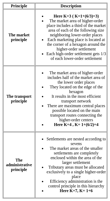
Given below are two statements, one is labelled as Assertion (A) and the other is labelled as Reason (R). Read the statements and choose the correct answer using the code given below.

Assertion (A) : Central Business District (CBD) of a city has high concentration of wholesale stores, offices and cultural and recreational activities.

Reason (R) : Prices and demand of real increases as distance towards CBD reduces.

Detailed Solution for Kerala SET Paper 2 Mock Test - 1 (Geography) - Question 13
Key Points

Assertion (A): Central Business District (CBD) of a city has a high concentration of wholesale stores, offices, and cultural and recreational activities.

The concept of CBD:

  • The term Central Business District (CBD) is a widely used term in commercial real estate and is defined as the functional area of a city that has the maximum concentration of commercial, retail, and business centers.
  • Geographically, it coincides with the city center and is the focal point for the transportation networks of the city.
  • It has maximum urban density than other districts of the town and offers a healthy environment for carrying out various commercial activities.
  • Today, CBDs are a diverse region in metro cities that not only include retail spaces, commercial, offices, financial institutions, government centres, and medical centres, but also entertainment hubs, restaurants, hotels, and residential area

Hence, the assertion is correct.

Reason (R): Prices and demand of real increases as distance towards CBD reduces.

Price and demand relationship:

  • In ancient times, CBDs were the market squares where merchants and customers gathered to sell and buy things.
  • However, as cities evolved, land scarcity and increasing demand reduced horizontal expansions and gave way to vertical developments.
  • The relationship of land price and distance to CBD is significant and negative, which means indicating the decreasing of land price by increasing distance from the CBD.
  • Market price gives the same result as the appraised price which is the effect of distance on land values is significant and negative.

Hence, the reason is also correct.

Therefore, Both (A) and (R) are true and (R) is the correct explanation of (A).

Kerala SET Paper 2 Mock Test - 1 (Geography) - Question 14
Consider the following statements about Losch’s theory of industrial location and choose which amongst them is true:

i. Goods have high demand with low prices.

ii. The demand curve rotated round the production point to give shape.

iii. As the competition increases, the market areas becomes hexagonal.

Detailed Solution for Kerala SET Paper 2 Mock Test - 1 (Geography) - Question 14

Losch’s theory attempts to explain the size and shape of market area within which a location would command the largest revenue. It is assumed that the demand varies inversely with price. This gives us a demand pattern. The demand curve can be rotated round the production point to give the size and shape of the market space. With increasing competition, the size of the market area becomes hexagonal. They also become smaller as the markets are competed away.

Thus, the Correct answer is D.

Kerala SET Paper 2 Mock Test - 1 (Geography) - Question 15
Consider the following statements:-

a) The Geographical Pivot of History was written by Sir Halford Mackinder in the year 1904

b) According to Spykman, aerial mobility is the new type of geopolitical structure.

Which of the following options are correct?

Detailed Solution for Kerala SET Paper 2 Mock Test - 1 (Geography) - Question 15

Mackinder presented his model, ' The Geographical Pivot of History' in front of the Royal Geographical Society in London in 1904. This model was developed during a period when Britain was losing her political and economic significance to the world economy.

Maritime mobility, according to Spykman, was the fundamental fact that was responsible for the development of the world politics. The development of ocean navigation and sea routes to various parts of the world has led a new structure of great power and enormous extent.

Kerala SET Paper 2 Mock Test - 1 (Geography) - Question 16
India is the leading producer of which of the following crop?
Detailed Solution for Kerala SET Paper 2 Mock Test - 1 (Geography) - Question 16

 India ranks second in production of rice and wheat in world, after China. India holds third rank in world production of cotton. India has the largest area under Sesamum cultivation in world and is also the largest producer of the same, making for nearly one-third of the total produce of the oilseed in world.

Thus, the correct answer is C.

Kerala SET Paper 2 Mock Test - 1 (Geography) - Question 17
The upper portion of the mantle is called .
Detailed Solution for Kerala SET Paper 2 Mock Test - 1 (Geography) - Question 17

The correct answer is asthenosphere.

Key Points

  • Asthenosphere:
    • The asthenosphere is the denser, weaker layer beneath the lithospheric mantle.
    • It lies between about 100 kilometers (62 miles) and 410 kilometers (255 miles) beneath Earth's surface.
    • The temperature and pressure of the asthenosphere are so high that rocks soften and partly melt, becoming semi-molten.
    • The asthenosphere is generally more viscous than the lithosphere, and the lithosphere-asthenosphere boundary (LAB) is the point where geologists and rheologists, scientists who study the flow of matter mark the difference in ductility between the two layers of the upper mantle.

So, it is clear that the asthenosphere is located beneath the crust and the crustal plates are moving over this layer.

Additional Information
  • Lithosphere
  • ​The crust and the uppermost part of the mantle are called the lithosphere.
    • Its thickness ranges from 10-200 km.
    • The lithosphere is the solid, outer part of the Earth.
    • The lithosphere includes the brittle upper portion of the mantle and the crust, the outermost layers of Earth’s structure.
    • It is bounded by the atmosphere above and the asthenosphere (another part of the upper mantle) below.
  • Stratosphere:
    • It is the second major strata of air in the atmosphere.
    • It is found above the tropopause and extends up to a height of 50 km.
    • One important feature of the stratosphere is that it contains the ozone layer.
    • This layer absorbs ultra-violet radiation and shields life on the earth from an intense, harmful form of energy.
    • The air temperature in the stratosphere remains relatively constant up to an altitude of 15 miles (25 km).
  • Mesosphere:
    • The mesosphere is a layer of Earth's atmosphere.
    • The mesosphere is directly above the stratosphere and below the thermosphere.
    • It extends from about 50 to 85 km (31 to 53 miles) above our planet.
    • Temperature decreases with height throughout the mesosphere.
Kerala SET Paper 2 Mock Test - 1 (Geography) - Question 18

Which of the following is true about Tropical Rain forest?

(A) These forest are called evergreen forests.

(B) The trees in these forests shed their leaves at different times of the year.

(C) Sal, Teak and Shisham are important trees of these forests.

(D) These forests are called monsoon forests.

Choose the correct option

Detailed Solution for Kerala SET Paper 2 Mock Test - 1 (Geography) - Question 18

The correct answer for the given question is option 1, which includes options (A) and (B).

Key Points

  • Tropical rainforests are called evergreen forests because they have high annual rainfall and consistent temperature, which allows the trees to retain their leaves throughout the year.
  • The trees in tropical rainforests do not shed their leaves at the same time, but rather at different times of the year, which is known as deciduousness.
  • Sal, Teak, and Shisham are not important trees in tropical rainforests. These trees are commonly found in dry deciduous forests and savannas.
  • Tropical rainforests are not called monsoon forests. Monsoon forests are a type of tropical seasonal forest that experiences a distinct wet and dry season.

Additional Information

Additional information about the other options mentioned in the question are: - Option 2, which includes options (A) and (C), is incorrect because Sal, Teak, and Shisham are not important trees in tropical rainforests. - Option 3, which includes options (B) and (D), is incorrect because tropical rainforests are not called monsoon forests. - Option 4, which includes options (C) and (D), is incorrect because Sal, Teak, and Shisham are not important trees in tropical rainforests and tropical rainforests are not called monsoon forests. Key points for the correct options are: - Tropical rainforests are called evergreen forests because they have high annual rainfall and consistent temperature. - The trees in tropical rainforests do not shed their leaves at the same time, but rather at different times of the year. - Tropical rainforests are characterized by high biodiversity and complex ecosystems. - Tropical rainforests are vital for regulating the global climate and providing ecosystem services such as carbon storage, water cycling, and habitat for wildlife.

Kerala SET Paper 2 Mock Test - 1 (Geography) - Question 19
Michel Thomas Sadler has propounded the concept of
Detailed Solution for Kerala SET Paper 2 Mock Test - 1 (Geography) - Question 19

Michel Thomas Sadler has propounded the concept of Destiny and Fecundity Principal.

  • Sadler was born in 1780 and he passed away in 1835
  • Sadler was a British economist and social reformer
  • He was a contemporary of Malthus
  • His idea was expressed in detail in his book ‘The Law of population’

Important Points

‘The fecundity of human beings is in the inverse ratio of the condensation of their numbers.’

  • The fertility rate decreases with the increasing density of the population.
  • In agriculture-based economies/ pastoral countries, people are more hard-working and have the capacity to give birth to more children.
  • In industrialized countries, people are more civilized and literate. People would limit the size of the family.
  • The density is comparatively high.
  • Population adjusts itself. If the death rate increases, the birth rate also increases to compensate the population and vice versa.

Additional Information

  • Theory of Land Rent: David Ricardo
  • Zone and Strata Theory: G. Taylor
  • An Essay on the Principle of Population: Thomas Robert Malthus
Kerala SET Paper 2 Mock Test - 1 (Geography) - Question 20

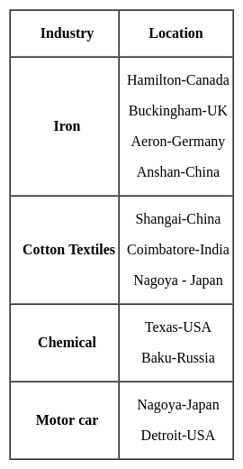
Which one of the following pairs is not correctly matched?

Detailed Solution for Kerala SET Paper 2 Mock Test - 1 (Geography) - Question 20

The correct answer is B.
Key Points

  • The correct order is as follows -

Important Points

  • Other important industrial centers of the world are:-
Kerala SET Paper 2 Mock Test - 1 (Geography) - Question 21

Consider the following statements regarding the Remote Sensing Survey:

1) Information transfer is accomplished by the use of electromagnetic radiation

2) Remote Sensing from space is done by satellites

3) Remote Sensing has no application in Earthquake prediction

Which of the above statements are correct?

Detailed Solution for Kerala SET Paper 2 Mock Test - 1 (Geography) - Question 21

Remote sensing survey:

It is the art and science of obtaining information about an object or feature without physically coming in contact with that object.

Characteristics of remote sensing

  1. The data collected using it is in various forms such as variations in acoustic wave distributions (SONAR), variations in force distributions (gravity meter), variations in electromagnetic energy distributions.
  2. The remote sensing is the process of inferring surface parameters from measurements of the electromagnetic radiation (EMR) from the Earth’s surface.
  3. In space-borne remote sensing, sensors are mounted on a satellite orbiting the earth.

Advantages of remote sensing are:

  1. The current situation of remote sensing application for earthquake research indicates a few phenomena, related with earthquakes, particularly the Earth's surface deformation, surface temperature and humidity, atmosphere temperature and humidity, gas and aerosol content. Both horizontal and vertical deformations scaled from tens of centimeters to meters are recorded after the shock
  2. Remote sensing provides data on large areas.
  3. It can be used to obtain data of very remote and inaccessible regions.
  4. It is relatively cheap when compared to employing a team of surveyors.
  5. Easy and rapid collection of data.
  6. Rapid production of maps for interpretation.
Kerala SET Paper 2 Mock Test - 1 (Geography) - Question 22
Which one of the following economic principles is correct for organisation of settlements based on K = 4 presented in the Christaller's central place model?
Detailed Solution for Kerala SET Paper 2 Mock Test - 1 (Geography) - Question 22

Central Place Theory:

  • The theory was postulated by Walther Christaller
  • It was published in his book “Central Place in Southern Germany” (Die zentralen Orte in Suddeutschland) in 1933 and translated in English in 1966.
  • It is a normative theory
  • Based on the data obtained from Bavaria in South Germany
  • No of settlements are represented by ‘K’

Key Points

Principles of Central Place Theory:

Hence, transport principles are correct for the organization of settlements based on K = 4 presented in Christaller's central place model.

Kerala SET Paper 2 Mock Test - 1 (Geography) - Question 23

A medical geographer researching the spatial distribution of asthma among children 12–17 years of age in a major U.S. city hypothesizes that there is a link between poverty and the prevalence of the disease. Which of the following research strategies would best enable the geographer to explore that hypothesis?

Detailed Solution for Kerala SET Paper 2 Mock Test - 1 (Geography) - Question 23

This question requires the examinee to demonstrate knowledge of sources of geographic information, characteristics and uses of geographic systems, and geographic tools and technologies. Geographic information systems, which digitally create spatial areas, use sophisticated software to organize, manipulate, and analyze diverse forms of geographic data. Such a system would be a particularly effective means of correlating places of asthma occurrence with the socioeconomic characteristics of those places to determine whether there is a link between poverty and the prevalence of the disease.

Kerala SET Paper 2 Mock Test - 1 (Geography) - Question 24

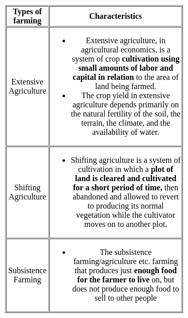
A type of farming in which higher doses of modern inputs are used to obtain higher productivity is known as

Detailed Solution for Kerala SET Paper 2 Mock Test - 1 (Geography) - Question 24

Farming varies from subsistence to commercial type. The cultivation methods have changed significantly depending upon the characteristics of the physical environment, technological know-how, and socio-cultural practices.

Commercial Farming:

  • The main characteristic of this type of farming is the use of higher doses of modern inputs
  • For example, high yielding variety (HYV) seeds, chemical fertilizers, insecticides, and pesticides in order to obtain higher productivity.
  • The degree of commercialization of agriculture varies from one region to another.
  • For example, rice is a commercial crop in Haryana and Punjab, but in Odisha, it is a subsistence crop.
  • The plantation is also a type of commercial farming. In this type of farming, a single crop is grown in a large area.
  • The plantation has an interface of agriculture and industry.
  • Plantations cover large tracts of land, using capital-intensive inputs, with the help of migrant laborers.
  • All the produce is used as raw material in respective industries.
  • In India, tea, coffee, rubber, sugarcane, banana, etc.. are important plantation crops.
  • Tea in Assam and North Bengal coffee in Karnataka are some of the important plantation crops grown in these states.

Hence, the type of farming in which higher doses of modern inputs are used to obtain higher productivity is known as Commercial Farming.
Additional Information

Kerala SET Paper 2 Mock Test - 1 (Geography) - Question 25
Read the following statements and select the correct answer from the code given below:

(a) The satellite towns are a part of the main city’s municipal corporation.

(b) The satellite towns develop beyond city’s green belt.

(c) The satellite towns are totally dependent upon the main city area.

(d) The satellite towns are separated from the main city physically by a geographical barrier like river.

Code:

Detailed Solution for Kerala SET Paper 2 Mock Test - 1 (Geography) - Question 25

The Satellite towns have a working administrative body of their own, generally municipalities. These towns have at least partial social and economic independence, but commute to city for is common. These areas develop beyond city’s green belt and have a geographical barrier like river which separated the satellite town as a separate, but somewhat dependent entity from the main city.

Thus, the correct answer is C.

Kerala SET Paper 2 Mock Test - 1 (Geography) - Question 26
Ghost towns are:
Detailed Solution for Kerala SET Paper 2 Mock Test - 1 (Geography) - Question 26

The correct answer is Deserted towns.
Important Points

Ghost towns:

  • Ghost towns are towns or settlements that were once inhabited but have since been abandoned or deserted.
  • They are usually associated with a decline in economic activity or a change in the local environment that made it difficult or impossible for people to continue living there.
  • Ghost towns can be found all over the world, and they can be the result of various factors such as changes in industry, natural disasters, wars, or simply the passage of time. Some ghost towns may have once flourished and been bustling centers of activity, but they have since been deserted and left to decay.
  • While natural calamities such as earthquakes, floods, or hurricanes can contribute to the abandonment of a town, they are not the defining characteristic of a ghost town. Rather, it is the fact that the town has been deserted or left to decay that makes it a ghost town.
  • In summary, ghost towns are deserted towns or settlements that were once inhabited but have since been abandoned or left to decay, usually as a result of changes in the local environment or economic activity.

Additional Information

  • Bodie was a mining town that was established in 1859 during the California Gold Rush. At its peak, Bodie had a population of around 10,000 people and was a bustling center of activity, with numerous saloons, hotels, and stores.
  • However, by the early 20th century, the mines in Bodie had been depleted, and the town began to decline. By the 1940s, the town was virtually abandoned, and today it is preserved as a state historic park.
  • Visitors to Bodie can see many of the town's original buildings and artifacts, which have been preserved in a state of "arrested decay."
  • The town's streets are lined with abandoned buildings, including a church, a schoolhouse, and numerous homes and businesses. Visitors can take guided tours of the town and learn about the lives of the people who once lived there.
  • Bodie is a classic example of a ghost town, as it was once a thriving community that was eventually abandoned due to changes in the local economy. Today, it serves as a fascinating and eerie reminder of the boom-and-bust cycle that characterized many mining towns in the American West.
Kerala SET Paper 2 Mock Test - 1 (Geography) - Question 27
Which of the human made resource have huge economic importance?
Detailed Solution for Kerala SET Paper 2 Mock Test - 1 (Geography) - Question 27

Key PointsHuman Made Resources:

  • Human-made resources, also known as capital resources, are material riches created by humans that can be used to create more wealth.
  • Examples include money, factories, roads, and technology.
  • Man-made resources are important because they can be conserved for the future and are produced by using skill, knowledge, and technology at their best.
  • Man-made resources are the signs of progress and development and are the refined form of natural resources.

Technological resources are the backbone of engineering and technology. It is a kind of human-made resource that has huge economic importance in innovation and development procedures. Educational quality, skill, and efficiency are human resources, not human-made resources.

Additional Information

Human Resources:

  • Human Resource refers to the number (quantity) and abilities (mental and physical) of people.
  • Though there are differing views regarding the treatment of humans as a resource, one cannot deny the fact that it is the skills of humans that help in transferring the physical material into a valuable resource.
  • The term human resources refer to the size of the population of a country along with its efficiency, educational qualities, productivity, organizational abilities, and farsightedness.
  • It is the ultimate resource, but not equally, distributed over the world.
Kerala SET Paper 2 Mock Test - 1 (Geography) - Question 28
What is the median of the values 11, 7, 6, 9, 12, 15, 19 ?
Detailed Solution for Kerala SET Paper 2 Mock Test - 1 (Geography) - Question 28

Calculation:

Data in ascending order = 6, 7, 9, 11, 12, 15, 19

Since, n = 7 (odd)

Hence,

Median =

= 4th term = 11

∴ The median of the values is 11.

Kerala SET Paper 2 Mock Test - 1 (Geography) - Question 29

A potential downside of medical tourism can be:

Detailed Solution for Kerala SET Paper 2 Mock Test - 1 (Geography) - Question 29

​Access to post-operative care and follow-up appointments after returning home

While medical tourism provides numerous advantages such as cost savings, access to specialized treatments, and reduced waiting times, it also comes with its set of challenges and potential downsides. These downsides can affect the quality of care and the overall patient experience, making it essential for individuals considering medical tourism to weigh these factors carefully.

Key Points

1. Access to post-operative care and follow-up appointments after returning home:

  • This option highlights a significant downside of medical tourism.
  • After undergoing medical procedures abroad, patients might face challenges in accessing necessary post-operative care and follow-up appointments upon returning to their home country.
  • Coordination between the healthcare provider abroad and local healthcare providers can be complex, leading to potential gaps in care.
  • Additionally, complications or questions that arise post-surgery might be harder to address without direct access to the medical team that performed the procedure.
  • This can impact the overall success of the treatment and patient recovery.

Additional Information

2. Lack of familiarity with cultural norms and language barriers at the destination:

  • While navigating cultural norms and language barriers can be challenging for medical tourists, this factor is not inherently a downside of medical tourism itself but rather a consideration that individuals must prepare for when choosing a destination.
  • Many medical tourism providers offer translation services and cultural orientation to minimize these issues.

3. Increased economic benefits for the hosting country:

  • This option describes a positive outcome of medical tourism rather than a downside.
  • Medical tourism can significantly contribute to the economy of the hosting country by generating revenue, creating jobs, and stimulating local development.
  • This aspect is beneficial for the destination country and does not represent a disadvantage for medical tourists.

4. Improved access to preventative healthcare in developing nations:

  • This option also outlines a positive impact of medical tourism, particularly for the hosting countries.
  • The influx of medical tourists can lead to improvements in healthcare infrastructure and services, including preventative care, benefiting both tourists and the local population.
  • This is not a downside for individuals seeking medical treatment abroad.

Important Points

  • Potential patients contemplating medical tourism should conduct thorough research and planning, including understanding the risks and challenges associated with post-operative care and follow-up.
  • Establishing a plan with healthcare providers both at home and abroad for ongoing care, and considering the purchase of medical tourism insurance, can help mitigate some of these downsides.
Kerala SET Paper 2 Mock Test - 1 (Geography) - Question 30

Which one of the following is the junction point of the Eastern Ghats and Western Ghats?

Detailed Solution for Kerala SET Paper 2 Mock Test - 1 (Geography) - Question 30

Nilgiri Hills is the junction point of the Eastern Ghats and Western Ghats. The Eastern Ghats are a discontinuous range of mountains along India's eastern coast whereas Western Ghats also known as Sahyadri is a mountain range that runs parallel to the western coast of the Indian peninsula. Eastern ghats and Western ghats meet at the Nilgiri hills in Tamilnadu.

View more questions
30 tests
Information about Kerala SET Paper 2 Mock Test - 1 (Geography) Page
In this test you can find the Exam questions for Kerala SET Paper 2 Mock Test - 1 (Geography) solved & explained in the simplest way possible. Besides giving Questions and answers for Kerala SET Paper 2 Mock Test - 1 (Geography), EduRev gives you an ample number of Online tests for practice
Download as PDF