SSC CGL Exam  >  SSC CGL Tests  >  SSC CGL Tier 2 - Study Material, Online Tests, Previous Year  >  Map Based Test - 5 - SSC CGL MCQ

Map Based Test - 5 - SSC CGL MCQ


Test Description

30 Questions MCQ Test SSC CGL Tier 2 - Study Material, Online Tests, Previous Year - Map Based Test - 5

Map Based Test - 5 for SSC CGL 2024 is part of SSC CGL Tier 2 - Study Material, Online Tests, Previous Year preparation. The Map Based Test - 5 questions and answers have been prepared according to the SSC CGL exam syllabus.The Map Based Test - 5 MCQs are made for SSC CGL 2024 Exam. Find important definitions, questions, notes, meanings, examples, exercises, MCQs and online tests for Map Based Test - 5 below.
Solutions of Map Based Test - 5 questions in English are available as part of our SSC CGL Tier 2 - Study Material, Online Tests, Previous Year for SSC CGL & Map Based Test - 5 solutions in Hindi for SSC CGL Tier 2 - Study Material, Online Tests, Previous Year course. Download more important topics, notes, lectures and mock test series for SSC CGL Exam by signing up for free. Attempt Map Based Test - 5 | 30 questions in 35 minutes | Mock test for SSC CGL preparation | Free important questions MCQ to study SSC CGL Tier 2 - Study Material, Online Tests, Previous Year for SSC CGL Exam | Download free PDF with solutions
Map Based Test - 5 - Question 1

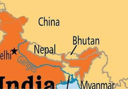
The country of Bhutan is surrounded by

Detailed Solution for Map Based Test - 5 - Question 1
It is landlocked between Tibet Autonomous Region - north and Indian states of Sikkim, WB, Assam and Arunachal Pradesh.

Map Based Test - 5 - Question 2

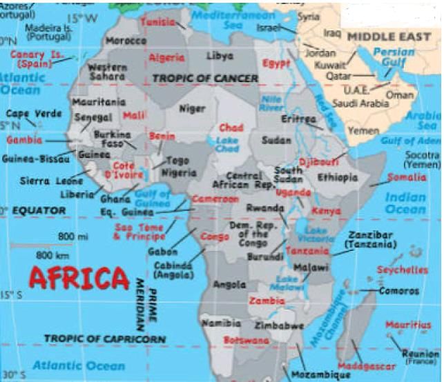
The continent having the largest area in the equatorial belt is

Detailed Solution for Map Based Test - 5 - Question 2

The continent that has occupied the largest area in the equatorial belt is Africa.

1 Crore+ students have signed up on EduRev. Have you? Download the App
Map Based Test - 5 - Question 3

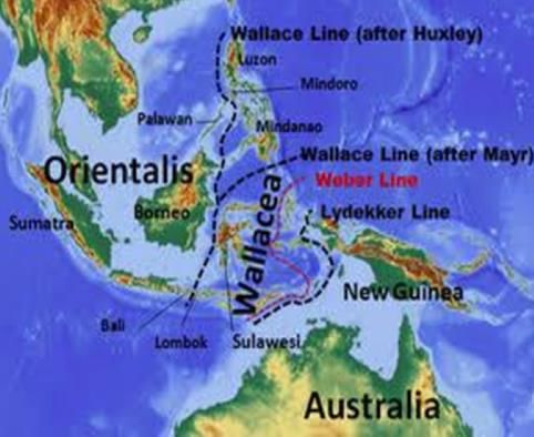
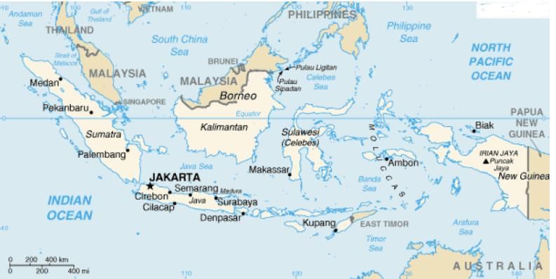
The Wallace's line separates the flora and fauna between

Detailed Solution for Map Based Test - 5 - Question 3
The Wallace line is a faunal boundary line drawn in 1859 by British naturalist Alfred Russel Wallace and named by Thomas Henry Huxley, that separates the ecozones of Asia and Wallacea, a transitional zone between Asia and Australia.

Map Based Test - 5 - Question 4

Find the correct pair from the following pairs.

Detailed Solution for Map Based Test - 5 - Question 4

Palm Islands - Dubai

Sagarmatha- Eastern Nepal

South Atlantic - Island of Saint Helena


Map Based Test - 5 - Question 5

Which country in Asia continent is known as 'Land of Golden Fibre'?

Detailed Solution for Map Based Test - 5 - Question 5
Bangladesh is one of the largest jute producing countries in the world. Jute is called the Golden Fibre of Bangladesh.

Map Based Test - 5 - Question 6

The endangered olive Ridley turtles have the world's largest aggregation at

Detailed Solution for Map Based Test - 5 - Question 6
These are the smallest and most abundant of all sea turtles found in the world Inhabiting warm waters of the Pacific, Atlantic and Indian oceans.

Map Based Test - 5 - Question 7

Which lake, currently under dispute between India and China is in process of being Identified under the Ramsar Convention as a wetland of international importance?

Detailed Solution for Map Based Test - 5 - Question 7
It is situated in India and China.

The lake is in the process of being identified under Ramsar Convention as a wetland site of international importance. This will be the first trans boundary wetland in south Asia under the convention.

Map Based Test - 5 - Question 8

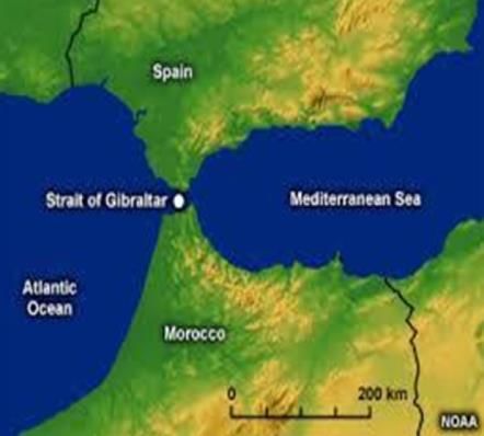
Which among the following straits connects the Mediterranean Sea with the Atlantic Ocean?

Detailed Solution for Map Based Test - 5 - Question 8
It is a narrow strait that connects the Atlantic Ocean and Mediterranean Sea, & separates Gibraltar and Peninsular Spain in Europe from Morocco and Ceuta (Spain) in Africa.

Map Based Test - 5 - Question 9

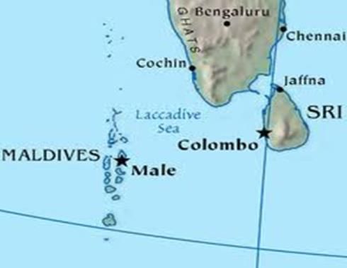
Which among the following is the coastal water body that lies off the Southwest coast of India, north of a line extending from the Southern point of Srijanka to the southernmost of the Maldives Islands and east of the Maldives?

Detailed Solution for Map Based Test - 5 - Question 9

Map Based Test - 5 - Question 10

Alph River and Onyx river are located in the following continents.

Detailed Solution for Map Based Test - 5 - Question 10

MOUNTAINS AND RIVERS

1. Dome A

2. Peak 3938

3. Dome F

4. Adams streams

5. Aiken Creek

6. Alph river

7. Lawson creek

8. Onyx river

Map Based Test - 5 - Question 11

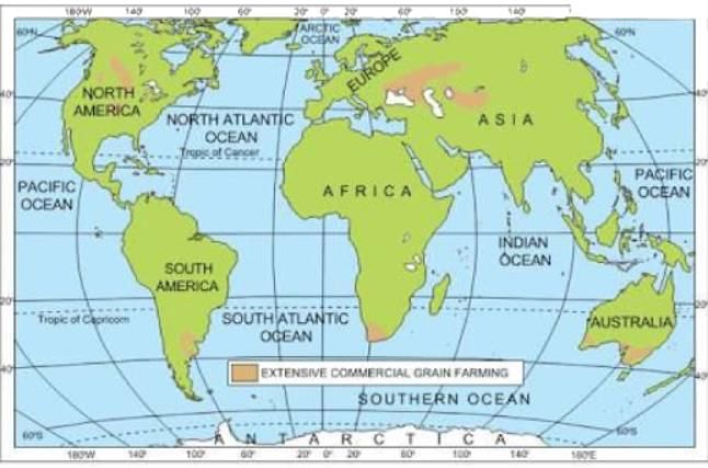
Consider the following factors about commercial grain farming.

1. Highly mechanised cultivation.

2. Large size of farms.

3. Predominance of wheat.

4. Excessive use of labour.

Q. Which of the statements given above are correct?

Detailed Solution for Map Based Test - 5 - Question 11
It's a type of agriculture that is largely dependent on mechanization. Wheat & maize are common commercially grown grains. It is mostly practiced in the temperate grasslands of North America, Europe and Asia.

Map Based Test - 5 - Question 12

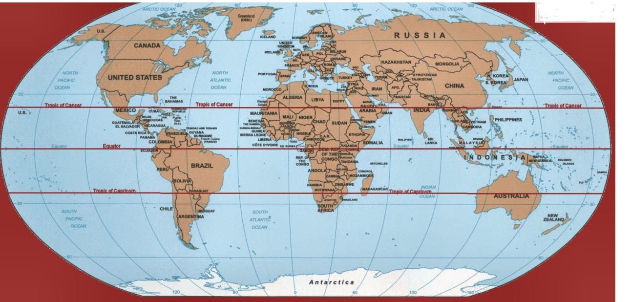
Africa is a hot continent because

Detailed Solution for Map Based Test - 5 - Question 12
Africa mainly lies within the intertropical zone between the Tropic of Cancer and the Tropic of Capricorn.

Only the northernmost and the southernmost fringes of the continent have a Mediterranean climate.

Because of this geographical situation, Africa is a hot continent as the solar radiation intensity is always high.

Map Based Test - 5 - Question 13

The Tropic of Capricorn passes through which of the following countries?

Detailed Solution for Map Based Test - 5 - Question 13
It's a line which runs parallel to the equator, but 26-degree 30" south of it.

The line passes through Chile, Argentina, Paraguay, Brazil, Namibia, Botswana, South Africa, Mozambique, Madagascar, Australia and French Polynesia, Clipping New Caledonia , Fiji, Tonga and the Cook Islands before landfall at Pitcairn .

The tropics experience little difference between seasons s o, between the Tropic of Capricorn and Tropic of Cancer (which is an equal distance north of the equator), life is generally warm and sunny.

Map Based Test - 5 - Question 14

Both Japan and Indonesia are made up of a chain of Islands called

Detailed Solution for Map Based Test - 5 - Question 14
An archipelago sometimes called an island group or island chain ,is a chain , cluster or collection of Islands or sometimes a sea containing a small number of scattered islands.

Indonesia, Japan, Taiwan, the Philippines, New Zealand, Maldives, the Bahamas, Greece , Hawaii, the Polynesian islands and Azores are the well known archipelagos.

The largest archipelagic state in the world by area and population is Indonesia.

Map Based Test - 5 - Question 15

Consider the following about tribal groups of Africa.

1. Swahili

2. Inca

3. Negro

4. Han

Q. Which of the above is/are found in Africa?

Detailed Solution for Map Based Test - 5 - Question 15

a) The Swahili people (or Waswahili) are a Bantu ethnic group inhabiting East Africa. Members of this ethnicity primarily reside on the Swahili coast, in an area encompassing the Zanzibar archipelago, littoral Kenya, the Tanzania seaboard, and northern Mozambique.

c) "Negro" was also used of the peoples of West Africa in old maps labelled Negroland, an area stretching along the Niger River. From the 18th century to the late 1960s, negro (later capitalized) was considered to be the proper English-language term for people of black African origin.

Map Based Test - 5 - Question 16

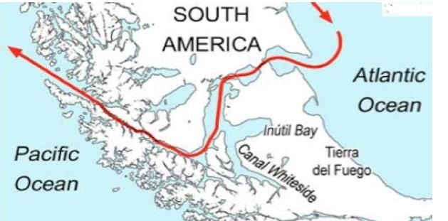
Which strait separates the mainland tip of America from the Tierra del Fuego Island and also connects Pacific with the Atlantic Ocean?

Detailed Solution for Map Based Test - 5 - Question 16
It's a navigable sea route separating mainland S. America to the north and Tierra del Fuego to the south. It is the most important natural passage between the Atlantic and Pacific Ocean.

Map Based Test - 5 - Question 17

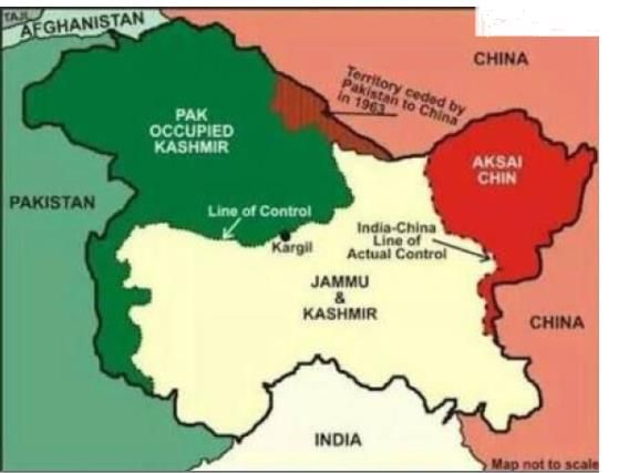
LAC, LOC and MacMahon (Sino-indian border) passes through which of the following states.

1. Jammu & Kashmir

2. Uttarakhand

3. Himachal Pradesh

4. Sikkim

5. Arunachal Pradesh

Detailed Solution for Map Based Test - 5 - Question 17

It is a demarcation line that The entire Sino-Indian border (including the western LAC, the small undisputed section in the centre, and the McMahon Line in the east) is 4,056 km (2,520 mi) long and traverses five Indian states/territories: Ladakh, Uttarakhand, Himachal Pradesh, Sikkim, and Arunachal Pradesh.separates Indian-controlled territory from Chinese controlled territory.

The entire Sino-indian border (including western LAC, small undisputed section section in centre and McMahon Line in east) traverses through 5 Indian states J & K, Uttarakhand , Himachal Pradesh, Sikkim and Arunachal Pradesh

Map Based Test - 5 - Question 18

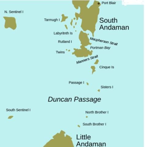
Duncan passage is situated between

Detailed Solution for Map Based Test - 5 - Question 18
It is a strait in the Indian Ocean that separates Rutland island (part of great Andaman)-north and Little Andaman-south.

West of Duncan passage is the Bay of Bengal and East is the Arabian Sea.

Small Islands & Islets lie along the passage are North Cinque Island, South Cinque Island, Passage island, The Sisters, North Brother island & South Brother Island.

Map Based Test - 5 - Question 19

In which one of the following places is the Shompen tribe found?

Detailed Solution for Map Based Test - 5 - Question 19
They are the indigenous people of the interior of Great Nicobar island, part of the Indian union territory of Andaman and Nicobar Islands. It is one of the least known particularly vulnerable tribal groups in the A & N islands.

Map Based Test - 5 - Question 20

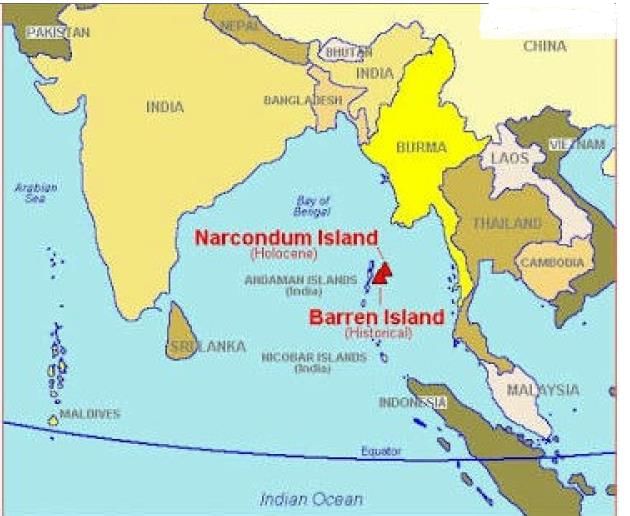
In which of the following Islands of India is an active Volcano found?

Detailed Solution for Map Based Test - 5 - Question 20
Barren island, one of the most easterly of Andaman Islands, is the only confirmed active volcano in India.

Map Based Test - 5 - Question 21

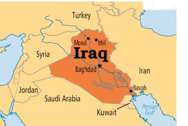
Which of the following are the borders shared by Iraq?

Detailed Solution for Map Based Test - 5 - Question 21
 

Map Based Test - 5 - Question 22

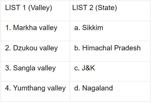
Match the following:

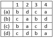
Codes:

Detailed Solution for Map Based Test - 5 - Question 22

Map Based Test - 5 - Question 23

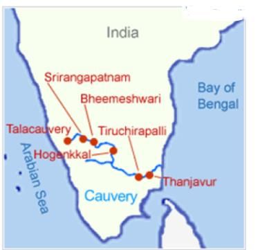
Which one of the following statements is not correct?

Detailed Solution for Map Based Test - 5 - Question 23
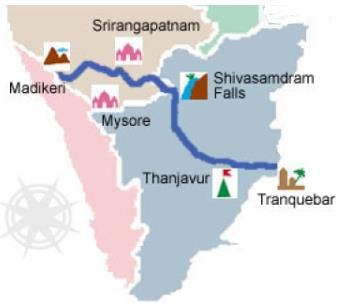
Cauvery river rises in Talacauvery, Karnataka.

Map Based Test - 5 - Question 24

Where is the Palghat pass present?

Detailed Solution for Map Based Test - 5 - Question 24

Located between the Nilgiri Hills to the north and Anaimalai Hills to the south, it is about 20 miles (32 km) wide and straddles the Kerala–Tamil Nadu border, serving as a major communication route between those two states. Highways and rail lines through the gap connect Palghat in Kerala with Coimbatore and Pollachi in Tamil Nadu.

Map Based Test - 5 - Question 25

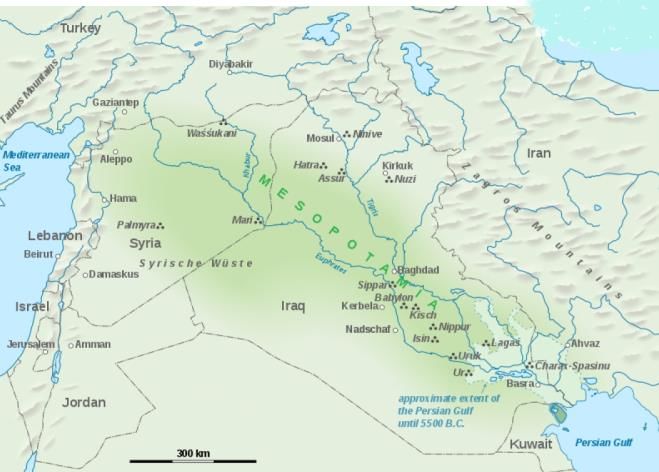
The region between the rivers Tigris and Euphrates historically called as___?

Detailed Solution for Map Based Test - 5 - Question 25
It's a historic region situated within the tigris-Euphrates river system, in modern days roughly corresponding to most of Iraq plus Kuwait, Syria, Turkey.

Map Based Test - 5 - Question 26

Consider the following facts about Odisha Longest bridge .

1. It is named after "Netaji Subhas Chandra Bose Setu".

2. It is built upon a river which is tributary of river Mahanadi.

3. It is the first 3 lane bridge on Bridge in Odisha and reduces the distance between cuttack and khordha.

Which of the following statements is/are correct?

Detailed Solution for Map Based Test - 5 - Question 26
  • Netaji Subhas Chandra Bose Setu (also called Netaji Setu) is the longest bridge over the river Kathajodi, a tributary of river Mahanadi.

  • It is the first 3 lane bridge in Odisha and reduces the distance between Bubaneswar and Cuttack.

  • It connects Belleview point near Judicial Academy in Cuttack to Trishulia.

Map Based Test - 5 - Question 27

Which of the following Museums have been matched correctly?

1. Chhatrapati Shivaji Vastu Museum - Mumbai

2. Shankar's International Dolls Museum - Delhi

3. Salar Jung Museum - Tamil Nadu

4. Calico Museum - Allahabad

Detailed Solution for Map Based Test - 5 - Question 27
 

1. Chhatrapati Shivaji Vastu Museum - Mumbai

2. Shankar's International Dolls Museum - Delhi

3. Salar Jung Museum - Hyderabad

4. Calico Museum - Ahmedabad

Map Based Test - 5 - Question 28

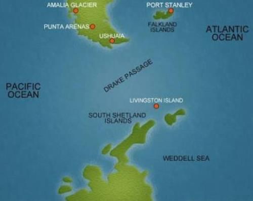
Which passage connects southwestern- Atlantic Ocean with south-eastern-Pacific Ocean?

Detailed Solution for Map Based Test - 5 - Question 28
Drake Passage is a body of water between South America Cape Horn and South Shetland Islands of Antarctica. It connects southwestern part of the Atlantic Ocean with the southeastern part of Pacific Ocean and it extends into the Southern Ocean.

Map Based Test - 5 - Question 29

Girnar hills, is the highest peak in which of the following states of India?

Detailed Solution for Map Based Test - 5 - Question 29
Also known as Girinagar or RevatakParvata is a group of mountains in the Junagadh District of Gujarat. These mountain ranges are considered sacred.

Map Based Test - 5 - Question 30

Which is the longest tunnel to carry water Asia between Yellampally barrage and Mallannasagar reservoir?

Detailed Solution for Map Based Test - 5 - Question 30
It has the longest tunnel to carry water in Asia -81km between the Yellampalli barrage and the Mallannasagar reservoir. It is designed in Telangana. It has an estimated cost of Rs.80,500 Cr, the costliest irrigation project to be taken up by any state.
1365 videos|1312 docs|1010 tests
Information about Map Based Test - 5 Page
In this test you can find the Exam questions for Map Based Test - 5 solved & explained in the simplest way possible. Besides giving Questions and answers for Map Based Test - 5, EduRev gives you an ample number of Online tests for practice

Top Courses for SSC CGL

Download as PDF

Top Courses for SSC CGL