UPSC Exam  >  UPSC Tests  >  Mock Test for UPSC Prelims 2025  >  Practice Test: Geography- 1 - UPSC MCQ

Practice Test: Geography- 1 - UPSC MCQ


Test Description

30 Questions MCQ Test Mock Test for UPSC Prelims 2025 - Practice Test: Geography- 1

Practice Test: Geography- 1 for UPSC 2024 is part of Mock Test for UPSC Prelims 2025 preparation. The Practice Test: Geography- 1 questions and answers have been prepared according to the UPSC exam syllabus.The Practice Test: Geography- 1 MCQs are made for UPSC 2024 Exam. Find important definitions, questions, notes, meanings, examples, exercises, MCQs and online tests for Practice Test: Geography- 1 below.
Solutions of Practice Test: Geography- 1 questions in English are available as part of our Mock Test for UPSC Prelims 2025 for UPSC & Practice Test: Geography- 1 solutions in Hindi for Mock Test for UPSC Prelims 2025 course. Download more important topics, notes, lectures and mock test series for UPSC Exam by signing up for free. Attempt Practice Test: Geography- 1 | 50 questions in 60 minutes | Mock test for UPSC preparation | Free important questions MCQ to study Mock Test for UPSC Prelims 2025 for UPSC Exam | Download free PDF with solutions
Practice Test: Geography- 1 - Question 1

Consider the following events with reference to the evolution of the Earth:

1. Initiation of photosynthesis.

2. Loss of the primordial atmosphere of the earth.

3. Degassing because of continuous volcanic eruptions.

4. Flooding of the atmosphere by oxygen.

5. Formation of the oceans

Which one of the following depicts the correct chronological order of the above events from past to present?

Detailed Solution for Practice Test: Geography- 1 - Question 1

There are three stages in the evolution of the present atmosphere. The loss of the primordial atmosphere marks the first stage. The earth's hot interior in the second stage contributed to the atmosphere's evolution. Finally, the composition of the atmosphere was modified by the living world through the process of photosynthesis.

  • The early atmosphere, with hydrogen and helium, is supposed to have been stripped off as a result of the solar winds. This happened not only in the case of the Earth but also in all the terrestrial planets, which are supposed to have lost their primordial atmosphere through the impact of solar winds.
  • During the cooling of the earth, gases and water vapour were released from the interior solid earth. The early atmosphere largely contained water vapour, nitrogen, carbon dioxide, methane, ammonia and very little free oxygen. The process through which the gases were outpoured from the interior is called degassing. Continuous volcanic eruptions contributed water vapour and gases to the atmosphere.
  • As the earth cooled, the water vapour released started getting condensed. The carbon dioxide in the atmosphere dissolved in rainwater, and the temperature further decreased, causing more condensation and more rain. The rainwater falling onto the surface got collected in the depressions to give rise to oceans. The earth’s oceans were formed within 500 million years from the formation of the earth.
  • Sometime around 3,800 million years ago, life began to evolve. However, around 2,500-3,000 million years before the present, the process of photosynthesis evolved. Life was confined to the oceans for a long time. Oceans began to have the contribution of oxygen through the process of photosynthesis.
  • Eventually, oceans were saturated with oxygen, and 2,000 million years ago, oxygen began to flood the atmosphere.
Practice Test: Geography- 1 - Question 2

Consider the following statements about the Shield volcanoes:

1. These volcanoes are mostly made up of Basalt.

2. They always result in explosive eruptions.

3. Mount Fuji in Japan is an example of the Shield Volcano. 

How many of the statements given above are correct?

Detailed Solution for Practice Test: Geography- 1 - Question 2

Volcanoes are classified on the basis of the nature of eruption and the form developed at the surface. Shield Volcanoes:

  • Statement 1 is correct: Barring the basalt flows, the shield volcanoes are the largest of all the volcanoes on the earth. These volcanoes are mostly made up of basalt, a type of lava that is very fluid when erupted. For this reason, these volcanoes are not steep.
  • Statement 2 is incorrect: They become explosive if water somehow gets into the vent; otherwise, they are characterised by low explosivity. The upcoming lava moves in the form of a fountain, throw out the cone at the top of the vent and develops into a cinder cone.
  • Statement 3 is incorrect: The Hawaiian volcanoes are the most famous examples of the shield volcano. Mount Fuji in Japan is an example of a Stratovolcano / composite cone type of volcano. Eruptions of this type of volcano vary between alternating layers of thick, highly viscous lavas and pyroclastic material. These eruptions are violent, due to high gas content. Escaping gases can get trapped in the highly viscous magma building up tremendous pressure in the volcano until finally an eruption occurs, blasting ash and other rocky-glassy debris miles into the air.
1 Crore+ students have signed up on EduRev. Have you? Download the App
Practice Test: Geography- 1 - Question 3

Consider the following statements with reference to the lightweight payment system:

1. It will operate independently of existing payment systems like RTGS, NEFT, and UPI.

2. It will process transactions that are critical to ensure the stability of the economy.

Which of the statements given above are correct?

Detailed Solution for Practice Test: Geography- 1 - Question 3
  • Statement 1 is correct: The lightweight payment system (LPSS) will operate independently of existing payment systems like RTGS, NEFT, and UPI, and aims to provide a portable and resilient solution during natural calamities and wartime situations. Real-time gross settlement (RTGS), National Electronic Fund Transfer (NEFT), and Unified Payments Interface (UPI) are dependent on complex wired networks backed by advanced IT infrastructure. "However, catastrophic events like natural calamities and war have the potential to render these payment systems temporarily unavailable by disrupting the underlying information and communication infrastructure. By conceptualising the LPSS, the central bank aims to ensure the availability of essential payment services and maintain economic stability in extreme and volatile situations.
  • Statement 2 is correct: This payment system would process transactions that are critical to ensure the stability of the economy, such as government and market-related transactions. The Reserve Bank of India said that this payment system can be operated from anywhere by a bare minimum staff in order to be prepared to face extreme situations such as natural calamities and war, and would be made active only on a need basis.
Practice Test: Geography- 1 - Question 4

Consider the following statements with reference to the World Press Freedom Index 2023:

1. The index was compiled by Reporters Without Borders.

2. Norway ranked first, and China ranked last in this edition of the index.

3. It also reflects the effects of fake content on press freedom.

How many of the statements given above are correct?

Detailed Solution for Practice Test: Geography- 1 - Question 4
  • Statement 1 is correct: The 21st edition of the World Press Freedom Index, which is compiled annually by Reporters Without Borders (RSF), sheds light on major and often radical changes linked to political, social and technological upheavals. According to the Index, the environment for journalism is “bad” in seven out of ten countries, and satisfactory in only three out of ten.
  • Statement 2 is incorrect: Norway is ranked first for the seventh year running. The last three places are occupied solely by Asian countries: Vietnam (178th), which has almost completed its hunt of independent reporters and commentators; China (down 4 at 179th), the world’s biggest jailer of journalists and one of the biggest exporters of propaganda content; and, to no great surprise, North Korea (180th).
  • Statement 3 is correct: The 2023 Index spotlights the rapid effects that the digital ecosystem’s fake content industry has had on press freedom. In 118 countries (two-thirds of the 180 countries evaluated by the Index), most of the Index questionnaire’s respondents reported that political actors in their countries were often or systematically involved in massive disinformation or propaganda campaigns.
Practice Test: Geography- 1 - Question 5

Which of the following statements are correct with reference to the Deception Detection Tests (DDT)?

1. The drugs used in the Narco Analysis test guarantee that the subject will speak only the truth.

2. Heart rate and Blood Pressure are among the parameters used in the Polygraph test analysis.

3. Brain mapping is based on the finding that the brain generates a unique brainwave pattern when a person encounters a familiar stimulus.

Select the correct answer using the codes given below:

Detailed Solution for Practice Test: Geography- 1 - Question 5
  • Statement 1 is incorrect: Narco-analysis test involves the intravenous administration of a drug (such as sodium pentothal, scopolamine and sodium amytal) that causes the subject to enter into various stages of anaesthesia. In the hypnotic stage, the subject becomes less inhibited and is more likely to divulge information, which would usually not be revealed in the conscious state. The drugs used do not guarantee that the subject will speak only the truth. The main drawback of this technique is that some persons are able to retain their ability to deceive even in the hypnotic state.
  • Statement 2 is correct: Polygraph is also called a lie detector test, but this term is a misnomer. The theory behind polygraph tests is that a guilty subject is more likely to be concerned with lying about the relevant facts about the crime, which in turn produces a hyper-arousal state which is picked up by a person trained in reading polygraph results. Measurement of hyperarousal state is based on a number of parameters such as heart rate, blood pressure, respiratory rate, skin conductance and electromyography.
  • Statement 3 is correct: The brain mapping test measures the changes in the electrical field potentials produced by the sum of the neuronal activity in the brain by means of electrodes placed on the surface of the skin covering the head and face. The changes directly related to specific perceptual or cognitive events are called event-related potentials. In simple words, it is based on the finding that the brain generates a unique brain-wave pattern when a person encounters a familiar stimulus. Commonly used method in India is called the Brain Electrical Activation Profile test, also known as the ‘P300 Waves test’.
Practice Test: Geography- 1 - Question 6

Consider the following countries:

1. United States

2. Canada

3. Germany

4. Japan

5. India

How many of the above are the members of the Group of Seven (G7) Countries?

Detailed Solution for Practice Test: Geography- 1 - Question 6

The Group of Seven (G7) serves as a forum to coordinate global policy, but experts are increasingly questioning the group’s relevance. The G7 is an informal grouping of advanced democracies that meets annually to coordinate global economic policy and address other transnational issues. The G7 is an informal bloc of industrialized democracies:

  • The United States
  • Canada
  • France
  • Germany
  • Italy
  • Japan
  • United Kingdom (UK)

Russia belonged to the forum from 1998 through 2014, when the bloc was known as the Group of Eight (G8), but it was suspended following its annexation of Ukraine’s Crimea region

Practice Test: Geography- 1 - Question 7

Consider the following:

1. Trade

2. Supply Chains

3. Clean Energy, Decarbonization, and Infrastructure

4. Tax and Anti-Corruption

How many of the above are the pillars on which Indo Pacific Economic Framework for Prosperity (IPEF) aims to focus on?

Detailed Solution for Practice Test: Geography- 1 - Question 7

In May 2022, the United States launched the Indo-Pacific Economic Framework for Prosperity (IPEF) with Australia, Brunei Darussalam, Fiji India, Indonesia, Japan, the Republic of Korea, Malaysia, New Zealand, Philippines, Singapore, Thailand, and Vietnam. This framework will advance resilience, sustainability, inclusiveness, economic growth, fairness, and competitiveness for our economies. Through this initiative, the IPEF partners aim to contribute to cooperation, stability, prosperity, development, and peace within the region. The 14 IPEF partners represent 40 percent of global GDP and 28 percent of global goods and services trade. The launch began discussions of future negotiations on the following pillars:

  • Trade
  • Supply Chains
  • Clean Energy, Decarbonization, and Infrastructure
  • Tax and Anti-Corruption.

The IPEF is designed to be flexible, meaning that IPEF partners are not required to join all four pillars.

Practice Test: Geography- 1 - Question 8

The ‘Business Ready (B-READY) project’ is an initiative of which one of the following organisations?

Detailed Solution for Practice Test: Geography- 1 - Question 8

The World Bank Group’s B-READY project is a benchmarking exercise aiming to provide a quantitative assessment of the business environment for private sector development. Its report will be published annually and cover most economies worldwide. The assessment will cover ten assessment topics following the typical life cycle of a firm from opening, operating (or expanding), and closing (or reorganising) a business.

Practice Test: Geography- 1 - Question 9

Which of the following statements are incorrect with reference to the International Organisation for Migration?

1. It promotes humane and orderly migration by providing services and advice to governments and migrants.

2. It was established in 1915 at the time of World War I. 

Select the correct answer using the codes given below:

Detailed Solution for Practice Test: Geography- 1 - Question 9

Statement 1 is correct: The International Organization for Migration (IOM) is the leading intergovernmental organization in the field of migration and works closely with governmental, intergovernmental and non-governmental partners. With 175 member states, a further 8 states holding observer status and offices in 171 countries, IOM is dedicated to promoting humane and orderly migration for the benefit of all. It does so by providing services and advice to governments and migrants. IOM works in the four broad areas of migration management:

  • Migration and development
  • Facilitating migration
  • Regulating migration
  • Forced migration.

Statement 2 is incorrect: Established in 1951, IOM is the leading intergovernmental organization in the field of migration and works closely with governmental, intergovernmental and nongovernmental partners. Amy E. Pope of the United States of America has begun her five-year term as the eleventh Director General (DG) of the International Organization for Migration (IOM). She became the first woman to become Director General in IOM’s 72-year history.

Practice Test: Geography- 1 - Question 10

Consider the following statements with reference to Insurance products in India:

1. Bima Sugam is an online portal for all insurance-related queries, policy purchase, claim settlement and insurance advice.

2. Each Gram Panchayat would have a ‘Bima Vahak’ tasked to sell and service simple parametric bundled insurance products.

3. Bima Vistar will be a social safety net to target the untapped Geographies in the country.

How many of the statements given above are correct?

Detailed Solution for Practice Test: Geography- 1 - Question 10
  • Statement 1 is correct: Bima Sugam portal is an online portal and a one-stop shop for all insurance related queries, policy purchase, claim settlement and insurance advice. It is envisioned as a trusted platform by the IRDAI. Web aggregators, brokers, insurance agents, bank agents, etc would act as facilitators on this platform for selling insurance policies. The portal would provide all such facilities to policyholders having an e-insurance account (E-IA).
  • Statement 2 is correct: Bima Vahak is another initiative by the IRDAI which would help reach the last mile. Each Gram Panchayat would have a 'Bima Vahak' who would be tasked to sell and service simple parametric bundled insurance. Bima Vahak intends to form a womencentric insurance distribution channel. The initiative is likely to foster greater trust and build awareness about insurance products in the rural areas of India.
  • Statement 3 is correct: A social safety net product called "Bima Vistaar'' targeting the untapped geographies is in the works. IRDAI is working on to develop an affordable, accessible and comprehensive cover - Bima Vistaar for rural population in the event of natural disasters, such as floods, and earthquakes etc.
Practice Test: Geography- 1 - Question 11

Consider the following statements with reference to the Vivad se Vishwas II scheme:

1. It was launched by the Ministry of Corporate Affairs.

2. This scheme will apply to all domestic contractual disputes where one of the parties is either the Government of India or an organisation working under its control.

Which of the statements given above are correct?

Detailed Solution for Practice Test: Geography- 1 - Question 11
  • Statement 1 is incorrect: The Department of Expenditure, Ministry of Finance, has launched the scheme, “Vivad se Vishwas II – (Contractual Disputes). The scheme aims to settle contractual disputes of government and government undertakings, wherein an arbitral award is under challenge in a court, a voluntary settlement scheme with standardized terms will be introduced. This will be done by offering graded settlement terms depending on the pendency level of the disputes.
  • Statement 2 is correct: The scheme will apply to all domestic contractual disputes where one of the parties is either the Government of India or an organisation working under its control. Government e-Marketplace (GeM) has developed a dedicated web page for the implementation of this scheme. Eligible claims shall be processed only through GeM. For non-GeM contracts of the Ministry of Railways, contractors may register their claims on IREPS.
Practice Test: Geography- 1 - Question 12

Which one of the following is the major objective of ‘Operation Samudragupta’?

Detailed Solution for Practice Test: Geography- 1 - Question 12

India began its fight against drug trafficking under Operation Samudragupta. This is a joint operation between the Indian Navy and the Narcotics Control Bureau (NCB). It is a successful attempt by the government to stop maritime infiltration of contraband. India is located between two of the largest Opium producing and trafficking regions, namely the “GOLDEN CRESCENT” in the west and “GOLDEN TRIANGLE” in the east.
Golden Crescent Countries: Iran, Afghanistan and Pakistan
Golden Triangle Countries: Myanmar, Thailand and Laos

Practice Test: Geography- 1 - Question 13

Consider the following rivers:

1. Nagwati

2. Rukmawati

3. Sabarmati

4. Tapti

How many of the above rivers drain into the Gulf of Khambhat?

Detailed Solution for Practice Test: Geography- 1 - Question 13

Gulf of Khambhat is a trumpet-shaped gulf of the Arabian Sea, indenting northward the coast of Gujarat state, western India, between Mumbai (Bombay) and the Kathiawar Peninsula. The gulf receives many rivers, including the:

  • Sabarmati
  • Mahi
  • Narmada
  • Tapti

Its shape and its orientation in relation to the southwest monsoon winds account for its high tidal range and the high velocity of the entering tides. Shoals and sandbanks are treacherous to navigation, and all the gulf ports have suffered from silting caused by tides and flood torrents from the rivers.

Practice Test: Geography- 1 - Question 14

Consider the following statements with reference to the Har Ghar Jal Programme:

1. It is implemented by the Jal Jeevan Mission under the Ministry of Jal Shakti.

2. The program aims to provide every rural household with affordable and regular access to an adequate supply of safe drinking water through taps.

Which of the statements given above are correct?

Detailed Solution for Practice Test: Geography- 1 - Question 14
  • Statement 1 is correct: The Har Ghar Jal Programme, implemented by the Jal Jeevan Mission under the Ministry of Jal Shakti. Jal Jeevan Mission is envisioned to provide safe and adequate drinking water through individual household tap connections by 2024 to all households in rural India. The programme will also implement source sustainability measures as mandatory elements, such as recharge and reuse through greywater management, water conservation, and rainwater harvesting.
  • Statement 2 is correct: The program aims to provide every rural household with affordable and regular access to an adequate supply of safe drinking water through taps. The program's components align with the WHO/UNICEF Joint Monitoring Programme for Water Supply, Sanitation, and Hygiene (JMP) to monitor progress on SDG 6.1 for safely managed drinking water services.
Practice Test: Geography- 1 - Question 15

Consider the following pairs: Type of Earthquake Area of Occurrence

1. Tectonic : Near tectonic boundaries

2. Collapse : Areas near a reservoir

3. Explosion : Nuclear test sites

How many of the above pairs are correctly matched?

Detailed Solution for Practice Test: Geography- 1 - Question 15

Types of Earthquakes include tectonic earthquakes, collapse earthquakes, explosion earthquakes and reservoirinduced earthquakes.

  • Tectonic earthquakes - The most common ones are the tectonic earthquakes. These are generated due to the sliding of rocks along a fault plane. A special class of tectonic earthquake is sometimes recognised as a volcanic earthquake. However, these are confined to areas of active volcanoes. Hence, pair 1 is correct.
  • Collapse earthquakes - In areas of intense mining activity, sometimes the roofs of underground mines collapse causing minor tremors. These are called collapse earthquakes. Reservoir-induced earthquakes -The earthquakes that occur in the areas of large reservoirs are referred to as reservoir-induced earthquakes. Hence, pair 2 is incorrect.
  • Explosion earthquakes - Ground shaking may also occur due to the explosion of chemical or nuclear devices. Such tremors are called explosion earthquakes. Hence, pair 3 is correct.
Practice Test: Geography- 1 - Question 16

With reference to landscape evolution in deserts, consider the following statements:

1. Pediments are depositional landforms.

2. Inselbergs are remnants of mountains.

Which of the statements given above are correct?

Detailed Solution for Practice Test: Geography- 1 - Question 16
  • Statement 1 is incorrect: Gently inclined rocky floors close to the mountains at their foot with or without a thin cover of debris, are called pediments. Such rocky floors form through the erosion of the mountainfront through a combination of lateral erosion by streams and sheet flooding.
  • Statement 2 is correct: An inselberg is an isolated hill that stands above welldeveloped plains and appears not unlike an island rising from the sea. The early German explorers of southern Africa were impressed by such features, and they dubbed the domed or castlelike highlands inselbergs. Spectacular examples include Uluru/Ayers Rock and the Olga Rocks in central Australia. Inselbergs are remnants of mountains. Inselbergs are relict features. They have maintained their relief as the adjacent surrounding landscape was lowered.
Practice Test: Geography- 1 - Question 17

Consider the following statements with reference to the Science and Engineering Research Board:

1. It is an executive body formed by a resolution of the government.

2. It tries to position science and technology as the fulcrum for social and economic change in the country.

Which of the statements given above are incorrect?

Detailed Solution for Practice Test: Geography- 1 - Question 17
  • Statement 1 is incorrect: The Science and Engineering Research Board (SERB) is a statutory body established through an Act of Parliament. Supporting basic research in emerging areas of Science & Engineering are the primary and distinctive mandate of the Board. The Board structure, with both financial and administrative powers vested in the Board, would enable quicker decisions on research issues, greatly improving thereby our responsiveness to the genuine needs of the research scientists and the S&T system.
  • Statement 2 is correct: The vision of the board is to position science and technology as the fulcrum for social and economic change by supporting relevant, competitive and quality scientific research and development. The mission of the board is to raise the quality and footprint of Indian science and engineering to the highest global levels in an accelerated mode, through calibrated support for research and development.
Practice Test: Geography- 1 - Question 18

Consider the following regarding the surface of the Earth:

1. The unevenness of the Earth's surface is attributed to the movement of the Earth’s crust.

2. Exogenic forces contribute only to the degradation of relief features.

3. Human activities have had no impact on the Earth's surface.

Which of the statements given above are incorrect?

Detailed Solution for Practice Test: Geography- 1 - Question 18
  • Statement 1 is correct: The unevenness of the Earth's surface is primarily attributed to the dynamic nature of the Earth's crust. The movement of Earth's crust, both vertically and horizontally, plays a crucial role in shaping the topography and relief features of its surface. It moved a bit faster in the past than the rate at which it is moving now. The differences in the internal forces operating from within the earth which built up the crust have been responsible for the variations in the outer surface of the crust.
  • Statement 2 is incorrect: Exogenic forces, driven by external factors such as sunlight, contribute to both the degradation (wearing down) and aggradation (filling up) of relief features on the Earth's surface. Endogenic forces are mainly responsible for landbuilding processes. This distinction emphasizes the collaborative yet opposing actions of these forces in shaping the Earth's surface.
  • Statement 3 is incorrect: Human activities have significantly impacted the Earth's surface, leading to the degradation of its potential. Overuse of resources and environmental damage caused by human actions have accelerated the diminishing of the Earth's natural balance and potential for future sustenance.
Practice Test: Geography- 1 - Question 19

Consider the following statements with reference to the Data Security Council of India:

1. It is a statutory body on data protection in India.

2. This council runs certification programmes for cyber forensic professionals.

Which of the statements given above are correct?

Detailed Solution for Practice Test: Geography- 1 - Question 19
  • Statement 1 is incorrect: Data Security Council of India (DSCI), is a not-forprofit, industry body on data protection in India, setup by nasscom, committed to making the cyberspace safe, secure and trusted by establishing best practices, standards and initiatives in cyber security and privacy. To further its objectives, DSCI engages with governments and their agencies, regulators, industry sectors, industry associations and think tanks for policy advocacy, thought leadership, capacity building and outreach activities.
  • Statement 2 is correct: The aim of the council is to strengthen thought leadership in cyber security and privacy, DSCI develops best practices and frameworks, published studies, surveys and papers. It builds capacity in security, privacy and cyber forensics through training and certification programs for professionals and law enforcement agencies and engages stakeholders through various outreach initiatives including events,awards, chapters, consultations and membership programs. DSCI also endeavors to increase India’s share in the global security product and services market through global trade development initiatives. These aim to strengthen the security and privacy culture in India.
Practice Test: Geography- 1 - Question 20

Which of the following statements best describes the term ‘Nunataks’?

Detailed Solution for Practice Test: Geography- 1 - Question 20

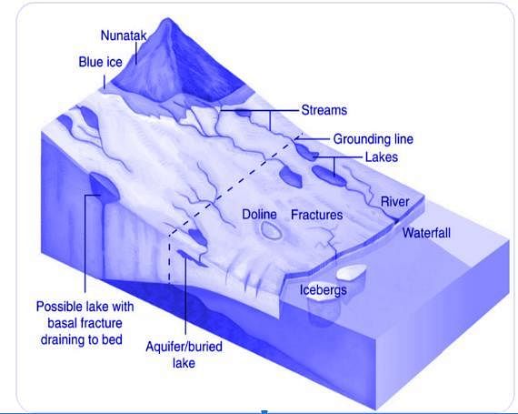
Nunataks: The higher peaks and mounds surrounded by ice from all sides are called nunataks. They look like scattered small islands amid extensive ice masses. That is why they are also called glacial islands. They decrease in size due to erosion caused by glacial lateral erosion and frost action.

Practice Test: Geography- 1 - Question 21

Consider the following statements with reference to the International Telecommunication Union (ITU):

1. It is the United Nations specialized agency for information and communication technologies.

2. The union allocates global radio spectrum and satellite orbits.

Which of the statements given above are correct?

Detailed Solution for Practice Test: Geography- 1 - Question 21
  • Statement 1 is correct: The International Telecommunication Union (ITU) is the United Nations specialized agency for information and communication technologies – ICTs. ITU is a unique platform for global public-private partnerships. By joining ITU, you can become part of a community of more than 20'000 professionals. At ITU, members from the public and private sectors are working together to help shape the future ICT policy and regulatory environment, global standards, and best practices to help spread access to ICT services.
  • Statement 2 is correct: The Union was founded in 1865 to facilitate international connectivity in communications networks, we allocate global radio spectrum and satellite orbits, develop the technical standards that ensure networks and technologies seamlessly interconnect, and strive to improve access to ICTs to underserved communities worldwide. Every time you make a phone call via mobile, access the Internet or send an email, you are benefitting from the work of ITU.
Practice Test: Geography- 1 - Question 22

Consider the following pairs:

How many of the pairs given above are correct?

Detailed Solution for Practice Test: Geography- 1 - Question 22
  • Pair 1 is correct: Sital Sasthi is a sacred Hindu festival celebrated in Odisha. This week-long special festival highlights the marriage of Lord Shiva and Goddess Parvati. People observing this festival believe that Lord Shiva represents the scorching heat of summer while Goddess Parvati signifies the first rain. So, this holy and lavish wedding is observed for a good monsoon. Sital Sasthi is a celebration wherein Lord Shiva and Goddess Parvati are adopted by two families, and their wedding is solemnized with the involvement of rituals. After the marriage is performed, the God and Goddess are then carried around the city via a procession.
  • Pair 2 is correct: Bihu is the name for the National Festival of Assam which is one of the most beautiful states of India which is reckoned for tea gardens, mighty Brahmaputra River and Lush green forests. Also the state of Assam is reckoned for the Bihu festival that depicts a set of three different cultural festivals of the state. The origin of the term ‘Bihu’ came from the Sanskrit word that means ‘Vishu’. It is the cheerful festival of Assam that is celebrated by the locals irrespective of caste, creed and beliefs.
  • Pair 3 is incorrect: Pongal is a harvest festival celebrated by the Tamil community. It is a celebration to thank the Sun, Mother Nature and the various farm animals that help to contribute to a bountiful harvest. Celebrated over four days, Pongal also marks the beginning of the Tamil month called Thai, which is considered an auspicious month. It usually falls on the 14th or 15th of January each year.
Practice Test: Geography- 1 - Question 23

Consider the following statements:

Statement-I: Mauritius and Reunion Islands of the Indian Ocean are the coral islands.

Statement-II: The coral islands are very much lower and emerge just above the water surface.

Which one of the following is correct in respect of the above statements? 

Detailed Solution for Practice Test: Geography- 1 - Question 23
  • Statement-I is incorrect: Mauritius and Réunion are volcanic islands located in the Indian Ocean. Mauritius is situated to the east of the continent of Africa. It is formed by volcanic activity and is part of a submerged mountain range that extends beneath the Indian Ocean. Réunion, a French overseas territory and is located further to the southwest of Mauritius. Like Mauritius, Réunion is also a volcanic island, and its Piton de la Fournaise is one of the most active volcanoes in the world.
  • Statement-II is correct: Unlike the volcanic islands, the coral islands are very much lower and emerge just above the water’s surface. These islands, built up by coral animals of various species, are found both near the shores of the mainland and in the midst of oceans. Coral islands include the Marshall Islands, Gilbert and Ellice Islands of the Pacific; Bermuda in the Atlantic and the Laccadives and Maldives of the Indian Ocean.
Practice Test: Geography- 1 - Question 24

With reference to a Cyclone, consider the following statements:

1. The Indian subcontinent is exposed to nearly 45 percent of the world’s tropical cyclones.

2. The air circulates inward in an anticlockwise direction in the Northern hemisphere and clockwise in the Southern hemisphere in a cyclone.

3. Cyclones are classified on the basis of the wind speed and their capacity to cause damage.

Which of the statements given above are correct?

Detailed Solution for Practice Test: Geography- 1 - Question 24

Cyclones are classified as
(i) extratropical cyclones (also called temperate cyclones);
(ii) tropical cyclones.

  • Tropical cyclones are the progeny of ocean and atmosphere, powered by the heat from the sea; and driven by easterly trades and temperate westerlies, high planetary winds and their own fierce energy.
  • Tropical cyclones are large-scale weather systems developing over tropical or subtropical waters, where they get organised into surface wind circulation.
  • Extra tropical cyclones occur in temperate zones and high-latitude regions, though they are known to originate in the Polar Regions.

Statement 1 is incorrect: The Indian subcontinent is one of the worst affected regions in the world. The subcontinent, with a long coastline of 8041 kilometres, is exposed to nearly 10 per cent of the world’s tropical cyclones.

Statement 2 is correct: Cyclones are caused by atmospheric disturbances around a low-pressure area distinguished by swift and often destructive air circulation. Cyclones are usually accompanied by violent storms and bad weather. The air circulates inward in an anticlockwise direction in the Northern hemisphere and clockwise in the Southern hemisphere. Statement 3 is correct: In India, cyclones are classified by:

  • Strength of associated winds,
  • Storm surges
  • Exceptional rainfall occurrences

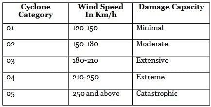
Cyclones are classified into five different levels on the basis of wind speed. They are further divided into the following categories according to their capacity to cause damage:-

Practice Test: Geography- 1 - Question 25

Consider the following statements:

1. Nuclear and Radiological Emergency can arise while using radiation sources at Hospitals, Industries or Agriculture.

2. Infra-red rays are ionising rays and cause severe damage to human bodies.

Which of the statements given above are correct?

Detailed Solution for Practice Test: Geography- 1 - Question 25

The growth in the application of nuclear science and technology in the fields of power generation, medicine, industry, agriculture, research and defence has led to an increase in the risk of occurrence of Nuclear and Radiological emergencies.

  • Statement 1 is correct: Nuclear and Radiological Emergencies can arise in a nuclear facility at the plant level, leading to plant/ site or offsite emergencies. It can also take place while using radiation sources, either at Hospitals, Industries, Agriculture or Research Institutions, due to loss or misplacement or due to faulty handling. The other events that can lead to a Nuclear or Radiological Emergency in the public domain include an accident of a vehicle carrying radioactive/nuclear material, due to an orphan source, i.e. the source which is not under regulatory control or due to usage of radiation source/radioactive material in Malevolant activities. Any radiation incident resulting in or having the potential to result in exposure and/or contamination of the workers or the public in excess of the respective permissible limits can lead to a nuclear/radiological emergency.
  • Statement 2 is incorrect: Sunlight feels warm because our body absorbs the infrared rays it contains. But, infrared rays do not produce ionisation in body tissue. In contrast, ionising radiation can impair the normal functioning of the cells or even kill them. The amount of energy necessary to cause significant biological effects through ionisation is so small that our bodies cannot feel this energy as in the case of infrared rays, which produce heat.
Practice Test: Geography- 1 - Question 26

‘It drains the largest number of glaciers and mountain slopes of the Karakorum, Ladakh, Zaskar and Himalayan Ranges. Originating from the Kailash Mountain, it flows in a constricted valley north-westward through Tibet, where it is called Singi Khamban or Lion’s mouth.’

Which of the following rivers is best described in the passage given above?

Detailed Solution for Practice Test: Geography- 1 - Question 26

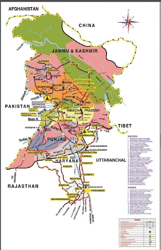
The Indus is the westernmost River system in the subcontinent. Jhelum, Chenab, Ravi, Beas and Satluj are its main tributaries. The Indus originates from the Bokhar Chu (glacier) on the northern slopes of Mt. Kailash (6714m). It drains the largest number of glaciers and mountain slopes of the Karakorum, Ladakh, Zaskar and Himalayan Ranges. Originating from the Kailash Mountain, it flows in a constricted valley northwestward through Tibet, where it is called Singi Khamban or Lion’s mouth. In Ladakh, it follows a long, nearly straight course between the Ladakh range and the Zaskar range. Downward; the Indus crosses the central Himalayan range through a huge synclinal gorge. The River passes by the Nanga-Parbat and turns southwest to enter Pakistan

Practice Test: Geography- 1 - Question 27

Consider the following statements:

1. A marginal worker is a person who works for less than 183 days in a year.

2. The Labour Force Participation Rate of women in rural areas is higher than that of urban areas.

Which of the statements given above are correct?

Detailed Solution for Practice Test: Geography- 1 - Question 27
  • Statement 1 is correct: The population of India, according to their economic status, is divided into three groups, namely, main workers, marginal workers and nonworkers. A Main Worker is a person who works for at least 183 days (or six months) in a year. A Marginal Worker is a person who works for less than 183 days (or six months) in a year.
  • Statement 2 is correct: The labour force participation rate is the portion of the working population in the 16-64 years' age group in the economy currently in employment or seeking employment. The LFPR of women in rural areas was 41.5 in 2022-23 while it was 25.4 for urban areas in the same period.
Practice Test: Geography- 1 - Question 28

Consider the following statements:

1. The Gross Enrolment Ratio for females in higher education has been consistently greater than that of males in the last 5 years.

2. The male-female gap in literacy rate in India has consistently reduced since Independence.

Which of the statements given above are correct?

Detailed Solution for Practice Test: Geography- 1 - Question 28

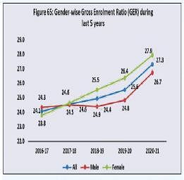
Gross Enrolment Ratio (GER) refers to the total enrolment in a specific level of education, regardless of age, expressed as a percentage of the eligible official schoolage population corresponding to the same level of education in a given school year. Table: Gender-wise GER figures of All India Survey on Higher Education (AISHE) and Literacy rate in India since independence

  • Statement 1 is correct: The Gross Enrolment Ratio for females in higher education has been consistently greater than that of males since 2017-18.

  • Statement 2 is incorrect: The malefemale gap in literacy rate in India has remained inconsistent since Independence.
Practice Test: Geography- 1 - Question 29

Consider the following pairs:

How many of the above pairs are correctly matched?

Detailed Solution for Practice Test: Geography- 1 - Question 29
  • Pair 1 is correct: Similipal Tiger Reserve is located within the Mayurbhanj District, in the Northern-most part of Odisha. The terrain is mostly undulating and hilly, interspersed with open grasslands and wooded areas. The inclined plateau has risen abruptly from the low coastal plains of the District. The steep side faces the Bay of Bengal and run northwards to finally merge with Chhota Nagpur. The water level is high and the tract is woven with perennial water sources converging into rivers like Budhabalanga, Salandi and many tributaries of Baitarani river flowing from the Reserve.
  • Pair 2 is incorrect: Valmiki Tiger Reserve is located in the foothills of Himalayas in the north-west corner of Bihar, spread over Northern part of the West Champaran district. The terrain is undulating with a rich soil. Rivers Gandak, Pandai, Manor, Harha, Masan and Bhapsa flow through various parts of the reserve. By and large, the reserve is spread over lower Shivalik region with a deep water table. The tract is porous with boulders and sand deposits.
  • Pair 3 is incorrect: Mukundara Hills Tiger Reserve, located in Rajasthan, is named after two continuous flat topped, almost parallel hills with narrow central ridges, forming part of the Vindhyan range and extending from river Chambal to Kalisindh, with a length of almost 80 km and the width ranging from 2 to 5 km. The tiger reserve was constituted in the year 2013 which encompasses the area of Mukundara National Park, Dara Sanctuary, Jawahar Sagar Sanctuary and part of Chambal Sanctuary (from Garadia Mahadev to Jawahar Sagar Dam), forming its core / critical tiger habitat. The forests of Kota, Chittorgarh and Jhalawar are included in the buffer.
  • Pair 4 is correct: The Bandhavgarh Tiger Reserve is located between the Vindhyan and Satpura ranges of Madhya Pradesh. The habitat is characterised by valleys, hills and plains, with the Bandhavgarh fort prominently seen as a major landmark. The habitat consists of tropical moist, deciduous forests with sal, mixed forest and grasslands. The habitat also has several archaeological monuments.
Practice Test: Geography- 1 - Question 30

Consider the following statements in the context of Central Highlands:

1. The general slope of the highlands is towards the south and south-east.

2. Musi river basin forms the majority part of the region.

Which of the statements given above are correct?

Detailed Solution for Practice Test: Geography- 1 - Question 30

Statement 1 is incorrect. Central Highlands: also called the Madhya Bharat Pathar or Madhya Bharat Plateau. It slopes towards the north and northeastern directions. Musi River or Musinuru is a tributary of the Krishna River in the Deccan Plateau, flowing through Telangana state in India. Hyderabad stands on the banks of Musi river Hence, Statement 2 is incorrect.

Central Highlands are to the east of the Marwar or Mewar Upland and the north of the Narmada river. It covers the major portion of the Malwa plateau. Most of the plateau comprises the basin of the Chambal river which flows in a rift valley. The Kali Sindh, flowing from Rana Pratap Sagar, The Banas flowing through Mewar plateau, and The Parwan and the Parbati flowing from Madhya Pradesh are Chambal's main tributaries. It is a rolling plateau with rounded hills composed of sandstone. Thick forests grow here. To the north are the ravines or badlands of the Chambal river and Satpura ranges, to the south is the Deccan plateau, and to the west are Aravalli ranges

View more questions
16 videos|4 docs|70 tests
Information about Practice Test: Geography- 1 Page
In this test you can find the Exam questions for Practice Test: Geography- 1 solved & explained in the simplest way possible. Besides giving Questions and answers for Practice Test: Geography- 1, EduRev gives you an ample number of Online tests for practice

Top Courses for UPSC

Download as PDF

Top Courses for UPSC