UPSC Exam  >  UPSC Tests  >  Geography for UPSC CSE  >  Test: Mountains Peaks & Ranges - UPSC MCQ

Test: Mountains Peaks & Ranges - UPSC MCQ


Test Description

25 Questions MCQ Test Geography for UPSC CSE - Test: Mountains Peaks & Ranges

Test: Mountains Peaks & Ranges for UPSC 2024 is part of Geography for UPSC CSE preparation. The Test: Mountains Peaks & Ranges questions and answers have been prepared according to the UPSC exam syllabus.The Test: Mountains Peaks & Ranges MCQs are made for UPSC 2024 Exam. Find important definitions, questions, notes, meanings, examples, exercises, MCQs and online tests for Test: Mountains Peaks & Ranges below.
Solutions of Test: Mountains Peaks & Ranges questions in English are available as part of our Geography for UPSC CSE for UPSC & Test: Mountains Peaks & Ranges solutions in Hindi for Geography for UPSC CSE course. Download more important topics, notes, lectures and mock test series for UPSC Exam by signing up for free. Attempt Test: Mountains Peaks & Ranges | 25 questions in 35 minutes | Mock test for UPSC preparation | Free important questions MCQ to study Geography for UPSC CSE for UPSC Exam | Download free PDF with solutions
Test: Mountains Peaks & Ranges - Question 1

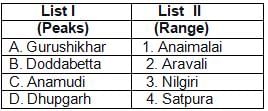
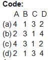
Match the following

Detailed Solution for Test: Mountains Peaks & Ranges - Question 1
  • Guru Shikhar, a peak in the Arbuda Mountains of Rajasthan, is the highest point of the Aravali Range. It rises to an elevation of 1,722 metres.

  • Doddabetta is the highest mountain in the Nilgiri Hills at 2,637 metres. There is a reserved forest area around the peak. It is 9 km from Ooty, on the Ooty-Kotagiri Road in the Nilgiris district of Tamil Nadu, India.

  • Anamudi or AnaiMudi is a mountain located in the Indian state of Kerala. It is the highest peak in the Western Ghats and South India, at an elevation of 2,695 metres, and a topographic prominence of 2,479 metres.

  • Mount Dhupgarh or Dhoopgarh is the highest point in the Satpura Range and Madhya Pradesh, India. Located in Pachmarhi, it has an elevation of 1,350 metres.

Test: Mountains Peaks & Ranges - Question 2

Doddabetta Peak is located in the

Detailed Solution for Test: Mountains Peaks & Ranges - Question 2
  • Nilgiri Hills are a range of mountains with at least 24 peaks above 2,000 metres (6,600 ft), in the Westernmost part of Tamil Nadu state at the junction of Karnataka and Kerala states in Southern India. They are part of the larger Western Ghats mountain chain making up the southwestern edge of the Deccan Plateau.

1 Crore+ students have signed up on EduRev. Have you? Download the App
Test: Mountains Peaks & Ranges - Question 3

The Raman Peak is situated in

Detailed Solution for Test: Mountains Peaks & Ranges - Question 3

Raman Peak is the name given to a submarine mountain peak situated in the Arabian Sea.

Test: Mountains Peaks & Ranges - Question 4

The highest peak of south India is

Detailed Solution for Test: Mountains Peaks & Ranges - Question 4

Anamudi is the highest peak in South India. It is situated at an elevation of 2695 metres and located in Kerala.

Test: Mountains Peaks & Ranges - Question 5

Which one of the following peaks is the highest?

Detailed Solution for Test: Mountains Peaks & Ranges - Question 5

Godwin Austen (K2) is the highest peak in the given options. It is the world’s second tallest peak It is located in the Karakoram Range of the Himalaya in Northern Kashmir. Its height is 8611m.

Test: Mountains Peaks & Ranges - Question 6

Considering the locations of mountains in India, which one among the following is in the right sequence from south to north?

Detailed Solution for Test: Mountains Peaks & Ranges - Question 6
Doddabetta is the highest mountain in the Nilgiri Hills (Tamil Nadu)at 2,637 metres. The Vindhyas run across most of central India. The Dhaulagiri massif in Nepal extends 120 km from the Kaligandaki River west to the Bheri. Mt. Kailash peak is standing in the remote south-west corner of Tibet in the Himalayan Mountains.

Test: Mountains Peaks & Ranges - Question 7

Arrange the following mountain ranges from north to south order

and select the correct answer from the codes:

1. Dhauladhar

2. Ladakh

3. PirPanjal

4. Zaskar

Codes:

Detailed Solution for Test: Mountains Peaks & Ranges - Question 7
From north to south

Ladakh -> Zaskar ->Pirpanjal ->Dhauladhar

Test: Mountains Peaks & Ranges - Question 8

Which one of the following statements is not correct regarding the Himalayas?

Detailed Solution for Test: Mountains Peaks & Ranges - Question 8

The Himalayas consist of parallel mountain ranges: the Shivalik Hills on the south; the Lower Himalayan Range; the Great Himalayas, which is the highest and central range; and the Tibetan Himalayas on the north. The Karakoram is generally considered separate from the Himalayas.

Test: Mountains Peaks & Ranges - Question 9

Which one of the following mountain ranges is spread over only one state in India?

Detailed Solution for Test: Mountains Peaks & Ranges - Question 9
Ajanta Mountain range is spread over only one State i.e. Maharashtra in India.

Test: Mountains Peaks & Ranges - Question 10

Which one of the following is the oldest mountain range in India?

Detailed Solution for Test: Mountains Peaks & Ranges - Question 10

The Aravalli Range is the oldest fold of mountains in India.

Test: Mountains Peaks & Ranges - Question 11

Which one of the following statements is correct?


Detailed Solution for Test: Mountains Peaks & Ranges - Question 11

The Himalayas have risen from the Tethys Sea when the Sea got compressed.


Test: Mountains Peaks & Ranges - Question 12

What is the name given to the foothills zone of Himalayas?

Detailed Solution for Test: Mountains Peaks & Ranges - Question 12
Answer:
The name given to the foothills zone of the Himalayas is the Siwalik Range.
Explanation:
The Siwalik Range is a sub-mountain range located in the southern foothills of the Himalayas. It stretches across several countries including India, Nepal, Bhutan, and Pakistan. The Siwalik Range is composed of sedimentary rocks and is known for its rich biodiversity and fossil deposits.
Here is a detailed explanation of the Siwalik Range:
1. Location:
- The Siwalik Range lies between the Terai plains and the Lesser Himalayas.
- It extends from the Yamuna River in the west to the Brahmaputra River in the east.
2. Formation and Composition:
- The Siwalik Range was formed due to the collision of the Indian and Eurasian tectonic plates.
- It is made up of sedimentary rocks like sandstone, shale, and conglomerate.
3. Geographical Features:
- The Siwalik Range is characterized by low hills and valleys.
- It acts as a transition zone between the plains and the mountains.
- The range is marked by numerous rivers and streams.
4. Biodiversity:
- The Siwalik Range is known for its diverse flora and fauna.
- It is home to a variety of plant species, including sal, teak, and bamboo.
- The range also supports a wide range of animal species, such as tigers, elephants, deer, and birds.
5. Fossil Deposits:
- The Siwalik Range is renowned for its rich fossil deposits.
- Fossils of prehistoric animals like elephants, rhinoceros, and giant tortoises have been found in the range.
- These fossils provide valuable insights into the region's past biodiversity and evolution.
In conclusion, the foothills zone of the Himalayas is known as the Siwalik Range. It is an important geographical region with unique features, diverse ecosystems, and significant fossil deposits.
Test: Mountains Peaks & Ranges - Question 13

The Mt. Everest is situated in the region of

Detailed Solution for Test: Mountains Peaks & Ranges - Question 13

The Mt. Everest is situated in the region of Nepal Himalayas

Test: Mountains Peaks & Ranges - Question 14

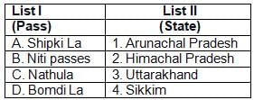
Match List-I with List-II and select the correct answer from the

codes given below:
Detailed Solution for Test: Mountains Peaks & Ranges - Question 14
  • Shipki La is a mountain pass and border post on the India- China border. It is located in Kinnaur district in the state of Himachal Pradesh, India. Niti pass is in Uttarakhand, Nathula pass is in Sikkim and Bomdi La is in Arunachal Pradesh.

Test: Mountains Peaks & Ranges - Question 15

What are Kingri-Bingri, Neeti-Mana?

Detailed Solution for Test: Mountains Peaks & Ranges - Question 15
Kingri - Bingri, Neeti - Mana are Passes.

Test: Mountains Peaks & Ranges - Question 16

Which of the following passes is in Arunachal Pradesh?

Detailed Solution for Test: Mountains Peaks & Ranges - Question 16
Bamdila pass is in Arunachal Pradesh.

Test: Mountains Peaks & Ranges - Question 17

Among the following which mountain range is the oldest in India?

Detailed Solution for Test: Mountains Peaks & Ranges - Question 17
Aravali mountain range is the oldest mountain range in India.

Test: Mountains Peaks & Ranges - Question 18

Which of the following landforms occupy the North-Western parts of Bihar State?

Detailed Solution for Test: Mountains Peaks & Ranges - Question 18
Someshwar Hilly Range occupies the North-Western part of Bihar State.

Test: Mountains Peaks & Ranges - Question 19

Which of the following statements about Nathu La Pass are correct?

1. It links Sikkim with Tibet

2. It was the main artery of the ancient Silk Route

3. It was reopened in the year 2006

Select the correct answer using the codes given below:

Detailed Solution for Test: Mountains Peaks & Ranges - Question 19
  • Nathu La is a mountain pass in the Himalayas. It connects the Indian state of Sikkim with China’s Tibet Autonomous Region. The pass, at 4,310 m (14,140 ft) above mean sea level, forms a part of an offshoot of the ancient Silk Road.

  • Nathumeans“listening ears” and La means“pass” in Tibetan. On the Indian side, the pass is 54 km (34 mi) east of Gangtok, the capital of Sikkim. Only citizens of India can visit the pass, and then only after obtaining a permit in Gangtok.

Test: Mountains Peaks & Ranges - Question 20

Match the following

(d)(c)

Detailed Solution for Test: Mountains Peaks & Ranges - Question 20
  • Zoji La is a high mountain pass in Jammu and Kashmir, India, located on the Indian National Highway 1D between Srinagar and Leh in the western section of the Himalayan mountain range.

  • Bara-lacha la also known as Bara-lacha Pass, or BārāLācha La, is a high mountain pass in Zanskar range, connecting Lahaul district in Himachal Pradesh to Ladakh in Jammu and Kashmir, situated along the Leh – Manali Highway.

  • Jelep La or Jelep Pass, elevation 4,267 m or 13,999 ft, is a high mountain pass between East Sikkim District, Sikkim, India and

  • Tibet Autonomous Region, China. It is on a route that connects Lhasa to India. The pass is 46 metres in length. Niti is a small village in Niti valley of Joshimath. Niti is the last village and outpost in the Indo – Tibetan border in Chamoli district.

Test: Mountains Peaks & Ranges - Question 21

PirPanjal Range in the Himalayas is a part of :

Detailed Solution for Test: Mountains Peaks & Ranges - Question 21
PirPanjal Range is concerned with the lesser Himalayan region. It includes Himachal Pradesh, Jammu and Kashmir and Kashmir (POK).

Test: Mountains Peaks & Ranges - Question 22

The Palghat Gap serves inland communications from

Detailed Solution for Test: Mountains Peaks & Ranges - Question 22

Palghat Gap is situated in the Western Ghats between Coimbatore in Tamil Nadu and Palakkad in Kerala. It Facilitates the internal communication link between Kochi to Chennai.

Test: Mountains Peaks & Ranges - Question 23

Consider the following statements—

1. Zojila Pass in PirPanjal range connects Jammu and Srinagar

2. Banihal Pass connects Srinagar to Drass and Kargil.

Which of the above statement(s) is/are correct?

Detailed Solution for Test: Mountains Peaks & Ranges - Question 23

1. Zoji La is a high mountain pass in Jammu and Kashmir, located on the Indian National Highway 10 Between Srinagar and Leh.

2. Banihal Pass is a mountain pass across the PirPanjal Range.

This mountain range connects the Kashmir Valley in the

Indian State Jammu and Kashmir to the outer Himalaya andplains to the South.

Test: Mountains Peaks & Ranges - Question 24

What is the other name of the highest range in the Western Ghats?

Detailed Solution for Test: Mountains Peaks & Ranges - Question 24
The Western Ghats, also the "Sahyadri", is a mountain range that covers an area of 160,000 square kilometres (62,000 sq mi) in a stretch of 1,600 kilometres (990 mi) parallel to the western coast of the Indian peninsula, traversing the states of Tamil Nadu, Kerala, Karnataka, Goa, Maharashtra and Gujarat. It is a UNESCO World Heritage Site and is one of the eight hotspots of biological diversity in the world. It is sometimes called the Great Escarpment of India.

Test: Mountains Peaks & Ranges - Question 25

The hill range that separates the State of Manipur from the State of Nagaland is known As

Detailed Solution for Test: Mountains Peaks & Ranges - Question 25
The Barail range Separates Manipur and Nagaland.

175 videos|472 docs|197 tests
Information about Test: Mountains Peaks & Ranges Page
In this test you can find the Exam questions for Test: Mountains Peaks & Ranges solved & explained in the simplest way possible. Besides giving Questions and answers for Test: Mountains Peaks & Ranges, EduRev gives you an ample number of Online tests for practice

Top Courses for UPSC

175 videos|472 docs|197 tests
Download as PDF

Top Courses for UPSC