UGC NET Exam  >  UGC NET Tests  >  UGC NET Mock Test Series 2025  >  UGC NET Paper 2 Geography Mock Test - 2 - UGC NET MCQ

UGC NET Paper 2 Geography Mock Test - 2 - UGC NET MCQ


Test Description

30 Questions MCQ Test UGC NET Mock Test Series 2025 - UGC NET Paper 2 Geography Mock Test - 2

UGC NET Paper 2 Geography Mock Test - 2 for UGC NET 2025 is part of UGC NET Mock Test Series 2025 preparation. The UGC NET Paper 2 Geography Mock Test - 2 questions and answers have been prepared according to the UGC NET exam syllabus.The UGC NET Paper 2 Geography Mock Test - 2 MCQs are made for UGC NET 2025 Exam. Find important definitions, questions, notes, meanings, examples, exercises, MCQs and online tests for UGC NET Paper 2 Geography Mock Test - 2 below.
Solutions of UGC NET Paper 2 Geography Mock Test - 2 questions in English are available as part of our UGC NET Mock Test Series 2025 for UGC NET & UGC NET Paper 2 Geography Mock Test - 2 solutions in Hindi for UGC NET Mock Test Series 2025 course. Download more important topics, notes, lectures and mock test series for UGC NET Exam by signing up for free. Attempt UGC NET Paper 2 Geography Mock Test - 2 | 100 questions in 120 minutes | Mock test for UGC NET preparation | Free important questions MCQ to study UGC NET Mock Test Series 2025 for UGC NET Exam | Download free PDF with solutions
UGC NET Paper 2 Geography Mock Test - 2 - Question 1

In India which age group is considered as economically productive?

Detailed Solution for UGC NET Paper 2 Geography Mock Test - 2 - Question 1

The age composition of a population refers to the number of people in different age groups in a country. The number and percentage of a population found within the children, working-age and aged groups are notable determinants of the population’s social and economic structure. The population of a nation is, generally, grouped into three broad categories.
Key-Points

Children (generally below 15 years)

  • They are considered an economically unproductive group.
  • The people need to be provided with food, clothing, education, and medical care.

Working Age (15–59 years)

  • This age group is considered economically productive and biologically reproductive.
  • They comprise the working population

Aged (Above 59 years)

  • People of this age group can be economically productive though they may have retired.
  • They may be working voluntarily but they are not available for employment through recruitment.

So, it is clear that the age group of 15 - 59 years is considered as economically productive in our country.

Hence, option 2 is the correct answer.

UGC NET Paper 2 Geography Mock Test - 2 - Question 2

The spreading and merging of places from different cultures including food, clothing, and even languages that people love and enjoy every day is known as -

Detailed Solution for UGC NET Paper 2 Geography Mock Test - 2 - Question 2

Correct Answer: Cultural diffusion.

Key Points 

Cultural diffusion:

  • Cultural diffusion is the spreading out and merging of pieces from different cultures.
  • These different cultures all have many diverse types of food, clothing, and even languages that people love and enjoy every day. 
  • The definition of cultural diffusion is the spread of the beliefs and social activities of one culture to different ethnicities, religions, nationalities, etc.
  • An example of cultural diffusion is the tradition of the German Christmas pickle becoming popular in the United States.

Additional Information 

Convergence culture:

  • Convergence culture is a theory that recognizes changing relationships and experiences with new media. Henry Jenkins is accepted by media academics to be the father of the term with his book Convergence Culture: Where Old and new media collide.

Cultural ecology:

  • Cultural ecology is the study of the adaptation of a culture to a specific environment and how changes in that environment lead to changes in that specific culture.
  • Cultural ecology is the study of human adaptations to social and physical environments.
  • Human adaptation refers to both biological and cultural processes that enable a population to survive and reproduce within a given or changing environment.
  • This may be carried out diachronically, or synchronically.​​

Culture Hearths:

  • Culture Hearths are the centers of origin of ancient civilizations which continue to inspire and influence modern societies of the world today. ​
UGC NET Paper 2 Geography Mock Test - 2 - Question 3

Between 2010 and 2019, India's population grew at an average annual rate of:

Detailed Solution for UGC NET Paper 2 Geography Mock Test - 2 - Question 3

The correct answer is 1.2%.

  • Between 2010 and 2019, India's population grew at an average annual rate of 1.2%.

Key Points

  • The United Nations Population Fund released the State of World Population 2019 report.
  • India’s population grew at an average annual rate of 1.2 per cent between 2010 and 2019 to 1.36 billion.
  • It was more than double the annual growth rate of China.
  • India also recorded an improvement in life expectancy at birth.
    • The life expectancy at birth in 1969 was 47 years and in 2019, it is 69 years.
  •  According to the report, in India, the total fertility rate per woman was 5.6 in 1969, dropping to 3.7 in 1994 and 2.3 in 2019.
  • The UNFPA report highlights that untold millions have enjoyed healthier and more productive lives in the 50 years since the agency was founded.
UGC NET Paper 2 Geography Mock Test - 2 - Question 4

In the Remote Sensing, Classification processes  can be done using the following methods:

Detailed Solution for UGC NET Paper 2 Geography Mock Test - 2 - Question 4

Key Points

  •  Supervised and unsupervised classification are two common methods used in remote sensing to classify pixels in an image into different land cover classes.
  • Supervised classification involves training a classifier using a set of labeled samples. The classifier is then used to classify the remaining pixels in the image.
  • Unsupervised classification does not involve training data. Instead, the algorithm groups pixels into clusters based on their similarity.
  • The clusters can then be labeled with land cover class names by the interpreter.

Additional Information

  • Image fusion is the process of combining data from multiple sources or sensors to create a single, more informative image.
  • LULC (Land Use and Land Cover) analyses are used to study changes in land use and land cover over time.
  • By analyzing LULC data, it is possible to know more about a specific locations’ geographic context, previous land-use details and how many changes happened over time. 
  • Image fusion can be used to improve the accuracy of LULC classification.
  • Overall, image fusion is a valuable tool for LULC analyses.

Therefore, the correct answer is: Only 1 and 3.

UGC NET Paper 2 Geography Mock Test - 2 - Question 5

Which of the following statement is correct about Fusion in remote sensing image interpretation?

Detailed Solution for UGC NET Paper 2 Geography Mock Test - 2 - Question 5

Answer: 2) The process of combining data from multiple sources or sensors to create a single, more informative image.

Key Points

  • Image fusion refers to the process of combining two or more images into one composite image, which integrates the information contained within the individual images. The result is an image that has a higher information content compared to any of the input images.
  • Remote sensing image fusion is an effective way to use the large volume of data from multisource images.
  • it can combine multi-sensor, multi- temporal, multispectral and multiresolution images for analyzing.
  • Data fusion has been used in a wide variety of applications, including remote sensing, medical imaging, and robotics.

  • Fusion in remote sensing image interpretation refers to the process of combining data from multiple sources or sensors to create a single, more informative image.

  • This can be done to improve the spatial, spectral, or temporal resolution of the data, or to extract new information that is not available from any single source.

Hence, Statement 2 "The process of combining data from multiple sources or sensors to create a single, more informative image" is correct.

UGC NET Paper 2 Geography Mock Test - 2 - Question 6

Abiotic factors comprise of which of these?

Detailed Solution for UGC NET Paper 2 Geography Mock Test - 2 - Question 6

Biotic and Abiotic Components-

  • Biotic and abiotic are the two important factors of the ecosystem which have important characters in shaping the ecosystem. Therefore, both the biotic and abiotic factors affect the survival and reproduction process of all living beings.
  • Both components are related to each other. If one of the components or a factor is removed or changed, it affects the entire ecosystem.

Abiotic Factors

  • Abiotic factors or components are mainly referred to all the non-living things with chemical and physical factors. These can be acquired from the atmosphere, hydrosphere, and lithosphere.
  • Sunlight (Temperature), air, moisture, minerals, and soil are some examples of abiotic factorsHence, option (b) is the correct answer.
  • These factors have a significant impact on the survival and reproduction of species in an ecosystem.

Additional Information

Biotic Factors-

  • Biotic factors or components are mainly referred to all the living things in the ecosystem. Their presence or their materials affect the composition of an ecosystem. These materials include all living organisms, like animals, humans, plants, fungi, and bacteria.  All the interactions will make a difference in the survival and reproduction of each species.
  • All living components of an ecosystem, including the producers, consumers, and decomposers, or detritivores are considered as biotic examples.
UGC NET Paper 2 Geography Mock Test - 2 - Question 7
The concept of Lebensraum gained popularity in the field of political geography following the publication of
Detailed Solution for UGC NET Paper 2 Geography Mock Test - 2 - Question 7
 
  • The monumental Politische Geographie (1897) is described as the 1st book on modern political geography by Friedrich Ratzel that is based on the organismic analogy, following which the concept of Lebensraum gained popularity.
  • The concept of Lebensraum states that all living organisms are involved in an endless struggle for space and the most powerful will have the largest space. 
UGC NET Paper 2 Geography Mock Test - 2 - Question 8

Given below are two statements. One is labeled as Assertion (A) and the other is labeled as Reason (R):

Assertion (A): The small regional units in rural France which are having unique agricultural termed as pays by Blache.

Reason (R): Blache strongly supported environmental determinism and criticize the concept of possibilism.

Select the correct answer from the options given below:

Detailed Solution for UGC NET Paper 2 Geography Mock Test - 2 - Question 8

Correct Answer: (A) is true, but (R) is false.

Key Points

Assertion (A): The small regional units in rural France which are having unique agricultural termed as pays by Blache.

  • In France, the discipline had roots in history and mapping.
  • The first major practitioner was Paul Vidal de la Blache, who had trained as a geographer and was appointed to the Sorbonne in 1898, where he maintained close links with the Annales school of historians.
  • Vidal focused on defining and describing regions, or what he called pays—relatively small homogeneous areas—whose distinctive genres de vie (“modes of life”) resulted from the interactions of people with their physical milieux.
  • Unlike some of his German contemporaries, notably Ratzel, he did not see those interactions as predominantly determined by the physical environment.
  • Instead, he promoted what became known as possibilism, where the environment offers a range of options, and people choose how to modify nature according to their cultural and technological inheritances.
  • As the contemporary historian, Lucien Febvre put it, “nowhere necessities…everywhere possibilities.” Vidal’s major contributions were his Tableau de la géographie de la France (1903; “Outline of the Geography of France”), an introduction to the multivolume Histoire de la France, and the 15-volume Géographie universelle (1927–48). 

Hence, the assertion is correct.

Reason (R): Blache strongly supported environmental determinism and criticize the concept of possibilism.

  • Environmental possibilism was set forth by the French geographer Paul Vidal de la Blanche who stated that the environment sets limitations for cultural development, but it does not wholly define culture.
  • Culture is instead defined by the opportunities and decisions that humans make in response to dealing with such limitations.
  • Alfred Hettner, a German Geographer known for his concept of chorology (the study of places and regions) is most widely considered as one of the pioneers of a school of thought of Possibilism.
  • However, even earlier than him, French geographer Paul Vidal de la Blache, became the first active advocate of possibilism.

Hence, the reason is incorrect.

​Therefore (A) is true, but (R) is false.

UGC NET Paper 2 Geography Mock Test - 2 - Question 9
Which of the following is known as the “Grand Canyon of India”?
Detailed Solution for UGC NET Paper 2 Geography Mock Test - 2 - Question 9

The correct answer is Great Canyon of Gandikota.

Key Points

  • Great Canyon of Gandikota is known as the “Grand Canyon of India”.
  • The Great Canyon of India is located in Gandikota, a small village in the Andhra Pradesh district of Kadapa.
  • It is well-known for the breathtaking gorge that the Pennar River, which flows through the Erramala Hills, created.
  • Travelers now refer to this exquisite example of natural building as India's "Hidden Grand Canyon."

Important Points

  • In cross-section, the Grand Canyon in Arizona is a naturally occurring feature that is characterized by stratified bands of red rock that disclose millions of years of geological history.
  • With a length of 277 miles, the canyon is enormous, averaging 10 miles across and 1 mile deep.
  • With its expansive views and white-water rapids in the Colorado River, a large portion of the region is protected as a national park. 

Additional Information

  • Laitlum Canyon, located near Smit in Meghalaya, is a lovely mountain ridge.
  • In the Paschim Medinipur district of West Bengal, India, there is a natural canyon called Gongoni Danga that is located close to the town of Garbeta.
  • The state of Madhya Pradesh in central India is home to the Chambal River Gorge.  
UGC NET Paper 2 Geography Mock Test - 2 - Question 10
Which of the following statements are true about Von Thunen’s model of regional land use?

(a) Raw materials are available at one fixed point.

(b) There is perfect competitive pricing

(c) The demand for the product is not constant.

(d) Transport rated may vary according to climatic and socio-economic conditions.

Detailed Solution for UGC NET Paper 2 Geography Mock Test - 2 - Question 10

Alfred Weber’s Industrial location theory is also called as least-cost theory. In this theory Weber explains how the industrial location will be based on the transport cost, labour cost and agglomeration cost. The assumptions made by him include things such as ‘Raw materials will be taken from a fixed source location’ and ‘perfect competitive pricing’. But they also include stipulations like the demand and the market will be constant and transport rates will remain same everywhere, but transport cost will vary according to weight and distance.

Thus, the correct answer is C.

UGC NET Paper 2 Geography Mock Test - 2 - Question 11
When was the Integrated Rural Development Programme launched?
Detailed Solution for UGC NET Paper 2 Geography Mock Test - 2 - Question 11

The Integrated Rural Development Program (IRDP) was launched by the Government of India during the financial year of 1978 and implemented during 1980. The main motto of the program was to provide employment opportunities to the poor community as well as opportunities to develop their skill sets so as to improve their living conditions.

UGC NET Paper 2 Geography Mock Test - 2 - Question 12
With reference to abundant elements in Earth's Crust, which among the following is the most abundant metal in the earth's crust?
Detailed Solution for UGC NET Paper 2 Geography Mock Test - 2 - Question 12

The correct answer is Aluminium.
Key Points

Aluminium

  • It is the third most abundant element, and the most abundant metal, in the Earth's crust.
  • The global production of aluminium in 2016 was 58.8 million metric tons. 
  • It is abundant because it is never found free in nature.

Additional Information

  • Barium
    • Barium is a soft, silvery alkaline earth metal.
    • Because of its high chemical reactivity, barium is never found in nature as a free element.
    • The most common minerals of barium are baryte and witherite.
  • Titanium
    • Found in nature only as an oxide. 
    • It can be reduced to produce a lustrous transition metal with a silver colour, low density, and high strength, resistant to corrosion in seawater, aqua regia, and chlorine.
  • Manganese
    • It is a hard, brittle, silvery metal, often found in minerals in combination with iron. 
UGC NET Paper 2 Geography Mock Test - 2 - Question 13

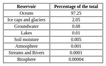
With reference to the water on the planet Earth, consider the following statements :

1. The amount of water in the rivers and lakes is more than the amount of groundwater.

2. The amount of water in polar ice caps and glaciers is more than the amount of groundwater.

Which of the statements given above is/are correct ?

Detailed Solution for UGC NET Paper 2 Geography Mock Test - 2 - Question 13

The correct answer is 2 only.

Key Points

  • Distribution of water on the surface of the earth:
  • Water in groundwater is 0.62% while in lakes and rivers it is 0.008 (Salt lakes)+0.009(freshwater lakes) + 0.0001(rivers)=0.0171. Hence, statement 1 is not correct.
  • Water in polar ice caps and glaciers is 2% while in groundwater it is 0.62%. Hence, statement 2 is correct.
UGC NET Paper 2 Geography Mock Test - 2 - Question 14

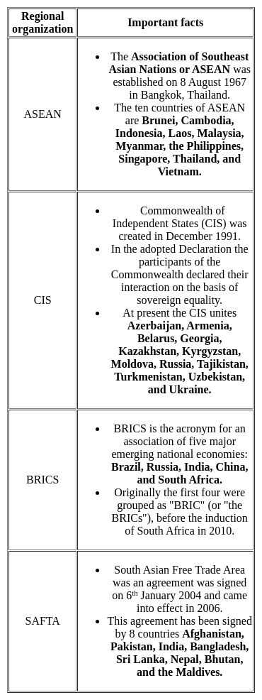
Match List-I with List-II and select the correct combination


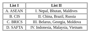
Choose the correct answer from the options given below:

Detailed Solution for UGC NET Paper 2 Geography Mock Test - 2 - Question 14
Key Points 


Hence, the correct matching is A - IV, B - III, C - II, D - I

UGC NET Paper 2 Geography Mock Test - 2 - Question 15
Till, Moraines and boulder clay are depositional land forms due to
Detailed Solution for UGC NET Paper 2 Geography Mock Test - 2 - Question 15

The Correct Answer is Glacial activity.

  • Till Moraines and boulder clay are depositional landforms that are formed due to Glacial activities.

Key Points

  • ​Boulder clay:
    • Boulder clay is a geological deposit of clay.
    • It is often full of boulders, which are formed out of the ground moraine material of glaciers and ice sheets.
    • Boulder clay is classed with a group of poorly sorted materials, described by the non-genetic term diamicton.
    • It was a typical deposit found in the Glacial Period.
    • Found in northern Europe and North America.
  • Moraine:
    • A moraine is an accumulation of unconsolidated debris (regolith and rock).
    • It is sometimes referred to as glacial till.
    • It occurs in both currently and formerly glaciated regions, and also which has been previously carried along by a glacier or ice sheet.
    • It may consist of partly rounded particles ranging in size from boulders to gravel and sand.
      • Sometimes called glacial flour.
    • Lateral moraines are those formed at the side of the ice flow, and terminal moraines were formed at the foot, marking the maximum advance of the glacier.
    • Other types of moraines include ground moraines and medial moraines.

​​​

UGC NET Paper 2 Geography Mock Test - 2 - Question 16
The accumulation of depression in a river channel or on a continental shelf that is potentially dangerous to ships is called:
Detailed Solution for UGC NET Paper 2 Geography Mock Test - 2 - Question 16

The correct answer is Shoal

Key Points

  • Shoal is the accumulation of sediment in a river channel or on a continental shelf that is potentially dangerous to ships.
  • Shoals appear as long and narrow ridges.
  • The landform occurs when an ocean current, stream, or river facilitates the deposition of granular material and sediment leading to localized shallowing of the water.
  • Shoals can form as fluvial landforms in lakes, rivers, and streams or as an ocean bank in the sea.
Additional Information

Coral Atoll :

  • An atoll is a ring-shaped coral reef, island, or series of islets.
  • An atoll surrounds a body of water called a lagoon.
  • Atolls develop with underwater volcanoes, called seamounts.

Coast :

  • Coast is also called shore and is a broad area of land that borders the sea.
  • The boundary of a coast, where land meets water, is called the coastline.
  • Because coasts are dynamic or constantly changing, they are important ecosystems.
  • They provide unique homes for marine plants, animals, and insects.
UGC NET Paper 2 Geography Mock Test - 2 - Question 17
______ is the largest slum in Asia.
Detailed Solution for UGC NET Paper 2 Geography Mock Test - 2 - Question 17

The correct answer is Dharavi

Key Points

  • Dharavi is a locality in Mumbai, Maharashtra, India, considered to be one of Asia's largest slums.
  • Dharavi has an area of just over 2.1 square kilometers and a population of about 1,000,000.
  • With a population density of over 277,136/km2, Dharavi is one of the most densely populated areas in the world.
  • The Dharavi slum was founded in 1884 during the British colonial era.
  • It grew because of the expulsion of factories and residents from the peninsular city center by the colonial government and from the migration of rural Indians into urban Mumbai.
  • For this reason, Dharavi is currently a highly diverse settlement religiously and ethnically.
  • Dharavi has an active informal economy in which numerous household enterprises employ many of the slum residents such as leather, textiles, and pottery products are among the goods made inside Dharavi.
  • Dharavi has suffered from many epidemics and other disasters, including a widespread plague in 1896 which killed over half of the population of Mumbai.
  • Sanitation in the slums remains poor.
UGC NET Paper 2 Geography Mock Test - 2 - Question 18
The term ‘Umland’ refers to:
Detailed Solution for UGC NET Paper 2 Geography Mock Test - 2 - Question 18

The correct answer is Area surrounding a town.
Key PointsUmland

  • In geography, "Umland" is a German term that refers to the surrounding countryside or hinterland of a town or city.
  • It includes the rural areas, suburbs, and small towns that are closely connected to the urban center in terms of economic, social, and cultural ties.
  • Umland is also used to describe the functional region that is influenced by the urban center, including the commuting zone and the trade area.
  • The concept of Umland is important in urban geography and regional planning because it reflects the spatial relationships and interdependencies between urban and rural areas.
  • The Umland provides resources, such as food, water, and energy, to the urban center, while the city provides jobs, services, and markets to the surrounding region.
  • The development of Umland can also affect the environment, as land use changes and urbanization alter the natural and agricultural landscapes.

Additional Information

  1. Heart of a town: This term refers to the central or downtown area of a town or city, often where the commercial and cultural activities are concentrated. The heart of a town is typically the oldest and most densely populated part of the urban center.

  2. Residential area of a town: This term refers to the parts of a town or city that are primarily used for housing. Residential areas can range from high-density apartment complexes to low-density suburban neighborhoods, depending on the size and structure of the town.

  3. Satellite town: This term refers to a town or city that is located near a larger urban center but is independent and self-sufficient in terms of its economy and services. Satellite towns are often built to accommodate the growing population and economic activities of the urban center, but also to provide an alternative living and working environment.

While these terms are related to the concept of a town or city, they refer to specific aspects of the urban or peri-urban landscape, whereas Umland refers more generally to the surrounding region that is closely connected to the town or city.

UGC NET Paper 2 Geography Mock Test - 2 - Question 19

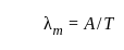
As the temperature of the black body increases,the dominant wavelength of the emitted radiation according to Wein's displacement law is:

Detailed Solution for UGC NET Paper 2 Geography Mock Test - 2 - Question 19

According to Wein's displacement law:

Where A = Wein’s constant =2.898 x 10⁻³ mk

T = Temperature of the body

So, as the temperature of the black body increases, the dominant wavelength of the emitted radiation shifts towards shorter wavelength.

UGC NET Paper 2 Geography Mock Test - 2 - Question 20

Consider the following statements about insolation and choose the correct option.

(A) Insolation is the incoming solar energy intercepted by the earth

(B) The amount and the intensity of the insolation vary during a day, in a second and in a year

(C) The amount of insolation increases from the equator towards the poles

Detailed Solution for UGC NET Paper 2 Geography Mock Test - 2 - Question 20

The correct answer is Only (A) and (B) are true.

Key Points: PointsThe question is about insolation, which is the incoming solar energy the Earth intercepts.

  • Option 1 is the correct answer, as statements (A) and (B) are true.
  • Statement (A) is true as insolation is the incoming solar energy the earth intercepts.
  • Statement (B) is also true as the amount and intensity of insolation vary during a day, in a second, and in a year.
  • These variations are due to factors such as the sun's angle, the atmosphere's thickness, and the earth's rotation and revolution.
  • Option 2 is incorrect as statement (A) is true, but statement (C) is false.
  • The amount of insolation actually decreases from the equator towards the poles.
  • Option 3 is incorrect as statement (B) is true, but statement (C) is false.
  • Option 4 is incorrect as all three statements are true, not false.

Additional Information

  • Insolation is an important factor that affects climate, weather, and ecosystems.
  • The variations in insolation can cause differences in temperature, pressure, wind, and precipitation patterns.
  • The equator receives more insolation than the poles because the sun's rays are more direct and spread over a smaller area.
  • The tilt of the earth's axis also affects the amount and distribution of insolation, leading to the seasons.
UGC NET Paper 2 Geography Mock Test - 2 - Question 21
The height of Tsunami’s wave depends upon _______.
Detailed Solution for UGC NET Paper 2 Geography Mock Test - 2 - Question 21

Explanation:

Tsunamis:

(i) Tsunamis, also known as seismic sea waves (mistakenly called “tidal waves”), are a series of enormous waves created by an underwater disturbance such as an earthquake, landslide, volcanic eruption, or meteorite. A tsunami can move hundreds of miles per hour in the open ocean and smash into land with waves as high as 100 feet or more.

(ii) From the area where the tsunami originates, waves travel outward in all directions. Once the wave approaches the shore, it builds in height. The topography of the coastline and the ocean floor will influence the size of the wave. There may be more than one wave and the succeeding one may be larger than the one before. That is why a small tsunami at one beach can be a giant wave a few miles away.

Additional InformationThe physics of a Tsunami:

(i) Tsunamis can have wavelengths ranging from 10 to 500 km and wave periods of up to an hour. As a result of their long wavelengths, tsunamis act as shallow-water waves.

(ii) A wave becomes a shallow-water wave when the wavelength is very large compared to the water depth. Shallow-water waves move at a speed, c, that is dependent upon the water depth and is given by the formula

c = √gH

where g is the acceleration due to gravity (= 9.8 m/s2) and H is the depth of water.

(ii) In the deep ocean, the typical water depth is around 4000 m, so a tsunami will therefore travel at around 200 m/s or more than 700 km/h.

UGC NET Paper 2 Geography Mock Test - 2 - Question 22
______ is an equatorial belt of low atmospheric pressure where the trade winds converge.
Detailed Solution for UGC NET Paper 2 Geography Mock Test - 2 - Question 22

The correct answer is Doldrums.

  • Doldrums is an equatorial belt of low atmospheric pressure where the trade winds converge.

Key Points

Moraine

  • Moraines are distinct ridges or mounds of debris that are directly laid down by a moving glacier. This material is usually soil and rock.
  • Moraines only show up in places that have, or used to have glaciers.
  • Glaciers are extremely large, moving rivers of ice.
  • Glaciers shape the landscape in a process called glaciation.
  • Glaciation can affect the land, rocks, and water in an area for thousands of years. That is why moraines are often very old.

La Nina

  • La Nina is a climate pattern that describes the cooling of surface ocean waters along the tropical west coast of South America.
  • La Nina is the counterpart of El Nino.
  • La Lina means Little Girl in Spanish.
  • La Lina occurs at irregular intervals of about two to seven years.
  • La Niña is caused by a build-up of cooler-than-normal waters in the tropical Pacific, the area of the Pacific Ocean between the Tropic of Cancer and the Tropic of Capricorn.
  • Unusually strong, eastward-moving trade winds and ocean currents bring this cold water to the surface, a process known as upwelling.

El Nino

  • El Nino is a climate pattern that describes the unusual warming of surface waters in the eastern tropical Pacific Ocean.
  • El Nino means Christ child or Littel Boy in Spanish
  • During the time of El Nino, the trade winds weaken and warm water pushed back east towards the coast of Latin American countries.
  • El Nino can affect our weather significantly and trade winds.
  • El Nino has a strong effect on marine life off the Pacific coast.

Additional Information

  • Atmospheric Pressure belts are seasonally identical horizontal pressure variations created in the earth's atmosphere just above the earth's surface due to seasonal and spatial variation of energy received by the earth at different places.
  • There are seven pressure belts on the earth's surface. They are the Equatorial Low, the two Subtropical highs, the two Subpolar lows, and the two Polar highs. Except for the Equatorial low, the others form matching pairs in the Northern and Southern Hemispheres.

Equatorial Low-Pressure Belts

  • It is located on either side of the North and South of the Equator in a zone extending from 0o to 5o.
  • It is thermally induced because of the intense heating of the ground by the vertical rays of the sun.
  • It represents the zone convergence of North-East and South-East trade winds. This convergence zone is characterized by light and feeble winds and because of the frequent calm conditions, this belt is also called a belt of calm or doldrums.

Subtropical High-Pressure Belts

  • It extends between 30o to 35o both the hemisphere
  • It is not thermally induced but dynamically induced as it owes its origin to the rotation of the earth and sinking and settling down of winds.
  • Here the zone convergence of winds at a higher altitude above this zone results in the subsidence of air from higher altitudes and this wind results in high pressure. This zone of high pressure is also called the Horse latitude.
  • The permanent winds blowing from the Sub-Polar High-Pressure to Sub-Polar Low-Pressure in both the hemisphere are called Westerlies.

Sub-Polar Low-Pressure Belts

  • It extends between 60o and 65o in both the hemisphere.
  • The low-pressure belt does not thermally induce because there is low temperature throughout the year and as such there should have been a high-pressure belt instead of low pressure.
  • Pressure gradient, rotation of the earth and Coriolis force, centrifugal action of wind are the factor that controls the air motion.
  • This region is marked by violent storms in winter.

Polar High-Pressure Belts

  • Polar high pressure is very small in area and extends between 70o to 90oin both the hemisphere.
  • The temperatures are always extremely low.
  • The Polar regions experience very cold climatic conditions due to the rays of the sun is extremely slanting.
  • These regions of Polar high-pressure belts are known as the Polar Highs.
  • These regions are characterized by permanent IceCaps.

UGC NET Paper 2 Geography Mock Test - 2 - Question 23

Given below are two statements, one is labelled as Assertion (A) and the other is labelled as Reason (R). Read the statements and choose the correct answer using the code given below.
Assertion (A) : Central Business District (CBD) of a city has high concentration of wholesale stores, offices and cultural and recreational activities.
Reason (R) : Prices and demand of real increases as distance towards CBD reduces.

Detailed Solution for UGC NET Paper 2 Geography Mock Test - 2 - Question 23

Key Points

Assertion (A): Central Business District (CBD) of a city has a high concentration of wholesale stores, offices, and cultural and recreational activities.

The concept of CBD:

  • The term Central Business District (CBD) is a widely used term in commercial real estate and is defined as the functional area of a city that has the maximum concentration of commercial, retail, and business centers.
  • Geographically, it coincides with the city center and is the focal point for the transportation networks of the city.
  • It has maximum urban density than other districts of the town and offers a healthy environment for carrying out various commercial activities.
  • Today, CBDs are a diverse region in metro cities that not only include retail spaces, commercial, offices, financial institutions, government centres, and medical centres, but also entertainment hubs, restaurants, hotels, and residential area

Hence, the assertion is correct.

Reason (R): Prices and demand of real increases as distance towards CBD reduces.

Price and demand relationship:

  • In ancient times, CBDs were the market squares where merchants and customers gathered to sell and buy things.
  • However, as cities evolved, land scarcity and increasing demand reduced horizontal expansions and gave way to vertical developments.
  • The relationship of land price and distance to CBD is significant and negative, which means indicating the decreasing of land price by increasing distance from the CBD.
  • Market price gives the same result as the appraised price which is the effect of distance on land values is significant and negative.

Hence, the reason is also correct.

Therefore, Both (A) and (R) are true and (R) is the correct explanation of (A).

UGC NET Paper 2 Geography Mock Test - 2 - Question 24

Consider the following pairs:

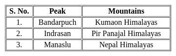
Which of the pairs given above are correct?

Detailed Solution for UGC NET Paper 2 Geography Mock Test - 2 - Question 24

The correct answer is 2 and 3 only.Key PointsBandarpuch Peak:

  • In the Indian state of Uttarakhand, there is a mountain range called Bandarpunch.
  • It is part of the Garhwal region of the Himalayas. Hence, pair 1 is incorrectly matched.
  • It is situated inside Govind Pashu Vihar National Park and Sanctuary and is a component of the Sankari Range.
  • It serves as a significant watershed for the Yamuna River's headwaters.
  • Of the four holiest pilgrimage sites (Chota Char Dham), Yamunotri is the westernmost.

Indrasan Peak:

  • It is situated on the Pir Panjal Range in the Kashmir region.
  • It is named after the Pir Panjal Pass.
  • Indrasan is the highest peak of the Pir Panjal Range. Hence, pair 2 is correctly matched.
  • Mount Indrasan is located at an altitude of 6221 meters above sea level.
  • It is one of the most difficult mountains to climb.
  • Deo Tibba and Indrasan are the major peaks of the Pir Panjal range.
  • The Kashmir valley lies between the Himadri and Pir Panchal ranges.

Manaslu Peak:

  • Manaslu (also known as Kutang) is the 8th highest mountain on earth.
  • This mountain is located in the Gorkha district of northwest Nepal. Hence, pair 3 is correctly matched.
UGC NET Paper 2 Geography Mock Test - 2 - Question 25
Critics of the Heartland Theory argue that:
(i) Technological advancements have reduced the strategic value of the "Heartland".
(ii) Controlling such a vast and diverse region is logistically impossible.
(iii) The theory is outdated and irrelevant to contemporary geopolitics.
Detailed Solution for UGC NET Paper 2 Geography Mock Test - 2 - Question 25

Answer; Option 3) Only (i) and (ii) are true.

The Heartland Theory, developed by Halford Mackinder in the early 20th century, has been influential in shaping geopolitical thought. It posits that the nation controlling the central Eurasian landmass could potentially dominate the globe. Despite its historical significance, the theory has faced various criticisms over the years, especially concerning technological advancements and the logistics of controlling such a vast region.

Key Points
Correct Criticisms:
Technological advancements have reduced the strategic value of the "Heartland"
  • Critics argue that with the advent of advanced technologies, especially in transportation and military capabilities (like air travel and missile technology), the geographical advantage theorized by Mackinder has diminished.
  • These advancements enable power projection over vast distances without the need for direct geographical control, thus undermining the Heartland's supposed invulnerability and strategic value.
Controlling such a vast and diverse region is logistically impossible
  • The Eurasian "Heartland" is incredibly vast, covering several countries with varied geographic, demographic, and socio-political landscapes.
  • Critics point out that effectively controlling this entire area, managing its resources, and integrating its diverse populations under a single strategic agenda is logistically unfeasible.
  • Such control would require immense resources and constant effort to maintain dominance and order, challenging the practicality of the Heartland Theory.
Additional Information
The theory is outdated and irrelevant to contemporary geopolitics:
  • While some critics argue that the Heartland Theory is outdated, saying it is entirely irrelevant might be an oversimplification.
  • Even though direct aspects of the theory may seem less applicable due to the reasons mentioned above, the importance of geography in strategic considerations still holds value.
  • Contemporary geopolitical strategies continue to be influenced by geographic factors, though in a more nuanced manner that accounts for technological, economic, and political developments.
  • Therefore, while the theory in its original form might face challenges of applicability, the fundamental idea that geography matters in international relations is still relevant.
UGC NET Paper 2 Geography Mock Test - 2 - Question 26
The Glacial feature which is mostly found in groups and collectively known as ‘basket of eggs topography’ is known as-
Detailed Solution for UGC NET Paper 2 Geography Mock Test - 2 - Question 26

Drumlins are depositional features of glaciers and are peculiar type of low round hillocks which resemble the shape of an inverted boat or half egg split lengthwise. This is the reason they are collectively known as basket of eggs topography. Drumlins are basically smooth, oval-shaped ridge like features composed of mainly glacial till with some masses of gravel and sand. The long axes of drumlins are parallel to the direction of ice movement.

UGC NET Paper 2 Geography Mock Test - 2 - Question 27
Read the following statements given below:

(a) Monsoon break is the phenomenon which means monsoon rainfall stops for a couple of days.

(b) Western Ghats receive orographic rain during the  monsoon.

(c) First rain in a place is called as monsoon burst.

(d) The El Nino current decreases the temperature of water.

Select the correct option:

Detailed Solution for UGC NET Paper 2 Geography Mock Test - 2 - Question 27

Western Ghats lie near the western coast of India. They occur as a hindrance for the winds of South-west monsoon winds and lead to orographic rain in the area. First occurrence of rain in an area is called as monsoon burst. During the Monsoon season, there are periods when there are sharp decrease in rainfall over most parts of the country, this is called monsoon break. The El Nino is a warm current and hence it leads to increase in temperatures by 3-4 degree Celsius.

UGC NET Paper 2 Geography Mock Test - 2 - Question 28
Area-Cost Curve Theory for industrial location was given by
Detailed Solution for UGC NET Paper 2 Geography Mock Test - 2 - Question 28

D. M. Smith gave theory of industrial location which was a combination of Weber’s and Losch’s Model. This theory is called as Area-Cost Curve theory. The theory has simplified world conditions. It states that the despite of lower revenue, entrepreneur is likely to choose a location which cost less.

UGC NET Paper 2 Geography Mock Test - 2 - Question 29

Which Soil is known as Black Cotton soil?

Detailed Solution for UGC NET Paper 2 Geography Mock Test - 2 - Question 29

Black soil is also known as 'regur' which is derived from a Telugu word 'reguda'. Black soil is also known as Black Cotton Soil as cotton is an important crop which is grown in this type of soil. These soil is rich in calcium carbonate, potash, lime and magnesium carbonate but has poor phosphorus content.

UGC NET Paper 2 Geography Mock Test - 2 - Question 30

Census data released on july 15,2011 reflects that 13.48 percent urban population lives in

Detailed Solution for UGC NET Paper 2 Geography Mock Test - 2 - Question 30

As per census 2011, Maharashtra has 13.48% of urban population. About 70% of population of India lives in rural areas. Goa & Mizoram are 1st in terms of being urban whereas Himachal Pradesh has 90% rural population, the most in India.

View more questions
92 docs|125 tests
Information about UGC NET Paper 2 Geography Mock Test - 2 Page
In this test you can find the Exam questions for UGC NET Paper 2 Geography Mock Test - 2 solved & explained in the simplest way possible. Besides giving Questions and answers for UGC NET Paper 2 Geography Mock Test - 2, EduRev gives you an ample number of Online tests for practice
Download as PDF