UGC NET Exam  >  UGC NET Tests  >  UGC NET Mock Test Series 2025  >  UGC NET Paper 2 Geography Mock Test - 9 - UGC NET MCQ

UGC NET Paper 2 Geography Mock Test - 9 - UGC NET MCQ


Test Description

30 Questions MCQ Test UGC NET Mock Test Series 2025 - UGC NET Paper 2 Geography Mock Test - 9

UGC NET Paper 2 Geography Mock Test - 9 for UGC NET 2025 is part of UGC NET Mock Test Series 2025 preparation. The UGC NET Paper 2 Geography Mock Test - 9 questions and answers have been prepared according to the UGC NET exam syllabus.The UGC NET Paper 2 Geography Mock Test - 9 MCQs are made for UGC NET 2025 Exam. Find important definitions, questions, notes, meanings, examples, exercises, MCQs and online tests for UGC NET Paper 2 Geography Mock Test - 9 below.
Solutions of UGC NET Paper 2 Geography Mock Test - 9 questions in English are available as part of our UGC NET Mock Test Series 2025 for UGC NET & UGC NET Paper 2 Geography Mock Test - 9 solutions in Hindi for UGC NET Mock Test Series 2025 course. Download more important topics, notes, lectures and mock test series for UGC NET Exam by signing up for free. Attempt UGC NET Paper 2 Geography Mock Test - 9 | 100 questions in 120 minutes | Mock test for UGC NET preparation | Free important questions MCQ to study UGC NET Mock Test Series 2025 for UGC NET Exam | Download free PDF with solutions
UGC NET Paper 2 Geography Mock Test - 9 - Question 1

Assertion (A): Mackinder’s theory of Heartland put forward a key formula “who rules Europe, commands the Heartland; who rules Heartland, commands the World Island; who rules the World Island command the world.”

Reason (R) : Mackinder’s formula offered Stalin’s strategy for territorial expansion and international supremacy.

Detailed Solution for UGC NET Paper 2 Geography Mock Test - 9 - Question 1

Both (A) and (R) are true and (R) is the correct explanation of (A).

Key Points

Assertion (A): Mackinder’s theory of Heartland put forward a key formula “who rules Europe, commands the Heartland; who rules Heartland, commands the World Island; who rules the World Island command the world.” is true because,

  • Sir Halford John Mackinder was a British geographer who wrote a paper in 1904 called "The Geographical Pivot of History."
  • Mackinder's paper suggested that the control of Eastern Europe was vital to control of the world. Mackinder postulated the following, which became known as the Heartland Theory: 
  • Who rules Eastern Europe commands the Heartland
    Who rules the Heartland commands the World Island
    Who rules the World Island commands the world.
  • Literally, the theory centers on the concept of a “pivot area/Heartland,” a sizeable region in Eurasia over which regional political control by a given country will in turn determine that country’s supremacy over world politics

Reason (R): Mackinder’s formula offered Stalin’s strategy for territorial expansion and international supremacy is also true

  • During World War II Stalin emerged, after an unpromising start, as the most successful of the supreme leaders thrown up by the belligerent nations.
  • In August 1939, after first attempting to form an anti-Hitler alliance with the Western powers, he concluded a pact with Hitler, which encouraged the German dictator to attack Poland and begin World War II.
  • Anxious to strengthen his western frontiers while his new but palpably treacherous German ally was still engaged in the West, Stalin annexed eastern Poland, Estonia, Latvia, Lithuania, and parts of Romania; he also attacked Finland and extorted territorial concessions by the influence of Mackinder theory.

​Therefore Both (A) and (R) are true and (R) is the correct explanation of (A).

UGC NET Paper 2 Geography Mock Test - 9 - Question 2

Assertion (A): Behavioural geography laid importance to human activity in space, place and environment by studying it at the level of the individual person.

Reason (R): Geographers in the Western societies discovered the utility of mental maps in understanding why spatial planning failed in most cases.

Select the correct answer from the codes given below :

Detailed Solution for UGC NET Paper 2 Geography Mock Test - 9 - Question 2

Correct Answer: ​(A) is true but (R) is false.

Key Points

Assertion (A): Behavioural geography laid importance to human activity in space, place and environment by studying it at the level of the individual person is true, because-

  • Behavioral geography is an approach to human geography that attempts to understand human activity in space, place, and environment by studying it at the disaggregated level of analysis at the level of the individual person. Behavioral geographers analyze data on the behavior of individual people, recognizing that individuals vary from each other.
  • The very emergence of the behavioral concept had taken place in 1951 when Kirk had used the term “Behavioural Environment” to explain some complicated socio-economic problems, but this work could not receive attention in the midst of the tornado of the Quantitative Revolution

Reason (R): Geographers in the Western societies discovered the utility of mental maps in understanding why spatial planning failed in most cases is wrong because,-

  • Mental or cognitive maps are psychological tools that we all use every day. As the name suggests, mental maps are maps of our environment that are stored in our brain. We rely on our mental maps to get from one place to another, to plan our daily activities, or to understand and situate events that we hear about from our friends, family, or on the news. Mental maps also reflect the amount and extent of geographic knowledge and spatial awareness that we possess. To illustrate this point, pretend that a friend is visiting you from out of town for the first time. Using a blank sheet of paper, take five to ten minutes to draw a map from memory of your hometown that will help your friend get around.
  • However, although all maps are artistic conceptions, a fundamental distinction may be drawn between maps proper – that is, those that are fixed cartographic manifestations of spatial relations – and mental maps, whose spatialization of meaning dwells latently in the minds of individuals or groups of people.
  • Visually realized maps can be analyzed to give insight into the underlying mental maps that have shaped them, laying bare mindsets or agendas that may be as socio-culturally significant as the geography they present. In addition, they may often contain prescriptive images that incidentally shape mental maps in those who view them, thus implanting or concretizing social knowledge. In this issue, Ute Schneider examines the development of German geographer Heinrich Schiffers’ mental maps with reference to cartographic illustrations in his books on Africa from the 1930s to the 1970s.
  • Mental Maps emerge as having successfully built on the spirit that propelled quantitative geography forward while also drawing away from the more mechanistic and positivist aspects of spatial analysis.  It harnessed an innovative methodology to a topic of geographical concern and visually expressed the results succinctly and elegantly.
  • The comparison reveals that the mental map is highly accurate spatial planning not failed in most cases. This finding contrasts with the spatial distortion characteristic of the classic mental map. Usually, our mental maps of places close to home are the most realistic.

​ Additional Information

  • The essence of the behavioral approach in geography lies in the fact that the way people behave is mediated by their understanding of the environment in which they live or by the environment itself with which they are confronted.
  • The behavioral approach has taken the view that a deeper understanding of man-environment interaction can be achieved by looking at the various psychological processes through which man comes to know the environment in which he lives and by examining the way in which these processes influence the nature of resultant behavior (i.e. perceptions of man, Downs concept, Mental Maps, etc) at the psychological level.
  • The behaviouristic approach is largely inductive aiming to build general statements out of observations of ongoing processes i.e. generalization achieved through specific cases.
UGC NET Paper 2 Geography Mock Test - 9 - Question 3

Consider the following statements:

1. Indian Mahogany species is well-known for its dense, redwood.

2. Mahogany can be found in almost every part of India.

3. Indian scientists discovered that the mahogany tree emits a sulphur compound that can help to reduce atmospheric warming caused by greenhouse gases.

4. Mahogany is considered a Mesophyte.

5. It is a fast-growing upright tree with an outwardly rounded symmetrical crown.

How many of the above statements are correct? 

Detailed Solution for UGC NET Paper 2 Geography Mock Test - 9 - Question 3

The correct answer is All five.

Key Points

Indian mahogany trees

  • It can grow to be 30-40 feet tall.
  • It is a fast-growing upright tree with an outwardly rounded symmetrical crown. Hence, Statement 5 is correct.
  • It has a spread of 20-30 feet.
  • The fruit is a large greenish-brown capsule that splits into five sections, each containing flat, long-winged, light brown seeds.
  • It is made of red-brown Indian-mahogany-trees wood. On the same plant, both male and female flowers are produced.
  • Mahogany is considered a Mesophyte. Hence, Statement 4 is correct.
  • The bark is smooth and dark brown. The leaves are pinnate and range in length from 12 to 25 cm, with four to eight leaflets.
  • The species is well-known for its dense, redwood. Hence, Statement 1 is correct.
  • Initially, the Spanish and English used mahogany to build ships. Then it was used in furniture.
  • The Spanish were the first to do this, but English workshops used it extensively in the 18th and early 19th centuries. This epoch is known as the "Age of Mahogany."
  • Other names for Indian Mahogany include Mahogany, West Indian Mahogany, Spanish mahogany, Madeira redwood, acajou, caoba, caoba de Santo, cheria mahogany, Cuban mahogany, American mahogany, True mahogany, small leaf mahogany, and Dominican mahogany.
  • Mahogany can be found in almost every part of India. It is also found in India's Thattekkad Wildlife Sanctuary, Kaziranga National Park, and Corbett National Park. Hence, Statement 2 is correct.
  • Indian scientists discovered that the mahogany tree emits a sulphur compound that can help to reduce atmospheric warming caused by greenhouse gases. Hence, Statement 3 is correct.
UGC NET Paper 2 Geography Mock Test - 9 - Question 4

Himalayan Yew is an important plant for medicinal plants found in various parts of Himachal Pradesh and Arunachal Pradesh. It has been characterized as endangered by IUCN due to

1. Depletion of an inter-species gene bank of Yew.

2. Threat of bio-piracy.

3. Soaking of groundwater in areas where it is present.

Detailed Solution for UGC NET Paper 2 Geography Mock Test - 9 - Question 4

The correct answer is None of the above.

Important Points

  • Yew has undergone a recent, range-wide population decline of at least 50% as per IUCN. 
  • Throughout its range in the western Himalayas, it is declining in response to a range of threats.
  • In Afghanistan, up to 50% of the forests where it occurs have been destroyed or heavily logged (UNEP 2003) over the last 30 years.
  • In northwest India and western Nepal, exploitation associated with Taxol production has led to a national decline of up to 90% in Taxus populations throughout the country.
  • Also, in other countries such as Pakistan, overexploitation for fuel, fodder, and medicinal use has led to a significant decline.
  • The decline is continuing and while the causes are largely understood, in many areas they will not be reversible. On this basis, an assessment of Endangered is warranted. So, options 1, 2 and 3 are NOT correct.
UGC NET Paper 2 Geography Mock Test - 9 - Question 5
Which one of the following statements correctly depicts the threshold according to Central Place Model ?
Detailed Solution for UGC NET Paper 2 Geography Mock Test - 9 - Question 5

Important PointsCentral place theory:

  • Central Place Theory is a spatial theory in urban geography and urban economics.
  • CPT explains the spatial arrangements, patterns, and distribution of urban areas and human settlements. 
  • Central place theory was given by Walter Christaller in 1933 on the basis of settlement patterns in southern Germany.
  • This study included analyzing the relationships between settlements of different sizes and related their economic activities (market) with the population. 
  • It is based upon the central place system and city size distribution.
  • Various geographers and urban planners study such theories and urban development models as a part of urban studies, regional science and hierarchical arrangement of human settlements.
Key Points

The theory then relied on two concepts: threshold and range.

  • The threshold is the minimum market size (population) needed to support a central place function (service).
  • The range is the maximum distance people are willing to travel to obtain a central place function (service).

There are three fundamental concepts

  • Concept of centrality: it means the importance of the central or focal point which offers goods and services to the complementary area
  • Complementary area: the area served by the central place
  • Concept of hierarchy: the arrangement of the settlement based on their number and size. Generally, there are seven or more levels in a meso-region. In India, there are six levels of settlements.

Hence, the threshold is the minimum number of people needed to support a service.

UGC NET Paper 2 Geography Mock Test - 9 - Question 6
Consider the following statements and choose which amongst them is true:

i. Sunspots are features on the solar surface which appears as dark spot

ii. Sunspots are huge magnetic storms that occur on sun’s surface.

Choose the correct options:

Detailed Solution for UGC NET Paper 2 Geography Mock Test - 9 - Question 6

Sunspots are the most conspicuous feature on the solar surface which appears as dark spots. The sunspots are simply the huge magnetic storms that occur on the sun’s surface. The number of sunspots increases and decreases in a cyclic manner.

Thus, the Correct answer is C.

UGC NET Paper 2 Geography Mock Test - 9 - Question 7
Consider the following statements:-

a) L.C . King’s theory is based on the arid topography as well as the semi-arid regions of South Africa.

b) He mentioned that the profile of an ideal hillslope must consist of summit, scarp, slope and pediments.

c) According to King, the African landscape consisted of scarps which have steep slopes and varied in angle from 15-30 degree.

d) He also did explain the presence of Yardangs and Zuegen as prime features of the African Landscape.

Which of the following options are correct?

Detailed Solution for UGC NET Paper 2 Geography Mock Test - 9 - Question 7

L.C. King never gave any explanation regarding the presence of Yardangs or Zuegen. King said that the African Landscape consists of three basic elements, such as Rock pediments with a concave slope, scarps with a steep slope and inselbergs which are steep residual hills that vary in size and shape.

UGC NET Paper 2 Geography Mock Test - 9 - Question 8
Which period in demographic history of India is known as the 'demographic divide'?
Detailed Solution for UGC NET Paper 2 Geography Mock Test - 9 - Question 8

The period of stagnant population or the year of 1921 is referred to as the demographic divide. During most of the 19th century India witnessed a slow growth of population which continued till the year 1921. The population was more or less stagnant, and the high birth rate was counterbalanced by high death rate. Large scale abnormal deaths were present in this period. The census year of 1921 witnessed only a negative growth rate of -0.31% which was observed only once in India.

UGC NET Paper 2 Geography Mock Test - 9 - Question 9

Consider the following statements:

1. Humans can depart from directions as indicated by the natural environment.

2. Vice man follows nature’s plan only if he is wise.

Which of the above statement(s) corresponds with Neo-Determinism?
Detailed Solution for UGC NET Paper 2 Geography Mock Test - 9 - Question 9

Neo-Determinism

  • Man is able to accelerate, slow, or stop the progress of a country’s regional development. But he should not, if he is wise, depart from directions as indicated by natural environment. He is like the traffic controller in a large city who alters the rate but not the direction of progress.
  • This theory is also called ‘’stop and go determinism’’.
  • It says that man follows nature’s plan only if he is wise, presuming he can act foolishly, which admits the possible contention that within broad limits set by the environment, man can choose at the very least. But wisdom and folly are human concepts. Nature knows nothing about them.
  • This theory says that in no environment are the possibilities limitless and for every choice a price must be paid. Man makes his choice and man himself judges its relative wisdom or folly by reference to goals he himself has established.
UGC NET Paper 2 Geography Mock Test - 9 - Question 10
_______________ are those that force the individual to move voluntarily.
Detailed Solution for UGC NET Paper 2 Geography Mock Test - 9 - Question 10

The correct answer is Push Factor

Key PointsPush Factor

  • Push factors force the individual to move voluntarily, and in many cases, they are forced because, the individual risk something if they stay.
  • Push factors may include conflict, drought, famine, or extreme religious activity.
  • Low economic activity and lack of job opportunities are also big push factors for migration. Other push factors include race and discriminating cultures, political intolerance, and persecution of people who question the status quo.
UGC NET Paper 2 Geography Mock Test - 9 - Question 11
Geographical transfer of culture traits by movements of people across space is which kind of diffusion-
Detailed Solution for UGC NET Paper 2 Geography Mock Test - 9 - Question 11

The correct answer is Relocative
Key Points

Relocative:

  • It is the geographical transfer of culture traits by movements of people across space.
  • As the location continuously changes, this type of diffusion is coined relocation diffusion.
  • An example is the movement of a bush fire, which has burned out at the origin but continues to spread at the periphery.
  • Immigration from country to country, city to city, etc.
  • As they relocate to a new location, they bring their ideas, cultural tradition such as food, music, and more.

Additional InformationCulture diffusion

  • Culture diffusion, also often called cultural diffusion or transcultural diffusion, is a term from anthropology, specifically cultural anthropology, a subfield that focuses on how cultures vary among the human population. Cultural diffusion describes the spread of one culture’s practices, beliefs, and/or items, like food, music, or tools.
  • Hierarchical Diffusion
  1. It is when an idea spreads by passing first among the most connected individuals, then spreading to other individuals.
  2. Think of the chain of command in businesses, and the government.
  3. There’s somewhat of a hierarchy in terms of position of authority.

Expansion Diffusion

  1. Expansion diffusion is the spread of a factor or an innovation from a centre with the concentration of things being diffused throughout the society.

Contagious Diffusion

  1. It is the expansion which affects all the individuals and areas uniformly from a source region.
  2. The introduction of a new fashion trend which spreads like a wildfire through various social media sites can be cited as an example.
UGC NET Paper 2 Geography Mock Test - 9 - Question 12
The theory that states “pieces of the Earth’s crust are in constant, slow motion driven by movement in the mantle” is called
Detailed Solution for UGC NET Paper 2 Geography Mock Test - 9 - Question 12

The correct answer is ​the theory of plate tectonics.

Key Points

  • The theory that states "pieces of the Earth's crust are in constant, slow motion driven by movement in the mantle" is called Plate Tectonics.
  • Plate tectonics is a scientific theory that explains the movement of the Earth's lithospheric plates, which make up the Earth's outer shell.
  • These plates float on the semi-fluid asthenosphere beneath them and are driven by the convective currents in the mantle.
  • This theory helps explain the formation of continents, ocean basins, earthquakes, volcanic activity, and the interactions of tectonic plate boundaries.

Additional Information

  • The theory of plate tectonics is a comprehensive scientific theory that explains the movement of the Earth's lithospheric plates, which make up the Earth's outer shell.
  • The theory is composed of several key ideas:
  • Lithospheric Plates: The Earth's rigid outer layer, known as the lithosphere, is divided into several large and small plates that "float" on the semi-fluid asthenosphere beneath them.
  • Plate Boundaries: The edges of these plates are the most dynamic regions on Earth. There are three primary types of plate boundaries:
    • Divergent Boundaries: At divergent boundaries, plates move away from each other. This can lead to the formation of new oceanic crust through seafloor spreading and the creation of rift valleys on continents.
    • Convergent Boundaries: At convergent boundaries, plates move toward each other. When two plates collide, it can result in subduction, where one plate is forced beneath the other, leading to the formation of deep ocean trenches, volcanic arcs, and mountain ranges.
    • Transform Boundaries: At transform boundaries, plates slide past each other horizontally. The friction and pressure along these boundaries can lead to earthquakes.
  • Seafloor Spreading: Harry Hess and Robert Dietz's work in the mid-20th century contributed to the understanding of seafloor spreading. This process occurs at mid-ocean ridges, where new oceanic crust is formed as magma rises and solidifies.
  • Plate Interactions: The interactions of these plates result in various geological features, including the formation of mountain ranges, volcanic activity, earthquakes, and the distribution of continents and oceans.
UGC NET Paper 2 Geography Mock Test - 9 - Question 13

What is the correct sequence of occurrence of various atmospheric layers from earth's surface?

1. Exosphere

2. Stratosphere

3. Troposphere

Choose the correct answer from the options given below

Detailed Solution for UGC NET Paper 2 Geography Mock Test - 9 - Question 13

The correct answer is 321.

Key Points

  • It envelops our world, keeps us warm, provides us with oxygen to breathe, and is the source of our weather.
  • The six layers that make up the Earth's atmosphere are troposphere, stratosphere, mesosphere, thermosphere, ionosphere, and exosphere.
  • The troposphere is our atmosphere's lowest layer. It rises from the ground to a height of around 10 kilometres above sea level.
  • The stratosphere is situated 50 kilometres above sea level.
  • The mesosphere is located above the stratosphere. It reaches a height of around 85 kilometres (53 miles) above our planet.
  • The exosphere is the outermost layer of the atmosphere.

Therefore, Troposphere⇒Stratosphere⇒Mesosphere

Additional Information

  • The ionosphere is not a discrete layer.
  • The ionosphere is a succession of zones in the mesosphere and thermosphere where high-energy solar radiation has thrown electrons lose from their parent atoms and molecules.
UGC NET Paper 2 Geography Mock Test - 9 - Question 14

Consider the following statements and choose the correct option.

(A) An economically developed country could be a densely populated country.

(B) More women in population's base necessarily indicates their better status in society.

(C) Population pyramid is a tool to study the population composition of a country.

Detailed Solution for UGC NET Paper 2 Geography Mock Test - 9 - Question 14

The correct answer is - Both (A) and (C) are correct.

Important Points

  • Statement (A) is correct:
    • Population density is the number of people living in a unit area of the earth’s surface.
    • How crowded a country is, has little to do with its level of economic development.
    • For example, both Bangladesh and Japan are very densely populated but Japan is far more economically developed than Bangladesh.
    • Hence, an economically developed country could be a densely populated country.
  • Statement (B) is not correct:
    • The number of women and men in a country is an important demographic characteristic.
    • The ratio between the number of women and men in the population is called the Sex Ratio.
    • The sex ratio is an important information about the status of women in a country.
    • In regions where gender discrimination is rampant, the sex ratio is bound to be unfavourable to women.
    • Such areas are those where the practice of female foeticide, female infanticide and domestic violence against women are prevalent.
    • One of the reasons could be lower socio-economic status of women in these areas.
    • However more women in the population's base does not mean they have a better status.
    • It could be that the men might have migrated to other areas for employment.
  • Statement (C) is correct:
    • Population composition refers to the structure of the population.
    • The composition of population helps us to know how many are males or females, which age group they belong to, how educated they are and what type of occupations they are employed in, what their income levels and health conditions are.
    • An important tool for studying the population composition of a country is by looking at the population pyramid.

Based on the above discussion, we can conclude that the correct statements are (A) and (C).

UGC NET Paper 2 Geography Mock Test - 9 - Question 15

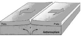
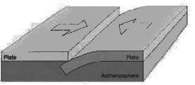
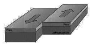
Consider the following statements regarding plate tectonics

1. Mid Ocean ridges and Rift Valley are characteristics of divergent plate boundaries

2. Convergent plate boundaries are constructive in nature.

3. San Andreas Fault is an example of Transform Plate boundary.

4. Zone of Subduction is associated with Divergent Plates.

Which of the is/are correct

Detailed Solution for UGC NET Paper 2 Geography Mock Test - 9 - Question 15

There are three ways in which the plates interact with each other

Divergent Plates:

  • Mid-ocean ridges are formed due to this kind of interaction. Here, the basaltic magma erupts and moves apart. On continents, East African Rift Valley is the most important geomorphological feature formed due to the divergence of African and Somali plates.
  • Divergent edges are sites of earth crust formation hence they are called as constructive edges, and volcanic earth forms are common along such edges.

Convergent Plate:

  • The zone of collision may undergo crumpling and folding, and folded mountains may emerge. Himalayan Boundary Fault is one such example.
  • When one of the plates is an oceanic plate, it gets embedded in the softer asthenosphere of the continental plate, and as a result, trenches are formed at the zone of subduction.
  • Near the convergent edge a part of the crust is destroyed, hence the name Destructive Edge

​Transform Plate:

  • In this kind of interaction, two plates slide past each other, and there is no creation or destruction of the landform but only deformation of the existing landform.
  • In oceans, transform faults are the planes of separation generally perpendicular to the mid-oceanic ridges. The San Andreas Fault along the western coast of the USA is the best example

UGC NET Paper 2 Geography Mock Test - 9 - Question 16

What is the wind direction in a cyclone in southern hemisphere ?

Detailed Solution for UGC NET Paper 2 Geography Mock Test - 9 - Question 16

The Correct Answer is clockwise

Key Points

  • Cyclones are rapid inward air circulation around a low-pressure area. The air circulates in an anticlockwise direction in the Northern hemisphere and clockwise in the Southern hemisphere.
  • The word Cyclone is derived from the Greek word Cyclos meaning the coils of a snake. It was coined by Henry Paddington because the tropical storms in the Bay of Bengal and the Arabian Sea appear like coiled serpents of the sea.
  • Cyclones are usually accompanied by violent storms and bad weather.

Additional Information

  • Cyclones
    • better known as depressions and are confined to temperate latitude.​
    • depressions vary from 150 to 2000 miles.
    • the wind blows inward into the low pressure in the center.
    • circulates in the anticlockwise direction in the northern hemisphere.
    • circulates in a clockwise direction in the southern hemisphere.
    • precipitation resulting in cyclonic air is due to the convergence of warm tropical air and cold polar air
  • There are 4 types of cyclones and they are:
    • Tropical cyclone.
    • Polar cyclone.
    • Mesocyclone.
    • Extratropical cyclone.
UGC NET Paper 2 Geography Mock Test - 9 - Question 17

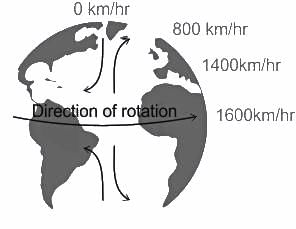
Select the correct option(s) for the statement from the codes given below:

A region is more diverse culturally if it:

(a) has homogeneous population composition

(b) has heterogeneous population composition.

(c) receives voluminous in migration.

(d) is geographically isolated.

Detailed Solution for UGC NET Paper 2 Geography Mock Test - 9 - Question 17

The correct answer is Only (b) and (c).

Key Points

  • Cultural diversity is the quality of diverse or different cultures, as opposed to monoculture, the global mono-culture, or a homogenization of cultures, akin to cultural decay.
  • The phrase cultural diversity can also refer to having different cultures respect each other's differences. The phrase "cultural diversity" is also sometimes used to mean the variety of human societies or cultures in a specific region, or the world as a whole.
  • This defined cultural diversity as "the set of distinctive spiritual, material, intellectual and emotional features of society or a social group", including lifestyles, value systems, traditions, and beliefs.
  • The world's population comprises people from different cultures, Therefore, in a culturally diversified society, society includes people from multiple cultures, and it has heterogeneous population composition. with each culture being a product of individual development.
  • Individual development refers to the historical development of the culture, the people involved, their social behavior, and how the population merged or moved to their current society.
  • The cultural diversity that accompanies migration enables new perspectives and experiences to be exchanged through intercultural encounters; it allows for creative and hybrid cultural practices to emerge; and it creates a general societal openness to difference and to change.

Additional Information

The world is naturally multicultural. Approaching cultural diversity with a mindset and actions that embrace this fact leads to many benefits, like

  • Compassion: Communication and understanding of differences lead to increased compassion instead of judgment.
  • Innovation: Varied perspectives and lenses of looking at the world lend to innovative thinking.
  • Productivity: People who come together and bring their style of working together tend to support a more productive team.
  • New Opportunities: Diversity opens the door to new opportunities and the blending of ideas that would otherwise have been homogeneous.
  • Problem-Solving: Challenges are layered, so having people with different backgrounds can lead to better problem-solving with a richness of opinions.
UGC NET Paper 2 Geography Mock Test - 9 - Question 18
In India, rigid and stable elevated lands, denuded rocks and series of scarps are the features of which of the following?
Detailed Solution for UGC NET Paper 2 Geography Mock Test - 9 - Question 18

The correct answer is the Peninsular plateau.

Key Points

  • Peninsular plateau
    • The land of India is characterized by great diversity in its physical features.
    • The north has a vast expanse of rugged topography consisting of a series of mountain ranges with varied peaks, beautiful valleys, and deep gorges.
    • The south consists of stable tableland with highly dissected plateaus, denuded rocks, and developed series of scarps. In between these two lies the vast north Indian plain. Hence, Option 2 is correct.
    • The Peninsular plateau is a tableland made up of crystalline, igneous, and metamorphic rocks. It was produced by the breakup and drifting of the Gondwana continent, making it the oldest landmass on the planet. Tors, block mountains, rift valleys, spurs, bare rocky formations, series of hummocky hills, and wall-like quartzite dykes are some of the region's key physiographic characteristics, which provide natural water storage sites.
    • It was developed as a result of the breakup and drifting of the Gondwana continent, making it one of the oldest landmasses.
    • The plateau has large and shallow valleys as well as rounded hills.
    • This plateau is divided into two sections: the Central Highlands and the Deccan Plateau.
    • The Central Highlands are the parts of the Peninsular plateau to the north of the Narmada river that cover a large portion of the Malwa plateau.
    • The general height of the plateau is from west to east, as seen by the direction of river flow.
    • This Peninsular plateau has seen recurring periods of uplift and submergence, which have been accompanied by crustal faulting and fractures.
    • The relief of the Peninsular plateau has become more diverse as a result of these spatial variations.

Additional Information

  • Northern mountains
    • The northern mountain complex contains the Himalayas, Trans Himalayas and Purvachal.
    • The Himalayas are in the north, Hindukush and Sulaiman are in the northwest and Purvachal in the east.
    • The Himalayas are true mountains. They are formed from the continent-continent plate collision. They have sediments of marine origin. It is not a single range but a series of ranges.
    • The Himalayas have three ranges namely the great Himalayas [Himadri], middle or lesser Himalayas [Himachal] and outer Himalayas [Shiwaliks].
  • Northern Plain
    • Youngest physiographic feature in India. Depositional flood plain created by Himalayan rivers like Indus, Ganga, Brahmaputra and Yamuna.
    • Densely populated with 30% of the world's population on 10% of the world's agricultural land.
  • Coastal plains
    • It extends from Rann of Kutch to Sunderbans.
    • It has two parts western coastal plain and the eastern coastal plain.
UGC NET Paper 2 Geography Mock Test - 9 - Question 19

Critics of the Malthusian Theory argue that advancements in which field have mitigated the challenges predicted by Malthus?

Detailed Solution for UGC NET Paper 2 Geography Mock Test - 9 - Question 19

Option 3) Agriculture and resource management

Critics of the Malthusian Theory contend that the challenges predicted by Reverend Thomas Robert Malthus in the late 18th century have been mitigated by significant advancements in agriculture and resource management. Malthus argued that the growing population would outstrip the capacity of the environment to provide sustenance, leading to inevitable checks on population growth.

Important Points

  • Advancements in agriculture have played a pivotal role in challenging Malthusian predictions.
  • Technological innovations, such as genetically modified crops, improved irrigation systems, and efficient farming practices, have substantially increased food production.
  • These developments have allowed societies to keep pace with, and in some cases exceed, the demands of a growing population.
  • Additionally, resource management strategies, including sustainable agricultural practices and conservation efforts, have contributed to a more efficient use of available resources.
  • Agriculture and resource management," is actually the correct answer. It aligns with the argument that improvements in these fields have alleviated the challenges anticipated by Malthus.
  • While this factor challenges Malthusian predictions, it is not the primary focus of critics when addressing the sustainability of resources
UGC NET Paper 2 Geography Mock Test - 9 - Question 20
Which one of the following continents has the maximum flow of global trade?
Detailed Solution for UGC NET Paper 2 Geography Mock Test - 9 - Question 20

The correct answer is Asia.

Key Points

  • Asia has a maximum flow of Global trade.
  • Global trade has been an ancient feature since early civilizations such as Indus Valley Civilization, Mesopotamia, etc.
  • In modern times technological advancements along with the industrial revolution led to a rapid boom in the volume of global trade.
  • Global trade, also known as international trade, is simply the import and export of goods and services across international boundaries.
  • Global trade can create economic wealth on a global scale as each country maximizes its revenue and growth by focusing on what it does best and saving money on imports that would be more costly for it to produce domestically.
  • Global trade can also reduce international conflict and war.
  • Global trade creates long-term mutually beneficial relationships.
  • The World Trade Organization (WTO) is a multilateral organization headquartered in Geneva, Switzerland.
  • It came into existence on January 1, 1995, as a successor to the General Agreement on Tariffs and Trade (GATT).
  • The organization functions as a central body that facilitates global trade.
UGC NET Paper 2 Geography Mock Test - 9 - Question 21
Which of the following is/are the need(s) of successful spatial analysis?
Detailed Solution for UGC NET Paper 2 Geography Mock Test - 9 - Question 21

The correct answer is option 4.

Concept:

Spatial data:

Spatial data is any kind of data that refers to a certain geographical region or place, either directly or indirectly. Spatial data, also known as geospatial data or geographic information, can quantitatively represent a physical item in a geographic coordinate system.

The spatial analysis consists of five key stages:

  • understanding your goal,
  • preparing data,
  • choosing suitable tools and techniques,
  • performing the research, and
  • estimating results.

Successful spatial analysis needs Appropriate software, Appropriate hardware and a Competent user.

Hence the correct answer is All options are correct.

UGC NET Paper 2 Geography Mock Test - 9 - Question 22
In a tropical cyclone the pattern of isobars is
Detailed Solution for UGC NET Paper 2 Geography Mock Test - 9 - Question 22

The centre of the tropical cyclone is characterized by extremely low pressure. Isobars are more or less circular but are less in number. This is the reason why winds quickly rush up towards the centre and attain gale velocity. The air pressure at the centre sometimes becomes as low as 650 mm.

UGC NET Paper 2 Geography Mock Test - 9 - Question 23
Which of the following arrangement is in correct sequence in the case of elements of slope profile?
Detailed Solution for UGC NET Paper 2 Geography Mock Test - 9 - Question 23

Most of the landforms have this type of arrangement. The Summital convexity is the topmost convex slope which supports waxing and the Basal concavity is the waning slope where the pediments or the weathered materials get deposited.

UGC NET Paper 2 Geography Mock Test - 9 - Question 24
Consider the following statements:-

a) Society is a mosaic of various modes of social processes and interactions.

b) Industrialization has always been a positive force in modernizing the society.

c) Competition as a social process has always been an universal action.

d) Accommodation goes hand in hand with cooperation and conflict.

Which of the following options are correct?

Detailed Solution for UGC NET Paper 2 Geography Mock Test - 9 - Question 24

Society is an expression of different social processes. Social processes, however, means those various modes of interactions between individuals or a number of groups which consist of cooperation, conflict, competition and assimilation. Competition is found in each society and in every class of society such as students, laborer’s, artists, etc. It enables the development of both the individuals and the nation.

Accommodation is what leads to social harmony. It is close to cooperation and conflict and thus must take trends in both the areas into consideration. It checks conflicts and enables all to work in close cooperation with each other.

UGC NET Paper 2 Geography Mock Test - 9 - Question 25
Over the last 100 years, the amount of CO2 in the atmosphere has increased by
Detailed Solution for UGC NET Paper 2 Geography Mock Test - 9 - Question 25

The amount of CO2 has been increasing rapidly since the 1970s. In the last 100 years, the amount of carbon-dioxide has increased by 30% from 270 ppm to 350 ppm. The increase of carbon dioxide leads to increase in surface temperature.

UGC NET Paper 2 Geography Mock Test - 9 - Question 26
Which of the following features provide major fishing grounds?
Detailed Solution for UGC NET Paper 2 Geography Mock Test - 9 - Question 26

The Continental Shelves are very significant ecologically as these provide ideal habitats for marine life including both plants and animals as well as micro-organisms. These in turn lead to ideal fishing grounds as they support the presence of the planktons and fishes. The coral reefs in the continental shelves promote all these factors. The shallow continental shelves also support the growth of rich mangroves.

UGC NET Paper 2 Geography Mock Test - 9 - Question 27

Match List-I with List-II

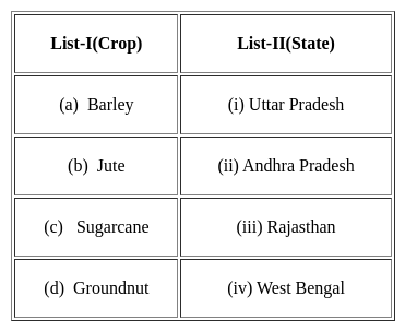
Select the correct answer from the options given below:

Detailed Solution for UGC NET Paper 2 Geography Mock Test - 9 - Question 27
  • The largest producer of Barley in the country is Rajasthan. It produces nearly 40% of the total production. Tonk, Sawai Madhopur, Bharatpur are major Barley producing region of the Rajasthan.
  • West Bengal is the largest producer of jute. It produces three-fourths of the total jute of the country and has two-third of the total area under jute production.
  • Uttar Pradesh is the largest producer of sugar cane In India. It accounts for 36% of the total production and has nearly 43% of the total area in sugar cane production.
  • Andhra Pradesh leads in the production of groundnut. It produces nearly 23%of the total production of India. Chitoor, Kunoor and Anantapur districts are the districts which have groundnut.
UGC NET Paper 2 Geography Mock Test - 9 - Question 28

Which of the following is not among the four coral reef regions of India identified by the Government for intensive conservation and management?

Detailed Solution for UGC NET Paper 2 Geography Mock Test - 9 - Question 28

The Gulf of Khambhat, also known as the Gulf of Cambay, is a bay on the Arabian Sea coast of India, bordering the state of Gujarat.

UGC NET Paper 2 Geography Mock Test - 9 - Question 29

Identify the non Green-House Gas(GHG) from the following :

Detailed Solution for UGC NET Paper 2 Geography Mock Test - 9 - Question 29

Carbon Monoxide is an odorless, tasteless, poisonous gas, CO, that results from the incomplete combustion of carbon. Inhalation causes central nervous system damage and asphyxiation. Carbon monoxide is a one-carbon compound in which the carbon is joined only to a single oxygen.

UGC NET Paper 2 Geography Mock Test - 9 - Question 30

…………….. clouds are associated with rainfall, thunder and lightning

Detailed Solution for UGC NET Paper 2 Geography Mock Test - 9 - Question 30

Towering cumulus, or cumulus congestus, may generate rain; they may also develop into the even larger, more energetic cumulonimbus. Cumulonimbus clouds, sometimes called "thunderheads," are associated with thunderstorms, lightning and intense, heavy rains as well as hail.

View more questions
92 docs|125 tests
Information about UGC NET Paper 2 Geography Mock Test - 9 Page
In this test you can find the Exam questions for UGC NET Paper 2 Geography Mock Test - 9 solved & explained in the simplest way possible. Besides giving Questions and answers for UGC NET Paper 2 Geography Mock Test - 9, EduRev gives you an ample number of Online tests for practice
Download as PDF