Geography: CUET Mock Test - 1 - CUET MCQ
30 Questions MCQ Test - Geography: CUET Mock Test - 1

Griffith Taylor introduced _____ in human geography.
What is the MAIN reason people move to cities in India?

Which of the following is NOT a challenge associated with rapid urbanisation in India
what is a KEY strategy for India to manage the challenges of urbanisation
Which of the following states in India has the highest percentage of its population living in urban areas
Which of the following waterways has been declared by the Government as the National Waterways N.W. No. 2?
How many national highways were merged to form National Highway 44 (NH 44)?
Which of the following statements is correct about " Haryana Roadways State Transport "?
- This body of the Government of Haryana was founded on 1st November 1960.
- The headquarters of this body is in Haryana.
Which mode of transport is considered the most economical for short distances?
What type of transport is commonly used for moving bulky goods over long distances within a country?
Assertion (A): Roads play a vital role in a nation’s trade and tourism.
Reason (R): Highways offer direct links and unobstructed routes for heavy vehicular movement, particularly for intercity travel.
Release of harmful substances in the air that can harm the health of humans, animals, and plants is called
Which one of the following is termed as middle path between the two ideas of environmental determinism and possibilism?
Consider the following statements regarding Population:
A. The way in which people are spread across the Earth's surface is known as the pattern of population distribution.
B. More than 90 % of the world’s population lives in about 10 % of the land surface.
C. The distribution of population in the world is extremely uneven.
Choose the correct option.
Which of the following statements is INCORRECT about migration in India?
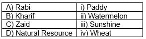
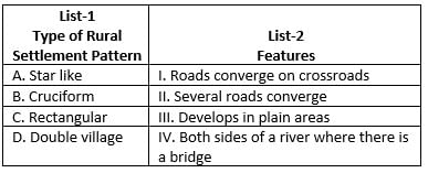
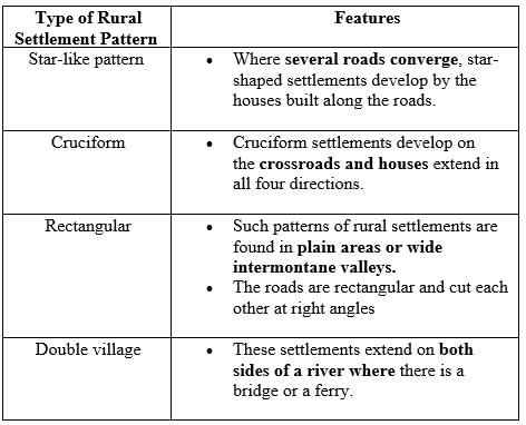
Match List I with List II
Choose the correct answer from the options given below:
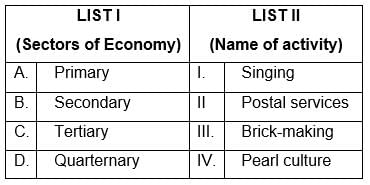
Match List I with List II
Choose the correct answer from the options given below:
Which of the following is NOT an example of human intervention causing soil erosion?
There are two statements given below, marked as Assertion (A) and Reason (R). Read the statements and choose the correct option.
Assertion (A): Soil erosion is increasing in India.
Reason (R): The causes of soil erosion differ from one place to another.
Important Questions for Geography: CUET Mock Test - 1
Geography: CUET Mock Test - 1 MCQs with Answers
Online Tests for Geography: CUET Mock Test - 1
|
© EduRev
|
Education Revolution
|


|


within 7 days!