Geography: CUET Mock Test - 8 - CUET MCQ
30 Questions MCQ Test - Geography: CUET Mock Test - 8

India accounts for about _____ percent of the world's surface area.

Through which of the following canal route, maximum international trade is taking place?
Which one of the following is the main cause of land degradation in Punjab?
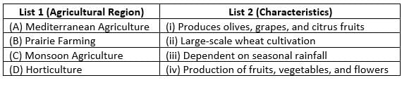
Match List I with List II
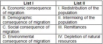
Choose the correct answer from the options given below:
Why is transport considered essential for economic activities?
Which mode of transport is best suited for carrying high-value goods over long distances?
What is the primary function of pipelines in transport?
What is the significance of the Golden Quadrilateral in India?
Which of the following is the longest railway route in the world?
Why is water transport considered the most economical for bulk goods?
Which waterway significantly reduces travel time between the Atlantic and Pacific Oceans?
Which of the following statements is true about water transport?
Which of the following is an important inland waterway in Europe?
How does the Mediterranean-Indian Ocean sea route benefit trade?
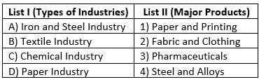
Match List-I with List-II :
Choose the correct answer from the options given below :
Match List-I with List-II :
Choose the correct answer from the options given below :
Match List-I with List-II :
Choose the correct answer from the options given below :
Match List-I with List-II :
Choose the correct answer from the options given below :
Which of the following statements are correct?
(A) Human Development focuses only on economic progress.
(B) The Welfare Approach of human development emphasizes government support for basic needs.
(C) The Capabilities Approach highlights the importance of expanding people's choices.
(D) The Income Approach considers national income as the only measure of development.
(E) Human Development is only measured at the global level.
Choose the correct answer from the options given below:
Which of the following statements are correct?
(A) A high Gross National Income (GNI) always leads to high human development.
(B) The Human Poverty Index (HPI) measures deprivation in health, education, and living standards.
(C) Gender Development Index (GDI) measures inequalities between men and women in human development.
(D) Countries with low HDI generally have higher literacy rates.
(E) Economic growth alone is sufficient for sustainable human development.
Choose the correct answer from the options given below:
Which of the following statements are correct?
(A) Countries with high HDI scores generally have strong education and healthcare systems.
(B) Developing countries have lower HDI rankings due to challenges in health, income, and education.
(C) Sustainable development focuses only on economic progress.
(D) Life expectancy is an indicator used to measure the standard of living.
(E) The concept of human development was introduced by Mahatma Gandhi.
Choose the correct answer from the options given below:
Which of the following statements are correct?
(A) The Human Development Index (HDI) is calculated based on health, education, and income.
(B) Countries with high HDI always have high per capita income.
(C) The Gender Inequality Index (GII) measures disparities between men and women.
(D) The Multidimensional Poverty Index (MPI) includes indicators beyond income to measure poverty.
(E) The HDI ranks countries from 0 to 10.
Choose the correct answer from the options given below
Which theory may be applied to characterise and forecast the demographics of any location?
Which of the following is inevitable in enlarging people's choice?
Which of the following statements is/are true in context of manganese and its production in India?
The process of migration from plain areas to pastures on mountains during summers and again from mountain pastures to plain areas during winters is known as:


Important Questions for Geography: CUET Mock Test - 8
Geography: CUET Mock Test - 8 MCQs with Answers
Online Tests for Geography: CUET Mock Test - 8
|
© EduRev
|
Education Revolution
|


|


