MAHA TET Exam  >  MAHA TET Tests  >  MH SET Mock Test Series 2025  >  MH SET Paper 2 Mock Test - 1 (Geography) - MAHA TET MCQ

MH SET Paper 2 Mock Test - 1 (Geography) - MAHA TET MCQ


Test Description

30 Questions MCQ Test MH SET Mock Test Series 2025 - MH SET Paper 2 Mock Test - 1 (Geography)

MH SET Paper 2 Mock Test - 1 (Geography) for MAHA TET 2025 is part of MH SET Mock Test Series 2025 preparation. The MH SET Paper 2 Mock Test - 1 (Geography) questions and answers have been prepared according to the MAHA TET exam syllabus.The MH SET Paper 2 Mock Test - 1 (Geography) MCQs are made for MAHA TET 2025 Exam. Find important definitions, questions, notes, meanings, examples, exercises, MCQs and online tests for MH SET Paper 2 Mock Test - 1 (Geography) below.
Solutions of MH SET Paper 2 Mock Test - 1 (Geography) questions in English are available as part of our MH SET Mock Test Series 2025 for MAHA TET & MH SET Paper 2 Mock Test - 1 (Geography) solutions in Hindi for MH SET Mock Test Series 2025 course. Download more important topics, notes, lectures and mock test series for MAHA TET Exam by signing up for free. Attempt MH SET Paper 2 Mock Test - 1 (Geography) | 100 questions in 120 minutes | Mock test for MAHA TET preparation | Free important questions MCQ to study MH SET Mock Test Series 2025 for MAHA TET Exam | Download free PDF with solutions
MH SET Paper 2 Mock Test - 1 (Geography) - Question 1

What is "Jhoom"?

Detailed Solution for MH SET Paper 2 Mock Test - 1 (Geography) - Question 1

The correct answer is A form of agriculture.

Key Points

  • "Jhoom" is a form of agriculture.
  • In this agriculture farming method, the trees and other vegetation that are present on a particular land are cut down to create the field for crop cultivation.
  • "Jhoom" is one of the oldest practices of agriculture systems.
  • Jhoom farming is also known as 'slash and burn agriculture or 'fire-fallow cultivation.
  • It is mostly practiced by the tribal groups in the northeastern states of India like Arunachal Pradesh, Meghalaya, Mizoram, and Nagaland and also in the districts of Bangladesh like Khagrachari and Sylhet.

Additional Information

MH SET Paper 2 Mock Test - 1 (Geography) - Question 2

The primary contributor to the increase in atmospheric carbon dioxide, a major greenhouse gas, is most likely due to:

Detailed Solution for MH SET Paper 2 Mock Test - 1 (Geography) - Question 2

Option 3) ​Burning of fossil fuels like coal, oil, and gas

Carbon dioxide is a major greenhouse gas that contributes to global warming. The primary contributor to the increase in atmospheric carbon dioxide is the burning of fossil fuels.

Key Points

Burning of fossil fuels like coal, oil, and gas

  • The burning of fossil fuels is the primary contributor to the increase in atmospheric carbon dioxide.
  • Fossil fuels release carbon dioxide when they are burned, and this carbon dioxide accumulates in the atmosphere.
  • The burning of fossil fuels has increased significantly over time, as the world's population has grown and economies have developed.

Additional Information

Increased volcanic eruptions

Volcanic eruptions can release carbon dioxide into the atmosphere, but they are not the primary contributor to the increase in atmospheric carbon dioxide. Volcanic eruptions release a relatively small amount of carbon dioxide compared to human activities, and the amount of carbon dioxide released by volcanoes has not increased significantly over time.

Deforestation and land use changes

Deforestation and land use changes can release carbon dioxide into the atmosphere, but they are not the primary contributor to the increase in atmospheric carbon dioxide. Deforestation and land use changes release carbon dioxide when forests are cleared and the land is used for other purposes, such as agriculture or development. However, the amount of carbon dioxide released by deforestation and land use changes has decreased over time, as the rate of deforestation has slowed.

Changes in oceanic currents

Changes in oceanic currents can affect the amount of carbon dioxide in the atmosphere, but they are not the primary contributor to the increase in atmospheric carbon dioxide. Changes in oceanic currents can cause carbon dioxide to be released from the ocean into the atmosphere, or they can cause carbon dioxide to be absorbed by the ocean from the atmosphere. However, the amount of carbon dioxide released or absorbed by the ocean due to changes in oceanic currents is relatively small compared to the amount of carbon dioxide released by human activities.

Hence, Option 3) ​Burning of fossil fuels like coal, oil, and gas is the correct option.

MH SET Paper 2 Mock Test - 1 (Geography) - Question 3

Which of the following type was not included in seven-fold system of land classification given by L.D. Stamp?

Detailed Solution for MH SET Paper 2 Mock Test - 1 (Geography) - Question 3

Correct Answer: Rural areas.

Key Points

  • In general, land use classification has two components, under The assessment of physical quality and the agricultural potential of the land. This is also known as ‘land capability’. The physical properties of land are almost unchangeable. In fact, the character and quality of land and its soil depend on the parent material, temperature, rainfall, water-retaining capacity, soil texture, soil structure, and humus contents. These properties of land do not change over a shorter period of time.
  • The assessment of land quality under the prevailing set of socioeconomic circumstances including farm structure, availability of irrigation, the relative cost of labor, capital inputs, level of technology, and price stability. The economic and social controls on production are more variable. A number of land use classification systems are in vogue in different countries of the world.
  • The first systematic land classification was done by L.D. Stamp.
  • In his land classification of Britain, Stamp adopted a seven-fold system, i.e. Arable, Heath and rough, Pastures, Orchards and nurseries, Meadowland, Forest and woodland, and Urban areas.
  • The details and justification of this classification in Stamp’s monumental work The Land of Britain: Its Use and Misuse. This classification helped in overcoming many of the problems pertaining to the demand of land after the Second World War.
  • Subsequently, Coleman, a student of Stamp, adopted a classification of 13 major classes with various subdivisions, making 70 land-use types in all. The International Geographical Union (IGU) resolved to produce a unified classification system for the whole world but in the absence of adequate and reliable data, particularly about developing countries, it could not become possible.

Additional Information

  • In India, M. Shafi is the pioneer of land use studies. He published the Land Use Survey in Eastern Uttar Pradesh in 1962. Under his supervision, over two dozen students completed their doctoral theses in the field of agricultural land use studies. The availability of satellite imageries has revolutionized the whole technique of land use classification. The main weakness of the traditional land use survey is that it gives only a static description of existing land use and is very time, effort and money consuming.
MH SET Paper 2 Mock Test - 1 (Geography) - Question 4

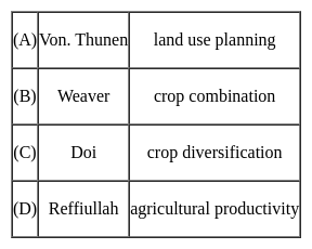
The following pairs are given about the contribution of geographer's in Agricultural geography and find out which is not correct?

Detailed Solution for MH SET Paper 2 Mock Test - 1 (Geography) - Question 4

The correct answer is D.

Key Points

  • Von Thunen conceived the idea of a land-use model in both urban and rural landscapes around a city on an isotropic landscape. His idea is basically how economic rent decreases from the center of a city to its periphery. His system of land use around a city with no trade alliance with any other country is ring-shaped.
  • In the field of agricultural geography, Weaver (1954) was the first to use statistical techniques for the demarcation of crop combination regions of the Middle West (USA). In his attempt to demarcate the agricultural regions of the Middle West (USA), Weaver based his analysis on acreage statistics.
  • Crop diversification refers to the addition of new crops or cropping systems to agricultural production on a particular farm taking into account the different returns from value-added crops with complementary marketing opportunities. Crop diversification is a concept that is opposite to crop specialization. Farmers all over the world, especially in developing countries, try to grow several crops in their holdings in an agricultural year. For the measurement of crop diversification, Doi and Bhatia (1965) developed a formula based on the gross cropped area.
  • There are several ways to measure crop diversification, and the most important include Herfindahl Index, Simpson Diversity Index, Ogive Index, Margalef Index, Shannon Index, Berger-Parker Index, and Entropy Index.
  • Jasbir Singh has proposed a unique method for the measurement of Agricultural Productivity which is in terms of monetary value earned from agriculture per capital-labor employed.
  • He proposed that agricultural productivity is the summation of the product of the output of production of the crop and its market price, from which the cost of production is subtracted. Agricultural Productivity= ∑( Pij*Mij)-Cop- Here P is output or production in quantity of the crop, M is the Market price and Cop is the cost of Production.
MH SET Paper 2 Mock Test - 1 (Geography) - Question 5

Match the List-I with List-II

Code:

Detailed Solution for MH SET Paper 2 Mock Test - 1 (Geography) - Question 5

The law of primate city was given by Mark Jefferson. The primate city is at least two times the size of the second city in terms of population. Examples of primate city include:-

  • Paris is the primate city of France. The population here is 9.6 million (201C. and the city of Marseilles has the population of 1.3 million.
  • In United Kingdom, London has population of 7 million and the second city, Birmingham has just the population of 1 million.
  • Bangkok, in Thailand has the population of 7.5 million and the second city, Nathaburi has population of mere 4,18,000.
  • Mexico City in Mexico has population of 8.6 million and the city if Guadalajara has population of 1.6 million.

Thus, the correct answer is C.

MH SET Paper 2 Mock Test - 1 (Geography) - Question 6
Match the scholars (List-I) with the book/theory/concept/model (List-II) they propounded.

Detailed Solution for MH SET Paper 2 Mock Test - 1 (Geography) - Question 6

Andre G. Frank is a German-American scholar who promoted the dependency theory by his famous work “the development of the underdevelopment”. In 1974, in his book ‘The Modern World System’, Wallerstein gave the world system theory. In his paper ‘The stages of Economic Growth’ in 1959, W.W. Rostow gave the modernization theory based on the historical stages of economic growth. John Friedmann has given the concept of core-periphery in his book “Regional Development policy: A case study of Venezuela” in the year 1966.

MH SET Paper 2 Mock Test - 1 (Geography) - Question 7

Arrange the following continents in descending order of size:

South America, Africa, Antarctica, Europe, North America

Choose the correct option.

Detailed Solution for MH SET Paper 2 Mock Test - 1 (Geography) - Question 7

The correct answer is Africa, North America, South America, Europe, Antarctica
Important Points

Africa:

  • Africa is the largest continent in terms of land area. It spans across 30.37 million square kilometers and is home to 54 recognized countries.
  • Some of the notable features of Africa include the Sahara Desert, the Nile River, and diverse wildlife in regions like the Serengeti and the Congo Basin.

North America:

  • North America is the second-largest continent in terms of land area.
  • It covers approximately 24.71 million square kilometers and includes countries such as the United States, Canada, Mexico, and several others.
  • Notable geographical features of North America include the Rocky Mountains, the Great Lakes, and the Grand Canyon.

South America:

  • South America is the third-largest continent, slightly smaller than North America.
  • It spans about 17.84 million square kilometers and includes countries like Brazil, Argentina, Peru, and many more.
  • South America is known for the Amazon Rainforest, the Andes Mountains, and iconic landmarks like Machu Picchu.

Antarctica:

  • Antarctica is the fourth-largest continent and the smallest among the five. It is located in the southernmost part of the Earth and is predominantly covered by ice.
  • Antarctica has a land area of about 14.0 million square kilometers, but most of it is covered by a thick ice sheet.
  • It is uninhabited permanently, except for some research stations, and serves as a unique scientific research site.

Europe:

  • Europe is the fifth-largest continent in terms of land area. It covers around 10.18 million square kilometers and includes countries like Germany, France, Italy, and others.
  • Europe is renowned for its rich history, diverse cultures, and famous landmarks such as the Eiffel Tower, the Colosseum, and the Acropolis.
MH SET Paper 2 Mock Test - 1 (Geography) - Question 8
India is the leading producer of which of the following crop?
Detailed Solution for MH SET Paper 2 Mock Test - 1 (Geography) - Question 8

 India ranks second in production of rice and wheat in world, after China. India holds third rank in world production of cotton. India has the largest area under Sesamum cultivation in world and is also the largest producer of the same, making for nearly one-third of the total produce of the oilseed in world.

Thus, the correct answer is C.

MH SET Paper 2 Mock Test - 1 (Geography) - Question 9

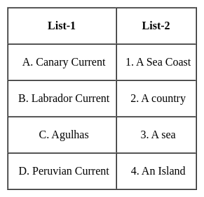
Match the following ocean currents with which they are named :


Select the correct code :

Detailed Solution for MH SET Paper 2 Mock Test - 1 (Geography) - Question 9

The correct answer is Option 4.
Important Point

  • Ocean currents
    • Ocean currents are like rivers flowing in oceans.
    • They represent a regular volume of water in a definite path and direction.
    • Ocean currents are influenced by two types of forces namely :
      • Primary forces that initiate the movement of water;
      • Secondary forces that influence the currents to flow
    • The primary forces that influence the currents are
      • Heating by solar energy 
        • Heating by solar energy causes the water to expand.
        • That is why near the equator the ocean water is about 8 cm higher in level than in the middle latitudes.
        • This causes a very slight gradient and water tends to flow down the slope.
      • Wind
        • Wind blowing on the surface of the ocean pushes the water to move.
        • Friction between the wind and the water surface affects the movement of the water body in its course.
      • Gravity
        • Gravity tends to pull the water down the pile and create gradient variation.
      • Coriolis force
        • The Coriolis force intervenes and causes the water to move to the right in the northern hemisphere and to the left in the southern hemisphere.
        • These large accumulations of water and the flow around them are called Gyres.
        • These produce large circular currents in all the ocean basins.
    • Major currents in the Pacific, Atlantic, and Indian oceans

Key Points

  • Effects of Ocean Currents
    • Ocean currents have a number of direct and indirect influences on human activities.
    • West coasts of the continents in tropical and subtropical latitudes (except close to the equator) are bordered by cool waters.
      • Their average temperatures are relatively low with narrow diurnal and annual ranges.
      • There is fog, but generally, the areas are arid.
    • West coasts of the continents in the middle and higher latitudes are bordered by warm waters which cause a distinct marine climate.
      • They are characterized by cool summers and relatively mild winters with a narrow annual range of temperatures.
    • Warm currents flow parallel to the east coasts of the continents in tropical and subtropical latitudes.
      • This results in warm and rainy climates.
      • These areas lie in the western margins of the subtropical anti-cyclones.
    • The mixing of warm and cold currents helps to replenish the oxygen and favor the growth of planktons, the primary food for the fish population.
      • The best fishing grounds of the world exist mainly in these mixing zones. 
MH SET Paper 2 Mock Test - 1 (Geography) - Question 10
Which of the following are evidences of Continent Drift Theory?
Detailed Solution for MH SET Paper 2 Mock Test - 1 (Geography) - Question 10

The correct answer is All of the Above.

Key Points

Evidence that supports the theory:

  • The Matching of Continents (Jig-Saw-Fit): 
    • The shorelines of Africa and South America facing each other match remarkably.
  • Rocks of Same Age Across the Oceans: 
    • Radiometric dating methods have correlated the rock formation in different continents.
  • Tillite: 
    • The glacial tillite found in the Gondwana system of sediments has its resemblance to six different landmasses of the Southern Hemisphere.
  • Placer Deposits: 
    • The placer deposits of gold in the Ghana coast do not have source rock in the region. 
    • The gold deposits of Ghana have been derived from the Brazil plateau when the two continents lay side by side
  • Distribution of Fossils: 
    • Identical species of plants and animals adapted to living on land or in freshwater are found on either side of the marine barriers.

Important Points

Continental Drift Theory:

  • Alfred Wegener put forward a continental drift theory in 1912.  
  • All the continents are formed of a single Continental mass and a mega ocean surrounded the same.
  • The supercontinent was named Pangaea and the Mega Ocean was called Panthalassa.  
  • Pangea first broke into two large Continental masses Laurasia and  Gondwanaland Forming the northern and Southern components respectively. 
  • Laurasia and Gondwanaland continued to break into smaller continents that existed today.  ​
MH SET Paper 2 Mock Test - 1 (Geography) - Question 11
Which of the following is NOT one of the three chief movements of ocean waters?
Detailed Solution for MH SET Paper 2 Mock Test - 1 (Geography) - Question 11

The correct answer is Water Current.Key Points

  • The 3 chief movements of ocean water are:
    • the waves,
    • the tides, and
    • the ocean currents.
  • Hence Water Current is NOT one of the three chief movements of ocean waters.
  • Oceans are a major part of the Hydrosphere.
  • They are all interconnected. The ocean waters are always moving.
  •  The five major oceans are the Pacific Ocean, the Atlantic Ocean, the Indian Ocean, the Southern Ocean, and the Arctic Ocean, in order of their size.

Additional Information

  • Ocean currents are the constant, predictable, directional movement of seawater driven by gravity, wind (the Coriolis effect), and the density of the water.
  • Ocean water moves in two directions: horizontally and vertically. 
  • Horizontal movements are referred to as currents, while vertical changes are referred to as upwellings or downwellings.
  • Ocean currents are one of the factors that affect the temperature of ocean water.
    • Warm ocean currents raise the temperature in cold areas.
    • Cold ocean currents decrease the temperature in warmer areas.
MH SET Paper 2 Mock Test - 1 (Geography) - Question 12
Which one of the following is correct for the cost-input graph of industrial production system, where point of profit maximising output is
Detailed Solution for MH SET Paper 2 Mock Test - 1 (Geography) - Question 12
Key Points

Cost-input graph of industrial production system:

  • In a cast input graph of industrial production, profit is maximized at the point at which an additional increment to output leaves profit unchanged.
  • The point at which marginal revenue equals marginal cost maximizes a company's profit.
  • The marginal cost of production measures the change in total cost of a good that arises from producing one additional unit of that good.
  • The marginal revenue is calculated by dividing the change in the total revenue by the change in the quantity.
  • From those input quantities and the price of inputs, the firm can determine the Total Cost of producing any level of output.
  • Total cost (TC) is the price of the inputs multiplied by the quantity of the inputs.

Hence, Marginal cost equals marginal revenue is correct for the cost-input graph of the industrial production system, where the point of profit-maximizing output.

MH SET Paper 2 Mock Test - 1 (Geography) - Question 13

As per the Census 2011, which state has the lowest population in India?

Detailed Solution for MH SET Paper 2 Mock Test - 1 (Geography) - Question 13

As per the Census of 2011 the population of Sikkim is 619,000 which is lowest in India. Sikkim is located at trijunction of India with China (Tibet), Nepal and Bhutan.

MH SET Paper 2 Mock Test - 1 (Geography) - Question 14
Consider the following statements and choose which amongst them is true:

i. Sunspots are features on the solar surface which appears as dark spot

ii. Sunspots are huge magnetic storms that occur on sun’s surface.

Choose the correct options:

Detailed Solution for MH SET Paper 2 Mock Test - 1 (Geography) - Question 14

Sunspots are the most conspicuous feature on the solar surface which appears as dark spots. The sunspots are simply the huge magnetic storms that occur on the sun’s surface. The number of sunspots increases and decreases in a cyclic manner.

Thus, the Correct answer is C.

MH SET Paper 2 Mock Test - 1 (Geography) - Question 15

Assertion A): The ecosystem surrounding a river gets damaged due to construction of a dam.

Reason R): The area gets inundated with large volume of water.

Choose the correct code:

Detailed Solution for MH SET Paper 2 Mock Test - 1 (Geography) - Question 15

Assertion and reasoning-type questions have one assertion (A) and one reason (R). We must first determine whether the statement is true. If the statement is true, we must next determine whether the reason correctly explains the assertion.

The example of a fish in a stream makes it quite clear that if we want to understand the living things and their place in nature properly, we must not consider them alone, but rather as a part of an interacting system. Such an interacting system, e.g., a stream is called ecosystem. You must have seen a lake, a pond; a grassland, or a forest at one time or another. All these are some more examples of the ecosystem.

While there are direct impacts on environment-related with the construction of the dam, for example, dust, erosion, borrow, and disposal problems. The greatest impacts result from the impoundment of water, flooding of land to form the dam, and alteration of water flow downstream. It affects the ecosystem as a whole.

The assertion is true.

Effects of dam:

  • Dams can displace a large number of people. .
  • Reservoirs behind a dam can lead to greenhouse gas emissions. ...
  • This technology hampers local ecosystems.
  • Some river sediment is useful
  • Dams create a risk of the flood if they experience a failure.
  • It provides water storage facility
  • The whole area gets overwhelmed with water
  • It helps farmers in irrigation
  • Electricity generation.

​The reason is true.

By referring to the above explanation we came to know that both the assertion and reason are true but Reason was not the correct explanation of the assertion.

MH SET Paper 2 Mock Test - 1 (Geography) - Question 16
Natural change and ______ are the two factors that affect population change for a particular area.
Detailed Solution for MH SET Paper 2 Mock Test - 1 (Geography) - Question 16

Three primary factors account for population change, or how much a population is increasing or decreasing. These factors are birth rate, death rate, and migration.

  • Births and deaths are natural causes of population change. The difference between the birth rate and the death rate of a country or place is called the natural increase. The natural increase is calculated by subtracting the death rate from the birth rate.

Key Points

  • Human migration involves the movement of people from one place to another with intention of settling, permanently or temporarily, at a new location.

Additional Information

  • Zero population growth refers to a population that is unchanging – it is neither growing nor declining; the growth rate is zero.
  • Immigration is the international movement of people to a destination country of which they are not natives or where they do not possess citizenship in order to settle as permanent residents or naturalized citizens.

Natural change and Migration are the two factors that affect population change for a particular area. Therefore Option 4 is the correct answer.

MH SET Paper 2 Mock Test - 1 (Geography) - Question 17
Adityapur Special Economic Zone (SEZ) is famous for :
Detailed Solution for MH SET Paper 2 Mock Test - 1 (Geography) - Question 17

Adityapur Special Economic Zone (SEZ) is famous for Automobiles and Auto components.

Key PointsAdityapur Special Economic Zone (SEZ):

  • Adityapur Special Economic Zone (SEZ) has become the first SEZ from Jharkhand and also the first from the automobile sector to be notified.
  • The 36-hectare automobiles and components SEZ has become the 23rd SEZ to be notified and will come up at Saraikela-Kharsawan district of Jharkhand, close to the Jamshedpur steel belt.
  • It would have backward and forward linkages with the domestic industry, especially with the steel sector.
  • The SEZ will be developed by Adityapur Industrial Area Development Authority, construction and engineering major Gammon India Ltd and Tata Steel subsidiary Jamshedpur Utility and Services Company(JUSCO).
  • This SEZ will also be the first from under-represented states like Jharkhand to be notified.

Hence, Automobile and Auto components will be the correct answer.

MH SET Paper 2 Mock Test - 1 (Geography) - Question 18

As the temperature of the black body increases,the dominant wavelength of the emitted radiation according to Wein's displacement law is:

Detailed Solution for MH SET Paper 2 Mock Test - 1 (Geography) - Question 18

According to Wein's displacement law:

Where A = Wein’s constant =2.898 x 10⁻³ mk

T = Temperature of the body

So, as the temperature of the black body increases, the dominant wavelength of the emitted radiation shifts towards shorter wavelength.

MH SET Paper 2 Mock Test - 1 (Geography) - Question 19
Which of the following statements is incorrect regarding endogenic processes inside the earth?
Detailed Solution for MH SET Paper 2 Mock Test - 1 (Geography) - Question 19

The correct answer is None of the above.

Key Points

  • The endogenic and exogenic forces can cause changes in the configuration of the surface of the earth and refer to as geomorphic processes. 
    • The energy originating from within the earth is the main force behind endogenic geomorphic processes.
    • This energy is mostly produced by rotational and tidal friction, radioactivity, and primordial heat from the origin of the earth.
    • This energy due to geothermal gradients and heat flow from within induces diastrophism and volcanism in the lithosphere.
  • The energy emanating from within the earth is the main force behind endogenic geomorphic processes.
  • The earth movements are mainly of two types: diastrophism and sudden movements
  • Diastrophism:
    • All processes that move, elevate or build up portions of the earth’s crust come under diastrophism. 
    • Diastrophism is further classified into orogenic (involving mountain buildings), epeirogenic (upliftment or warping of large parts of the earth's crust), earthquake, and plate tectonic activities.
  • Sudden movements:
    • They cause considerable deformation over a short span of time and may be of two types: earthquakes and volcanoes.
MH SET Paper 2 Mock Test - 1 (Geography) - Question 20
Visibility is reduced due to the presence of high levels of pollutants, especially in cold weather when water from the air also condenses. It is known as _____
Detailed Solution for MH SET Paper 2 Mock Test - 1 (Geography) - Question 20

The correct answer is Fog.

Key Points

  • The suspended particles can be undispersed carbon particles or substances called hydrocarbons.
    • The presence of high levels of all these pollutants leads to reduced visibility, especially in cold weather when water also condenses from the air.
    • This is known as smog and is a clear sign of air pollution.

Additional Information

  • Mist is a phenomenon caused by tiny droplets of water suspended in cold air, usually by condensation. Physically, this is an example of dispersion.
  • Smoke is a collection of airborne particles and gases that are emitted when a material undergoes combustion or pyrolysis, together with amounts of air that have entered or otherwise mixed into the mass.
  • Frost is a thin layer of ice on a solid surface formed by the contact of water vapor in the cold atmosphere above a solid surface with a temperature below the freezing point, and the resulting conversion of water vapor to ice as water.
MH SET Paper 2 Mock Test - 1 (Geography) - Question 21
Which one of the following factors of a boundary determination between the areas of two competing firms is correct, if the gradients of delivered price and freight rate of firms' production is same?
Detailed Solution for MH SET Paper 2 Mock Test - 1 (Geography) - Question 21

Important PointsDelivered price and freight rate of firms:

  • Freight Rate, the cost of transporting goods, is reflective of a number of factors aside from normal transportation costs.
  • The main determining factors of freight rate are: mode of transportation (truck, ship, train, aircraft), weight, size, distance, points of pickup and delivery, and the actual goods being shipped
  • The prime concern of all the theories of industrial location is to find the ‘optimal location’, which is economically the best and one that gives maximum profits.
  • There has been a change in factors that distinguish earlier theories from contemporary reality: decrease in the importance of transport costs; increased organizational dynamism, interdependence, and variety, and the rise of corporate enterprise.

When the gradients of delivered price and freight rate of firms' production are the same, only distance from the location of firms can determine the boundary between the areas of two competing firms.

MH SET Paper 2 Mock Test - 1 (Geography) - Question 22

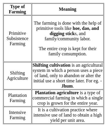
Which among the following is / are correct statements with respect to Shifting Cultivation as practiced in India?

  1. India’s largest area under shifting cultivation is in the state of Arunachal Pradesh
  2. In recent years, the cycle of shifting cultivation on a particular land has reduced drastically

Select the correct option from the codes given below:

Detailed Solution for MH SET Paper 2 Mock Test - 1 (Geography) - Question 22

The current practice of shifting cultivation in the eastern and north-eastern regions of India is an extravagant and unscientific form of land use. According to a recent estimate, India’s 0.59 percent of the total geographical area is under shifting cultivation. The effects of shifting cultivation are devastating and far-reaching in degrading the environment and ecology of these regions. The earlier 15–20 years cycle of shifting cultivation on a particular land has reduced to two or three years now. This has resulted in large-scale deforestation, soil and nutrient loss, and invasion by weeds and other species. The indigenous biodiversity has been affected to a large extent. The current statistics say that India’s largest area under shifting cultivation is in the state of Odisha.

MH SET Paper 2 Mock Test - 1 (Geography) - Question 23

A highest point in a wave is its

Detailed Solution for MH SET Paper 2 Mock Test - 1 (Geography) - Question 23

A crest is the highest point the medium rises to and a trough is the lowest point the medium sinks to. A crest is a point on the wave where the displacement of the medium is at a maximum. A point on the wave is a trough if the displacement of the medium at that point is at a minimum.

MH SET Paper 2 Mock Test - 1 (Geography) - Question 24

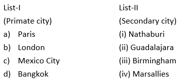
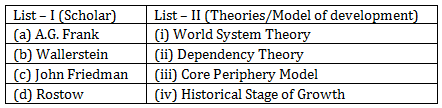
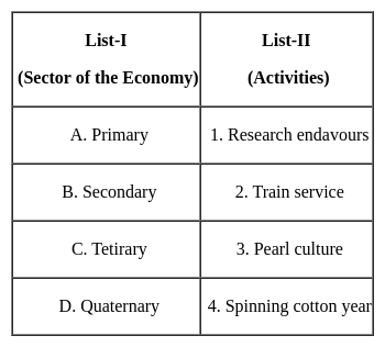
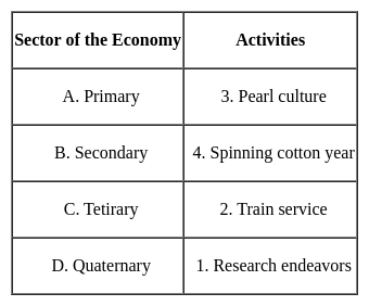
Match the List - I with List - II and select the correct answer from the code given below :

Detailed Solution for MH SET Paper 2 Mock Test - 1 (Geography) - Question 24
Key Points 

Hence, the correct matching is A - 3, B - 4, C - 2, D - 1

Important PointsActivities that generate income are termed economic activities. On the basis of economic activities, the Indian economy can be divided into 3 major sectors that are the primary sector, the secondary sector, and the tertiary sector. There are two other sectors also, called quaternary and quinary activity.

MH SET Paper 2 Mock Test - 1 (Geography) - Question 25

Polavaram Project is located in which state?

Detailed Solution for MH SET Paper 2 Mock Test - 1 (Geography) - Question 25

Andhra Pradesh of Godavari Waters to Krishna Basin. The Project is located in Andhra Pradesh near Polavaram village about 34 KMs.

Thus, the correct answer is C.

MH SET Paper 2 Mock Test - 1 (Geography) - Question 26
Which one of the following is the largest linguistic group of India?
Detailed Solution for MH SET Paper 2 Mock Test - 1 (Geography) - Question 26

The correct answer is Indo-Aryan.

Key Points

  • As per the Linguistic survey report of the 2011 census,
  • Hence. option 3 is correct.
MH SET Paper 2 Mock Test - 1 (Geography) - Question 27

Which of the following statement is not correct about andesitic or acidic lava?

Detailed Solution for MH SET Paper 2 Mock Test - 1 (Geography) - Question 27

The correct answer is They are dark coloured basalt, rich in iron and magnesium but poor in silica

Important Points

  • ACIDIC: Magma is composed of molten rock and is stored in the Earth’s crust. Lava is magma that reaches the surface through a volcano vent.
    • These lavas are highly viscous with a high melting point.
    • They are light-colored, of low density, and have a high percentage of silica.
    • They flow slowly and seldom travel far before solidifying.
    • The resultant volcanic cone is therefore stratified (hence the name stratovolcano) and steep-sided.
    • Andesitic lava flow occurs mostly along the destructive boundaries (convergent boundaries).
  • BASIC: These are the hottest lavas, about 1,000 °C, and are highly fluid.
    • They are dark coloured basalt, rich in iron and magnesium but poor in silica.
    • They flow out of volcanic vent quietly and are not very explosive.
    • Due to their high fluidity, they flow readily with a speed of 10 to 30 miles per hour.
    • They affect extensive areas, spreading out as thin sheets over great distances before they solidify.
    • The resultant volcano is gently sloping with a wide diameter and forms a flattened shield or dome.
    • Shield type lava flow is common along the constructive boundaries (divergent boundary).
MH SET Paper 2 Mock Test - 1 (Geography) - Question 28
Which state has the largest tribal population according to the census of 2011?
Detailed Solution for MH SET Paper 2 Mock Test - 1 (Geography) - Question 28

 The state of Madhya Pradesh has tribal population of 1,53,16,784. This number is nearly 21.1% of the total population of the state. The tribes here include Gond, Mina, Oraon, Munda, Kol, Kawar, Korku, Habla, Saharia tribes among others. The states of Mahrashtra, Meghalaya and Mizoram have tribal population of 10510213, 2555861 and 1036115 respectively.

Thus, the correct answer is C.

MH SET Paper 2 Mock Test - 1 (Geography) - Question 29
Which of the following model is an example of spatial interaction?
Detailed Solution for MH SET Paper 2 Mock Test - 1 (Geography) - Question 29

Spatial interaction models aim to explain the flow of people, resources or ideas from one geographical space to another. The gravity model is a type of models based on Sir Isaac Newton’s low of gravitation. It can show trade, migration, between two cities. The gravity model is thus an example of spatial interaction.

MH SET Paper 2 Mock Test - 1 (Geography) - Question 30
What do large scale maps show?
Detailed Solution for MH SET Paper 2 Mock Test - 1 (Geography) - Question 30

The correct answer is Villages and town localities.
Important Points

Large scale maps show a relatively small area with a great amount of detail. They are typically used in topographic, cadastral, city planning, and detailed engineering surveys. Therefore, among the options provided:

  1. Villages and town localities are typically shown in large scale maps, as these maps can display detailed features of a small area.

The other options:

  1. States and countries
  2. Continents and oceans
  3. Climatic regions of the world

are typically shown in small scale maps, which cover a large area with less detail.

So, the correct answer is:

  1. Villages and town localitie
View more questions
60 tests
Information about MH SET Paper 2 Mock Test - 1 (Geography) Page
In this test you can find the Exam questions for MH SET Paper 2 Mock Test - 1 (Geography) solved & explained in the simplest way possible. Besides giving Questions and answers for MH SET Paper 2 Mock Test - 1 (Geography), EduRev gives you an ample number of Online tests for practice
Download as PDF