MAHA TET Exam  >  MAHA TET Tests  >  MH SET Mock Test Series 2025  >  MH SET Paper 2 Mock Test - 10 (Geography) - MAHA TET MCQ

MH SET Paper 2 Mock Test - 10 (Geography) - MAHA TET MCQ


Test Description

30 Questions MCQ Test MH SET Mock Test Series 2025 - MH SET Paper 2 Mock Test - 10 (Geography)

MH SET Paper 2 Mock Test - 10 (Geography) for MAHA TET 2025 is part of MH SET Mock Test Series 2025 preparation. The MH SET Paper 2 Mock Test - 10 (Geography) questions and answers have been prepared according to the MAHA TET exam syllabus.The MH SET Paper 2 Mock Test - 10 (Geography) MCQs are made for MAHA TET 2025 Exam. Find important definitions, questions, notes, meanings, examples, exercises, MCQs and online tests for MH SET Paper 2 Mock Test - 10 (Geography) below.
Solutions of MH SET Paper 2 Mock Test - 10 (Geography) questions in English are available as part of our MH SET Mock Test Series 2025 for MAHA TET & MH SET Paper 2 Mock Test - 10 (Geography) solutions in Hindi for MH SET Mock Test Series 2025 course. Download more important topics, notes, lectures and mock test series for MAHA TET Exam by signing up for free. Attempt MH SET Paper 2 Mock Test - 10 (Geography) | 100 questions in 120 minutes | Mock test for MAHA TET preparation | Free important questions MCQ to study MH SET Mock Test Series 2025 for MAHA TET Exam | Download free PDF with solutions
MH SET Paper 2 Mock Test - 10 (Geography) - Question 1

Considering the insolation received in 100, which of the following statements is/are correct regarding the heat budget of the Earth?

1. Around 35 units are reflected back before reaching the surface of the Earth.

2. 65 units are absorbed by the atmosphere and the Earth’s surface.

3. The earth radiates back 51 units as terrestrial radiation.

Select the correct answer from the options given below.

Detailed Solution for MH SET Paper 2 Mock Test - 10 (Geography) - Question 1
  • The earth as a whole does not accumulate or lose heat. It maintains its temperature.
  • This can happen only if the amount of heat received in the form of insolation equals the amount lost by the earth through terrestrial radiation.
  • Consider that the insolation received at the top of the atmosphere is 100 percent.
  • While passing through the atmosphere some amount of energy is reflected, scattered and absorbed. Only the remaining part reaches the earth surface.
  • Roughly 35 units are reflected back to space even before reaching the earth’s surface. Of these, 27 units are reflected back from the top of the clouds and 2 units from the snow and ice-covered areas of the earth. The reflected amount of radiation is called the albedo of the earth.
  • The remaining 65 units are absorbed, 14 units within the atmosphere and 51 units by the earth’s surface.
  • The earth radiates back 51 units in the form of terrestrial radiation. Of these, 17 units are radiated to space directly and the remaining 34 units are absorbed by the atmosphere (6 units absorbed directly by the atmosphere, 9 units through convection and turbulence and 19 units through latent heat of condensation).
  • 48 units absorbed by the atmosphere (14 units from insolation +34 units from terrestrial radiation) are also radiated back into space.
  • Thus, the total radiation returning from the earth and the atmosphere respectively is 17 + 48 = 65 units which balance the total of 65 units received from the sun.
  • This is termed the heat budget or heat balance of the earth.
  • This explains why the earth neither warms up nor cools down despite the huge transfer of heat.
MH SET Paper 2 Mock Test - 10 (Geography) - Question 2

According to the Central Place Theory, the Transport Principle can express as

Detailed Solution for MH SET Paper 2 Mock Test - 10 (Geography) - Question 2

Walter Christaller, in his Central Place Theory gave three principles for proper arrangement and hierarchy. The Transport Principle is the scenario that denotes efficient transport network. It involves the connection of all central places in hierarchical order. The transport principle is given by k=4.

Thus, the correct answer is B.

MH SET Paper 2 Mock Test - 10 (Geography) - Question 3

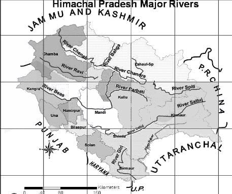
Through which state do the rivers Chenab, Ravi, Beas, Sutlej and Yamuna flow?

Detailed Solution for MH SET Paper 2 Mock Test - 10 (Geography) - Question 3

The correct answer is Himachal Pradesh.

 Key Points

  • Rivers in Himachal Pradesh:
    • The perennial rivers found in the Indian state of Himachal Pradesh are Beas, Chenab, Ravi, Satluj, and Yamuna.
    • Beas river arises from the Pir Panjal range near the Rohtang pass.
      • It covers a distance of approx. 256 km in the state.
      • The tributaries of the river Beas are Parbati, Hurla, Sainj, Uhl, Suheti, Luni, Banganga, and Chaki.
    • Chenab is the largest river formed by the two streams named Chandra and Bhaga.
      • These two meet at Tandi in Lahaul (Lahaul and Spiti district).
      • It flows for a distance of approx. 122 km in the state.
    • Ravi river rises from Bara Banghal of Kangara district, Himachal Pradesh.
      • The river covers a distance of approx. 158 km.
    • Satluj river originates from Tibet, crosses the Indo-Tibetan border, and joined by the Spiti river.
      • The river emerges from the mountains at the Bhakra and has a catchment area of about 20,000 sq km. in Himachal Pradesh.
    • Yamuna river originates from Yamunotri in the Uttarkashi district of Uttarakhand.
      • The tributaries of the river are Tons, Giri, and Bata, and the catchment area of about 2,320 sq km.

Additional Information 

  • ​Beas river has a total length of 470 km and is home to the Indus dolphin.
    • The river passes through Himachal Pradesh, Punjab, and Pakistan. As per the Indus Water Treaty, the water of the river Beas is allocated to India.
  • The river Chenab flows through Himachal Pradesh, Punjab, Jammu and Kashmir, and Pakistan. 
    • As per the Indus Water Treaty, the water of the river Chenab is allocated to Pakistan.
    • The major dams found on the river are the Salal Dam, Pakal Dul Dam, etc.
  • The river Ravi flows through the Indian states of Punjab, Himachal Pradesh, Jammu and Kashmir, and Rajasthan.
    • It also flows through Pakistan. As per the Indus Water Treaty, the water of the river Ravi is allocated to India.
    • The Ranjit Sagar Dam is built on the Ravi river.
  • The river Satluj is the longest of the five river systems of Punjab.
    • The river passes through three countries viz China, India, and Pakistan. 
    • As per the Indus Water Treaty, the water of the river Satluj is allocated to both India and Pakistan.
    • Bhakra Nangal Dam, Karcham Wangtoo Hydroelectric Plant, Nathpa Jhakri Dam are built on the river Satluj.
  • The Yamuna river the longest and the second-largest tributary of the river Ganga.
    • The river has a total length of approx. 1,376 km.
    • The river flows through states like Uttarakhand, Himachal Pradesh, Haryana, Delhi, and Uttar Pradesh.
    • Important tributaries of the river are Tons, Hindon, Ken, Chambal, Sindh, Sasur Khaderi, and Betwa.​​

MH SET Paper 2 Mock Test - 10 (Geography) - Question 4

Given below are two statements, one labelled as assertion(A) and other labelled as reason(R).

Assertion(A)- Aerial photographs are more useful when spatial detail is more critical than spectral information.

Reason(R)- Aerial photograph’s spectral resolution is generally coarse.

Detailed Solution for MH SET Paper 2 Mock Test - 10 (Geography) - Question 4

Aerial photographs are most useful when fine spatial detail s more critical than spectral information, as their spectral resolution is generally coarse when compared to data captured with electronic sensing devices. The geometry of vertical devices is well understood and it is possible to make very accurate measurements from them.

MH SET Paper 2 Mock Test - 10 (Geography) - Question 5
Given below are the two statements, one labelled as Assertion (A) and the other labelled as Reason (R). Select your answer from the code given below:

Assertion (A)- All living things have intrinsic value.

Reason (R) - Diversity of life forms contribute to the realization of these values .

Detailed Solution for MH SET Paper 2 Mock Test - 10 (Geography) - Question 5

Deep ecology is an environmental philosophy promoting the worth of human beings. It states that the environment is a balance of complex interrelationship where the existence of organism is dependent on the existence of others within ecosystem. Thus, overuse and over utilization and destruction of environment not only disturbs the environment but also the other organisms in the ecosystem.

Thus, the Correct answer is A.

MH SET Paper 2 Mock Test - 10 (Geography) - Question 6
Trough and ridge are
Detailed Solution for MH SET Paper 2 Mock Test - 10 (Geography) - Question 6

The correct answer is option 1.

  • A trough is an elongated area of relatively low pressure extending from the centre of a region of low pressure.
  • A ridge is an elongated area of relatively high pressure extending from the centre of a high-pressure region.

Key Points

  • Troughs and ridges are pressure field qualities that can be noticed on a weather map.
  • Troughs are found in low-pressure locations, whereas ridges are found in high-pressure areas.
  • Troughs are elongated areas of low pressure that generally occur before a cold front. A trough is sometimes a sign of impending clouds, precipitation, or a change in wind direction.
  • Ridges are extended areas of relatively high pressure in the weather. As a result, the area around them becomes dry. They can also bring onshore breezes, which can cause coastal rains.
  • Troughs are notorious for providing cool, cloudy weather, whereas ridges typically offer warmer, drier weather. This phenomenon occurs when the air in a high-pressure area or ridge compresses and warms as it falls. When this happens, cloud production is slowed, therefore sunny skies are more frequent in high-pressure areas. When it comes to low-pressure areas, the opposite is true.

MH SET Paper 2 Mock Test - 10 (Geography) - Question 7
Which fault line is the most active fault line in Himalaya system?
Detailed Solution for MH SET Paper 2 Mock Test - 10 (Geography) - Question 7

 The Main Central Thrust (MCT) lies between Greater Himalayas and Lesser Himalayas. Many earthquakes have occurred along this fault line. Some of these include earthquakes at Srinagar in 2005, Kandla in 1905, Uttarkashi in 1993 and Kathmandu in 2015. It is the most active fault line in Himalayan mountain system.

Thus, the correct answer is A.

MH SET Paper 2 Mock Test - 10 (Geography) - Question 8

Given below are two statements. One is labelled as Assertion (A) and the other is labelled as Reason (R).

Assertion(A) : Unsupervised Classification normally requires only a minimal amount of input from the analyst.

Reason(R) : A priori knowledge of the scene or training sites are required to run this classification.
Select the correct answer from options given below :

Detailed Solution for MH SET Paper 2 Mock Test - 10 (Geography) - Question 8

Unsupervised classification is a process whereby numerical operations are performed by the computer system itself that search for the natural groupings of the spectral properties of pixels in the multi spectral feature space. This method doesn't require much initial output and a priori knowledge of the scene as clustering does not involve training data.

Thus, the Correct answer is C.

MH SET Paper 2 Mock Test - 10 (Geography) - Question 9
The landform 'Tombolo' connects-
Detailed Solution for MH SET Paper 2 Mock Test - 10 (Geography) - Question 9

The correct answer is The island from the mainland.

Tombolos are a type of isthmus. Tombolo forms as tides and waves create a thin strip of land between a coastal island and the mainland. The island connected to the mainland in a tombolo is called a tied island.

Important Points

  •  A tombolo is a coastal formation that means when translated from Italian, “mound”.
  • It appears to be a small island that has not entirely separated from the mainland. Hence, the correct answer is option 2.
  • This island-like landform is actually attached to the coast by a thin sand bar or spit. Tombolos are sometimes referred to as “tied islands” because it seems to tether to the coast.
  • This formation can be either solitary or found in clusters. The sand bars may form a lagoon-like enclosure near the coast when clustered.
  • These types of lagoons are likely to fill with sediment over time.

Additional Information

  • Mount Maunganui, New Zealand, is a tombolo town located on a sandbar connecting the volcanic island of Mauao to the mainland. Mauao is an extinct volcano and is a popular spot for hiking and sightseeing on the local beaches.
  • Those beaches offer diverse opportunities due to the tombolo formation.
  •  Beaches on Mount Maunganui's isthmus facing Tauranga Harbor are calm and protected. Beaches on the other side of Mount Maunganui face the open ocean (the Pacific), with dramatic waves that are popular with surfers. 
MH SET Paper 2 Mock Test - 10 (Geography) - Question 10

Consider the following statements about coral reefs and choose the correct option:

(A) Corals are skeletons of large marine animals.

(B) Coral reefs play an important role in protecting the coastline from erosion.

(C) When the living polyps die, their skeletons are left and collection of these skeletons form coral island.

Detailed Solution for MH SET Paper 2 Mock Test - 10 (Geography) - Question 10

The correct option is: (B) and (C) are true.
Important Points

(B) Coral reefs play an important role in protecting the coastline from erosion.

  • This statement is true.
  • Coral reefs, in particular, can substantially reduce coastal flooding and erosion by dissipating as much as 97 percent of incident wave energy.
  • Reefs function like low-crested breakwaters, with hydrodynamic behavior well characterized by coastal engineering models.

(C) When the living polyps die, their skeletons are left, and the collection of these skeletons forms a coral island.

  • This statement is true.
  • Coral islands, also known as coral atolls or cays, are formed over long periods of time as coral polyps build their calcium carbonate skeletons.
  • When the polyps die, their skeletons remain and accumulate over time, eventually forming landmasses.

Additional Information

(A) Corals are skeletons of large marine animals.

  • This statement is false.
  • Most structures that we call "coral" are, in fact, made up of hundreds to thousands of tiny coral creatures called polyps.
  • Each soft-bodied polyp—most no thicker than a nickel—secretes a hard outer skeleton of limestone (calcium carbonate) that attaches either to rock or the dead skeletons of other polyps.
MH SET Paper 2 Mock Test - 10 (Geography) - Question 11
Consider the following statements:-

a) Society is a mosaic of various modes of social processes and interactions.

b) Industrialization has always been a positive force in modernizing the society.

c) Competition as a social process has always been an universal action.

d) Accommodation goes hand in hand with cooperation and conflict.

Which of the following options are correct?

Detailed Solution for MH SET Paper 2 Mock Test - 10 (Geography) - Question 11

Society is an expression of different social processes. Social processes, however, means those various modes of interactions between individuals or a number of groups which consist of cooperation, conflict, competition and assimilation. Competition is found in each society and in every class of society such as students, laborer’s, artists, etc. It enables the development of both the individuals and the nation.

Accommodation is what leads to social harmony. It is close to cooperation and conflict and thus must take trends in both the areas into consideration. It checks conflicts and enables all to work in close cooperation with each other.

MH SET Paper 2 Mock Test - 10 (Geography) - Question 12

Consider the following pairs:

Which of the pairs given above are correct?

Detailed Solution for MH SET Paper 2 Mock Test - 10 (Geography) - Question 12

The correct answer is 2 and 3 only.Key PointsBandarpuch Peak:

  • In the Indian state of Uttarakhand, there is a mountain range called Bandarpunch.
  • It is part of the Garhwal region of the Himalayas. Hence, pair 1 is incorrectly matched.
  • It is situated inside Govind Pashu Vihar National Park and Sanctuary and is a component of the Sankari Range.
  • It serves as a significant watershed for the Yamuna River's headwaters.
  • Of the four holiest pilgrimage sites (Chota Char Dham), Yamunotri is the westernmost.

Indrasan Peak:

  • It is situated on the Pir Panjal Range in the Kashmir region.
  • It is named after the Pir Panjal Pass.
  • Indrasan is the highest peak of the Pir Panjal Range. Hence, pair 2 is correctly matched.
  • Mount Indrasan is located at an altitude of 6221 meters above sea level.
  • It is one of the most difficult mountains to climb.
  • Deo Tibba and Indrasan are the major peaks of the Pir Panjal range.
  • The Kashmir valley lies between the Himadri and Pir Panchal ranges.

Manaslu Peak:

  • Manaslu (also known as Kutang) is the 8th highest mountain on earth.
  • This mountain is located in the Gorkha district of northwest Nepal. Hence, pair 3 is correctly matched.
MH SET Paper 2 Mock Test - 10 (Geography) - Question 13
Which article of the Indian constitution has the provision for the protection of environment, forest and wildlife in India by the state?
Detailed Solution for MH SET Paper 2 Mock Test - 10 (Geography) - Question 13

 In the directive principle of state policy, article 48 of the Indian constitution says, “the state shall endeavour to protect and improve the environment and safeguard the forests and wildlife of the country”. India is one of the parties in convention of biological diversity treaty.

MH SET Paper 2 Mock Test - 10 (Geography) - Question 14

Earth Hour is organized by ___?

Detailed Solution for MH SET Paper 2 Mock Test - 10 (Geography) - Question 14

Earth Hour is organized by the WorldWildlife Fund (WWF). With almost 5 million supporters and a global network in over 100 countries/territories, it’s one of the world’s largest and most respected independent conservation organizations. WWF is mission is to stop the degradation of the Earth’s natural environment and build a future where people live in harmony with nature.

MH SET Paper 2 Mock Test - 10 (Geography) - Question 15

Which port was developed as a satellite port of Mumbai Port?

Detailed Solution for MH SET Paper 2 Mock Test - 10 (Geography) - Question 15

The correct answer is Jawaharlal Nehru Port.

Key Points

  • Jawaharlal Nehru Port:
    • Jawaharlal Nehru Port was developed as a satellite port of Mumbai Port.
    • Jawaharlal Nehru Port at Nhava Sheva was developed as a satellite port to relieve the pressure at the Mumbai port.
    • It is the largest container port in India.
    • It is located in Mumbai, in the state of Maharashtra.
    • JNPT handles the majority of India's containerized trade and is the focal point of long-haul calls to and from the emerging market economy.

Additional Information

  • Marmagao Port: Marmagao Port, situated at the entrance of the Zuari estuary, is a natural harbour in Goa.
  • Kandla Port: situated at the head of the Gulf of Kuchchh has been developed as a major port to cater to the needs of western and northwestern parts of the country and also to reduce the pressure at Mumbai port.
  • New Mangalore Port: It is located in the state of Karnataka and caters to the needs of the export of iron-ore and iron concentrates.
MH SET Paper 2 Mock Test - 10 (Geography) - Question 16

Which among the following state produces maximum raw silk in India?

Detailed Solution for MH SET Paper 2 Mock Test - 10 (Geography) - Question 16

Karnataka accounted for as much as 60% of the country’s raw silk output.

Thus, the correct answer is D.

MH SET Paper 2 Mock Test - 10 (Geography) - Question 17

The …………….. clouds are vertical clouds

Detailed Solution for MH SET Paper 2 Mock Test - 10 (Geography) - Question 17

Although it is usually a low-based cloud, it actually forms most commonly in the middle level of the troposphere and then spreads vertically into the low and high levels. Nimbostratus usually produces precipitation over a wide area. Nimbo- is from the Latin word nimbus, which denotes precipitation.

MH SET Paper 2 Mock Test - 10 (Geography) - Question 18
The Gulf Stream drift westwards in 400 North latitude due to
Detailed Solution for MH SET Paper 2 Mock Test - 10 (Geography) - Question 18

The zonal westerly winds are also called prevailing winds or anti-trade winds. They flow from west to east direction in 30-60 degrees latitude. The zonal westerly winds in the northern hemisphere cause the warm Gulf Stream to drift westwards, where it is called as North Atlantic Drift.

Thus, the correct answer is A.

MH SET Paper 2 Mock Test - 10 (Geography) - Question 19
Which of the human made resource have huge economic importance?
Detailed Solution for MH SET Paper 2 Mock Test - 10 (Geography) - Question 19

Key PointsHuman Made Resources:

  • Human-made resources, also known as capital resources, are material riches created by humans that can be used to create more wealth.
  • Examples include money, factories, roads, and technology.
  • Man-made resources are important because they can be conserved for the future and are produced by using skill, knowledge, and technology at their best.
  • Man-made resources are the signs of progress and development and are the refined form of natural resources.

Technological resources are the backbone of engineering and technology. It is a kind of human-made resource that has huge economic importance in innovation and development procedures. Educational quality, skill, and efficiency are human resources, not human-made resources.

Additional Information

Human Resources:

  • Human Resource refers to the number (quantity) and abilities (mental and physical) of people.
  • Though there are differing views regarding the treatment of humans as a resource, one cannot deny the fact that it is the skills of humans that help in transferring the physical material into a valuable resource.
  • The term human resources refer to the size of the population of a country along with its efficiency, educational qualities, productivity, organizational abilities, and farsightedness.
  • It is the ultimate resource, but not equally, distributed over the world.
MH SET Paper 2 Mock Test - 10 (Geography) - Question 20
Which of the following methods may be used to input paper maps into a GIS?
Detailed Solution for MH SET Paper 2 Mock Test - 10 (Geography) - Question 20

The correct option is (3)

Concept:-

Scanning, Manual digitizing and Automatic digitizing are the methods may be used to input paper maps into a GIS.

Key Points

  • Paper maps are static depictions of land features as they existed at the time they were made.
  • A digitising tablet, which is a manual pointing device that creates an equivalent vector map on the computer screen, specifying the vertices, points, line data, and so on, is used to manually digitise directly over the raster.
  • GIS was created as an enhancement to the usage and analysis of traditional paper maps.
  • A geographic information system (GIS) is a computer programme that captures, stores, checks, and displays data about locations on the Earth's surface.
  • In a GIS, digitising is the process of converting coordinates from a map, photograph, or other source of data into a digital format.
  • Scanning is the process of converting paper maps into a digital format that can be read by a computer. It's used to turn an analogue map into a scanned file, which is then traced into vector format.
MH SET Paper 2 Mock Test - 10 (Geography) - Question 21
The last decade of 19th century and early 20th century were focused on
Detailed Solution for MH SET Paper 2 Mock Test - 10 (Geography) - Question 21

In the last decade of 19th century and early years of 20th century, social Darwinist thought was prevalent. It was reflected in Ratzel ad his contemporaries’ thought. Geography rejected physical geography and environmentalism and focused mostly on environmental determinism that was Darwin’s thoughts.

MH SET Paper 2 Mock Test - 10 (Geography) - Question 22
Which of the following statements is not correct regarding wind power capacity in India?
Detailed Solution for MH SET Paper 2 Mock Test - 10 (Geography) - Question 22

The correct answer is Madhya Pradesh has third rank in the country in wind power capacity.

Key PointsWind power capacity of India:

  • India has emerged as one of the world's leaders in wind power capacity.
  • The country has set ambitious targets for wind energy development, aiming to achieve 60 GW of wind power capacity by 2022.
  • Several states in India have favorable conditions for wind energy, including Tamil Nadu, Gujarat, Maharashtra, Rajasthan, and Karnataka.
  • Tamil Nadu has the highest wind power capacity among all states in India, followed by Gujarat and Maharashtra.
  • Tamil Nadu's wind power capacity was about 24% of the country in the year 2021.
  • Gujarat has around 22% of the total wind power capacity of the country.
  • Madhya Pradesh ranks 8th in the total wind power capacity in the country.
  • The government of India has implemented various policies and incentives to promote wind energy, such as the generation-based incentive (GBI) scheme and the accelerated depreciation benefit.
  • India has also been actively promoting offshore wind energy projects, particularly along the coasts of Gujarat and Tamil Nadu.
  • The growth of wind power in India has contributed to reducing the country's dependence on fossil fuels and mitigating greenhouse gas emissions.
MH SET Paper 2 Mock Test - 10 (Geography) - Question 23
Which one of the following is a major plate?
Detailed Solution for MH SET Paper 2 Mock Test - 10 (Geography) - Question 23

The correct answer is option 4.

Key Points

Tectonic Plates:

  • A tectonic plate (also called a lithospheric plate) is a massive, irregularly-shaped slab of solid rock, generally composed of both continental and oceanic lithosphere.
  • A tectonic plate may be a continental plate or an oceanic plate, depending on which of the two occupies the larger portion of the plate.

The Major and Minor Plates: The Earth’s lithosphere is divided into seven major and some minor plates.

  • Young Fold Mountain ridges, oceanic trenches, and/or transform faults surround the major plates. These include:
    • The Antarctic (and the surrounding oceanic) plate. Hence, option 4 is correct.
    • The North American plate (with the western Atlantic floor separated from the South American plate along the Caribbean islands)
    • The South American plate (with the western Atlantic floor separated from the North American plate along the Caribbean islands)
    • The Pacific plate
    • The India-Australia-New Zealand plate
    • Africa with the eastern Atlantic floor plate
    • Eurasia and the adjacent oceanic plate
  • Some important minor plates include:
    • Cocos plate: Between Central America and the Pacific plate
    • Nazca plate: Between South America and the Pacific plate
    • Arabian plate: Mostly the Saudi Arabian landmass
    • Philippine plate: Between the Asiatic and Pacific plate
    • Caroline plate: Between the Philippine and Indian plates (North of New Guinea)
    • Fuji plate: North-east of Australia
    • Juan De Fuca plate: South-East of North American Plate. Hence, options 1, 2 and 3 are not correct.


MH SET Paper 2 Mock Test - 10 (Geography) - Question 24

Which of the following is the cause of tides?

A. Moon's gravitational pull

B. Sun's gravitational pull

C. Centrifugal force

D. Gravitational pull of Earth

Select the answer from the codes given below :

Detailed Solution for MH SET Paper 2 Mock Test - 10 (Geography) - Question 24

The correct answer is A, B and C.

Key Points

  • Tides are the periodic rise and fall of the sea level, once or twice a day.
  • Tides are caused by the earth-moon-sun positions.
  • They are caused by the gravitational forces exerted on the earth by the moon, and to a lesser extent, the sun.
  • Causes of tides are:
    • Sun's gravitational pull
    • Moon's gravitational pull
    • Centrifugal force
  • Centrifugal force is the force that acts to counter balance the gravity.
  • Tides vary in their frequency, direction and movement from place to place and also from time to time.

Thus, we can say that the moon's gravitational pull, the sun's gravitational pull and the centrifugal force are causes of tides.

MH SET Paper 2 Mock Test - 10 (Geography) - Question 25

The difference between maximum and minimum temperature of the day is called …………..

Detailed Solution for MH SET Paper 2 Mock Test - 10 (Geography) - Question 25

The temperature of air measured using a maximum-minimum thermometer can be used to show the difference in temperature over a period of time, usually one day. The difference between the daily maximum and the daily minimum is called the diurnal range.

MH SET Paper 2 Mock Test - 10 (Geography) - Question 26

When does most of the rainfall occur over a large part of the Indian region? 

Detailed Solution for MH SET Paper 2 Mock Test - 10 (Geography) - Question 26

Answer: Option 3) June-September

Key Points

INDIAN MONSOON:

The Indian region experiences a wide range of climatic conditions, including tropical, subtropical, and temperate climates. The monsoonal climate is one of the most significant features of India's climate, and it is characterized by distinct wet and dry seasons.

  • Option 1: October–November

This option is incorrect. While some parts of India do receive rainfall during October and November, most of the rainfall over a large part of the Indian region occurs during the summer monsoon season.

  • Option 2: December–February

This option is incorrect. The winter months (December-February) are generally dry in most parts of India.

  • Option 3: June–September

This option is correct. Most of the rainfall over a large part of the Indian region occurs during the summer monsoon season, which typically lasts from June to September. Monsoon or rainy season, lasting from June to September. The season is dominated by the humid southwest summer monsoon, which slowly sweeps across the country beginning in late May or early June. Monsoon rains begin to recede from North India at the beginning of October. South India typically receives more rainfall.

  • Option 4: March–May

This option is incorrect. The pre-monsoon season (March-May) is generally characterized by dry and hot weather in most parts of India.

Hence,

The correct answer is Option 3: June–September.

MH SET Paper 2 Mock Test - 10 (Geography) - Question 27
Which one of the following instrument is used for determination of degree of stability or instability of an air parcel?
Detailed Solution for MH SET Paper 2 Mock Test - 10 (Geography) - Question 27

 Radiosondes are balloons which fly at different levels to sense different weather phenomena, like stability and unstability of weather. Thus, radiosondes with help of radio waves measure the various weather formations.

Thus, the Correct answer is B.

MH SET Paper 2 Mock Test - 10 (Geography) - Question 28
Given below are two statements. One is labelled as Assertion (A) and the other is labelled as Reason (R).

Assertion(A)- According to Anthony Giddens human agency and social structure are not two separate concepts.

Reason(R)- Structure is a continuous process which is carried out in a flow.

Select the correct answer from options given below:

Detailed Solution for MH SET Paper 2 Mock Test - 10 (Geography) - Question 28

Structuration theory was majorly propounded by Giddens and Bourdieu. According to Giddens human agency and social structure are not two separate concepts or constructs, but these are together produced by social action and interaction. He states it as an outcome of a continuous process or flow of process.

Thus, the Correct answer is A.

MH SET Paper 2 Mock Test - 10 (Geography) - Question 29
According to World Human Development Index-2013, the rank of India was
Detailed Solution for MH SET Paper 2 Mock Test - 10 (Geography) - Question 29

India ranked 135 on Human Development Index in 2013.

Key Points

  • The HDI was created to shift conversations about development progress away from GDP and toward a metric that really counts on the lives of individuals.
  • The Human Development Index (HDI) was developed by the Human Development Report Office (HDRO) in 1990 to offer a straightforward indicator of human progress.
  • The HDI is based on the freedom of individuals to lead the lives they choose and has become well-known for its straightforward yet thorough formula that evaluates a population's average longevity, education, and income.

Additional Information

  • A long and healthy life, access to information, and a reasonable level of living are the three fundamental elements of human development that the HDI measures in summary form over time.
  • Life expectancy is a measure of a long and healthy life.
  • Access to learning and knowledge is measured by expected years of schooling for children of school-entry age, which is the total number of years of schooling a child of school-entry age can expect to receive if current patterns of age-specific enrolment rates remain constant throughout the year. The knowledge level is determined by mean years of schooling among the adult population, which is the average number of years of schooling received in a lifetime by people aged 25 years and older.
  • Gross National Income (GNI) per capita expressed in constant 2017 foreign dollars converted using purchasing power parity (PPP) conversion rates is a measure of standard of life.

Thus we know that India ranked 135 on Human Development Index in 2013.

MH SET Paper 2 Mock Test - 10 (Geography) - Question 30

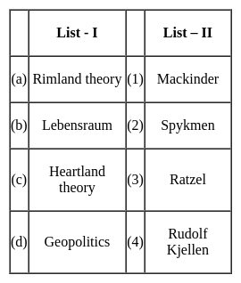
Match the concepts (List - I) with their proponents (List - II) selecting correct answer from the codes given below :

Detailed Solution for MH SET Paper 2 Mock Test - 10 (Geography) - Question 30

The correct answer is (a) - (2), (b) - (3), (c) - (1), (d) - (4)

Key Points

  • Heartland theory was given by British political geographer H J Mackinder in the year 1904. "The Geographical Pivot of History" is an article submitted by Halford John Mackinder in 1904 to the Royal Geographical Society that advances his heartland theory. In this article, Mackinder extended the scope of geopolitical analysis to encompass the entire globe.
  • Heartland theory believed that whoever controls the heartland( Siberia and part of central Asia) will control the world islands whereas rimland theory believed that whoever controls the rimland (Inner marginal crescent) comprised Europe, North Africa, West Asia, India, South East Asia, and part of China will control the world islands
  • Spykeman propounded the Rimland theory in opposition to the Heartland theory of Mackinder. Spykman proposed a theory that countered Mackinder's Heartland Theory. According to his rimland theory, the coastal areas or littorals of Eurasia are key to controlling the World Island, not the Heartland. As per Spykman, landlocked states usually faced security challenges from their immediate neighbors.
  • The ideology of Nazism Party workers and also Adolf Hitler was Lebensraum which meant that the living space or territory area extended to enable the material resources and the power of the German Nation and also established the new territory for their people settlement.
  • The term Lebensraum was coined by the German geographer, Friedrich Ratzel (1844-1904). During the last two decades of the 19th century, Ratzel developed a theory according to which the development of all species, including humans, is primarily determined by their adaptation to geographic circumstances.
  • Geopolitics, analysis of the geographic influences on power relationships in international relations.
  • The word geopolitics was originally coined by the Swedish political scientist Rudolf Kjellén about the turn of the 20th century, and its use spread throughout Europe in the period between World Wars I and II (1918–39) and came into worldwide use during the latter.
View more questions
60 tests
Information about MH SET Paper 2 Mock Test - 10 (Geography) Page
In this test you can find the Exam questions for MH SET Paper 2 Mock Test - 10 (Geography) solved & explained in the simplest way possible. Besides giving Questions and answers for MH SET Paper 2 Mock Test - 10 (Geography), EduRev gives you an ample number of Online tests for practice
Download as PDF