MAHA TET Exam  >  MAHA TET Tests  >  MH SET Mock Test Series 2025  >  MH SET Paper 2 Mock Test - 2 (Geography) - MAHA TET MCQ

MH SET Paper 2 Mock Test - 2 (Geography) - MAHA TET MCQ


Test Description

30 Questions MCQ Test MH SET Mock Test Series 2025 - MH SET Paper 2 Mock Test - 2 (Geography)

MH SET Paper 2 Mock Test - 2 (Geography) for MAHA TET 2025 is part of MH SET Mock Test Series 2025 preparation. The MH SET Paper 2 Mock Test - 2 (Geography) questions and answers have been prepared according to the MAHA TET exam syllabus.The MH SET Paper 2 Mock Test - 2 (Geography) MCQs are made for MAHA TET 2025 Exam. Find important definitions, questions, notes, meanings, examples, exercises, MCQs and online tests for MH SET Paper 2 Mock Test - 2 (Geography) below.
Solutions of MH SET Paper 2 Mock Test - 2 (Geography) questions in English are available as part of our MH SET Mock Test Series 2025 for MAHA TET & MH SET Paper 2 Mock Test - 2 (Geography) solutions in Hindi for MH SET Mock Test Series 2025 course. Download more important topics, notes, lectures and mock test series for MAHA TET Exam by signing up for free. Attempt MH SET Paper 2 Mock Test - 2 (Geography) | 100 questions in 120 minutes | Mock test for MAHA TET preparation | Free important questions MCQ to study MH SET Mock Test Series 2025 for MAHA TET Exam | Download free PDF with solutions
MH SET Paper 2 Mock Test - 2 (Geography) - Question 1

The Concentric circle theory of city morphology was developed by:

Detailed Solution for MH SET Paper 2 Mock Test - 2 (Geography) - Question 1

The correct answer is E. Burgess.
Important Points
Concentric circle theory

  • The Concentric Circle Theory of city morphology was developed by sociologist E. Burgess in 1925.
  • Burgess was interested in studying the social organization of cities, particularly the ways in which different social groups interacted with each other in urban areas.

According to Burgess, cities grow in a series of concentric circles, with each circle representing a different type of land use and social group.

  • The innermost circle is the central business district (CBD), which is the economic and commercial hub of the city. Surrounding the CBD is the zone of transition, which is a mixed-use area characterized by industrial and residential land uses.
  • Burgess argued that this area was often home to marginalized and transient populations, including recent immigrants, the working poor, and the homeless.

The next concentric circle is the zone of working-class homes,

  • which is a predominantly residential area characterized by low-income housing and blue-collar workers. Beyond this is the zone of better residences, which is a middle-class residential area characterized by single-family homes and a higher standard of living.

Finally, the outermost concentric circle is the commuter zone, which is a suburban area where people live who commute to the central city for work.

Burgess believed that this pattern of concentric circles was universal and could be observed in cities around the world. He argued that the concentric circle model reflected the natural tendency of social groups to sort themselves based on their socio-economic status and land use needs.

In conclusion, the Concentric Circle Theory of city morphology was developed by E. Burgess and proposes that cities grow in a series of concentric circles, each with a different type of land use and social group. The innermost circle is the CBD, followed by the zone of transition, zone of working-class homes, zone of better residences, and finally the commuter zone.

MH SET Paper 2 Mock Test - 2 (Geography) - Question 2

Which of the following is not a part of Social Geography?

Detailed Solution for MH SET Paper 2 Mock Test - 2 (Geography) - Question 2
MH SET Paper 2 Mock Test - 2 (Geography) - Question 3

Heritage power project Sonapani mini-hydel power project is located in which state?

Detailed Solution for MH SET Paper 2 Mock Test - 2 (Geography) - Question 3

Sonapani Power Project is the name of a British Era heritage mini-hydel project located at Lum Kshaid in Meghalaya. It was set up in 1925, abandoned in 1982, and again construction started in 2001. The heritage project of 1.5 MW capacity was recommissioned in December 2011.

MH SET Paper 2 Mock Test - 2 (Geography) - Question 4

In which stage of landscape evolution do relief features become more subdued?

Detailed Solution for MH SET Paper 2 Mock Test - 2 (Geography) - Question 4

Answer: Option 2) Mature stage.

Key Points

  • Understanding the stages of landscape evolution is essential for comprehending how landforms change over time.
  • One critical aspect of this evolution is the transformation of relief features, which become more subdued as landscapes progress through various stages.
  • Mature stage: The mature stage represents a transitional phase where relief features begin to become more subdued.
  • While some rugged terrain may still persist, the overall topography becomes gentler, with smoother slopes and less pronounced landforms.
  • Rivers widen their valleys through lateral erosion, and the landscape achieves a more balanced state between erosion and uplift.

Additional Information 

  • Youthful stage: In the youthful stage of landscape evolution, relief features are typically pronounced, characterized by steep slopes, rugged terrain, and prominent landforms such as peaks and valleys. This stage is marked by intense erosion and rapid changes in topography as geological forces sculpt the landscape with vigor.
  • Old age stage: In the old age stage, relief features are significantly subdued, and the landscape exhibits low relief with nearly level surfaces. Rivers meander across broad floodplains, and mountain ranges are reduced to residual hills and isolated remnants. This stage is characterized by extensive erosion, leading to the formation of peneplains—nearly level surfaces eroded to a uniform low elevation.
  • Transitional stage: The transitional stage represents a period of flux between different stages of landscape evolution. Relief features may exhibit characteristics of both youthful and mature stages as the landscape undergoes gradual transformation. This stage is marked by dynamic processes as the landscape adjusts to changing geological and environmental conditions.

Important Points 

  • The transformation of relief features is influenced by a variety of factors, including the type and intensity of erosion, tectonic activity, and climatic conditions.
  • Different landscapes may exhibit variations in the rate and sequence of relief feature modification, depending on their geological history and environmental context.
MH SET Paper 2 Mock Test - 2 (Geography) - Question 5

What is the primary driving force behind the cycle of erosion theory?

Detailed Solution for MH SET Paper 2 Mock Test - 2 (Geography) - Question 5

Answer: Option 2) Weathering and erosion.

Key Points

  • The primary driving force behind the cycle of erosion theory is crucial to understanding the dynamic processes shaping the Earth's surface.
  • This theory, proposed by William Morris Davis, elucidates the intricate interplay of geological forces that mold landscapes over geological time scales.
  • Weathering and erosion: This option accurately reflects the primary driving force behind the cycle of erosion theory.
  • Weathering refers to the breakdown of rock into smaller particles, while erosion involves the removal and transportation of these particles.
  • Together, weathering and erosion shape the Earth's surface over time, sculpting landscapes into various forms.

Important Points

  •  Weathering can be categorized into mechanical (physical) weathering and chemical weathering.
  • Mechanical weathering involves physical processes like freeze-thaw cycles and abrasion, while chemical weathering involves chemical reactions that alter the mineral composition of rocks.
  • Erosion is predominantly carried out by agents such as water, wind, ice (glaciers), and gravity.
  • These agents sculpt landscapes by transporting weathered material from one location to another, leading to the formation of various landforms such as valleys, canyons, and deltas.

Additional Information 

Tectonic subsidence: While tectonic movements play a significant role in landscape evolution by causing uplift and subsidence, tectonic subsidence alone does not encompass the entire process described by the cycle of erosion theory. It contributes to changes in elevation but is not the sole driving force behind erosion and landscape development.

Climate variability: Climate variability influences erosion rates and patterns by affecting factors such as precipitation, temperature, and vegetation cover. However, while climate variability is a significant factor in landscape evolution, it is not the primary driving force described by the cycle of erosion theory.

Glacial deposition: Glacial deposition, a process where glaciers deposit sediments as they advance and retreat, is a component of landscape evolution, particularly in regions influenced by glaciation. However, it is a specific aspect of erosion and deposition rather than the overarching driving force behind the cycle of erosion theory.

MH SET Paper 2 Mock Test - 2 (Geography) - Question 6
An international agreement linked to the United Nations Framework Convention on Climate Change is:
Detailed Solution for MH SET Paper 2 Mock Test - 2 (Geography) - Question 6

An international agreement linked to the United Nations Framework Convention on Climate Change is Kyoto Protocol.

Key PointsKyoto Protocol:

  • The 1st Conference of the Parties (COP-1) decided that the aim of Annex I Parties stabilizing their emissions at 1990 levels by the year 2000 was "not adequate", and further discussions at later conferences led to the Kyoto Protocol in 1997.
  • The Kyoto Protocol was concluded and established legally binding obligations under international law, for developed countries to reduce their greenhouse gas emissions in the period 2008-2012.
  • The 2010 United Nations Climate Change Conference produced an agreement stating that future global warming should be limited to below 2 °C (3.6 °F) relative to the pre-industrial level.
  • The Kyoto Protocol had two commitment periods, the first of which lasted from 2008 to 2012.
  • The Protocol was amended in 2012 to encompass the second one for the period 2013–2020 in the Doha Amendment.
MH SET Paper 2 Mock Test - 2 (Geography) - Question 7

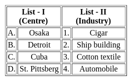
Match List - I with List - II and select the correct answer from the code given below the lists.

Detailed Solution for MH SET Paper 2 Mock Test - 2 (Geography) - Question 7

The correct answer is Option 4.

Key Points

  • Osaka is an important textile centre of Japan, also known as the Manchester of Japan.
    • The textile industry developed in Osaka due to several geographical factors.
    • The textile industry in Osaka depends completely upon imported raw materials.
    • Cotton is imported from Egypt, India, China and USA. The finished product is mostly exported and has a good market.
  • Detroit is best known as the centre of the U.S. automobile industry, and the "Big Three" Auto manufacturers General Motors, Ford, and Stellantis North America are all headquartered in Metro Detroit.
  • Cuba is the largest island in the Caribbean, but only tobacco grown in the far western region of the island is best for cigars.
    • Tobacco grown there takes on the flavours of the soil and is influenced by the microclimate in that particular region.
  • St. Pittsburg is the second-largest city in Russia and is a famous centre of shipbuilding.
  • Pittsburgh is an important steel and iron city in the United States of America. The processing of iron began in Pittsburgh in mid 19th century. Hence the option 4 is correct.
  • The Pittsburgh district is the capital of the world of iron and steel.
MH SET Paper 2 Mock Test - 2 (Geography) - Question 8
In which layer of the atmosphere is Ozone gas concentrated?
Detailed Solution for MH SET Paper 2 Mock Test - 2 (Geography) - Question 8

The correct answer is Stratosphere.

Key Points

  • The atmosphere has 5 layers.
  • These are:
    • Troposphere
    • Stratosphere
    • Mesosphere
    • Thermosphere 
    • Exosphere
  • The troposphere is the lowest layer of Earth's atmosphere 
  • Its average height is 13 km.
  • The stratosphere lies above the Troposphere and extends up to a height of 50 km.
  • The stratosphere contains a layer of ozone gas.
  • The mesosphere lies above the Stratosphere and extends up to 80 km.
  • The ionosphere is a part of the Thermosphere.
  • It helps in radio transmission.
  • The exosphere is the upper layer of the atmosphere and has very thin air.

 Thus, we can say that Stratosphere is Ozone gas concentrated.

MH SET Paper 2 Mock Test - 2 (Geography) - Question 9
Which of the following statements are true? Choose your answer from the code given below:

(a) The industrial region of Mumbai-Pune flourished due to the development of cotton textile industry.

(b) The Kollam-Thiruvanathapuram industrial region has agricultural processing and market-oriented light industries.

(c) Chotanagpur industrial region is called Ruhr of India.

(d) The Gurgaon-Delhi-Meerut industrial region is famous from heavy industries.

Detailed Solution for MH SET Paper 2 Mock Test - 2 (Geography) - Question 9

 The industrial region in Mumbai-Pune developed in the time of American Civil War due to high growth in cotton textile industry. The Chotanagpur industrial region has coal and iron ore deposits. Thus, it is called as Ruhr of India. The Kollam-Thiruvanathapuram industrial region is far away from the mineral deposits. Thus, industries here are agro-based and market oriented light industries. Same applies for the Gurgaon-Delhi-Meerut industrial regions. Thus, (d) is false and all others are true.

Thus, the correct answer is A.

MH SET Paper 2 Mock Test - 2 (Geography) - Question 10

Consider the following statements regarding Geothermal Energy:

1. Generated due to Radioactive decay of the material inside the surface of the Earth.

2. India does not contribute in its production due to its location near the Himalayas.

Which of the statements given above is/are correct?

Detailed Solution for MH SET Paper 2 Mock Test - 2 (Geography) - Question 10

The correct answer is 1 only.Key PointsGeothermal Power

  • Geothermal energy is the thermal energy in the Earth's crust.
  • The high temperature and pressure in Earth's interior cause some rock to melt and solid mantle to behave plastically.
  • It originates from the:
    • Formation of the planet.
    • Radioactive decay of materials. Hence statement 1 is correct.
  • This results in parts of the mantle convecting upward since it is lighter than the surrounding rock.
  • USA has the world’s largest geothermal power plants.
  • Norway was the first country in the world to develop hydroelectricity.
  • Geothermal energy taps into the thermal energy and radioactive decay leftover from the formation of the Earth.
  • A small portion of the core’s heat comes from the friction and gravitational pull formed when Earth was created more than 4 billion years ago.
  • However, the vast majority of Earth’s heat is constantly generated by the decay of radioactive isotopes, such as potassium-40 and thorium-232.
  • Puga Valley:
    • It is situated in the Changthang Valley in the southeastern part of Ladakh
    • It is a region of great significance known for its natural beauty and geothermal activities.
    • Puga also has a hot sulphur spring. Hence statement 2 is incorrect.
  • The promising geothermal sites for direct heat use applications are:
    • Rajgir in Bihar, Manikaran in Himachal Pradesh,
    • Surajkund in Jharkhand, Tapoban in Uttarakhand & Sohana region in Haryana.
MH SET Paper 2 Mock Test - 2 (Geography) - Question 11
What do you mean by 'Demographic Dividend'?
Detailed Solution for MH SET Paper 2 Mock Test - 2 (Geography) - Question 11

The correct answer is option 1, i.e rise in the rate of economic growth due to a higher share of working-age people in a population.

According to the United Nations Population Fund (UNFPA)

  • A demographic dividend means - the economic growth potential that can result from shifts in a population’s age structure, mainly when the share of the working-age population (15 to 64) is larger than the non-working-age share of the population (14 and younger, and 65 and older).
  • India has one of the youngest populations in an aging world.
  • By 2020, the median age in India will be just 28.
  • Compared to this, in China and the US, the median age would be 37, 45 in Western Europe, and 49 in Japan.
  • According to Economic Survey 2018-19, India’s Demographic Dividend will peak around 2041, when the share of working-age,i.e. 20-59 years, the population is expected to hit 59%.
  • The age group of 15-59 years would reach 65% in 2036.
MH SET Paper 2 Mock Test - 2 (Geography) - Question 12

Which of the following is/are the 'push factor' affecting migration?

(A) Better opportunities for work

(B) Better health facilities

(C) Poorer health facilities

(D) Absence of good educational institution

Choose the correct option.

Detailed Solution for MH SET Paper 2 Mock Test - 2 (Geography) - Question 12
  • Human migration is the movement of people from one place to another with intention of settling, permanently or temporarily, at a new location.

Key Points

  1. Push factors “push” people away from their homes and include things like war. Pull factors “pull” people to a new home and include things like better opportunities.
  2. Poorer health facilities and the absence of good educational institutions push people to migrate, so these are the push factors of migration.
  3. Better opportunities for work and better health facilities pull people and so, these are pull factors of migration.

Hence, Poor health facilities and the absence of good educational institutions are the push factors for migration.

MH SET Paper 2 Mock Test - 2 (Geography) - Question 13
Given below are two statements. One is labelled as Assertion (A) and the other is labelled as Reason (R).

Assertion (A): The temperature increases in the stratosphere.

Reason (R) : The boundary between stratosphere and mesosphere is called as stratopause.

Select the correct answer from options given below:

Detailed Solution for MH SET Paper 2 Mock Test - 2 (Geography) - Question 13

The stratosphere has the additional ozone layer. This layer absorbs the harmful ultraviolet rays of the sun. That leads to increase in the temperature of the stratosphere. The boundary between mesosphere and stratosphere is called stratopause, which is located at about 50 km from the earth’s crust. Thus, both (A) and (R) are true, but (R) is not the correct explanation of (A).

Thus, the correct answer is B.

MH SET Paper 2 Mock Test - 2 (Geography) - Question 14

In India which age group is considered as economically productive?

Detailed Solution for MH SET Paper 2 Mock Test - 2 (Geography) - Question 14

The age composition of a population refers to the number of people in different age groups in a country. The number and percentage of a population found within the children, working-age and aged groups are notable determinants of the population’s social and economic structure. The population of a nation is, generally, grouped into three broad categories.
Key-Points

Children (generally below 15 years)

  • They are considered an economically unproductive group.
  • The people need to be provided with food, clothing, education, and medical care.

Working Age (15–59 years)

  • This age group is considered economically productive and biologically reproductive.
  • They comprise the working population

Aged (Above 59 years)

  • People of this age group can be economically productive though they may have retired.
  • They may be working voluntarily but they are not available for employment through recruitment.

So, it is clear that the age group of 15 - 59 years is considered as economically productive in our country.

Hence, option 2 is the correct answer.

MH SET Paper 2 Mock Test - 2 (Geography) - Question 15
The concept of Lebensraum gained popularity in the field of political geography following the publication of
Detailed Solution for MH SET Paper 2 Mock Test - 2 (Geography) - Question 15
 
  • The monumental Politische Geographie (1897) is described as the 1st book on modern political geography by Friedrich Ratzel that is based on the organismic analogy, following which the concept of Lebensraum gained popularity.
  • The concept of Lebensraum states that all living organisms are involved in an endless struggle for space and the most powerful will have the largest space. 
MH SET Paper 2 Mock Test - 2 (Geography) - Question 16
Who contribute in the field of Hydrostatics  hydrokinetics and military sciences?
Detailed Solution for MH SET Paper 2 Mock Test - 2 (Geography) - Question 16

The correct answer is E. Kant .
Key Points

Immanuel Kant:

  • Born in 1724 at Konigsberg in East Prussia (Russia) and passed away in 1804.
  • Kant was more of an ‘armchair geographer’
  • His contribution in the fields of astronomy, geology, and geography.
  • He was regarded as the ‘father of exceptionalism’
  • Kant lectured with great proficiency not only in the fields of philosophy, mathematics, physics, and mechanical sciences like mechanics, hydrostatics, and hydrokinetics but also in military sciences like fortification and pyro-techniques.​​

Additional Information

Contribution:

  • From 1756 to 1796, Kant offered a regular course of lectures on physical geography.
  • The physical geography which Kant developed was essentially ‘anthropocentric’ in nature and content.
  • Empirical knowledge è (i) through pure reason, or (ii) through the senses.
  • Anthropology: dealt with soul or man, physical geography: dealt with Nature.
  • Classification of knowledge:
    • Logical classification: on the basis of morphological similarities and gave rise to systematic sciences
    • Physical classification: the base is time or space. History, related to time (chronological) and Geography related to space (chronological).
MH SET Paper 2 Mock Test - 2 (Geography) - Question 17
Consider the following statements about Losch’s theory of industrial location and choose which amongst them is true:

i. Goods have high demand with low prices.

ii. The demand curve rotated round the production point to give shape.

iii. As the competition increases, the market areas becomes hexagonal.

Detailed Solution for MH SET Paper 2 Mock Test - 2 (Geography) - Question 17

Losch’s theory attempts to explain the size and shape of market area within which a location would command the largest revenue. It is assumed that the demand varies inversely with price. This gives us a demand pattern. The demand curve can be rotated round the production point to give the size and shape of the market space. With increasing competition, the size of the market area becomes hexagonal. They also become smaller as the markets are competed away.

Thus, the Correct answer is D.

MH SET Paper 2 Mock Test - 2 (Geography) - Question 18
Consider the following statements:

a. Flow maps tell us what is flowing or being migrated

b. It tells us about the direction of the movement

c. Flow maps give a general information about what is flowing and how it is flowing

d. Flow maps also tell us about the speed at which the flow occurs.

Which of the above statements are correct?

Detailed Solution for MH SET Paper 2 Mock Test - 2 (Geography) - Question 18

These are the most important forms of dynamic maps in which the movement of goods, information and people between and among places are shown. The flow maps are used to show the movement of almost anything such as people, products and natural resources. The actual route of movement on a map is considered and the quantitative impression is conveyed by the width of the line.

Speed at which the flow is occurring can also be shown with the help of flow maps, but they are a totally different thing. These are known as speed flow maps or isochronic cartograms. General flow maps do not show the speed.

Thus, the Correct answer is C.

MH SET Paper 2 Mock Test - 2 (Geography) - Question 19

In India which age group is considered as economically productive?

Detailed Solution for MH SET Paper 2 Mock Test - 2 (Geography) - Question 19

The age composition of a population refers to the number of people in different age groups in a country. The number and percentage of a population found within the children, working-age and aged groups are notable determinants of the population’s social and economic structure. The population of a nation is, generally, grouped into three broad categories.
Key-Points

Children (generally below 15 years)

  • They are considered an economically unproductive group.
  • The people need to be provided with food, clothing, education, and medical care.

Working Age (15–59 years)

  • This age group is considered economically productive and biologically reproductive.
  • They comprise the working population

Aged (Above 59 years)

  • People of this age group can be economically productive though they may have retired.
  • They may be working voluntarily but they are not available for employment through recruitment.

So, it is clear that the age group of 15 - 59 years is considered as economically productive in our country.

Hence, option 2 is the correct answer.

MH SET Paper 2 Mock Test - 2 (Geography) - Question 20
What is the full form of SEZ?
Detailed Solution for MH SET Paper 2 Mock Test - 2 (Geography) - Question 20

A special economic zone (SEZ) is a dedicated zone wherein businesses enjoy simpler taxes and easier legal compliances.

  • SEZs are located within a country’s national borders. However, they are treated as foreign territory for tax purposes.
  • This is why the supply from and to special economic zones have a little different treatment than the regular supplies.
  • In simple words, even when SEZs are located in the same country, they are considered to be located in a foreign territory.
  • SEZs are not considered a part of India. 
  • Based on this it can be clearly said that under GST, any supply to or by a Special Economic Zone developer or Special Economic Zone unit is considered to be an Interstate supply and Integrated Goods and Service Tax (IGST) will be applicable.

Additional Information

  • A special economic zone (SEZ) is an area in a country that is subject to different economic regulations than other regions within the same country.
  • The economic regulations of special economic zones (SEZs) tend to be conducive to—and attract—foreign direct investment (FDI).
  • Special economic zones (SEZs) are typically created in order to facilitate rapid economic growth by leveraging tax incentives to attract foreign investment and spark technological advancement.
  • While many countries have set up special economic zones (SEZs), China has been the most successful in using SEZs to attract foreign capital.

Hence, the correct answer is Special Economic Zone.

MH SET Paper 2 Mock Test - 2 (Geography) - Question 21
Who  emphasized the point that geography is not a dry gazetteer of names of places, rivers, mountains, and trade routes?
Detailed Solution for MH SET Paper 2 Mock Test - 2 (Geography) - Question 21

The correct answer is C. Ritter.
Key Points

  • German geographer Carl Ritter is commonly associated with Alexander von Humboldt as one of the founders of modern geography.
  • However, most acknowledge Ritter's contributions to the modern discipline to be somewhat less significant than those of von Humboldt, especially as Ritter's life work was based on the observations of others.
  • Ritter, in his class lectures, emphasized the point that geography is not a dry gazetteer of names of places, rivers, mountains, and trade routes.
  • It is a subject of great importance that deals with man and nature’s interrelationship. 
  • He developed the concept of “unity in diversity.” Ritter was chiefly concerned with studies of human geography.
  • He believed, as did Vidal de la Blache much later, that earth and its inhabitants stand in the closest reciprocal relations, and one cannot be truly presented in all its relationships without the other.
  • Hence history and geography must always remain inseparable.
  • Land affects the inhabitants and the inhabitants of the land. In simple words, every naturally bounded area is united in respect of climate, production, culture, population, and history.
MH SET Paper 2 Mock Test - 2 (Geography) - Question 22
Which type of soil is predomainantly found in the Deccan lava tract in India?
Detailed Solution for MH SET Paper 2 Mock Test - 2 (Geography) - Question 22

The correct answer is Black Soil.

Key Points

  • Black Soil is predomainantly found in the Deccan lava tract in India.
  • On the Deccan lava plateau and the Malwa Plateau, where there is moderate rainfall and underlying basaltic rock, black soils, which are derivatives of trap lava, are mostly found in interior Gujarat, Maharashtra, Karnataka, and Madhya Pradesh.
  • Black soils have a high percentage of clay, which causes large fissures to form during the dry season, yet their iron-rich granular structure prevents wind and water erosion.
  • Despite having little humus, they are very moisture-retentive and react well to irrigation.
  • These soils can also be found on several outlying tracts where river processes have caused the underlying basalt to be moved from its original position.

Important Points

  • Alluvium is loose clay, silt, sand, or gravel that has been deposited by flowing water on a stream bed, on a floodplain, in an alluvial fan or beach, or in environments that are similar.
  • About 13% of the soils on Earth are red soil, which often forms in warm, moderate, and humid areas.
  • Heavy rainfall, periods of wet and dry weather, and high temperatures all contribute to the formation of laterite soil, which is then primarily composed of iron and aluminium oxides once the soil has been leached.
MH SET Paper 2 Mock Test - 2 (Geography) - Question 23
Rank-size rule was given by
Detailed Solution for MH SET Paper 2 Mock Test - 2 (Geography) - Question 23

George Zipf gave the rank-size rule in 1949. The rank-size rule describes the relation between the size of the city and the rank of the city. This relation is shown by the formula, Pr=P1/r. Here Pr is the population of the ‘r’ ranked city, P1 is the population of the largest city and r is the rank of the city. For example, if the city X is ranked 4th, the population of X P1/4.

Thus, the correct answer is B.

MH SET Paper 2 Mock Test - 2 (Geography) - Question 24

After which one of the following tribes of India has a supercontinent of ancient geological history of the world been named?

Detailed Solution for MH SET Paper 2 Mock Test - 2 (Geography) - Question 24

After Gonds tribes of India has a supercontinent of ancient geological history of the world been named. The Gond people are Adivasi (indigenous people) of India that speak Dravidian languages and are listed as a Scheduled Tribe for the purpose of India's system of positive discrimination. The name "Gondwana" was proposed in 1872 by Medlicott from the ancient kingdom of the Gonds, one of the principal aboriginal tribes believed to have inhabited a large part of central India.

MH SET Paper 2 Mock Test - 2 (Geography) - Question 25

For cotton cultivation which among the following soils is considered most suitable?

Detailed Solution for MH SET Paper 2 Mock Test - 2 (Geography) - Question 25

For cotton cultivation Black Soil is considered most suitable.

Thus, the correct answer is B.

MH SET Paper 2 Mock Test - 2 (Geography) - Question 26

Solifluction is a geomorphic process involving a special type of soil flow that is noticed in

Detailed Solution for MH SET Paper 2 Mock Test - 2 (Geography) - Question 26

The correct answer is permafrost regions.

Key Points

  • Solifluction refers to the progressive movement of a mass down a slope ("mass wasting") as a result of the freeze-thaw activity. Hence option 3 is correct.
  • It can also be defined as a type of creep that occurs in cold regions or at high elevations and occurs when the mass of saturated rock waste flows down the slope.
  • The slow downslope movement of the surface rocks is referred to as soil creep.
  • It's both a continuous process and a surface phenomenon that happens on slopes.

Hence option 3 is correct.

MH SET Paper 2 Mock Test - 2 (Geography) - Question 27

Which metal is the most abundant in the earth crust?

Detailed Solution for MH SET Paper 2 Mock Test - 2 (Geography) - Question 27

Most abundant element is Oxygen followed by Silicon. Both of these are non-metals. Silicon is followed by Aluminium which is most abundant metal.

MH SET Paper 2 Mock Test - 2 (Geography) - Question 28

Which of the following statement is correct about weathering?

Detailed Solution for MH SET Paper 2 Mock Test - 2 (Geography) - Question 28

The correct answer is option 1.

Key Points

  • Weathering:
    • Weathering is the disintegration of rocks, soil, and minerals under the influence of physical (heat, pressure) and chemical (leaching, oxidation and reduction, hydration) agents.
    • As very little or no motion of materials takes place in weathering, it is an in-situ or on-site process.
    • The weathered material is carried farther away by erosion.
      There are three major groups of weathering processes: 1) chemical; 2) physical or mechanical; 3) biological weathering processes. All the types of weathering often go hand in hand.
    • Weathering due to dissolution, solution, carbonation, hydration, oxidation, and reduction that act on the rocks is termed chemical weathering. Hence, statement 3 is incorrect.
    • Expansion of solids due to temperature change, hydration, and crystallization is referred to as physical weathering. Hence, statement 1 is correct
    • The reason behind exhalation sheets is unloading and pressure release
    • Biological weathering is the removal of minerals from the environment due to the growth or action of organisms. Hence, statement 2 is incorrect.
MH SET Paper 2 Mock Test - 2 (Geography) - Question 29
Consider the following statements:-

a) Sea level Changes are only affected by Eustatic changes.

b) Marine sediments depict about global sea level change.

c) Evidences of sedimentary deposits of various sorts depict sea level changes during the pre-quaternary stages.

d) Sea level has risen by about 10 to 16 cm in the past 100 years.

Which of the following statements is correct?

Detailed Solution for MH SET Paper 2 Mock Test - 2 (Geography) - Question 29

The sea level changes are not only affected by eustatic changes such as the melting of ice and global warming but also by tectonic changes such as Isostatic changes, epeirogenetic and orogenetic changes. Various other evidences such as elevated shorelines, the deposition of organic and inorganic deposits in the continental shelves support the sea level changes. But recently, the change in the sea level has mostly been due to the factors such as global warming due to anthropogenic conditions and melting of glaciers and ice sheets.

MH SET Paper 2 Mock Test - 2 (Geography) - Question 30

In an ecotone, the species which become abundant are called:

Detailed Solution for MH SET Paper 2 Mock Test - 2 (Geography) - Question 30

An ecotone is a transition area between two biomes but different patches of the landscape, such as forest and grassland. The ecotone contains not only species common to the communities on both sides; it may also include a number of highly adaptable species that tend to colonize such transitional areas. This can produce an edge effect along the boundary line, with the area displaying a greater than usual diversity of species. The phenomenon of increased variety of plants as well as animals at the community junction is called the “edge effect” and is essentially due to a locally broader range of suitable environmental conditions or ecological niches.

View more questions
60 tests
Information about MH SET Paper 2 Mock Test - 2 (Geography) Page
In this test you can find the Exam questions for MH SET Paper 2 Mock Test - 2 (Geography) solved & explained in the simplest way possible. Besides giving Questions and answers for MH SET Paper 2 Mock Test - 2 (Geography), EduRev gives you an ample number of Online tests for practice
Download as PDF