MAHA TET Exam  >  MAHA TET Tests  >  MH SET Mock Test Series 2025  >  MH SET Paper 2 Mock Test - 4 (Geography) - MAHA TET MCQ

MH SET Paper 2 Mock Test - 4 (Geography) - MAHA TET MCQ


Test Description

30 Questions MCQ Test MH SET Mock Test Series 2025 - MH SET Paper 2 Mock Test - 4 (Geography)

MH SET Paper 2 Mock Test - 4 (Geography) for MAHA TET 2025 is part of MH SET Mock Test Series 2025 preparation. The MH SET Paper 2 Mock Test - 4 (Geography) questions and answers have been prepared according to the MAHA TET exam syllabus.The MH SET Paper 2 Mock Test - 4 (Geography) MCQs are made for MAHA TET 2025 Exam. Find important definitions, questions, notes, meanings, examples, exercises, MCQs and online tests for MH SET Paper 2 Mock Test - 4 (Geography) below.
Solutions of MH SET Paper 2 Mock Test - 4 (Geography) questions in English are available as part of our MH SET Mock Test Series 2025 for MAHA TET & MH SET Paper 2 Mock Test - 4 (Geography) solutions in Hindi for MH SET Mock Test Series 2025 course. Download more important topics, notes, lectures and mock test series for MAHA TET Exam by signing up for free. Attempt MH SET Paper 2 Mock Test - 4 (Geography) | 100 questions in 120 minutes | Mock test for MAHA TET preparation | Free important questions MCQ to study MH SET Mock Test Series 2025 for MAHA TET Exam | Download free PDF with solutions
MH SET Paper 2 Mock Test - 4 (Geography) - Question 1

Who was the first scholar who divided the world landmass into three continents-Europe, Asia and Libya(Africa)?

Detailed Solution for MH SET Paper 2 Mock Test - 4 (Geography) - Question 1

The correct answer is Herodotus.

Herodotus is credited with being the first person to divide the world's landmass into three continents: Europe, Asia, and Libya (Africa).

Key Points

  • The ancient Greek philosopher and geographer, Herodotus, is credited with being the first person to divide the world's landmass into three continents: Europe, Asia, and Libya (Africa).
  • He did this in his work "Histories," which was written in the 5th century BCE.
  • In this work, Herodotus described his travels and the customs and cultures of the people he encountered.
  • He also provided the first known geographical and ethnographical description of the world as known to the Greeks of his time.
  • He used the terms
    • "Europe" refers to the lands north of the Mediterranean Sea and the Aegean Sea,
    • "Asia" refers to the lands east of the Aegean Sea and
    • "Libya" refers to the African continent.

MH SET Paper 2 Mock Test - 4 (Geography) - Question 2

Read the following statements and choose correct answer from the code given below:

(a) El Nino current contributes to the global warming.

(b) El Nino is also associated with droughts in Australia.

(c) El Nino is a cold current.

(d) El Nino was discovered in the nineteenth century.

Code:

Detailed Solution for MH SET Paper 2 Mock Test - 4 (Geography) - Question 2

The El Nino is warm water current that flows from Papua New Guinea towards Peru. It occurs every 3 to 8 years. It is considered to be one of the causes of global warming and also leads to droughts in Australia. It was discovered in the seventeenth century.

Thus, the correct answer is A.

MH SET Paper 2 Mock Test - 4 (Geography) - Question 3

India's population growth is characterized by

Detailed Solution for MH SET Paper 2 Mock Test - 4 (Geography) - Question 3

India's population growth is characterised by decadal (on every 10 year basis) growth of population on every census basis, which is based on an increase in the birth rate and decrease in death rate.

MH SET Paper 2 Mock Test - 4 (Geography) - Question 4

Choose the correct statement from below:

Statement I:The concentration of the economy in the core city begins as a result of innovation. capital accumulation and industrial growth.

Statement II: The pre-industrial (agricultural) society, with localized economies and a small-scale settlement structure.

Detailed Solution for MH SET Paper 2 Mock Test - 4 (Geography) - Question 4

The correct answer is Both Statement I & Statement II are true.
Key Points

Both statements are taken from Core-periphery model of economic development.

  • This model was developed in 1963 by John Friedmann.
  • It is a model of the spatial organization of human activity based upon the equal distribution of power in the economy and society.

Stage 1 (Pre-industrial)

  • The pre-industrial (agricultural) society, with localized economies and a small-scale settlement structure.
  • Each settlement is fairly isolated, activities are dispersed and mobility is low.
  • There are limited differences between spatial entities in terms of levels of economic development

 Hence ,Statement I is true.

Stage 2 (Transitional)

  • The concentration of the economy in the core city begins as a result of innovation. capital accumulation and industrial growth.
  • The specific reasons behind this concentration are often not too clear, location (better access) being a significant factor, but the fact remains that a dominant centre emerges within an urban system to become its growth pole.
  • Trade and mobility increase, but within a pattern dominated by the core even if the overall mobility remained low.

 Hence ,Statement II is true.
Additional Information
Stage 3 (Industrial

  • Through a process of economic growth and diffusion, other growth centres emerge.
  • The main reasons for deconcentration are increasing input costs (mainly labor and land) in the core area.

Stage 4 (Post-industrial)

  • The urban system becomes fully integrated and spatial inequalities are reduced significantly.
  • The distribution of economic activities creates a specialization and a division of labor linked with intense flows along high-capacity transport corridors.

MH SET Paper 2 Mock Test - 4 (Geography) - Question 5

Which of the following is/are the ideal conditions for temperature inversion to occur?

A. Cloudy skies

B. Calm and stable air

C. Long summer days

Select the correct answer using the codes given below:

Detailed Solution for MH SET Paper 2 Mock Test - 4 (Geography) - Question 5

The correct answer is B only.

Key Points

  • The Ideal conditions for temperature inversion are:
    • Long hours, so that it is greater than the incoming radiation than the outgoing radiation.
    • Clear skies that allow radiation to escape unhindered.
    • Calm and stable air, such that, at lower speeds, there is no vertical mixing.
  • A temperature inversion is the reversal of the natural temperature activity in the troposphere, where a layer of cool air on the surface is replaced by a layer of warmer air. (The temperature normally decreases with height under normal conditions).

Additional Information

  • An inversion serves as a limit on the airflow from the layers below upwards. As a consequence, the convection produced by air heating from below is limited to levels below the inversion stage.
  • Likewise, the diffusion of dust, smoke, and other air contaminants is reduced.
  • Convective clouds do not rise high enough to create showers in regions where a pronounced low-level inversion is present.
  • Owing to the accumulation of dust and smoke particles, visibility can be significantly diminished under the inversion. Since the air at the base of inversion appears to be cold, there is sometimes fog.
MH SET Paper 2 Mock Test - 4 (Geography) - Question 6
How many satellites in orbit are required for the functioning for the NavIC system and provide accurate real-time positioning service?
Detailed Solution for MH SET Paper 2 Mock Test - 4 (Geography) - Question 6

For the NavIC system to provide real-time position and timing, three IRNSS satellites are in the geostationary orbits and the other four satellites are in geosynchronous orbits with required inclination.

Thus, the Correct answer is A.

MH SET Paper 2 Mock Test - 4 (Geography) - Question 7
First railway line in India was opened for public on
Detailed Solution for MH SET Paper 2 Mock Test - 4 (Geography) - Question 7

The British Government constructed the first railway line from Mumbai to thane for a distance of about 34 km. It opened for public service on 16th April 1853. This line was further extended to Klayn on 1st May 1854 and to Khopoli on 12th May 1856. The Haora-Hugli line in Bengal was inaugurated on 15th August 1854.

MH SET Paper 2 Mock Test - 4 (Geography) - Question 8

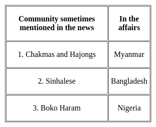
Consider the following pairs :

Which of the pairs given above is/are correctly matched?

Detailed Solution for MH SET Paper 2 Mock Test - 4 (Geography) - Question 8

The correct answer is 3 only.

Key Points

Boko Haram

  • It is the militant group in northern Nigeria that has killed tens of thousands of people and displaced more than 3 million people. Hence, Pair 3 is correctly matched.
  • Boko Haram militants mainly inhabit areas in the northern states of Nigeria, specifically Yobe, Kano, Bauchi, Borno and Kaduna.
  • Boko Haram means "Western education is forbidden." The group was founded in 2002.

Sinhalese

  • It is also spelt Singhalese or Cingalese, a member of the people of Sri Lanka (formerly Ceylon) who constitute the largest ethnic group on that island. Hence, Pair 2 is not correctly matched.
  • In the early 21st century the Sinhalese were estimated to number about 13.8 million, or 73 per cent of the population.
  • Their ancestors are believed to have come from northern India, traditionally in the 5th century BCE.
  • Their language belongs to the Indo-European family.

Chakmas and Hajongs

  • The Chakmas and Hajongs of Arunachal Pradesh are migrants from the Chittagong Hill Tracts of erstwhile East Pakistan, now Bangladesh. Hence, Pair 1 is not correctly matched.
  • Displaced by the Kaptai dam on the Karnaphuli River in the 1960s, they sought asylum in India.
  • They settled in relief camps in the southern and south-eastern parts of Arunachal Pradesh from 1964 to 1969.
  • A majority of them live in the Changlang district of the State today.
  • Mizoram and Tripura have a sizeable population of the Buddhist Chakmas while the Hindu Hajongs mostly inhabit the Garo Hills of Meghalaya and adjoining areas of Assam.
MH SET Paper 2 Mock Test - 4 (Geography) - Question 9

What fundamental principle, according to the passage, remains relevant even in the face of technological progress?

Detailed Solution for MH SET Paper 2 Mock Test - 4 (Geography) - Question 9

Option 2) Finite resources and preventive checks.

The theory highlights a fundamental principle that, despite technological progress, remains relevant in the context of population dynamics and resource sustainability. Understanding this principle is crucial to addressing the challenges associated with a growing global population.

Key Points

  • The correct answer is 2. Finite resources and preventive checks.
  • According to the theory, while technological advancements have delayed the checks on population growth predicted by Malthus, the fundamental principle of finite resources remains pertinent.
  • This means that, despite innovations, the Earth's capacity to provide essential resources like food, water, and energy is not infinite.
  • The concept of preventive checks, measures taken by individuals to control their own reproduction, is integral to maintaining a balance between population growth and the availability of resources.

Important Points

  • To elaborate further, the concept of preventive checks includes various strategies individuals employ to control population growth voluntarily.
  • These can encompass family planning, education, and social norms influencing decisions related to marriage and childbirth.
  • The idea is that proactive measures can contribute to achieving a sustainable balance between population size and available resources.
MH SET Paper 2 Mock Test - 4 (Geography) - Question 10

What is the primary assertion of the Malthusian Theory of Population?

Detailed Solution for MH SET Paper 2 Mock Test - 4 (Geography) - Question 10

Resources grow exponentially, while population grows at an arithmetic rate.

The Malthusian Theory of Population is a theory of population growth that was developed by Thomas Malthus in the late 18th century. The theory states that population growth is exponential, while the growth of resources is arithmetic. This means that population growth will eventually outstrip the growth of resources, leading to famine, disease, and other social problems.

Key Points

Resources grow exponentially, while population grows at an arithmetic rate.

  • This is the primary assertion of the Malthusian Theory of Population.
  • Malthus believed that population growth was exponential, meaning that it would increase by a fixed percentage each year.
  • He also believed that the growth of resources was arithmetic, meaning that it would increase by a fixed amount each year.
  • This meant that population growth would eventually outstrip the growth of resources, leading to famine, disease, and other social problems.
  • The Malthusian Theory of Population has been criticized by many economists and demographers.
  • However, it remains an important theory in the study of population growth

Additional Information

  • Resources and population grow at the same rate.

This is not a correct statement of the Malthusian Theory of Population. Malthus believed that population growth was exponential, while the growth of resources was arithmetic. This meant that population growth would eventually outstrip the growth of resources.

  • Population growth is exponential, and resources grow at a faster rate.

This is not a correct statement of the Malthusian Theory of Population. Malthus believed that population growth was exponential, while the growth of resources was arithmetic. This meant that population growth would eventually outstrip the growth of resources.

  • Both population and resources grow at an unpredictable rate.

This is not a correct statement of the Malthusian Theory of Population. Malthus believed that population growth was exponential, while the growth of resources was arithmetic. This meant that population growth would eventually outstrip the growth of resources.

MH SET Paper 2 Mock Test - 4 (Geography) - Question 11

Which of the following statements regarding the Mediterranean and Monsoon climate is/are correct?

1. Precipitation in the Mediterranean climate is in winter while in Monsoon climate it is mostly in summer.
2. The annual range of temperature in the Mediterranean climate is higher than the Monsoon climate.
3. Rainy and dry seasons are found in both the climates.

Select the correct answer using the code given below:
Detailed Solution for MH SET Paper 2 Mock Test - 4 (Geography) - Question 11

Correct Option- (c)

  • Mediterranean climate is known for hot, dry summers and mild to cool wet winters.
  • During the summer, cold currents keep the climate dry and when the season changes, ocean current shifts too. Hence, during the winter, the water having been warmed up in summer moves in and keep the land warn and often brings rain.
  • Hence, the annual range of temperature in the Mediterranean climate is lesser than that of Monsoon Climate.
MH SET Paper 2 Mock Test - 4 (Geography) - Question 12

Which one of the following scholars introduced the concept of Human Development?

Detailed Solution for MH SET Paper 2 Mock Test - 4 (Geography) - Question 12

The correct answer is Dr Mahabub-ul-Haq.

Key Points

  • The concept of human development was introduced by Pakistani economist Dr Mahbub-ul-Haq. Hence option 2 is correct.
  • Dr Haq has described human development as development that enlarges people’s choices and improves their lives.
  • He also created the Human Development Index in 1990.
  • According to him, development is all about enlarging people’s choices to lead long, healthy lives with dignity.
  • The United Nations Development Programme has used its concept of human development to publishing the Human Development Report annually since 1990.
MH SET Paper 2 Mock Test - 4 (Geography) - Question 13

Which of the following are true about the paradigm shift in Geography?

(A) It is a usual and accepted way of thinking about something that changes completely

(B) New paradigms brought adverse degradation of human efforts and morals

(C) Paradigm shift majorly focuses on the historical perspective

(D) Khun introduced the stages of development of a new paradigm

Choose the correct answer from the options given below:
Detailed Solution for MH SET Paper 2 Mock Test - 4 (Geography) - Question 13

Correct Answer: (A) and (D) only.

Key Points

  • The term paradigm was coined by S. Thomas Kuhn (1922-1996), an American historian of science while postulating a very important theory about the growth and development of science.
  • Distinct paradigm shifts have been taking place in both Geographical Research and Geospatial Technology through Digitalization.
  • The large growing population of the world requires a logical and scientific shift in both pure and applied research in the domain of geography.
  • Accordingly, a paradigm shift is defined as "an important change that happens when the usual way of thinking about or doing something is replaced by a new and different way."
  • The term paradigm was coined by S. Thomas Kuhn (1922-1996), an American historian of science while postulating a very important theory about the growth and development of science.
  • Kuhn (1962) defined ‘paradigm’ as the entire constellation of beliefs, values, techniques, and so on shared by the members of a given community.’
  • The Kuhn Cycle is a simple cycle of progress described by Thomas Kuhn in 1962 in his seminal work The Structure of Scientific Revolutions.
  • In Structure Kuhn challenged the world's current conception of science, which was a steady progression of the accumulation of new ideas.
  • In a brilliant series of reviews of past major scientific advances, Kuhn showed this viewpoint was wrong.
  • Science advanced the most by occasional revolutionary explosions of new knowledge, each revolution triggered by the introduction of new ways of thought so large they must be called new paradigms.

Additional Information

  • Recently, an integrating approach is a new paradigm in geography.
  • The main concern of recent geographical research is the perception of the environment, location, and geographical space.
  • The spatial dimension is an important aspect of the social epistemology geography (Science of space).
  • Consideration of space is required to understand the concept of integration and analysis of spatial patterns and processes.
  • The Geoinformatics paradigm in the 21st century is actually reflective of the concept of integration in terms of cartography, Geodesy, photogrammetry, spatial analysis, web mapping, global navigation satellite system, etc.
MH SET Paper 2 Mock Test - 4 (Geography) - Question 14

The earliest arrivals in India are believed to be Negritos. At which one of the following places are they mainly found now?

Detailed Solution for MH SET Paper 2 Mock Test - 4 (Geography) - Question 14

The earliest arrivals in India are believed to be Negritos. At Andaman Islands they are mainly found now. The Andaman Islands are home to four 'Negrito' tribes – the Great Andamanese, Onge, Jarawa and Sentinelese. The Nicobar Islands are home to two 'Mongoloid' tribes – the Shompen and Nicobarese. The 'Negrito' tribes are believed to have arrived in the islands from Africa up to 60,000 years ago.

MH SET Paper 2 Mock Test - 4 (Geography) - Question 15

Which one of the following industries would be found in the traditional industrial region?

Detailed Solution for MH SET Paper 2 Mock Test - 4 (Geography) - Question 15

Industries like Cotton Textile Industries, Iron and Steel industries, Sugar industries are characterized by higher proportion of workers in semi-skilled categories, using old obsolete technology, causing huge pollution unlike modern high tech industries. IT industries and the knowledge-based industries do not fall under traditional large-scale industries.

MH SET Paper 2 Mock Test - 4 (Geography) - Question 16
Who is the author of The Geographical Tradition (1993)?
Detailed Solution for MH SET Paper 2 Mock Test - 4 (Geography) - Question 16

Correct Answer: D.N. Livingstone.

Key Points

  • The quarter of a century since the publication of David Livingstone’s (1992) The Geographical Tradition provides an apt moment to reflect on the book’s theses, lacunae, and legacies, and to take stock of the ways in which its provocations and reception might instruct the wider project of rendering the discipline’s history.
  • In framing this themed intervention, we engage the assertion that contextualizers need contextualizing; there exists scope to heighten awareness of the location within time, space, and culture from which contextualist historiographies of geography are written. We call attention to the meaning and implications of the particular and situated contextualist methodology mobilized and executed in The Geographical Tradition.
  • The Geographical Tradition undoubtedly broke new ground in its relentless scrutiny of the reciprocal constitution of text and context and its sustained contextualist interrogation of geography, Geography, and geographers. For Withers, a key to The Geographical Tradition was Livingstone’s “insistence that we must situate geography historically and geographically”.
  • The four traditions are the Spatial or Locational Tradition, the Area Studies or Regional Tradition, the Man-Land Tradition, and the Earth Science Tradition. Each of these traditions is interrelated, and they are often used in conjunction with one another, rather than alone.

​ Additional Information

  • Livingstone detected two critical flaws in existing historiographical accounts: ‘presentism’ or interpreting past geographical ideas by the (scientific, moral, and aesthetic) standards of today, and ‘internalism’ or construing the evolution of the discipline in terms of interior drivers of change (scholarly fields, their champions, spats, alignments, and plays). Refusing to label and police the boundaries of his alternative approach too strictly, he invoked the simple yet powerful idea of 'situated messiness'.
MH SET Paper 2 Mock Test - 4 (Geography) - Question 17
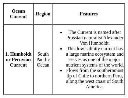
This cold ocean current is of low salinity and flows in the South Pacific region. Flowing along the west coast of South America, it acts as a major nutrient source for the marine ecosystem. Which of the following ocean currents best match with the features described above?
Detailed Solution for MH SET Paper 2 Mock Test - 4 (Geography) - Question 17

Hence Option C is the correct answer.

MH SET Paper 2 Mock Test - 4 (Geography) - Question 18
______ is an equatorial belt of low atmospheric pressure where the trade winds converge.
Detailed Solution for MH SET Paper 2 Mock Test - 4 (Geography) - Question 18

The correct answer is Doldrums.

  • Doldrums is an equatorial belt of low atmospheric pressure where the trade winds converge.

Key Points

Moraine

  • Moraines are distinct ridges or mounds of debris that are directly laid down by a moving glacier. This material is usually soil and rock.
  • Moraines only show up in places that have, or used to have glaciers.
  • Glaciers are extremely large, moving rivers of ice.
  • Glaciers shape the landscape in a process called glaciation.
  • Glaciation can affect the land, rocks, and water in an area for thousands of years. That is why moraines are often very old.

La Nina

  • La Nina is a climate pattern that describes the cooling of surface ocean waters along the tropical west coast of South America.
  • La Nina is the counterpart of El Nino.
  • La Lina means Little Girl in Spanish.
  • La Lina occurs at irregular intervals of about two to seven years.
  • La Niña is caused by a build-up of cooler-than-normal waters in the tropical Pacific, the area of the Pacific Ocean between the Tropic of Cancer and the Tropic of Capricorn.
  • Unusually strong, eastward-moving trade winds and ocean currents bring this cold water to the surface, a process known as upwelling.

El Nino

  • El Nino is a climate pattern that describes the unusual warming of surface waters in the eastern tropical Pacific Ocean.
  • El Nino means Christ child or Littel Boy in Spanish
  • During the time of El Nino, the trade winds weaken and warm water pushed back east towards the coast of Latin American countries.
  • El Nino can affect our weather significantly and trade winds.
  • El Nino has a strong effect on marine life off the Pacific coast.

Additional Information

  • Atmospheric Pressure belts are seasonally identical horizontal pressure variations created in the earth's atmosphere just above the earth's surface due to seasonal and spatial variation of energy received by the earth at different places.
  • There are seven pressure belts on the earth's surface. They are the Equatorial Low, the two Subtropical highs, the two Subpolar lows, and the two Polar highs. Except for the Equatorial low, the others form matching pairs in the Northern and Southern Hemispheres.

Equatorial Low-Pressure Belts

  • It is located on either side of the North and South of the Equator in a zone extending from 0o to 5o.
  • It is thermally induced because of the intense heating of the ground by the vertical rays of the sun.
  • It represents the zone convergence of North-East and South-East trade winds. This convergence zone is characterized by light and feeble winds and because of the frequent calm conditions, this belt is also called a belt of calm or doldrums.

Subtropical High-Pressure Belts

  • It extends between 30o to 35o both the hemisphere
  • It is not thermally induced but dynamically induced as it owes its origin to the rotation of the earth and sinking and settling down of winds.
  • Here the zone convergence of winds at a higher altitude above this zone results in the subsidence of air from higher altitudes and this wind results in high pressure. This zone of high pressure is also called the Horse latitude.
  • The permanent winds blowing from the Sub-Polar High-Pressure to Sub-Polar Low-Pressure in both the hemisphere are called Westerlies.

Sub-Polar Low-Pressure Belts

  • It extends between 60o and 65o in both the hemisphere.
  • The low-pressure belt does not thermally induce because there is low temperature throughout the year and as such there should have been a high-pressure belt instead of low pressure.
  • Pressure gradient, rotation of the earth and Coriolis force, centrifugal action of wind are the factor that controls the air motion.
  • This region is marked by violent storms in winter.

Polar High-Pressure Belts

  • Polar high pressure is very small in area and extends between 70o to 90oin both the hemisphere.
  • The temperatures are always extremely low.
  • The Polar regions experience very cold climatic conditions due to the rays of the sun is extremely slanting.
  • These regions of Polar high-pressure belts are known as the Polar Highs.
  • These regions are characterized by permanent IceCaps.

MH SET Paper 2 Mock Test - 4 (Geography) - Question 19
Given below are two statements- one is labelled as Assertion (A) and the other is labelled as Reason (R):

Assertion (A)- Red Sea has a salinity of 40 ppt.

Reason (R)- The salinity is greatly influenced by the difference between evaporation and precipitation as well as sea water movement.

Choose the correct option:

Detailed Solution for MH SET Paper 2 Mock Test - 4 (Geography) - Question 19

As we all know, the Evaporation, precipitation and some other are prime driving factors that are responsible for the spatial and regional distribution of sea and ocean water. In the partially enclosed seas of the Indian Ocean at the head of the Persian Gulf the salinity is 37ppt. whereas in the interior it amounts to 40.0ppt. The Red Sea, however, records the highest salinity among the enclosed seas because of high evaporation, less precipitation and mixture of the runoff water from the land.

MH SET Paper 2 Mock Test - 4 (Geography) - Question 20

The word ‘ecology’ (Ökologie) was coined in 1866 by :

Detailed Solution for MH SET Paper 2 Mock Test - 4 (Geography) - Question 20

The word "ecology" ("Ökologie") was coined in 1866 by the German scientist Ernst Haeckel (1834–1919).

MH SET Paper 2 Mock Test - 4 (Geography) - Question 21
Western disturbances are extratropical storms that bring sudden winter rain to the northern parts of India. They originate in ______.
Detailed Solution for MH SET Paper 2 Mock Test - 4 (Geography) - Question 21

The correct answer is the Mediterranean Sea.

Key PointsWestern disturbances are extratropical storms that bring sudden winter rain to the northern parts of India. They originate in the Mediterranean Sea

Western Disturbances

  • Western Disturbances form in the mid-latitude area, situated north of the Tropic of Cancer. This is why they are referred to as mid-latitude storms or extra-tropical storms
  • Western Disturbances are low-pressure systems, embedded in western winds (westerlies)  that flow from west to east.

Arrival in India

  • Western Disturbances begin is a low-pressure system that originates in the Mid-latitude region near the Atlantic Ocean and Europe.
  • The low pressure typically forms over the Mediterranean Sea and travels over Iran, Iraq,  Afghanistan, and Pakistan before entering India loaded with moisture.
  • These moisture-laden western disturbances eventually come up against the Himalayas and get blocked, as a consequence, the moisture gets trapped and precipitation is shared in the form of snow and rain over Northwest India and other parts of North India. 
  • An average of 4-5 western disturbances form during the winter season and the rainfall distribution and amount varies with every western disturbance.
  • The word 'Western' refers to the direction from which they originate in India.
  • The word 'disturbance' is used because the air within the low-pressure systems tends to be unstable or disturbed.
  • When western disturbances become more intense in the Indian Region, they can extend even up to 15 degrees north, resulting in rainfall up to north Maharashtra,  Gujarat, and the entire Madhya Pradesh to the south.

Impact

  • Western Disturbances are the cause of most winter and pre-monsoon season rainfall across North-West India.
  • This phenomenon is usually associated with a cloudy sky, higher night temperatures, and unusual rain.
  • It is estimated that India gets close to 5-10% of its total annual rainfall from western disturbances.
  • In winter, western winds bring moderate to heavy rain in low-lying areas and heavy snow to mountainous areas of the Indian subcontinent. 
  • India is a rain-dependent country and while the southwest monsoon covers most of India, parts of North India don’t get much rain from it.
  • These regions depend upon snow and rain from western disturbances during the winter season from November to March.
  • Precipitation during the winter season has great importance in agriculture particularly for rabi crops including wheat, which is one of the most important Indian crops.
  • They start declining after winter.
  • During the summer months of April and May, they move across North India and at times help in the activation of monsoon in certain parts of northwest India.
  • During the monsoon season, western disturbances may occasionally cause dense clouding and heavy precipitation.
  • Weak western disturbances are associated with crop failure and water problems across north India.
  • Strong western disturbances can help residents, farmers and governments avoid many of  the problems associated with water scarcity.

Additional Information

  • The Mediterranean Sea is located between Eurasia and Africa, mostly surrounded by land.
  • It shares borders with 21 countries: Albania, Algeria, Bosnia and Herzegovina, Croatia, Cyprus, Egypt, France, Greece, Israel, Italy, Lebanon, Libya, Malta, Monaco, Montenegro, Morocco, Slovenia, Spain, Syria, Tunisia, and Turkey.
  • To the west, it connects to the Atlantic Ocean via the Strait of Gibraltar.
  • To the east, it is linked to the Black Sea through the Dardanelles Straits.
  • To the south, it is connected to the Red Sea through the Suez Canal.
  • The Nile River in Africa drains into the Mediterranean Sea.

MH SET Paper 2 Mock Test - 4 (Geography) - Question 22
Which of the following is not influenced by human activities?
Detailed Solution for MH SET Paper 2 Mock Test - 4 (Geography) - Question 22

Impact of humans on the Environment:

  • Groundwater systems have considerably depleted due to human activities, including groundwater abstraction, reservoir construction, the indiscriminate exploitation of groundwater, changes in land use and intervention in natural flow patterns.
  • Mangroves have been subjected to unsustainable human activities such as deforestation led by increasing demand for land which has resulted in continued reduction in their numbers.
  • Wetlands have been deteriorating due to the effects of human activities such as alteration of the physical, chemical and biological components of wetland ecosystems, dam construction, discharge of industrial wastes and municipal sewage. These activities contribute to changes in the flood regime of wetlands and the input and cycling of nutrients.
  • Several species are at a greater risk of going extinct than before because of the destruction of their habitats by humans, hunting, changes in land use and land cover, species introduction or removals, etc.
MH SET Paper 2 Mock Test - 4 (Geography) - Question 23
Which spacecraft was used for the launch of Mangalyan (Mars Orbiter Mission) of India?
Detailed Solution for MH SET Paper 2 Mock Test - 4 (Geography) - Question 23

The Mars Orbiter Mission probe lifted off from the First Launch Pad at Satish Dhawan Space Centre (Sriharikota Range SHAR), Andhra Pradesh, using a Polar Satellite Launch Vehicle (PSLV) rocket C25 at 09:08 UTC on 5 November 2013. The launch window was approximately 20 days long and started on 28 October 2013.

Important Points

'Mangalyan' MOM:

  • Mars Orbiter Mission (MOM), the maiden interplanetary mission of ISRO, launched on November 5, 2013, by PSLV-C25 got inserted into Martian orbit on September 24, 2014, in its first attempt. 
  • Mangalyan success makes India only the fourth entity to put spacecraft in Mars orbit after the United States, the Soviet Union, and the European Space Agency.
  • India is the first Asian country to successfully place a spacecraft in orbit around Mars and the first country anywhere to do so in the first attempt.
  • Mangalyaan was India's first interplanetary mission. The indigenously-built space probe has been in the Martian orbit since September 24, 2014.
  • The mission made India the first Asian country, and the fourth in the world after Roscosmos, NASA, and the European Space Agency, to get to the planet.
  • China referred to India's successful Mangalyaan as the "Pride of Asia".

Hence, the correct answer is PSLV C-25.

MH SET Paper 2 Mock Test - 4 (Geography) - Question 24
Who postulated the paving stone hypothesis?
Detailed Solution for MH SET Paper 2 Mock Test - 4 (Geography) - Question 24

The term plate was first used by J.T. Wilson in 1965. McKenzie and Parker elaborated the mechanism behind the movement of plates in 1967. It was based on Euler’s geometrical theorem. Based on this, they gave the paving stone hypothesis. It says that oceanic crust is formed at the ridges and destroyed at the trenches. Isacks and Sykes confirmed this hypothesis in 1967.

Thus, the Correct answer is B.

MH SET Paper 2 Mock Test - 4 (Geography) - Question 25

Process of chemical weathering is represented by-

Detailed Solution for MH SET Paper 2 Mock Test - 4 (Geography) - Question 25

Chemical weathering is the weakening and subsequent disintegration of rock by chemical reactions. These reactions include oxidation, hydrolysis, and carbonation. These processes either form or destroy minerals, thus altering the nature of the rock's mineral composition

MH SET Paper 2 Mock Test - 4 (Geography) - Question 26
Which one of the following oceans is possibly the residual part of Panthalassa?
Detailed Solution for MH SET Paper 2 Mock Test - 4 (Geography) - Question 26

The correct answer is the Pacific Ocean

Key Points

  • Panthalassa was the superocean that surrounded the supercontinent Pangaea.
  • A superocean is an ocean that surrounds a supercontinent.
  • It is less commonly defined as any ocean larger than the current Pacific Ocean.
  • The movement of Earth's tectonic plates formed Pangaea and ultimately broke it apart. Pangaea existed during the Permian and Triassic geological time periods, which were times of great change.
  • Pangaea is believed to be the single land mass, around 200 million years back this landmass broke up into two land masses, that are Laurasia and Gondwanaland

Additional Information

  • Atlantic Ocean
    • It is the second-largest ocean in the world. 
    • It covers around 29% of the water's surface and 20% of the earth's surface. 
  • Pacific Ocean:
    • it is the largest of all ocean present on the earth.
    • It is bounded by the continents of America in the east and Asia and Australia in the west. 
  • Indian Ocean
    • It is the third-largest ocean in the World. 
    • It is bounded by Africa in the West, Australia in the east, and India in the north. 
  • Arctic Ocean:  
    • It is the smallest and the shallowest ocean in the world. 
    • It is found on the Nothern tip of the globe. 
MH SET Paper 2 Mock Test - 4 (Geography) - Question 27
Who questioned the philosophy of exceptionalism?
Detailed Solution for MH SET Paper 2 Mock Test - 4 (Geography) - Question 27

Schaefer questions the philosophy of exceptionalism which was advocated by Hettener and later argued by Hartshorne in his aerial differentiation. He argues for geography which is more scientific and analytical.

Thus, the Correct answer is A.

MH SET Paper 2 Mock Test - 4 (Geography) - Question 28
The practise of selling a commodity in two countries at a price that differs for reasons not related to costs is called _____?
Detailed Solution for MH SET Paper 2 Mock Test - 4 (Geography) - Question 28

The correct answer is Dumping.

Key PointsDumping

  • The practise of selling a commodity in two countries at a price that differs for reasons not related to costs is called dumping.
  • Hence the correct answer is option 2.

Additional InformationBilateral trade

  • Bilateral trade is done by two countries with each other.
  • They enter into an agreement to trade specified commodities amongst them.

Multi-lateral trade

  • As the term suggests multi-lateral trade is conducted with many trading countries.
  • The same country can trade with a number of other countries.

Barter system

  • The initial form of trade in primitive societies was the barter system, where direct exchange of goods took place.
MH SET Paper 2 Mock Test - 4 (Geography) - Question 29
A narrow passage of water connecting two large water bodies like seas and oceans is called ________.
Detailed Solution for MH SET Paper 2 Mock Test - 4 (Geography) - Question 29

The correct answer is option 4 i.e., Strait.

  • A narrow passage of water connecting two large water bodies like seas and oceans is called strait.
  • Example - Strait of Malacca.
  • A lagoon is a water body separated from larger water bodies by a natural barrier.
  • A narrow strip of land that separates two water bodies and connects two larger landmasses is known as an isthmus.
  • Example - Isthmus of Panama.
  • A broad inlet or a small water body that is set off from a larger water body where the land curves inward is known as a bay.
  • Example- Bay of Bengal.
MH SET Paper 2 Mock Test - 4 (Geography) - Question 30
Which of the following agro-climatic regions practices shifting agriculture?
Detailed Solution for MH SET Paper 2 Mock Test - 4 (Geography) - Question 30

The Eastern Himalayan region has rugged topography, steep slopes, thick forests and swift flowing rivers. The area has red brown soil and has shifting cultivation. It is called jhumming locally. Rice, maize, potato and fruits are the main crops here.

View more questions
60 tests
Information about MH SET Paper 2 Mock Test - 4 (Geography) Page
In this test you can find the Exam questions for MH SET Paper 2 Mock Test - 4 (Geography) solved & explained in the simplest way possible. Besides giving Questions and answers for MH SET Paper 2 Mock Test - 4 (Geography), EduRev gives you an ample number of Online tests for practice
Download as PDF