MAHA TET Exam  >  MAHA TET Tests  >  MH SET Mock Test Series 2025  >  MH SET Paper 2 Mock Test - 6 (Geography) - MAHA TET MCQ

MH SET Paper 2 Mock Test - 6 (Geography) - MAHA TET MCQ


Test Description

30 Questions MCQ Test MH SET Mock Test Series 2025 - MH SET Paper 2 Mock Test - 6 (Geography)

MH SET Paper 2 Mock Test - 6 (Geography) for MAHA TET 2025 is part of MH SET Mock Test Series 2025 preparation. The MH SET Paper 2 Mock Test - 6 (Geography) questions and answers have been prepared according to the MAHA TET exam syllabus.The MH SET Paper 2 Mock Test - 6 (Geography) MCQs are made for MAHA TET 2025 Exam. Find important definitions, questions, notes, meanings, examples, exercises, MCQs and online tests for MH SET Paper 2 Mock Test - 6 (Geography) below.
Solutions of MH SET Paper 2 Mock Test - 6 (Geography) questions in English are available as part of our MH SET Mock Test Series 2025 for MAHA TET & MH SET Paper 2 Mock Test - 6 (Geography) solutions in Hindi for MH SET Mock Test Series 2025 course. Download more important topics, notes, lectures and mock test series for MAHA TET Exam by signing up for free. Attempt MH SET Paper 2 Mock Test - 6 (Geography) | 100 questions in 120 minutes | Mock test for MAHA TET preparation | Free important questions MCQ to study MH SET Mock Test Series 2025 for MAHA TET Exam | Download free PDF with solutions
MH SET Paper 2 Mock Test - 6 (Geography) - Question 1

Given below are two statements. One is labelled as Assertion (A) and the other is labelled as Reason (R).The Egyptians used to call

Assertion (A): The density of oceanic water depends upon temperature and salinity.

Reason (R) : The density of water increases as the temperature increases.

Select the correct answer from options given below:

Detailed Solution for MH SET Paper 2 Mock Test - 6 (Geography) - Question 1

The density of ocean water is dependent on the temperature of water and amount of salts present in the water, i.e. salinity of water. Average density of ocean water is 1027 gm/ cc. As the salinity increases, the density of water also increases. As temperature of water increases, molecules of water move further apart, hence the density of water decreases. So, (A) is true and (R) is false.

Thus, the correct answer is C.

MH SET Paper 2 Mock Test - 6 (Geography) - Question 2

Which of these is not a type of federal state ?

Detailed Solution for MH SET Paper 2 Mock Test - 6 (Geography) - Question 2

Key Points

Federal state:

  • The federal government is a type of national government in which the government has powers to delegates the power to other elected members of the states.
  • There can be two levels of the federal government in a country either it is performing through common institutions or through powers as prescribed by a constitution of the state.
  • It is totally opposite to the unitary government.
  • In federation or federal government, provinces or territories enjoy some rights as are available to the independent states.
  • However international diplomacy, national security, foreign affairs, and other kinds of international dealings are solely made by the federal government.
  • In the federal system, power is jointly shared between the state and federal governments.
  • In the federal government system, the powers never rest with one national government.
  • However, there can be certain powers and authorities that remain totally with the federal government like policies on defence, budget, international diplomacy, etc.
  • Some of the examples are India, Pakistan, India, Brazil, Switzerland, Australia, Belgium, Canada, etc.
  • The three lists and their components are as follows,

  • It has a centralized form along with state and common responsibilities,

Therefore, Composite is not a type of federal state.

MH SET Paper 2 Mock Test - 6 (Geography) - Question 3

The concept largely developed by the Berkeley School of Thought, led by Carl o Sauer about the humanized geographical content of the region/ space is 

Detailed Solution for MH SET Paper 2 Mock Test - 6 (Geography) - Question 3

The correct answer is ​Cultural landscape.

Key Points

  • Cultural landscape studies, as geographer Carl Sauer and the ‘Berkeley School’ developed them from the 1940s on, focused on the evolution of places and included the ‘combination of natural and man-made elements that comprises, at any given time, the essential character of a place (see Landscape Architecture).
  • Cultural landscape studies emphasized the connection between natural environments and built interventions.
  • Cultural landscape methods are used to study the places, and people's shaping of them.
  • This method tends to stress the physical and not the political dimensions of places.
  • It helps in learning the rural, pre-industrial landscapes, vernacular house types, and patterns of cultivation, considering ecology but avoiding issues of political contestation.
  • The study of cultural landscape serves some very significant complementary purposes, which include the systematic description of the landforms, classification of types of culture on a regional basis, elaboration on the relationship enjoyed between nature and human beings in general and human settlements in particular, role of Human agency in alteration and modification of landscape particularly the natural landscape, inquiry into dynamics of social and cultural groups in the space. 
  • The concept of cultural landscape further elaborated and worked upon by Berkley Professor Carl O Sauer, played important role in strengthening and fueling the idea that Geography could justify itself by making landscape study its sole subject matter. 

Additional Information

  • The Berkeley School, Sauer's most famous work to come out of his time at U.C. Berkeley was his paper, "The Morphology of Landscape" in 1925.
  • Like much of his other work, it challenged environmental determinism and made clear his stance that geography should be the study of how present landscapes were shaped over time by people and natural processes.
  • Sauer organized the international conference, "Man's Role in Changing the Face of the Earth," at Princeton, New Jersey in 1955 and contributed to a book of the same title.
  • In it, he explained the ways humans have impacted the Earth's landscape, organisms, water, and atmosphere.
MH SET Paper 2 Mock Test - 6 (Geography) - Question 4
Which union territory has the lowest population in India as per the census of 2011
Detailed Solution for MH SET Paper 2 Mock Test - 6 (Geography) - Question 4

 The Union territory of Lakshadweep has total population of 64,473, which accounts for 0.01% of the total population of India according to census of 2011. The population density here is 382 persons per square km.

Thus, the correct answer is B.

MH SET Paper 2 Mock Test - 6 (Geography) - Question 5
Consider the following statements about human environment interaction and state which amongst the following is true:

i. The type of society has strong influence over the environment .

ii. Human characteristics have impact on the environment.

iii. Education is a key factor on people’s view of life.

iv. Ecosystem services are important for human well-being.

Choose the correct option from below:

Detailed Solution for MH SET Paper 2 Mock Test - 6 (Geography) - Question 5

 Human environment interaction involves understanding of human characteristics. The type of society strongly influences people’s attitude towards nature, their behavior, and therefore their impact on ecosystem. Important characteristics of human social systems are population size, social organization, values, technologies etc.

Thus, the Correct answer is D.

MH SET Paper 2 Mock Test - 6 (Geography) - Question 6

Match List I with List II:

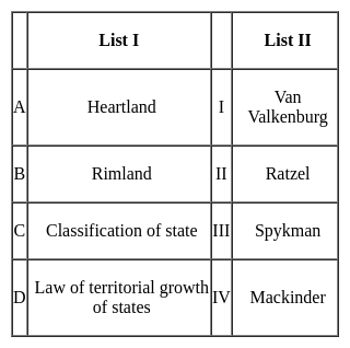
Choose the correct answer from the options given below:

Detailed Solution for MH SET Paper 2 Mock Test - 6 (Geography) - Question 6

Therefore the correct option is A-IV, B - III, C- I, D - II

MH SET Paper 2 Mock Test - 6 (Geography) - Question 7
Which of the following arrangement is in correct sequence in the case of elements of slope profile?
Detailed Solution for MH SET Paper 2 Mock Test - 6 (Geography) - Question 7

Most of the landforms have this type of arrangement. The Summital convexity is the topmost convex slope which supports waxing and the Basal concavity is the waning slope where the pediments or the weathered materials get deposited.

MH SET Paper 2 Mock Test - 6 (Geography) - Question 8

____________ predominantly acts as the agent of chemical erosion of soil.

Detailed Solution for MH SET Paper 2 Mock Test - 6 (Geography) - Question 8

Underground water predominantly acts as the agent of chemical erosion of soil.

MH SET Paper 2 Mock Test - 6 (Geography) - Question 9

Which of the following statements is correct

(1) The Oceanic crust is thinner as compared to the continental crust.

(2) Topmost layer of the Mantle is known as the Asthenosphere.

(3) The density of the outer core is higher than that of the inner core.

(4) The core is made up of heavy materials like Iron and Nickel.

Detailed Solution for MH SET Paper 2 Mock Test - 6 (Geography) - Question 9

The correct answer is 1, 2 and 4.

Key Points

  • The thickness of Oceanic crust is 5 km whereas that of Continental crust is around 30 km
  • The crust is made up of heavier rocks having a density of 3 gm/cm3
  • The asthenosphere is the uppermost portion of the Mantle which extends up to 400 km.
  • It is the main source of magma
  • The density of mantle is higher than that of crust and is equal to 3.4 gm/cm3
  • The outer core is in the liquid state while the inner core is in the solid-state
  • The density of the outer core is around 5 gm/cm3 and that of the inner core is around 13 gm/cm3
  • This layer is also known as the nife layer as it is rich in Nickel and iron.
MH SET Paper 2 Mock Test - 6 (Geography) - Question 10
Oceanic tides are the smallest on the
Detailed Solution for MH SET Paper 2 Mock Test - 6 (Geography) - Question 10
The correct answer is 8th a day of the waxing moon
Key Points
  • This is because, during this period, the Moon and Sun are at a right angle with Earth, partially canceling each other's gravitational pull on the oceans.
  • This results in less pronounced high and low tides, known as neap tides.
  • Full moon day: This is the time of the highest tides, called spring tides, due to the combined gravitational pull of the Moon and Sun aligned with Earth.
  • New moon day: Same as the full moon, neap tides do not occur on the new moon day.
  • 3rd day of the waning moon: This is not a specific timing associated with neap tides. The size of tides fluctuates throughout the lunar cycle, with neap tides occurring roughly around the first and third quarters of the moon.

Hence, we can conclude that Oceanic tides are the smallest on the 8th day of the waxing moon.

MH SET Paper 2 Mock Test - 6 (Geography) - Question 11
In July, Inter Tropical Convergence Zone (ITCZ) is located around
Detailed Solution for MH SET Paper 2 Mock Test - 6 (Geography) - Question 11

The correct answer is 20° N to 25° N latitudes.

Key Points

  • The Inter-Tropical Convergence Zone, or ITCZ, is the region that orbits Earth, near the equator, where the northern and southern hemisphere trade winds converge.
  • In January the ITCZ ​​is located at approximately 15°S.
  • In July it is situated at 20°N to 25°N.

Important Points

  • The Intertropical Convergence Zone (ITCZ) is a low-pressure area located on the equator.
  • Trade winds are found in this region.
  • So the air starts rising in this area.
  • I.T.C.Z in the month of July. 20° to 25°N.
  • It is situated in the Gangetic plain around the latitudes.
  • Sometimes called a monsoon trough, this monsoon trough encourages the development of thermal low air pressure over north and north-west India.
  • Due to the northward movement of ITCZ, the trade winds of the southern hemisphere cross the equator between 40° and 60° East longitude.
  • Under the influence of the Coriolis force, the direction of these trade winds crossing the equator becomes from southwest to northeast.
MH SET Paper 2 Mock Test - 6 (Geography) - Question 12

Given below are two statements, one is labelled as Assertion (A) and the other is labelled as Reason (R). Read the statements and choose the correct answer using the code given below.

Assertion (A) : Central Business District (CBD) of a city has high concentration of wholesale stores, offices and cultural and recreational activities.

Reason (R) : Prices and demand of real increases as distance towards CBD reduces.

Detailed Solution for MH SET Paper 2 Mock Test - 6 (Geography) - Question 12
Key Points

Assertion (A): Central Business District (CBD) of a city has a high concentration of wholesale stores, offices, and cultural and recreational activities.

The concept of CBD:

  • The term Central Business District (CBD) is a widely used term in commercial real estate and is defined as the functional area of a city that has the maximum concentration of commercial, retail, and business centers.
  • Geographically, it coincides with the city center and is the focal point for the transportation networks of the city.
  • It has maximum urban density than other districts of the town and offers a healthy environment for carrying out various commercial activities.
  • Today, CBDs are a diverse region in metro cities that not only include retail spaces, commercial, offices, financial institutions, government centres, and medical centres, but also entertainment hubs, restaurants, hotels, and residential area

Hence, the assertion is correct.

Reason (R): Prices and demand of real increases as distance towards CBD reduces.

Price and demand relationship:

  • In ancient times, CBDs were the market squares where merchants and customers gathered to sell and buy things.
  • However, as cities evolved, land scarcity and increasing demand reduced horizontal expansions and gave way to vertical developments.
  • The relationship of land price and distance to CBD is significant and negative, which means indicating the decreasing of land price by increasing distance from the CBD.
  • Market price gives the same result as the appraised price which is the effect of distance on land values is significant and negative.

Hence, the reason is also correct.

Therefore, Both (A) and (R) are true and (R) is the correct explanation of (A).

MH SET Paper 2 Mock Test - 6 (Geography) - Question 13
Consider the following statements:-

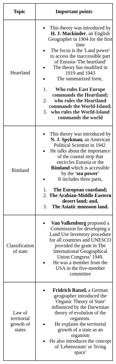
a) The Geographical Pivot of History was written by Sir Halford Mackinder in the year 1904

b) According to Spykman, aerial mobility is the new type of geopolitical structure.

Which of the following options are correct?

Detailed Solution for MH SET Paper 2 Mock Test - 6 (Geography) - Question 13

Mackinder presented his model, ' The Geographical Pivot of History' in front of the Royal Geographical Society in London in 1904. This model was developed during a period when Britain was losing her political and economic significance to the world economy.

Maritime mobility, according to Spykman, was the fundamental fact that was responsible for the development of the world politics. The development of ocean navigation and sea routes to various parts of the world has led a new structure of great power and enormous extent.

MH SET Paper 2 Mock Test - 6 (Geography) - Question 14

Which of the following options is Incorrect?

Detailed Solution for MH SET Paper 2 Mock Test - 6 (Geography) - Question 14

Option 3) ​Humboldt was greatly influenced by the Darwin's theory of  ‘struggle and natural selection'.

Additional Information

  •  The first volume of Ratzel's  work Anthropogeographie was published in 1882:  The first volume of Ratzel's monumental work Anthropogeographie was published in 1882. Through his work he initiated the idea that cultural and natural phenomenon can be subjected to systematic study. In the modified second volume (1891) he discusses the significance of the historical development and cultural background of the population.
  • Ratzel wrote 'Political Geography' in which he compared 'State' to an organism:  In 1896 Ratzel wrote 'Political Geography' in which he compared 'State' to an organism. He stressed that a state, like a few simple creatures, should either grow or die or cannot stand anytime. This was the philosophy of 'living place', which created a controversy over the superior and the low levels, which advocates saying that the best people (nations) have to stay 'at the expense of neighbouring countries
  • Humboldt was greatly influenced by the Darwin's theory of  ‘struggle and natural selection':  Being contemporary of Darwin, Ratzel was influenced by the Darwin's theory of species especially the themes of ‘struggle and natural selection’ and ‘association and organisation’. It was Ratzel, who compared the mode of life of different tribes and nations, and thus made a systematic study of human geography.
  • Hettner was against environmental determinism and he appeared to be a significant contributor to the doctrine of possibilism: Hettner  a significant contributor to the doctrine of possibilism. He even rejected the idea that geography could be either idiographic or nomothetic but not both. His ideas of organization in geographical studies influenced the German geography for decade.
MH SET Paper 2 Mock Test - 6 (Geography) - Question 15
As per the census of 2011, what is the annual growth rate in population of India from 2001 to 2011?
Detailed Solution for MH SET Paper 2 Mock Test - 6 (Geography) - Question 15
The correct answer is 1.64 percent.Key PointsThe annual population growth rate of India according to Census 2011 is 1.64 percent.Growth of population is the change in the number of people living in a particular area between two points of time. Its rate is expressed in percentage. The Census was first started under British Viceroy Lord Mayo in 1872. It helped in framing new policies, government programs to uplift areas of improvement in the community.First synchronized census in India took place in 1881. Since 1901, it has been taking place after every decade.Census 2011 is the 15th Census, and 7th after Independence.The slogan of census 2011 is “Our Census, Our Future”.According to the Census 2011, there are 53 (million-plus) cities in India as compared to 35 on census 2001.The 15th Census of India was conducted in 2011.Additional InformationKEY POINT OF CENSUS OF INDIA 2011 Total Population of India – 1,21,08,54,977Sex Ratio (females per 1000 males) – 943Density – 382 persons per sq. kmInfant Mortality Rate (2006) – 57 per 1000 live birthsMaternal Mortality Rate – 407 per lakh live birthsLiteracy Rate of the country – 74.04%Highest literacy – Kerala (94%)Lowest literacy – Bihar ( 61.8%)Highest female literacy – Kerala (92.1 %)Lowest female literacy – Rajasthan (57.6%)Highest Population – Uttar Pradesh (19,98,12,341)Lowest Population – Sikkim ( 6,10,577)Highest Population Density – Bihar (1106)Lowest Population Density – Arunachal Pradesh (17)Highest Sex Ratio – Kerala (1084)State having lowest Sex Ratio – Haryana (879)Life Expectancy at Birth – 66.1 years, Male – 64.6 years and Female – 67.7 years.Decadal growth rate in Population – 17.7%Highest SC population is in UP.Highest ST population is in Madhya Pradesh.
MH SET Paper 2 Mock Test - 6 (Geography) - Question 16
Which of the following option is correct in the case of fronts and frontogenesis?
Detailed Solution for MH SET Paper 2 Mock Test - 6 (Geography) - Question 16

The term Frontogenesis was first used by Tor Bergeron for the creation of new fronts. Later, it was extended to include the process of regeneration of old and decaying fronts. The term is a Latin derived term. Frontogenesis occurs when the wind blows in such a way that the isotherms become packed along the leading edge of the intruding air mass.

Generally, the isobars in an air mass are smooth curves and there are no sharp bends in them. And frontal activity is always associated with cloudiness and precipitation. Since warm air moves up along the frontal surface, it cools adiabatically and thus results in cloudy condensation and precipitation.

The appearance of warm front is mostly observed by the presence of cirrus clouds.

MH SET Paper 2 Mock Test - 6 (Geography) - Question 17
Why was Political Geography termed as the 'wayward child of geographical sciences'?
Detailed Solution for MH SET Paper 2 Mock Test - 6 (Geography) - Question 17

Political Geography was termed as the wayward child of geographical sciences during the 1920s. The State-scale analysis had always been a major component of the Political Geography. It was being taught in the universities, but there was a lack of research to back up the teaching.

MH SET Paper 2 Mock Test - 6 (Geography) - Question 18

After which period the political geography came into limelight?

Detailed Solution for MH SET Paper 2 Mock Test - 6 (Geography) - Question 18

Political Geography started to prosper during the 1980s. Two research areas dominated this field. Firstly, the urban conflicts and the location of 'goods' and 'bads'; secondly, the application of the concepts of electoral geography. These were identified during the 1970s and slowly this sub discipline grew because of its remarkable resurgence.

MH SET Paper 2 Mock Test - 6 (Geography) - Question 19
Which of the following option is correct regarding Penck’s Theory?
Detailed Solution for MH SET Paper 2 Mock Test - 6 (Geography) - Question 19

The German Geomorphologist, Walther Penck proposed that the geomorphic forms are an expression of the phase and rate of uplift and in relation to the rate of degradation or erosion. This explains that the interaction between upliftment and degradation are always coexistent. These are the basic premises of the Penckian model. Accordingly, Primarumpf is referred to as the formation which can be seen before the stage of upliftment. Similarly, just like the other theories, after continued upliftment and erosional factors, the landscape gets reduced to the low plain known as endrumpf. This theory contrasts with the Davisian cycle of erosion.

MH SET Paper 2 Mock Test - 6 (Geography) - Question 20
Rainwater Harvesting is an effective technique to-
Detailed Solution for MH SET Paper 2 Mock Test - 6 (Geography) - Question 20

The Rainwater Harvesting involves the collection and storage of rainwater at surface or sub-surface aquifers and is a very useful method, particularly for developing countries like India. The above sentences are some of the needs and advantages of rainwater Harvesting and is necessary in areas where ground water levels are declining on regular basis and inadequate.

MH SET Paper 2 Mock Test - 6 (Geography) - Question 21
Read the following statements and select the correct answer from the code given below:

(a) The satellite towns are a part of the main city’s municipal corporation.

(b) The satellite towns develop beyond city’s green belt.

(c) The satellite towns are totally dependent upon the main city area.

(d) The satellite towns are separated from the main city physically by a geographical barrier like river.

Code:

Detailed Solution for MH SET Paper 2 Mock Test - 6 (Geography) - Question 21

The Satellite towns have a working administrative body of their own, generally municipalities. These towns have at least partial social and economic independence, but commute to city for is common. These areas develop beyond city’s green belt and have a geographical barrier like river which separated the satellite town as a separate, but somewhat dependent entity from the main city.

Thus, the correct answer is C.

MH SET Paper 2 Mock Test - 6 (Geography) - Question 22
Consider the following statement about Paris agreement:

i. Paris Agreement is known to combat climate change.

ii. Agreement aimed at global green house gas emission reduction.

iii. The conference held in 2015

Choose the correct option from below:

Detailed Solution for MH SET Paper 2 Mock Test - 6 (Geography) - Question 22

 Paris agreement is an international agreement to control climate change. From 30 November to 11 November 2015, over 195 nation governments gathered in Paris, France and discussed a possible new global agreement on climate change aimed at reducing global green house gas emission. It is a 32 page agreement with 29 articles widely recognized as a historic deal to stop global warming.

MH SET Paper 2 Mock Test - 6 (Geography) - Question 23
Which one of the following kinds of towns was not planned and developed during the British Rule in India?
Detailed Solution for MH SET Paper 2 Mock Test - 6 (Geography) - Question 23

Cantonment Towns

  • The nature of the colonial city changed further in the mid-nineteenth century. After the Revolt of 1857 British attitudes in India were shaped by a constant fear of rebellion. They felt that towns needed to be better defended, and white people had to live in more secure and segregated enclaves, away from the threat of the “natives ”.
  • Pasturelands and agricultural fields around the older towns were cleared, and new urban spaces called “Civil Lines” were set up. White people began to live in the Civil Lines.
  • Cantonments– places where Indian troops under European command were stationed – were also developed as safe enclaves. These areas were separate from but attached to the Indian towns. With broad streets, bungalows set amidst large gardens, barracks, parade ground and church, they were meant as a safe haven for Europeans as well as a model of ordered urban life in contrast to the densely built up Indian towns.

Railway Colonies

  • The introduction of railways in 1853 meant a change in the fortunes of towns. Economic activity gradually shifted away from traditional towns which were located along old routes and rivers. Every railway station became a collection depot for raw materials and a distribution point for imported goods.
  • With the expansion of the railway network, railway workshops and railway colonies were established. Railway towns like Jamalpur, Waltair and Bareilly developed.

Hill Stations

  • As in the case of cantonments, hill stations were a distinctive feature of colonial urban development. The founding and settling of hill stations was initially connected with the needs of the British army.
  • Simla (present-day Shimla) was founded during the course of the Gurkha War (1815-16); the Anglo-Maratha War of 1818 led to British interest in Mount Abu; and Darjeeling was wrested from the rulers of Sikkim in 1835.
  • Hill stations became strategic places for billeting troops, guarding frontiers and launching campaigns against enemy rulers.
MH SET Paper 2 Mock Test - 6 (Geography) - Question 24
Which of the following are the main Objectives of the Agro-climatic zones?

a) To optimise agricultural production

b) To increase farm income

c) To generate more employment

Choose the correct option:

Detailed Solution for MH SET Paper 2 Mock Test - 6 (Geography) - Question 24

All three options are the primary objectives of the Agro-climatic regions. However, according to the Planning Commission of India, the primary objective of the Agro-climatic regions is:- 1. maximise the net income of the producers, 2. attempt a broad demand-supply balance of major commodities at the national level, 3. provide a framework for scientific and sustainable use of natural resources, particularly land, water and forests in the long run.

MH SET Paper 2 Mock Test - 6 (Geography) - Question 25
Pick the name of the scholar/scholars well known for their work of Quantitative Revolution in the branches of Geomorphology.
Detailed Solution for MH SET Paper 2 Mock Test - 6 (Geography) - Question 25

Correct Answer: All of the above.

Key Points

  • In the 1950s and 1960s, a revolutionary change described as "quantitative revolution" occurred in the discipline of geography.
  • It replaced the ‘idiographic’ approach based on areal differentiation with a ‘nomothetic’ one, which had its roots in the search for models of spatial structure and phenomenon.
  • The quantitative revolution led to the basis of geography as a spatial science that dealt with the spatial analysis of phenomena that existed on the earth’s surface
  • Quantitative Revolution in the branches of Geomorphology and Climatology Strahler claimed that Gilbert’s paper was apter than Davis’s work; then what was the reason that it was not accepted as a signpost in geomorphology for future work; rather it has been forgotten and neglected for nearly thirty years.
  • The answer is with Strahler himself who opines that thinks that geomorphology was a part of geography.
  • The physical geographers did not adopt these ideas rather they followed Davis.
  • Some of the prominent followers of Davis include Douglas Johnson, C A. Cotton, N. M Fenneman, and A.K. Lobeck. 
  • Strahler finally states these geographers made an "excellent contribution to descriptive and regional geomorphology" and have provided a solid foundation for study in "human geography", but did not lay the basis for scientific study within geographical thinking. 

Additional Information

  • The term ‘Quantitative Revolution’ was coined by Burton in 1963. Quantitative Revolution was developed in Geography by B.J.L Berry and Richard Chorley.
  • Quantitative Revolution calls for a change in methodology, thereby imparting a scientific character to the discipline, the methodology included Mathematical tools, Statistical Analysis, Laws of Physics, etc which provided objectivity and Scientific touch, as was desired by some Geographers.
MH SET Paper 2 Mock Test - 6 (Geography) - Question 26

Consider the following statements:-

a) Davis along with erosional processes also stressed on biological processes as a contributing factor.

b) Davis’ cycle of erosion is the most widely accepted theory and is also applicable in numerous approaches of landform development.

c) According to Penck, development of landscape is not time dependent.

d) The Youthful stage of Davisian cycle of erosion is characterized by vertical erosion and valley deepening.

Which of the following statement is correct?

Detailed Solution for MH SET Paper 2 Mock Test - 6 (Geography) - Question 26

The last two sentences do suggest correct explanation of the theory of geomorphic cycle. Davis neglected the biological processes completely. The cycle of erosion by Davis is not a widely accepted theory as the theory has a descriptive simplicity and is just a generalization useful only at the base level. Moreover, it is a deductive approach.

MH SET Paper 2 Mock Test - 6 (Geography) - Question 27

Match the following mining regions for which it is famous for :


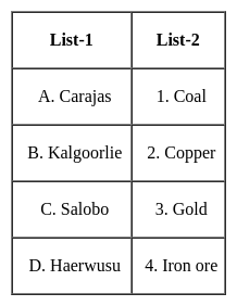
Select the correct code :
Detailed Solution for MH SET Paper 2 Mock Test - 6 (Geography) - Question 27

The correct answer is Option 4.

Key Points

The Carajas Mine

  • It is the largest iron ore mine in the world.
  • It is located in the Carajás Mountains of Northern Brazil.
  • The mine is operated as an open-pit mine and is estimated to contain roughly 7.2 billion metric tonnes of iron ore, plus gold, manganese, bauxite, copper, and nickel.
  • The mine is largely powered by hydroelectric power from the Tucuruí Dam.

Kalgoorlie mine

  • ​It is also known as the Fimiston Open Pit, colloquially known as the Super Pit, which was Australia's largest open-cut gold mine until 2016 when it was surpassed by the Newmont Boddington gold mine also in Western Australia.
  • The Super Pit is located off the Goldfields Highway on the southeast edge of Kalgoorlie, Western Australia.
  • The gold mining area of Kalgoorlie-Boulder-Fimiston has long been called the Golden Mile because of the geographical concentration of rich mines in that area.

Salobo mine

  • It is the largest copper deposit ever discovered in Brazil.
  • It is the open pit mine.
  • Salobo is an iron-oxide copper-gold (IOCG) deposit located along the southern margin of the Amazon Basin, within the Carajás Mining District, in south-eastern Para, Brazil.
  • The mineralization at the Salobo deposit is found hosted in metamorphosed rocks.

Haerwusu mine

  • With estimated recoverable coal reserves of more than 1.7 billion tonnes, the Haerwusu Coal Mine is located in the Inner Mongolia Autonomous Region of China.
  • Production from the mine was started in October 2008 and is also a major open-cast coal mine in China.
MH SET Paper 2 Mock Test - 6 (Geography) - Question 28
The swamp forests of India are found in delta of
Detailed Solution for MH SET Paper 2 Mock Test - 6 (Geography) - Question 28

The swamp forests are found in and around deltas, estuaries and creeks. In India, they are confined to deltas of Ganga, Mahanadi, Godavari, Krishna and Cauvery. The can survive in fresh as well as brackish waters. The most prominent example is Sunderban forest in the delta of Ganga River.

MH SET Paper 2 Mock Test - 6 (Geography) - Question 29
Hadley Cell is related to which of the following :
Detailed Solution for MH SET Paper 2 Mock Test - 6 (Geography) - Question 29

Concept:

Wind:

  • The movement of air from high-pressure areas to low-pressure areas is called wind.
  • Earth has five main wind zone: polar easterlies, westerlies, horse latitudes, trade winds, and the doldrums.

Atmosphere pressure:

  • The atmospheric pressure is the weight of a column of air contained in a unit area from the mean sea level to the top of the atmosphere.
  • The atmospheric pressure is expressed in units of a millibar.

Explanation:

Hadley Cell:

  • It was coined by George Hadley.
  • It is a pattern of air or wind circulation near the equatorial area.
  • Down below near the land surface the air flows towards the equator as the easterlies.
  • The easterlies from either side of the equator converge in the Inter Tropical Convergence Zone (ITCZ).
  • Such circulations from the surface upwards and vice-versa are called cells.
  • Such a cell in the tropics is called Hadley Cell.

Thus, Hadley Cell is related to the wind system.

Additional Information

Earthquake zone:

  • Earthquakes are caused by the movement of plates, the boundaries of the plates are the weak zones where earthquakes are more likely to occur.
  • The weak zones are also known as seismic or fault zones.

Volcano activity:

  • Volcanic activity can range from gas emissions to non-explosive lava eruptions to extremely violent explosive bursts that can last for hours.

Formation of the tide:

  • High and low tides are caused by the moon's gravitational pull on the Earth and the Earth's rotational force.
MH SET Paper 2 Mock Test - 6 (Geography) - Question 30

Which of the following maps are drawn to register the ownership of landed property by demarcating the boundaries of fields and building etc.?

Detailed Solution for MH SET Paper 2 Mock Test - 6 (Geography) - Question 30

Cadastral Maps. Cadastre is a technical term for a st of records showing the extent, value and ownership (or other basis for use or occupancy) of land. Strictly speaking, a cadastre is a record of areas and values of land and of landholders that originally was compiled for purposes of taxation.

View more questions
60 tests
Information about MH SET Paper 2 Mock Test - 6 (Geography) Page
In this test you can find the Exam questions for MH SET Paper 2 Mock Test - 6 (Geography) solved & explained in the simplest way possible. Besides giving Questions and answers for MH SET Paper 2 Mock Test - 6 (Geography), EduRev gives you an ample number of Online tests for practice
Download as PDF