MAHA TET Exam  >  MAHA TET Tests  >  MH SET Mock Test Series 2025  >  MH SET Paper 2 Mock Test - 9 (Geography) - MAHA TET MCQ

MH SET Paper 2 Mock Test - 9 (Geography) - MAHA TET MCQ


Test Description

30 Questions MCQ Test MH SET Mock Test Series 2025 - MH SET Paper 2 Mock Test - 9 (Geography)

MH SET Paper 2 Mock Test - 9 (Geography) for MAHA TET 2025 is part of MH SET Mock Test Series 2025 preparation. The MH SET Paper 2 Mock Test - 9 (Geography) questions and answers have been prepared according to the MAHA TET exam syllabus.The MH SET Paper 2 Mock Test - 9 (Geography) MCQs are made for MAHA TET 2025 Exam. Find important definitions, questions, notes, meanings, examples, exercises, MCQs and online tests for MH SET Paper 2 Mock Test - 9 (Geography) below.
Solutions of MH SET Paper 2 Mock Test - 9 (Geography) questions in English are available as part of our MH SET Mock Test Series 2025 for MAHA TET & MH SET Paper 2 Mock Test - 9 (Geography) solutions in Hindi for MH SET Mock Test Series 2025 course. Download more important topics, notes, lectures and mock test series for MAHA TET Exam by signing up for free. Attempt MH SET Paper 2 Mock Test - 9 (Geography) | 100 questions in 120 minutes | Mock test for MAHA TET preparation | Free important questions MCQ to study MH SET Mock Test Series 2025 for MAHA TET Exam | Download free PDF with solutions
MH SET Paper 2 Mock Test - 9 (Geography) - Question 1

Consider the following:

1. Proximity of the jute-producing areas

2. Inexpensive water transport

3. Availability of economical labor

4. Abundant water for processing raw jute

How many of the above are responsible factors for the location of the Jute industry in the Hugli basin?

How many of the statements given above are correct?

Detailed Solution for MH SET Paper 2 Mock Test - 9 (Geography) - Question 1

The correct answer is All fourKey PointsJute industry:

  • India is the largest producer of jute followed by Bangladesh and China.
  • However, in terms of acreage and trade, Bangladesh takes the lead accounting for three-fourths of the global jute exports in comparison to India’s 7%.
  • Major jute-producing states include West Bengal, Bihar, Odisha, Assam, Andhra Pradesh, Meghalaya and Tripura.
  • It is known as the golden fibre.
  • It is used in making gunny bags, mats, ropes, yarn, carpets and other artefacts.
  • The factors behind the present localization of the jute industry in Eastern India especially West Bengal are:
    • Raw material: West Bengal is the largest producer of jute and most mills are located there;
    • Water supply: High rainfall and the presence of rivers ensure abundant water for processing raw jute;
    • Easy Transportation: The region is well connected by a good network of railways, waterways, and roadways to facilitate the movement of raw materials to the mills.
    • Inexpensive water transport is also provided by the Hugli river;
    • Labour: Availability of economical labour from West Bengal and the adjoining States of Bihar, Orissa, and Uttar Pradesh;
    • Kolkata as a port and large urban centre, provides banking, insurance, and port facilities for the export of jute goods. Hence, statements 1, 2, 3 and 4 are correct.
MH SET Paper 2 Mock Test - 9 (Geography) - Question 2

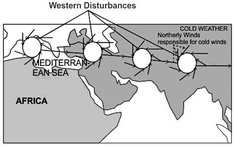
During the cold weather season, in the northern plains, there will be an inflow of cyclonic disturbances from the ______ directions.

Detailed Solution for MH SET Paper 2 Mock Test - 9 (Geography) - Question 2

The Correct Answer is West and Northwest.

Key Points

  • Western Disturbances
    • Western Disturbances begin is a low-pressure system that originates in the Mid-latitude region near the Atlantic Ocean and Europe.
  • Western Disturbances develop in the mid-latitude region (north of the Tropic of Cancer), not in the tropical region, therefore they are called mid-latitude storms or extra-tropical storms
  • A characteristic feature of the cold weather season over the northern plains is the inflow of cyclonic disturbances from the west and the northwest.
  • These low-pressure systems, originate over the Mediterranean Sea and western Asia and move into India, along with the westerly flow.
  • They cause much-needed winter rains over the plains and snowfall in the mountains.

Additional Information

  • The low pressure typically forms over the Mediterranean Sea and travels over Iran, Iraq, Afghanistan, and Pakistan before entering India loaded with moisture.
  • This disturbance is usually associated with a cloudy sky, higher night temperatures, and unusual rain.
  • These moisture-laden western disturbances eventually come up against the Himalayas and get blocked, as a consequence, the moisture gets trapped and precipitation is shared in the form of snow and rain over Northwest India and sometimes, other parts of North India.
  • The rainfall during the winter season helps agriculture, particularly for rabi crops including wheat, which is one of the most important Indian crops.
MH SET Paper 2 Mock Test - 9 (Geography) - Question 3

Which of the following is/are example(s) of the assertion that cultural differences existing in the world is the outcome of human interaction with the environment?

(A) People of Amazon basin live in houses with a steeply slanting roof.

(B) People of Amazon practice 'slash and burn agriculture'.

(C) People in Bihar and Assam make handicrafts from silk.

Detailed Solution for MH SET Paper 2 Mock Test - 9 (Geography) - Question 3

The correct answer is: All (A), (B), and (C)
Important Points

All of the given examples demonstrate how cultural differences can be attributed to human interaction with the environment:

(A) People of the Amazon basin live in houses with a steeply slanting roof.

  • This architectural style is influenced by the heavy rainfall in the region.
  • The steeply slanting roofs help to quickly shed water and prevent it from accumulating on the roof.

(B) People of the Amazon practice 'slash and burn agriculture'.

  • This farming method involves cutting down and burning vegetation to clear land for cultivation.
  • It is adapted to the environment of the Amazon rainforest, where the soil is nutrient-poor.
  • The ashes from the burning provide temporary fertility for crops.

(C) People in Bihar and Assam make handicrafts from silk.

  • The availability of silk-producing insects such as silkworms in these regions has led to the development of silk-based handicrafts.
  • The local environment provides the necessary resources for silk production and encourages the development of related cultural practices.

Therefore, all of the given examples illustrate how cultural differences are influenced by human interactions with the environment.

MH SET Paper 2 Mock Test - 9 (Geography) - Question 4
Which of the following industries is NOT a significant contributor to the economy of Bihar?
Detailed Solution for MH SET Paper 2 Mock Test - 9 (Geography) - Question 4

The correct answer is Automobile Manufacturing

Key Points

  • Bihar, an eastern state of India, has a diverse economy with several key industries. Agriculture is a major sector, with a significant portion of the population engaged in farming. The state is a major producer of crops like rice, wheat, and maize.
  • The food processing industry is another major contributor, closely linked with agriculture. It involves the processing of fruits, vegetables, dairy products, meat, and grains, adding value to agricultural produce and creating employment opportunities.
  • The textile industry, particularly silk and cotton, is also significant in Bihar. The state is known for its Bhagalpuri silk, and the textile industry provides employment to a large number of people and contributes to the state's exports.
MH SET Paper 2 Mock Test - 9 (Geography) - Question 5

In manufacturing industries of India, a micro enterprise is an enterprise where investment in plant and machinery does not exceed ____?

Detailed Solution for MH SET Paper 2 Mock Test - 9 (Geography) - Question 5

In manufacturing industries of India, a micro enterprise is an enterprise where investment in plant and machinery does not exceed Rs. 25 Lakh.

MH SET Paper 2 Mock Test - 9 (Geography) - Question 6
One of the purposes of this sampling technique is to ensure that all sections of the population are adequately represented. Identify the Sampling technique:-
Detailed Solution for MH SET Paper 2 Mock Test - 9 (Geography) - Question 6

Stratified Sampling is the only technique where all the sections of the population or sub-population are homogenously and adequately represented. Stratified sampling is generally used when the population is heterogenous but can be subdivided into strata within each of which the heterogeneity is not so prominent. If a proper stratification can be made such that the strata differ from one another as much as possible, but there is much homogeneity within each of them , then stratified sample will yield better results. Here the sub-sample sizes are made proportional to the sub population sizes.

Thus, the Correct answer is B.

MH SET Paper 2 Mock Test - 9 (Geography) - Question 7
Pairs of world species and their habitats are presented. Tell the wrong pair
Detailed Solution for MH SET Paper 2 Mock Test - 9 (Geography) - Question 7

The Correct Answer is Sakai - Siberia

Key Points

  • Pygmy - Congo Basin
    • The African Pygmies (or Congo Pygmies, variously also Central African foragers, "African rainforest hunter-gatherers" (RHG) or "Forest People of Central Africa") are a group of ethnicities native to Central Africa, mostly the Congo Basin style traditionally subsisting on a forager and hunter-gatherer lifestyle.
  • Badu-Saudi Arab.
    • With General, the Bedouin were no longer seen as an archaic race towering over a linear hierarchy of Arab races, but as stylea foreign race style whose presence in Palestine represented a sad chapter of racial assimilation in the unfolding history of conquests.
  • Eskimo
    • Eskimo is an exonym used to refer to two closely related Indigenous peoples: the Inuit and the Yupik of eastern Siberia and Alaska.
    • A related third group, the Aleut, which inhabit the Aleutian Islands, are generally excluded from the definition of Eskimo.

Additional Information

The Major Divisions of the Human Race

  • Most anthropologists recognize 3 or 4 basic races of man in existence today
    • The ethnographic division into races from Meyers Konversationslexikon of 1885-90 is listed: Caucasian races (Aryans, Hamites, Semites) Mongolian races (northern Mongolian, Chinese and Indo-Chinese, Japanese and Korean, Tibetan, Malayan, Polynesian, Maori, Micronesian, Eskimo, American Indian),
    • Negroid races (African, Hottentots, Melanesians/Papua,
    • “Negrito”, Australian Aborigine, Dravidians, Sinhalese).
MH SET Paper 2 Mock Test - 9 (Geography) - Question 8
The empirical relationship among the three measures of central tendencies is
Detailed Solution for MH SET Paper 2 Mock Test - 9 (Geography) - Question 8

Concept

The relationship between mean, median and mode is called empirical relationship. It is defines as :

Mean - Mode = 3(Mean - Median)

Calculation

Mean - Mode = 3(Mean - Median)

⇒ Mean - Mode = 3 Mean - 3 Median

⇒ 3 Median - Mode = 3 Mean - Mean

⇒ 3 Median = 2 Mean + Mode

∴ 3 Median = Mode + 2 Mean

MH SET Paper 2 Mock Test - 9 (Geography) - Question 9
As per the census 2011, what is the total Literacy rate of male population?
Detailed Solution for MH SET Paper 2 Mock Test - 9 (Geography) - Question 9

The correct answer is 82.14 %.

About Literacy rate:

  • As per the census 2011, The total literacy rate of the Males population is 82.14 % and the females' population is 65.46 % in India.
  • The definition of Literacy rate is the Total Number of Literate persons in a given Age Group, as the Percentage of the Total Population in that Age group. For example, The Youth Literacy rate measures Literacy among persons Aged 15 to 24 years, and the Adult Literacy Rate measures Literacy among persons Aged 15 years and above.

Key Points

About India Statistical data:

All the data are in the table as per the census 2011.

Note: Now India has 28 states and 8 union territories.

Graphical Representation image of The Literacy rate in India (census,2011):

Note:- Draupadi Murmu (Current President of India):- from 25 July 2022 to Still.

MH SET Paper 2 Mock Test - 9 (Geography) - Question 10
According to the Global Climate Risk Index of 2020 India is at which place ?
Detailed Solution for MH SET Paper 2 Mock Test - 9 (Geography) - Question 10

According to the Global Climate Risk Index of 2020, published by German Watch, a think tank on North-South equity and preservation of livelihoods, India is the 5th most vulnerable country to climate change impacts. India’s increasing vulnerability is due to severe rainfall, heavy flooding and landslide.

Thus, the Correct answer is B.

MH SET Paper 2 Mock Test - 9 (Geography) - Question 11
Which of the following statements are true?

(a) The western coast of Mahrashtra is the region most prone to cyclonic storms.

(b) The river Chambal in the North Indian plain is susceptible to frequent flooding.

(c) The north-eastern states lie in the earthquake prone region.

(d) The eastern coast of India has most vulnerability to cyclones.

Detailed Solution for MH SET Paper 2 Mock Test - 9 (Geography) - Question 11

 The eastern coast of India has always been prone to cyclonic storms. The major ones include like Fani and Gaja most recently. Western coast of Mahrashtra on the other hand does not have much vulnerability to cyclones. The coastline of Gujarat is more vulnerable to cyclones. The north-eastern states lie in the Arkan Yoma mountain range and has had earthquakes like Tura(8.7-1897) and Cachar(7.5-1869) and more recently, on India-Nepal Border near Sikkim(7.1-2011). The river Chambal in North-Indian plains is not susceptible to floods on a frequent basis.

Thus, the correct answer is D.

MH SET Paper 2 Mock Test - 9 (Geography) - Question 12

Match List-I with List-II

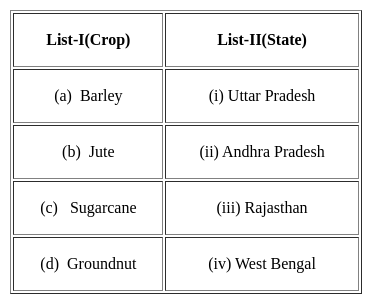
Select the correct answer from the options given below:

Detailed Solution for MH SET Paper 2 Mock Test - 9 (Geography) - Question 12
  • The largest producer of Barley in the country is Rajasthan. It produces nearly 40% of the total production. Tonk, Sawai Madhopur, Bharatpur are major Barley producing region of the Rajasthan.
  • West Bengal is the largest producer of jute. It produces three-fourths of the total jute of the country and has two-third of the total area under jute production.
  • Uttar Pradesh is the largest producer of sugar cane In India. It accounts for 36% of the total production and has nearly 43% of the total area in sugar cane production.
  • Andhra Pradesh leads in the production of groundnut. It produces nearly 23%of the total production of India. Chitoor, Kunoor and Anantapur districts are the districts which have groundnut.
MH SET Paper 2 Mock Test - 9 (Geography) - Question 13
Which of the following are not correct about Neo-Determinism?
Detailed Solution for MH SET Paper 2 Mock Test - 9 (Geography) - Question 13
Neo-Determinism
  • Australian geographer Griffith Taylor, in 1920 argued that the limit of agricultural settlements in Australia has been set by factors of the physical environment such as a distribution of rainfall. He further said that the best economic programme for a country to follow has in large part been determined by nature, and it is the geographer’s duty to interpret this programme.
  • Man is able to accelerate, slow, or stop the progress of a country’s regional development. But he should not, if he is wise, depart from directions as indicated by natural environment. He is like the traffic controller in a large city who alters the rate but not the direction of progress.
  • This theory is also called ‘’stop and go determinism’’.
  • It says that man follows nature’s plan only if he is wise, presuming he can act foolishly, which admits the possible contention that within broad limits set by the environment, man can choose at the very least. But wisdom and folly are human concepts. Nature knows nothing about them.
  • This theory says that in no environment are the possibilities limitless and for every choice a price must be paid. Man makes his choice and man himself judges its relative wisdom or folly by reference to goals he himself has established.
MH SET Paper 2 Mock Test - 9 (Geography) - Question 14

Consider the following statements .

(A) Rock is an aggregate of one or more minerals with definite composition of consituent minerals.

(B) Minerals are created by natural process without any human interference.

Choose the correct option.

Detailed Solution for MH SET Paper 2 Mock Test - 9 (Geography) - Question 14

The correct answer is (A) is false, (B) is true.

Key PointsThe question is about the characteristics of rocks and minerals.

  • A rock is as an aggregate of one or more minerals without a definite composition of constituent minerals.
  • That means it is composed of multiple minerals grouped together.
  • The minerals in a rock may come in many different shapes, sizes, and combinations.
  • Rocks usually don't have a specific chemical formula, as they are composed of many different minerals, each with its own chemical composition.
  • Minerals are naturally occurring substances that are formed through geological processes without any human interference.
  • Minerals, on the other hand, are naturally occurring substances that are solid, stable at room temperature, representable by a chemical formula, usually abiogenic (formed by geological processes), and have an ordered atomic structure.
MH SET Paper 2 Mock Test - 9 (Geography) - Question 15

The temperature-depth profile of the ocean is an interesting topic of study. Which of the following statements is/are incorrect regarding this?

1. About 90 per cent of the total volume of water is found below the thermocline in the deep ocean.

2. The thermocline layer is characterised by a rapid decrease in temperature with increasing depth.

3. The highest temperature of the ocean waters is recorded at the equator.

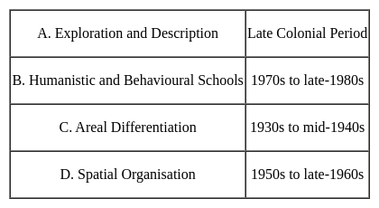
Identify the correct answer from the codes given below.
Detailed Solution for MH SET Paper 2 Mock Test - 9 (Geography) - Question 15
  • The temperature-depth profile shows a boundary region between the surface waters of the ocean and the deeper layers. This boundary region, from where there is a rapid decrease of temperature, is called the thermocline.
  • About 90 per cent of the total volume of water is found below the thermocline in the deep ocean. Hence Statement 1 is correct.
  • The thermocline layer is 500 to 1000m thick and is characterised by rapid decrease in temperature with increasing depth. Hence Statement 2 is correct.
  • The rate of decrease of temperature with increasing latitude is generally 0.5°C per latitude.
  • The oceans in the northern hemisphere record relatively higher temperatures than in the southern hemisphere. The highest temperature is not recorded at the equator but slightly towards north of it. Hence Statement 3 is incorrect.
MH SET Paper 2 Mock Test - 9 (Geography) - Question 16
Which of the following is not a component of human-made environment?
Detailed Solution for MH SET Paper 2 Mock Test - 9 (Geography) - Question 16

The environment is the air, water, and land in or on which people, animals, and plants live. Environment is our basic life support system. It provides the air we breathe, the water we drink, the food we eat and the land where we live. 

  • It is a combination of natural and human-made phenomena. While the natural environment refers to both biotic and abiotic conditions existing on the earth.
  • Land, water, air, plants and animals comprise the natural environment.
  • The term built environment, or built world, refers to the human-made surroundings that provide the setting for human activity, ranging in scale from buildings to parks.
  • It has been defined as "the human-made space in which people live, work, and recreate on a day-to-day basis." Settlement, agriculture, and transport are human-made environments but the land is not.

Hence, it is clear that land is not a component of a human-made environment.

MH SET Paper 2 Mock Test - 9 (Geography) - Question 17

Which of the following is not correctly matched:

Approaches - Periods

Detailed Solution for MH SET Paper 2 Mock Test - 9 (Geography) - Question 17

With this, new approaches can cross like welfare or humanistic school of thought, radical school of thought and behavioural school of thought.

MH SET Paper 2 Mock Test - 9 (Geography) - Question 18

When was National environment planning and coordination (NEPC) established?

Detailed Solution for MH SET Paper 2 Mock Test - 9 (Geography) - Question 18

In February 1972, National environment planning and coordination (NEPC) was established. This was the body that looked after all the environmental issues, plans, and polities. It was established in the Department of Science and technology.

MH SET Paper 2 Mock Test - 9 (Geography) - Question 19
Terra-Incognita concept given by-
Detailed Solution for MH SET Paper 2 Mock Test - 9 (Geography) - Question 19

The correct answer is Ptolemy. Key PointsTerra-Incognita:Terra incognita or terra ignota (Latin "unknown land"; incognita is stressed on its second syllable in Latin, but with variation in pronunciation in English) is a term used in cartography for regions that have not been mapped or documented. The expression is believed to be first seen in Ptolemy's Geography c. 150.

  • The term was reintroduced in the 15th century from the rediscovery of Ptolemy's work during the Age of Discovery.
  • The equivalent on French maps would be terres inconnues (plural form), and some English maps may show Parts Unknown.


Additional Information

Contributions of Ptolemy:

  • Planetary hypothesis
  • Text on classical astronomy entitled ‘Almagest’ ( the mathematical treatise)
  • The Geography/ The Guide to Geography
  • The optics and The Tetrabiblos
  • Astrology
  • Explore the Terra-Incognita (the unknown land)
  • A detailed topographical description of places and their history called ‘chorography’
  • He said 'geography is the science which deals with the art of map-making.'
MH SET Paper 2 Mock Test - 9 (Geography) - Question 20
Which one of the following is NOT an approach in physical geography?
Detailed Solution for MH SET Paper 2 Mock Test - 9 (Geography) - Question 20

While learning about physical geography, the most widely used way of obtaining data and information is by visiting, observation, exploration and description of the physical phenomenon. Further studies depend upon this approach rather than behaviouralism. Behaviouralism plays some part in human geography and in determining human behavior of humans.

Thus, the correct answer is B.

MH SET Paper 2 Mock Test - 9 (Geography) - Question 21
Consider the following statements:-

a. Geostationary satellites, at altitudes of approximately 29,000 km, revolve at speeds which match the rotation of the earth, so they seem stationary.

b. Weather and Communication satellites are commonly found in geosynchronous orbits.

c. Sun-synchronous satellites cover each area of the world at a constant local time of the day with almost no change in azimuth.

d. Geostationary satellites provide conditions for acquiring images in a specific season over successive years.

Which of the above statements are correct?

Detailed Solution for MH SET Paper 2 Mock Test - 9 (Geography) - Question 21

Geostationary satellites are placed at altitudes of about 36,000km, and revolve at speeds which match the rotation of the earth. Hence, always view the same portion of the earth’s surface E.g., METEOSAT, GOES-e. etc.,

Due to the position of the sun-synchronous satellites and consistent illumination conditions as they cover each area of the world at a constant local time of the day, images can be acquired in a specific season over successive years. This is an important factor for monitoring the changes between images as they do not have to be corrected for different illumination conditions.

MH SET Paper 2 Mock Test - 9 (Geography) - Question 22
According to Gunnar Myrdal's theory of circular cumulative causation, what is the main driver of economic growth?
Detailed Solution for MH SET Paper 2 Mock Test - 9 (Geography) - Question 22

Answer: Option 4) Self-reinforcing processes leading to cumulative growth.

Gunnar Myrdal, a Swedish economist and social scientist, developed the theory of circular cumulative causation to explain the persistence of poverty and inequality in developing countries. This theory emphasizes the self-reinforcing nature of economic growth and decline.
Key Points
  • According to Myrdal, the main driver of economic growth is:
  • Self-reinforcing processes leading to cumulative growth: Myrdal argued that economic growth is not a smooth and evenly distributed process, but rather a cumulative one, where certain factors and processes reinforce each other, leading to increasing disparities and imbalances. He identified several mechanisms through which this cumulative process operates:
  • Spread effects: Positive developments in one sector or region can spread to other sectors and regions, leading to a virtuous cycle of growth.
  • Backwash effects: Negative developments in one sector or region can have negative impacts on other sectors and regions, leading to a vicious cycle of decline.
  • Linkages: Economic activities in different sectors and regions are interconnected, and growth in one sector can lead to increased demand for goods and services from other sectors, creating a multiplier effect.
Important Points
  • Myrdal's theory has been influential in development economics, and has been applied to various contexts, including regional development, industrialization, and poverty reduction.
  • Critics of Myrdal's theory argue that it is too deterministic and does not adequately account for the role of government intervention and policy in shaping economic outcomes.
  • Despite these criticisms, Myrdal's theory remains a valuable framework for understanding the complex dynamics of economic growth and decline.
MH SET Paper 2 Mock Test - 9 (Geography) - Question 23

People move from rural to urban areas mainly for which of the following reasons?

(A) In search of employment

(B) In search of education

(C) In search of better health facilities

(D) In search of better accommodation

Detailed Solution for MH SET Paper 2 Mock Test - 9 (Geography) - Question 23

The correct answer is (A), (B), and (C) are correct.

Key Points

  • The correct answer is option 4, i.e., (A), (B), and (C) are correct.
  • Explanation:
    • People move from rural to urban areas primarily for better employment opportunities, better education facilities, and better health facilities.
    • -Rural areas often lack sufficient job opportunities and educational facilities, which leads people to migrate to urban areas.
    • Urban areas have better healthcare facilities, such as hospitals, clinics, and specialized doctors, which attract people seeking medical treatment.
    • Although better accommodation may also be a factor in people's decision to move to urban areas, it is not as significant as the other three factors mentioned above.

Additional Information

  • While education and employment are the primary reasons for migration to urban areas, people may also move for other reasons such as better lifestyle, social opportunities, and access to basic amenities.
  • Rural areas may also have their own unique advantages, such as lower cost of living, a closer-knit community, and a simpler lifestyle.
MH SET Paper 2 Mock Test - 9 (Geography) - Question 24

With reference to Titanium, consider the following statements:

1. Titanium is present in the Earth’s crust at a level of about 0.6% and is, therefore, the fourth most abundant structural metal after aluminum, iron and magnesium.

2. It is present in most igneous rocks and in sediments derived from them.

3. As of 2021, Russia had the largest reserves of titanium minerals worldwide.

How many of the statements given above are correct?

Detailed Solution for MH SET Paper 2 Mock Test - 9 (Geography) - Question 24

The correct answer is Only two​.

Key Points

Titanium

  • It is present in the Earth’s crust at a level of about 0.6% and is, therefore, the fourth most abundant structural metal after aluminium, iron and magnesium. Hence, Statement 1 is correct.
  • Titanium is always bonded to other elements in nature.
  • It is present in most igneous rocks and in sediments. Hence, Statement 2 is correct.
  • Its proportion in soils is approximately 0.5 to 1.5%.
  • It is widely distributed and occurs primarily in the minerals anatase, brookite, ilmenite, perovskite, rutile and titanite (sphene). The most important mineral sources are ilmenite (FeTiO3) and rutile (TiO2).
  • Significant titanium-bearing ilmenite deposits exist in Western Australia, Canada, China, India, Mozambique, New Zealand, Norway, Ukraine and South Africa, while rutile deposits are found in South Africa, India and Sierra Leone.
  • Titanium is obtained from various ores that occur naturally on the Earth. Ilmenite (FeTiO3) and rutile (TiO2) are the most important sources of titanium.
  • According to USGS, Ilmenite accounts for about 92% of the world’s consumption of titanium minerals.
  • World resources of anatase, ilmenite and rutile total more than 2 billion tonnes. Identified reserves total 750 million tonnes (ilmenite plus rutile).
  • As of 2021, China had the largest reserves of titanium minerals worldwide. China's entire reserves of titanium are found as ilmenite and amounted to approximately 230 million metric tons of titanium dioxide content that year. Hence, Statement 3 is not correct.
MH SET Paper 2 Mock Test - 9 (Geography) - Question 25
Given below are two statements. One is labelled as Assertion (A) and the other is labelled as Reason (R).

Assertion (A): The Puranas name the region of Madagascar and Eastern Africa as Shalmali.

Reason (R) : The region of East-Africa is rich in silk-cotton trees.

Select the correct answer from options given below:

Detailed Solution for MH SET Paper 2 Mock Test - 9 (Geography) - Question 25

As per the Puranas, the East African and Madagascar region was called as Shalmali. The silk-cotton was called salmala and it was found in the said region. The area had moderate rainfall and was located on margin of equatorial region, which led to blossom of silk-cotton trees. Thus, both (A) and (R) are true and (R) is the correct explanation of (A).

Thus, the correct answer is A.

MH SET Paper 2 Mock Test - 9 (Geography) - Question 26
In which decade feminist geography emerge in human geography?
Detailed Solution for MH SET Paper 2 Mock Test - 9 (Geography) - Question 26

Feminist geography emerged to inculcate women geographers and scholars in the field of geography. It focused on bringing out equality in the domain and giving equal opportunities to everyone irrespective of gender, class, creed, sexuality etc. Feminist geography emerged in 1980s as a new move.

MH SET Paper 2 Mock Test - 9 (Geography) - Question 27

Which among the following states leads in Handloom and Handicrafts clusters in India?

Detailed Solution for MH SET Paper 2 Mock Test - 9 (Geography) - Question 27

Uttar Pradesh leads in Handloom and Handicrafts clusters in India. There are at least six varieties of Uttar Pradesh handlooms, each deriving its name from the village in which it originated, and each with its own distinctive style.

MH SET Paper 2 Mock Test - 9 (Geography) - Question 28

Consider the Urban Settlements:

1. Conurbation

2. Megalopolis

3. Million City

4. Town

Which of the following is the correct sequence of the Urban settlements according to their increasing size?

Detailed Solution for MH SET Paper 2 Mock Test - 9 (Geography) - Question 28

The correct answer is option 4.

  • Increasing size: Town - Million City - Conurbation - Megalopolis.

Key PointsTypes of Urban Settlements:

  • Depending on the size and the services available and functions rendered, urban centers are designated as town, million cities, conurbations, and megalopolis.

Town:

  • The concept of ‘town’ can best be understood with reference to ‘village’.
  • Population size is not the only criterion.
  • Functional contrasts between towns and villages may not always be clear-cut, but specific functions such as manufacturing, retail and wholesale trade, and professional services exist in towns.

City:

  • A city may be regarded as a leading town, which has outstripped its local or regional rivals.
  • In the words of Lewis Mumford, “ the city is in fact the physical form of the highest and most complex type of associative life”.
  • Cities are much larger than towns and have a greater number of economic functions.
  • They tend to have transport terminals, major financial institutions and regional administrative offices.
  • When the population crosses the one million mark it is designated as a million city.

​Million City:

  • The number of million cities in the world has been increasing as never before.
  • London reached the million mark in 1800, followed by Paris in 1850, and New York in 1860, and by 1950 there were around 80 such cities.
  • The rate of increase in the number of million cities has been three-fold in every three decades – around 160 in 1975 to around 438 in 2005.

Conurbation:

  • The term conurbation was coined by Patrick Geddes in 1915.
  • It is applied to a large area of urban development that resulted from the merging of originally separate towns or cities.
  • Greater London, Manchester, Chicago and Tokyo are examples.

Megapolis:

  • This Greek word meaning “great city”, was popularised by Jean Gottman (1957) and signifies ‘super- metropolitan’ region extending, as the union of conurbations.
  • The urban landscape stretching from Boston in the north to south of Washington in the U.S.A. is the best-known example of a megalopolis.
MH SET Paper 2 Mock Test - 9 (Geography) - Question 29
National Clean Air Programme (NCAP) was launched in
Detailed Solution for MH SET Paper 2 Mock Test - 9 (Geography) - Question 29

 National Clean Air Programme (NCAP) was launched on 10th January 2019 by the Ministry of Environment, Forest and Climate Change. The tentative national level target of 20%–30% reduction of PM2.5 and PM10 concentration by 2024 is proposed under the NCAP taking 2017 as the base year for the comparison of concentration.

MH SET Paper 2 Mock Test - 9 (Geography) - Question 30

The use of microorganism metabolism to remove pollutants such as oil spills in the water bodies is known as :

Detailed Solution for MH SET Paper 2 Mock Test - 9 (Geography) - Question 30

Bioremediation is a process used to treat contaminated media, including water, soil and subsurface material, by altering environmental conditions to stimulate growth of microorganisms and degrade the target pollutants.

View more questions
60 tests
Information about MH SET Paper 2 Mock Test - 9 (Geography) Page
In this test you can find the Exam questions for MH SET Paper 2 Mock Test - 9 (Geography) solved & explained in the simplest way possible. Besides giving Questions and answers for MH SET Paper 2 Mock Test - 9 (Geography), EduRev gives you an ample number of Online tests for practice
Download as PDF