UPSC Exam  >  UPSC Tests  >  Test: Geography- 10 - UPSC MCQ

Test: Geography- 10 - UPSC MCQ


Test Description

25 Questions MCQ Test - Test: Geography- 10

Test: Geography- 10 for UPSC 2024 is part of UPSC preparation. The Test: Geography- 10 questions and answers have been prepared according to the UPSC exam syllabus.The Test: Geography- 10 MCQs are made for UPSC 2024 Exam. Find important definitions, questions, notes, meanings, examples, exercises, MCQs and online tests for Test: Geography- 10 below.
Solutions of Test: Geography- 10 questions in English are available as part of our course for UPSC & Test: Geography- 10 solutions in Hindi for UPSC course. Download more important topics, notes, lectures and mock test series for UPSC Exam by signing up for free. Attempt Test: Geography- 10 | 25 questions in 30 minutes | Mock test for UPSC preparation | Free important questions MCQ to study for UPSC Exam | Download free PDF with solutions
Test: Geography- 10 - Question 1

Consider the following statements regarding Ocean Currents.

  1. Water density and temperature influences the mobility of ocean currents.
  2. Cold Water ocean currents travel from the equator along the surface, towards the cold polar regions.
  3. Labrador current is a cold current.

Which of the above statements is/are correct?

Detailed Solution for Test: Geography- 10 - Question 1

Differences in water density affect vertical mobility of ocean currents. Water with high salinity is denser than water with low salinity and in the same way cold water is denser than warm water. Denser water tends to sink, while relatively lighter water tends to rise. Cold-water ocean currents occur when the cold water at the poles sinks and slowly moves towards the equator. Warm-water currents travel out from the equator along the surface, flowing towards the poles to replace the sinking cold water.

Test: Geography- 10 - Question 2

Consider the following statements.

  1. Surface current constitute more than the deep-water currents.
  2. Cold currents are usually found in the west coast in the higher latitudes in the Northern Hemisphere.
  3. Warm currents are found on the east coast of continents in the low and middle latitudes.

Which of the above statements is/are correct?

Detailed Solution for Test: Geography- 10 - Question 2

Ocean currents can also be classified based on temperature: as cold currents and warm currents:
(i) cold currents bring cold water into warm water areas. These currents are usually found on the west coast of the continents in the low and middle latitudes (true in both hemispheres) and on the east coast in the higher latitudes in the Northern Hemisphere;
(ii) warm currents bring warm water into cold water areas and are usually observed on the east coast of continents in the low and middle latitudes (true in both hemispheres). In the northern hemisphere they are found on the west coasts of continents in high latitudes.

1 Crore+ students have signed up on EduRev. Have you? Download the App
Test: Geography- 10 - Question 3

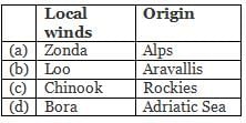
Which of the following are not correctly matched?

Detailed Solution for Test: Geography- 10 - Question 3

Zonda is a local wind blows in Andes Mountain range.

Test: Geography- 10 - Question 4

Consider the following statements:

  1. Garo and Khasi hills are extensions of Purvanchals in Meghalaya forming water divide between Brahmaputra and Barak River.
  2. Rajmahal Hills are formed from rocks dating from the Jurassic Period and named after the town of Rajmahal which lies to the east in the state of Jharkhand.

Which of the above statements is/are correct?

Detailed Solution for Test: Geography- 10 - Question 4

Garo and Khasi hills are the extensions of peninsular part of the subcontinent. Along with the Karbi Anglong plateau, the Meghalaya plateau (comprising Garo, Khasi and Jaintia hills) is separated from the Chotanagpur plateau (part of peninsular india ) by Malda fault (in Bengal).
Volcanic activity during the Jurassic resulted in the formation of the Rajmahal Traps. The Rajmahal hills are named after the town of Rajmahal which lies in the eastern Jharkhand. The River Ganges wanders around the hills changing the direction of flow from east to south.

Test: Geography- 10 - Question 5

Tropic of Capricorn passes through which of the following countries?

  1. Argentina
  2. Bolivia
  3. Chile
  4. Botswana
  5. Mozambique
  6. Zimbabwe
  7. Australia

Select the correct answer code:

Detailed Solution for Test: Geography- 10 - Question 5

Tropic of Capricorn passes through:

  • South America: Argentina, Brazil, Chile, Paraguay
  • Africa: Namibia, Botswana, South Africa, Mozambique, Madagascar
  • Australia
  • Water Bodies: Indian Ocean, Atlantic Ocean, Pacific Ocean.
Test: Geography- 10 - Question 6

Which of the following are the examples of footloose industries?

  1. Mobile manufacturing
  2. Diamond processing
  3. Iron and Steel Industry
  4. Computer chips industries
  5. Cement industry

Select the correct answer code:

Detailed Solution for Test: Geography- 10 - Question 6
  • Footloose industry is a general term for an industry that can be placed and located at any location without effect from factors of production such as resources, land, labour, and capital.
  • These industries often have spatially fixed costs, which means that the costs of the products do not change despite where the product is assembled. Diamonds, computer chips, and mobile manufacturing are some examples of footloose industries
  • Non-footloose industries generally require raw material availability within a time limit to make products. Sugar industry, jute industry and tea industry are the examples of non-footloose industries.
  • Location of Cotton textiles, Cement industry and, Iron and Steel industries largely depend upon location of the raw materials. Thus, cannot be considered under the category of the Footloose industries.
Test: Geography- 10 - Question 7

Which of the following activities belong to the Quaternary activities in an Economy?

  1. Production and dissemination of information
  2. Research and development
  3. Medical Tourism

Select the correct answer code:

Detailed Solution for Test: Geography- 10 - Question 7

Quaternary activities involve some of the following: the collection, production and dissemination of information or even the production of information. Quaternary activities centre around research, development and may be seen as an advanced form of services involving specialised knowledge and technical skills.
Medical tourism is classified into tertiary sector of the economy.

Test: Geography- 10 - Question 8

Which of the following are ferrous minerals?

  1. Bauxite
  2. Iron Ore
  3. Copper
  4. Manganese

Select the correct answer code:

Detailed Solution for Test: Geography- 10 - Question 8

Ferrous minerals are the metallic minerals containing iron. While non-ferrous minerals are also metallic, but they do not contain iron.
Examples of Ferrous minerals: Iron ore, Manganese, Nickel, Cobalt etc.
Examples of Non-ferrous minerals: Gold, silver, copper, lead, bauxite, tin, magnesium etc.

Test: Geography- 10 - Question 9

According to Mines and Minerals (Development and Regulation) Act, 1957, which of the following are declared as Minor Minerals?

  1. Chalk
  2. Lignite
  3. Brick-earth
  4. Marble
  5. Gravel

Select the correct answer code:

Detailed Solution for Test: Geography- 10 - Question 9

According to section 3(e) of the Mines and Minerals (Development and Regulation) Act, 1957 “Minor Minerals” means building stones, gravel, ordinary clay, ordinary sand other than sand used for prescribed purposes, and any other mineral which the Central Government may, by notification in the Official Gazette, declare to be a minor mineral.
Major minerals are those specified in the first schedule appended in the Mines and Minerals (Development and Regulation) Act, 1957 (MMDR Act 1957) and the common major minerals are Lignite, Coal, Uranium, iron ore, gold etc. It may be noted that there is no official definition for “major minerals” in the MMDR Act. Hence, whatever is not declared as a “minor mineral” may be treated as the major mineral.

Test: Geography- 10 - Question 10

Which among the following best describes the term ‘Black Gold’? 

Detailed Solution for Test: Geography- 10 - Question 10

Petroleum and its derivatives are called Black Gold as they are very valuable.

Test: Geography- 10 - Question 11

Consider the following statements.

  1. S-waves produced by an earthquake can travel only through solid materials.
  2. ‘Shadow zone’ of an earthquake refers to the zone where the tendency of experiencing an earthquake is the maximum.

Which of the above statements is/are correct?

Detailed Solution for Test: Geography- 10 - Question 11
  • Earthquake waves get recorded in seismographs located at far off locations. However, there exist some specific areas where the waves are not reported. Such a zone is called the ‘shadow zone’.
  • An important fact about S-waves is that they can travel only through solid materials. This characteristic of the S-waves is quite important as it has helped scientists to understand the structure of the interior of the earth.
Test: Geography- 10 - Question 12

Earthquakes can occur at

  1. Divergent plate boundaries.
  2. Transform boundaries.
  3. Ocean-ocean convergent plate boundaries
  4. Ocean-continent plate boundaries.

Select the correct answer code:

Detailed Solution for Test: Geography- 10 - Question 12

Most earthquakes occur at the boundaries where the plates meet. In fact, the locations of earthquakes and the kinds of ruptures they produce help scientists define the plate boundaries.
There are three types of plate boundaries: spreading zones, transform faults, and subduction zones.

  • At spreading zones, molten rock rises, pushing two plates apart and adding new material at their edges. Most spreading zones are found in oceans; for example, the North American and Eurasian plates are spreading apart along the mid-Atlantic ridge. Spreading zones usually have earthquakes at shallow depths.
  • Transform faults are found where plates slide past one another. Earthquakes at transform faults tend to occur at shallow depths and form fairly straight linear patterns.
  • Subduction zones are found where one plate overrides, or subducts, another, pushing it downward into the mantle where it melts. Subduction zones are characterized by deep-ocean trenches, shallow to deep earthquakes, and mountain ranges containing active volcanoes.

A divergent boundary occurs when two tectonic plates move away from each other. Along these boundaries, earthquakes are common and magma (molten rock) rises from the Earth’s mantle to the surface, solidifying to create new oceanic crust.
At an ocean-ocean convergent boundary, one of the plates (oceanic crust and lithospheric mantle) is pushed, or subducted, under the other. Earthquakes occur relatively deep below the seafloor, where the subducting crust moves against the overriding crust.
At an ocean-continent convergent boundary, the denser oceanic plate is pushed under the less dense continental plate in the same manner as at an ocean-ocean boundary.

Test: Geography- 10 - Question 13

Arrange the following regions in decreasing order based on the potential of Incidences of Landslides:

  1. Himalayas
  2. North-eastern Hills
  3. Vindhyachal
  4. Western Ghats and the Nilgiris

Select the correct answer code:

Detailed Solution for Test: Geography- 10 - Question 13

The two regions most vulnerable to landslides are the Himalayas and the Western Ghats. The Himalayas mountain belt comprise of tectonically unstable younger geological formations subjected to severe seismic activity. The Western Ghats and nilgiris are geologically stable but have uplifted plateau margins influenced by neo- tectonic activity. Compared to Western Ghats region, the slides in the Himalayas region are huge and massive.

Test: Geography- 10 - Question 14

Brahmaputra River is often flooded in India, but not in Tibet. What can be the possible causes for it?

  1. In India it passes through a region of high rainfall, while Tibet is a dry cold area.
  2. Brahmaputra is marked by huge deposits of silt on its bed causing the river bed to rise.

Select the correct answer code:

Detailed Solution for Test: Geography- 10 - Question 14

In Tibet the river carries a smaller volume of water and less silt as it is a cold and a dry area. In India it passes through a region of high rainfall. Here the river carries a large volume of water and considerable amount of silt.
Every year during the rainy season, the river overflows its banks, causing widespread devastation due to floods in Assam and Bangladesh. Unlike other north Indian rivers the Brahmaputra is marked by huge deposits of silt on its bed causing the river bed to rise. The river also shifts its channel frequently.

Test: Geography- 10 - Question 15

Among the following, the crop that is least drought-resistant is 

Detailed Solution for Test: Geography- 10 - Question 15
  • The least drought resistant crop would be the one requiring most rainfall for growth.
  • Sugarcane is cultivated in the tropics and subtropics in areas with a plentiful supply of water for a continuous period of more than six to seven months each year, either from natural rainfall or through irrigation.
  • Millets have a low water requirement both in terms of the growing period and overall water requirement during growth.
  • Groundnuts requires nearly 50-75 cm rainfall.
  • Maize requires 50 to 100 cm rainfall and cannot be grown in areas of more than 100 cm rainfall.
Test: Geography- 10 - Question 16

Practices that increase organic matter in the soil include

  1. Leaving crop residues in the field
  2. Frequent tillage
  3. Mulching
  4. Growing cover crops

Select the correct answer code:

Detailed Solution for Test: Geography- 10 - Question 16

Practices that increase organic matter include: leaving crop residues in the field, choosing crop rotations that include high residue plants, using optimal nutrient and water management practices to grow healthy plants with large amounts of roots and residue, growing cover crops, applying manure or compost, using low or no tillage systems, using sod-based rotations, growing perennial forage crops, and mulching.

Test: Geography- 10 - Question 17

Consider the following statements:

  1. The folds of the Great Himalayas are symmetrical in nature.
  2. The longitudinal valley lying between lesser Himalaya and the Shiwaliks are known as Duns.

Which of the above statements is/are incorrect?

Detailed Solution for Test: Geography- 10 - Question 17

The folds of the Great Himalayas are asymmetrical in nature.
The longitudinal valley lying between lesser Himalaya and the Shiwaliks are known as Duns. Ex Chandigarh-Kalka dun, Nalagarh dun, Dehra Dun, Harike dun and the Kota dun, etc. Dehra Dun is the largest of all the duns with an approximate length of 35-45 km and a width of 22-25 km.

Test: Geography- 10 - Question 18

Consider the following statements regarding Red and yellow soils.

  1. They can develop on crystalline igneous rocks.
  2. They are found only in regions of highest rainfall and highest temperature in India.
  3. They look yellow when it occurs in a hydrated form.

Which of the above statements is/are correct?

Detailed Solution for Test: Geography- 10 - Question 18

Most of the soils in Boreal forests are strongly leached as a result of centuries of leaching and somewhat impoverished parent materials. The soils are generally strongly acid and the main soil process under this dominantly leaching climate is ‘podzolisation’ leading to podzolic soils. The extreme climate coupled with the strong soil acidity means that relatively few organisms exist in the soil and the turnover of organic matter is slow.

Test: Geography- 10 - Question 19

Consider the following statements regarding Alluvial soils.

  1. Alluvial soils are suitable for the growth of sugarcane, paddy and pulse crops.
  2. Alluvial soils contain adequate proportion of potash, phosphoric acid and lime.

Which of the above statements is/are incorrect?

Detailed Solution for Test: Geography- 10 - Question 19

Alluvial soils as a whole are very fertile. Mostly these soils contain adequate proportion of potash, phosphoric acid and lime which are ideal for the growth of sugarcane, paddy, wheat and other cereal and pulse crops. Due to its high fertility, regions of alluvial soils are intensively cultivated and densely populated.

Test: Geography- 10 - Question 20

Mangrove forests can be found in which of the following river deltas?

  1. Cauvery
  2. Krishna
  3. Mahanadi
  4. Godavari

Select the correct answer code:

Detailed Solution for Test: Geography- 10 - Question 20

Mangrove forests grow by the side of the coast and on the edges of the deltas. The fertile deltas of the Cauvery, Krishna, Mahanadi, Godavari, and Ganga comprises of mangrove forest. In the state of West Bengal, these forests are known as ‘Sundarbans’.
The mangrove forest is also referred to as Tidal forest because this forest can live both in salt and freshwater. It can survive in tidal regions as well.

Test: Geography- 10 - Question 21

Which of the following factors Influence the formation of South-West Monsoon?

  1. Shift of the position of Inter Tropical Convergence Zone (ITCZ)in summer.
  2. Presence of the high-pressure area,east of Madagascar, approximately at 20°S over the Indian Ocean.
  3. Movement of the westerly jet stream to the north of the Himalayas and the presence of the tropical easterly jet stream over the Indian peninsula during summer.

Select the correct answer code:

Detailed Solution for Test: Geography- 10 - Question 21

Factors Influencing South-West Monsoon Formation

  • The differential heating and cooling of land and water creates a low pressure on the landmass of India while the seas around experience comparatively high pressure.
  • The shift of the position of Inter Tropical Convergence Zone (ITCZ)in summer, over the Ganga plain (this is the equatorial trough normally positioned about 5°N of the equator. It is also known as the monsoon-trough during the monsoon season).
  • The presence of the high-pressure area, east of Madagascar, approximately at 20°S over the Indian Ocean. The intensity and position of this high-pressure area affect the Indian Monsoon.
  • The Tibetan plateau gets intensely heated during summer, which results in strong vertical air currents and the formation of low pressure over the plateau at about 9 km above sea level.
  • The movement of the westerly jet stream to the north of the Himalayas and the presence of the tropical easterly jet stream over the Indian peninsula during summer.
Test: Geography- 10 - Question 22

Winter rainfall in Punjab, Haryana, Delhi and western Uttar Pradesh occurs mainly due to

  1. Northeast monsoon crossing over the Bay of Bengal
  2. Anti-cyclonic circulation patterns in Northern India in winter
  3. Arrival of weak temperate cyclones from the Mediterranean Sea

Select the correct answer code:

Detailed Solution for Test: Geography- 10 - Question 22

Winter monsoons do not cause rainfall as they move from land to the sea. It is because firstly, they have little humidity; and secondly, due to anti cyclonic circulation on land, the possibility of rainfall from them reduces. So, most parts of India do not have rainfall in the winter season. However, there are some exceptions to it:

  • In northwestern India, some weak temperate cyclones from the Mediterranean sea cause rainfall in Punjab, Haryana, Delhi and western Uttar Pradesh.
  • During October and November, northeast monsoon while crossing over the Bay of Bengal, picks up moisture and causes torrential rainfall over the Tamil Nadu coast, southern Andhra Pradesh, southeast Karnataka and southeast Kerala.
Test: Geography- 10 - Question 23

Consider the following statements regarding ‘Savanna Climate’.

  1. It is characterised by an alternate hot, rainy season and cool, dry season.
  2. Majority of the areas have lateritic soils which support good crops.
  3. The Hausa tribes are found here.

Which of the above statements is/are correct?

Detailed Solution for Test: Geography- 10 - Question 23

Savannah climate:

  • This type of climate has alternate wet and dry seasons. There are Only two seasons – winter and summer. Rains occur in summer. Due to distinct wet and dry periods, many Savanna areas have poor lateritic soils which are incapable of supporting good crops.
  • Many tribes live in savanna region. Tribes like the Masai tribes of the East African plateau are pastoralists whereas Hausa of northern Nigeria are settled cultivators.
Test: Geography- 10 - Question 24

Which of these seasons provide the most favourable conditions for the redistribution of water and oxygen in lakes that are vital for the growth of organisms such as phytoplankton?

Detailed Solution for Test: Geography- 10 - Question 24

In summer and winter, water across layers of lake hardly mixes. So, either the upper layer or deep water is cold or warm. Hence, there is little churning of oxygen and nutrients due to this large temperature difference.
But, due to similar water temperatures at both surface and under water in autumn and spring, water tends to mix. This mixing facilitates better nutrient availability in all layers increasing productivity of lakes.

Test: Geography- 10 - Question 25

If the elliptical orbit of earth around the Sun changes to a circular orbit, which one among the following may result in that situation? 

Detailed Solution for Test: Geography- 10 - Question 25

Earth’s tilted axis causes the seasons. Throughout the year, different parts of Earth receive the Sun’s most direct rays. So, when the North Pole tilts toward the Sun, it’s summer in the Northern Hemisphere. And when the South Pole tilts toward the Sun, it’s winter in the Northern Hemisphere.

Information about Test: Geography- 10 Page
In this test you can find the Exam questions for Test: Geography- 10 solved & explained in the simplest way possible. Besides giving Questions and answers for Test: Geography- 10, EduRev gives you an ample number of Online tests for practice

Top Courses for UPSC

Download as PDF

Top Courses for UPSC