UPSC Exam  >  UPSC Tests  >  Additional Study Material for UPSC  >  Test: Geography- 2 - UPSC MCQ

Test: Geography- 2 - UPSC MCQ


Test Description

20 Questions MCQ Test Additional Study Material for UPSC - Test: Geography- 2

Test: Geography- 2 for UPSC 2024 is part of Additional Study Material for UPSC preparation. The Test: Geography- 2 questions and answers have been prepared according to the UPSC exam syllabus.The Test: Geography- 2 MCQs are made for UPSC 2024 Exam. Find important definitions, questions, notes, meanings, examples, exercises, MCQs and online tests for Test: Geography- 2 below.
Solutions of Test: Geography- 2 questions in English are available as part of our Additional Study Material for UPSC for UPSC & Test: Geography- 2 solutions in Hindi for Additional Study Material for UPSC course. Download more important topics, notes, lectures and mock test series for UPSC Exam by signing up for free. Attempt Test: Geography- 2 | 20 questions in 25 minutes | Mock test for UPSC preparation | Free important questions MCQ to study Additional Study Material for UPSC for UPSC Exam | Download free PDF with solutions
Test: Geography- 2 - Question 1

Most of the weather phenomena takes place in troposphere only because

Test: Geography- 2 - Question 2

The actual moisture content of a sample of air asa percentage of that contained in the same volumeof saturated air at the same temperature iscalled

Detailed Solution for Test: Geography- 2 - Question 2

The correct answer is B as The actual moisture content of a sample of air asa percentage of that contained in the same volume of saturated air at the same temperature is called relative humidity.

1 Crore+ students have signed up on EduRev. Have you? Download the App
Test: Geography- 2 - Question 3

Which one of the following regions receives therainfall throughout the year due to westerly winds?

Detailed Solution for Test: Geography- 2 - Question 3

The region that receives rainfall throughout the year due to westerly winds is South Chile (Option D). South Chile, particularly the southern part of the country, experiences a maritime climate influenced by the westerlies. These winds carry moisture from the Pacific Ocean, resulting in abundant rainfall throughout the year in areas like the coastal regions and the southern Andes Mountains. This consistent rainfall supports the growth of temperate rainforests and contributes to the region's unique biodiversity.


Test: Geography- 2 - Question 4

Which one of the following combinations is responsiblefor higher salinity in ocean water ?

Detailed Solution for Test: Geography- 2 - Question 4

B is the correct option.Low rainfall, low supply of fresh water and high evaporation are the main reason of high salinity. Salinity can affect the density of ocean water: Water that has higher salinity is denser and heavier and will sink underneath less saline, warmer water.

Test: Geography- 2 - Question 5

Which one of the following is NOT a factor modifyingocean currents ?

Detailed Solution for Test: Geography- 2 - Question 5

The correct option is B.
The factors that can modify the currents are direction and shape of coastlines, bottom reliefs of the ocean basins, seasonal variations and rotation of the earth. Ocean circulation is driven by winds and by differences in water density.

Test: Geography- 2 - Question 6

Consider the following statements :

The horizontal distribution of temperature of ocean water is largely affected by
1. depth of water in the ocean
2. ocean currents
3. prevailing winds
4. latitude

Which of these are correct?

Test: Geography- 2 - Question 7

Consider the following statements :

1. Hydrogenous deposits are formed very slowly
2. Phosphates are found either in the form of nodules or in the form of thin crust
3. Glauconite is a biogenous sediment

Which of these are correct?

Detailed Solution for Test: Geography- 2 - Question 7

Hydrogenous sediments are sediments solidified out of ocean water. As such, chemical reactions create these kinds of sediments. The precipitation of dissolved chemicals from seawater. These kinds of sediments are found commonly near hydrothermal vents.
Phosphate nodules: These are spherical concentrations that are randomly distributed along the floor of continental shelves. Most phosphorite grains are sand size although particles greater than 2 mm may be present. These larger grains, referred to as nodules, can range up to several tens of centimeters in size.
 

Test: Geography- 2 - Question 8

Consider the following relief features :

1. Zanskar Range
2. Dhauladhar Range
3. Laddakh Range
4. Karakorma Range

The correct northward sequence of these relief features is

Detailed Solution for Test: Geography- 2 - Question 8

The correct sequence of these mountain ranges from south to north are
Dhauladhar Range, Zanskar Range, Ladakh Range and Karakoram.

Test: Geography- 2 - Question 9

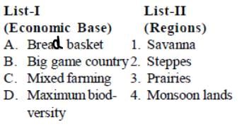
Match List-I with List-II and select the correct answer.

Test: Geography- 2 - Question 10

Match List-I with List-II and select the correct answer.

Test: Geography- 2 - Question 11

Match List-I with List-II and select the correct answer.

Test: Geography- 2 - Question 12

Consider the following statements :

Tropical crops, which are in great demand in Anglo- America and Europe, are produced in great variety and volume in Latin America and Africa because of

1. availability of a cultivable land and suitability of soil conditions
2. combination of climatic and topographical conditions
3. lack of mineral resources for trading purpose
4. non-existence of agro-based industries

Which of these are correct?

Detailed Solution for Test: Geography- 2 - Question 12

The category “tropical crops” refers to plants that grow in tropical climates. ropical climates are generally warm to hot year-round. Depending on the location many tropical areas have a dry and wet season.

Test: Geography- 2 - Question 13

Match List-I with List-II and select the correct answer.

Test: Geography- 2 - Question 14

Consider the following countries of South Africa :

1. Botswana
2. Lesotho
3. Zambia
4. Zimbabwe

The correct sequence of these countries, in termsof their proximity to the equator, is

Test: Geography- 2 - Question 15

Earthquakes along the Himalayas and the foothills are best explained in terms of

Detailed Solution for Test: Geography- 2 - Question 15

The Himalaya are among the most seismically active regions in the world, the result of an ongoing collision between two continental plates tectonics: the Indian and the Eurasian.Each jerky advance causes earthquakes of varying intensity

Test: Geography- 2 - Question 16

Which of the following is the first biosphere reservein India?

Test: Geography- 2 - Question 17

Consider the following statements:

I. The habitat of Date Palms is warm deserts with little or no rainfall.

II. Date Palm is a tree of waterless desert.

Detailed Solution for Test: Geography- 2 - Question 17

Correct Answer :- c

Explanation : a) The Date palm (Phoenix dactylifera L.) is grown throughout the arid and semiarid regions of the world, particularly in West Asia and North Africa. It is well adapted to the desert environment, where a dry and warm climate is important for fruit maturity and ripening.

Date palm trees are the tress which require only little amount of water. deserts are the areas where the temperature is high and rainfall is low.

b) The huge leaves are made to survive a hot, dry climate, and adapt the tree to long summers without rain, but the palm needs a source of regular water. The date palm's ideal growing conditions are found in the more watery areas of the subtropical deserts of the Middle East: oases and river banks.

Test: Geography- 2 - Question 18

Consider the following statements:

A. Increase in agricultural production in China has been due to higher per hectare yields.

R. China accomplished socialist transformation in all branches of the economy, including agriculture.

Test: Geography- 2 - Question 19

Consider the following statements:

I. Peninsular India is a region free from tectonicdisturbances.

II. The configuration and drainage of peninsularIndia are influenced by fracturing and tiltingof the massif.

Detailed Solution for Test: Geography- 2 - Question 19

The Peninsular drainage system is older than the Himalayan one. This is evident from the broad, largely-graded shallow valleys, and the maturity of the rivers.

Evolution: Three major geological events in the distant past have shaped the present drainage systems of Peninsular India:

  • Subsidence of the western flank of the Peninsula leading to its submergence below the sea during the early tertiary period. Generally, it has disturbed the symmetrical plan of the river on either side of the original watershed and left just the upper parts of west flowing rivers above the sea level.

  • Upheaval of the Himalayas when the northern flank of the Peninsular block was subjected to subsidence and the consequent trough faulting. The Narmada and The Tapi flow in trough faults and fill the original cracks with their detritus materials. Hence, there is a lack of alluvial and deltaic deposits in these rivers.

  • Slight tilting of the Peninsular block from north-west to the southeastern direction gave orientation to the entire drainage system towards the Bay of Bengal during the same period.

Test: Geography- 2 - Question 20

Consider the following statements:

I. In winters, the northern half of India is warmerthan areas at similar latitudes outside the countryby 3°C to 8°C.

II. the presence of the Himalayas with their eastand west extent is the cause.

20 videos|561 docs|160 tests
Information about Test: Geography- 2 Page
In this test you can find the Exam questions for Test: Geography- 2 solved & explained in the simplest way possible. Besides giving Questions and answers for Test: Geography- 2, EduRev gives you an ample number of Online tests for practice

Top Courses for UPSC

20 videos|561 docs|160 tests
Download as PDF

Top Courses for UPSC