UPSC Exam  >  UPSC Tests  >  Test: Geography - 4 - UPSC MCQ

Test: Geography - 4 - UPSC MCQ


Test Description

30 Questions MCQ Test - Test: Geography - 4

Test: Geography - 4 for UPSC 2024 is part of UPSC preparation. The Test: Geography - 4 questions and answers have been prepared according to the UPSC exam syllabus.The Test: Geography - 4 MCQs are made for UPSC 2024 Exam. Find important definitions, questions, notes, meanings, examples, exercises, MCQs and online tests for Test: Geography - 4 below.
Solutions of Test: Geography - 4 questions in English are available as part of our course for UPSC & Test: Geography - 4 solutions in Hindi for UPSC course. Download more important topics, notes, lectures and mock test series for UPSC Exam by signing up for free. Attempt Test: Geography - 4 | 30 questions in 36 minutes | Mock test for UPSC preparation | Free important questions MCQ to study for UPSC Exam | Download free PDF with solutions
Test: Geography - 4 - Question 1

With reference to lakes in India, consider the following statements

1. Wular lake is the largest salt water lake in India.
2. Kolleru lake is a freshwater lake.
3. Gurudongmar lake is situated in Himachal pradesh.

Which of the above statements is/are correct?

Detailed Solution for Test: Geography - 4 - Question 1
  • Wular lake is a fresh water lake in jammu and kashmir.
  • Gurudongmar lake is situated in sikkim.
Test: Geography - 4 - Question 2

Which of the following statements is correct regarding the Ionosphere layer of the atmosphere?

Detailed Solution for Test: Geography - 4 - Question 2

Temperature in the ionosphere layer starts increasing with height.
Ionosphere:
• The ionosphere is located between 80 and 400 km above the Mesopause.
• It contains electrically charged particles known as ions, and hence, it is known as the ionosphere.
• Radio waves transmitted from the earth are reflected back to the earth by this layer.
• The temperature here starts increasing with height.
• The uppermost layer of the atmosphere above the ionosphere is known as the Exosphere.
All changes in climate and weather take place in the troposphere layer.

1 Crore+ students have signed up on EduRev. Have you? Download the App
Test: Geography - 4 - Question 3

Consider the following statements regarding LADIS – Least Available Depth Information System:
1. It is being implemented by Ministry of Jal Shakti.
2. It gives real-time data on the least available depths (LADs) to ships and cargoes.
3. Presently the information of LADs is being used by all the national waterways.
Which of the above statements is/are correct?

Detailed Solution for Test: Geography - 4 - Question 3

• Statement 1 is incorrect: The system is being implemented by the Ministry of Shipping.
• Statement 3 is incorrect: The information is being used by NW-1, NW-2, IndoBangladesh Protocol route, and NW-3. It will be extended for other NW later.
LADIS – Least Available Depth Information System
• The Inland Waterways Authority of India (IWAI) under Ministry of Shipping recently launched this new portal called ‘LADIS’ – Least Available Depth Information System.
• The portal will ensure that the realtime data on least available depths (LADs) is disseminated for ship and barge and cargo owners so that they can undertake transportation on the national waterways in a more planned way.
• The details of the LAD will be fed into the portal by respective surveyors and regional in-charge deputed with Inland Waterways Authority of India survey vessels, which constantly move on national waterways.
• The Inland Waterways Authority of India has designed the portal to facilitate the day to day operations of inland vessels plying on National Waterways and to avoid any hindrance in service and operation.
• Initially, the information of LADs will be available for national waterway 1, national waterway 2, Indo-Bangladesh Protocol route and national waterway 3, along with the date of the survey. The facility will soon be expanded to other national waterways as well.
• It will enhance the credibility and efficiency of information sharing to achieve seamless operations on National Waterways, besides pre-empting problems that may occur during the movement of vessels.
• The vessel operators and cargo owners will prepare their sailing plans strictly as per applicable waterways related information (Hydrographic survey reports, River Notices) available on IWAI’s website.

Test: Geography - 4 - Question 4

Which of the following is/are the salt water lakes of India?
1) Pangong tso lake
2) Tso moriri lake
3) Sambhar lake
4) Chilika lake
5) Pulicat lake

Detailed Solution for Test: Geography - 4 - Question 4

The correct option is Option B.

Though it is a saline water lake, it freezes completely during winters. The brackish water of Pangong Lake has very low micro-vegetation. Reportedly, there is no fish or any aquatic life in the lake, except crustaceans.

The Sambhar Salt Lake, India's largest inland salt lake, a bowl shaped lake encircles historical Sambhar Lake Town located 96 km south west of the city of Jaipur .

It is understandable that coastal lakes like Chilika and Kilivili are salty as they receive salty water from the oceans, but sambhar lake is an inland lake receiving most of its water from south-west monsoon.

The water is fed to the lake from the rivers Mendha, Runpangarh, Khandel and Karian.

 As it is endorheic (has no outlet besides evaporation), it has very high salinity, far saltier than seawater, and its mineral content is constantly increasing.

It is India's largest saline lake and is the source of most of Rajasthan's salt production.

Sambhar Salt Lake is India's largest salt lake and is located 96 km south west of the city of Jaipur (Northwest India) and 64 km north east of Ajmer along the National highway 8 in Rajasthan. 

Chilka Lake (also Chilika Lake) is a brackish water coastal lake in India's Orissa state, south of the mouth of the Mantei River. It is the largest coastal lake in India.

Lying at the boundary of the states of Andhra Pradesh and Tamil Nadu, Pulicat Lake is the second largest saltwater lake in India. The lake is separated by the Bay of Bengal by the barrier island of Sriharikota, which is also a rocket launching centre.

Test: Geography - 4 - Question 5

Consider the following statements regarding soil profile and horizons:
1. There is a gradual increase of organic matter with increasing depth.
2. The level of aeration of the soil decreases from the surface downwards in the soil profile.
Which of the above statements is/are correct?

Detailed Solution for Test: Geography - 4 - Question 5

• Statement 1 is incorrect: There is a gradual decrease of organic matter with increasing depth.
Soil Profile and Horizon
• A soil profile is a display of vertical section from the ground surface down to the parent rocks. Thus, a soil profile denotes the vertical distribution of soil components (e.g: the living organisms-flora and fauna and organic matter, the inorganic minerals, the soil solution and the attributes of soil atmosphere) and various associations of the properties of these components. The soil profile is characterized by the following common properties:
1. On average, there is gradual decrease of organic matter, number of living organisms, activity of living organisms, etc. with increasing depth in the soil profile.
2. The level of aeration of the soil decreases from the surface downwards in the soil profile.
3. There is an increase in the number and variety of parent minerals from the surface downward in the soil profile up to the base of parent rocks.
4. There is no definite trend of either increase or decrease in the content of soil water with depth because there is a lot of fluctuation in water content. The content of soil water is determined by:
• The location of groundwater
• Nature of the movement of groundwater
• Frequency and amount of rainfall
• Absorptive characteristics of different horizons of the soil profile.

Test: Geography - 4 - Question 6

Consider the following statements regarding phosphorous cycle:
1. A phosphorous cycle is an example of a sedimentary cycle.
2. Phosphorous is mainly found as phosphates in the earth’s crust.
3. Tectonic upliftment and denudation are the main processes responsible for the phosphorus cycle.
Which of the above statements is/are correct?

Detailed Solution for Test: Geography - 4 - Question 6

• All statements are correct
Phosphorus Cycle
• Phosphorus plays a central role in aquatic ecosystems and water quality. This is the nutrient considered to be the main cause of excessive growth of rooted and free-floating microscopic plants in lakes.
• Unlike carbon and nitrogen, which come primarily from the atmosphere, phosphorus occurs in large amounts as a mineral in phosphate rocks and enters the cycle from erosion and mining activities.
• The main storage for phosphorus is in the earth’s crust. Thus it is an example of a sedimentary cycle.
• Tectonic upliftment and denudational processes are the main processes responsible for the phosphorus cycle.
• On land, phosphorus is usually found in the form of phosphates. By the process of weathering and erosion, phosphates enter rivers and streams that transport them to the ocean.
• In the ocean, once the phosphorus accumulates on continental shelves in the form of insoluble deposits. After millions of years, the crustal plates rise from the seafloor and expose the phosphates on land. After more time, weathering will release them from rock and the cycle’s geochemical phase begins again.
• It is to be noted that gaseous exchanges of phosphorous between organisms and the environment are negligible as compared to the gaseous cycles like carbon or oxygen. Also, the atmospheric inputs of phosphorous are very little

Test: Geography - 4 - Question 7

With reference to Passes in India, which of the following statements is/are incorrect?

1.    Thaga La pass lies in Arunachal pradesh
2.    Sach pass lies on sino-indian border

Detailed Solution for Test: Geography - 4 - Question 7

Thaga la pass is in uttarkhand and sach pass is in chamba district of Himachal Pradesh and is not near to any international boundary

Test: Geography - 4 - Question 8

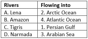
Match the following pairs of Rivers and the Water bodies they are flowing into: 
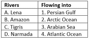

Select the correct answer using the code given below:
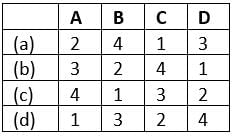
Detailed Solution for Test: Geography - 4 - Question 8


Option (a) is correct:

Test: Geography - 4 - Question 9

Consider the following statements:
1. Coral reefs are formed from the deposition of dead algae.
2. Adam’s bridge consists of shoals.
3. Barrier reefs are formed close to the shore line.
Which of the above statements is/are correct?

Detailed Solution for Test: Geography - 4 - Question 9

• Statement 1 is incorrect: Coral reefs are formed from the deposition of small living organisms called polyps.
• Statement 3 is incorrect: Fringing reefs are formed close to the shore line.
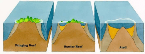
Coral reefs
• Coral polyps are short lived microscopic organisms, which live in colonies. They flourish in shallow, mud free and warm waters. They secrete hard rock like substance. The coral secretion and their skeletons from coral deposits in the form of reefs
• They are mainly of three kinds:
1. Fringing reefs: these reefs grow close to the shore. The fringing reefs can be built from the sea bottom and later extend from the shore having no navigable channel between the shore and the reef.
2. Barrier reefs: these reefs grow close to the shore but have a lagoon that separates it from the slope.
3. Atoll: these are a ring coral that grows on a submerged volcano or mountain. The reef is circular or horseshoe-shaped and encloses a lagoon of water. In some occasions, the reefs can be broken to form navigational channels, some of which are suitable and others are not.

Shoals
• A shoal is a submerged or partially submerged long and narrow ridge, normally of sand, that form in rivers and oceans.
• An almost continuous chain of islands and shoals connect India with Sri Lanka which has been given the name of Adam’s Bridge.
•  The landform occurs when an ocean current, stream, or river facilitates the deposition of granular material and sediment leading to localized shallowing of the water.
• A shoal-sandbar can episodically detach a smaller waterbody from the sea such as brackish water estuaries and marine lagoons.

Test: Geography - 4 - Question 10

Peninsular Rivers are characterised by:

Detailed Solution for Test: Geography - 4 - Question 10

• Peninsular Rivers are characterised by fixed course, absence of meanders and non-perennial flow of water.
The Peninsular Drainage System
• The Peninsular drainage system is older than the Himalayan one. This is evident from the broad, largely-graded shallow valleys, and the maturity of the rivers.
• The Western Ghats running close to the western coast act as the water divide between the major Peninsular Rivers, discharging their water in the Bay of Bengal and as small rivulets joining the Arabian Sea.
• Most of the major Peninsular Rivers except Narmada and Tapi flow from west to east.
• The Chambal, the Sind, the Betwa, the Ken, the Son, originating in the northern part of the Peninsula belong to the Ganga river system.
• The other major river systems of the peninsular drainage are – the Mahanadi the Godavari, the Krishna and the Kaveri.
• Peninsular rivers are characterised by fixed course, absence of meanders and non-perennial flow of water.
• The Narmada and the Tapi, which flow through the rift valley, are exceptions.

Test: Geography - 4 - Question 11

Which of the following is not a feature of the Ozone layer?

Detailed Solution for Test: Geography - 4 - Question 11

The ozone layer acts as a filter for the shorter wavelength and highly hazardous ultraviolet radiation (UVR) from the sun, protecting life on Earth from its potentially harmful effects. The lower the ozone levels, the higher the solar UVR.

Test: Geography - 4 - Question 12

With reference to soil and its formation, which of the following statements is/are correct?:
1. Soil particles are classified as sand, silt and clay.
2. Erosion occurs when sand blows against exposed rocks.
3. The texture of a soil is determined by the soil particle’s shape.

Which of the above statements is/are correct?

Detailed Solution for Test: Geography - 4 - Question 12

Texture is determined by the relative content of sand, silt and clay which depends on SIZE and not shape. 3rd statement is wrong

Test: Geography - 4 - Question 13

Consider the following statements regarding Ganga River System:
1. It consists of perennial rivers only.
2. It consists of rivers originating in the Himalayas only.
Which of the above statements is/are correct?

Detailed Solution for Test: Geography - 4 - Question 13

• Statement 1 is incorrect: It consists of both perennial and non-perennial rivers.
• Statement 2 is incorrect: It consists of rivers originating in the Himalayas in the north and the Peninsula in the south.
Ganga River System
• The Ganga basin covers about 8.6 lakh sq. km area in India.
• The Ganga river system is the largest in India having a number of perennial and non-perennial rivers originating in the Himalayas in the north and the Peninsula in the south, respectively.
• The Son is its major right bank tributary.
• The important left bank tributaries are the Ramganga, the Gomati, the Ghaghara, the Gandak, the Kosi and the Mahananda. The river finally discharges itself into the Bay of Bengal near the Sagar Island.

Test: Geography - 4 - Question 14

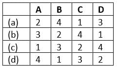
“A contour line is a curve connecting points of equal value”. In this context, match the following: 
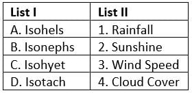

Select the correct answer using the code given below:
Detailed Solution for Test: Geography - 4 - Question 14


Contour Lines in Geography
• Isohyet: For plotting in rainfall maps, places having the same mean annual rainfall are joined by a line called an isohyet.
• Isobars: On maps places of equal pressure reduced to sea level are joined by lines called isobars.
• Isotherm: A line on a map connecting points having the same temperature at a given time or on average over a given period.
• Isohels: On maps, places with equal sunshine duration are joined by isohels.
• Isonephs: On maps, places with an equal degree of cloudiness are joined by lines known as isonephs
• Isotach: An isotach is a line joining points with constant wind speed.
• Isogon: It is the line of constant wind direction.

Test: Geography - 4 - Question 15

Consider the following statements regarding Aichi Targets:
1. These targets were set under Cartagena Protocol to the Convention on Biodiversity.
2. They aim to address the causes of biodiversity loss.

Which of the above statements is/are correct?

Detailed Solution for Test: Geography - 4 - Question 15

• Statement 1 is incorrect: Aichi targets were set under the Nagoya Protocol.
Aichi Targets
• The ‘Aichi Target’ adopted by the Convention on Biological Diversity at its Nagoya conference. In the COP10 meeting, the parties agreed that previous biodiversity protection targets are not achieved, hence there was a need to come up with new plans and targets.
• The short term plan provides a set of 20 ambitious yet achievable targets, collectively known as the Aichi Targets.
Strategic Goal A: Address the underlying causes of biodiversity loss by mainstreaming biodiversity across government and society.
1. Make people aware about the values of biodiversity.
2. Integrated biodiversity values in development + poverty reduction plan.
3. Subsidies which are harmful to biodiversity = and eliminate them, phase them out or reform them.
4. Sustainable production and consumption.
Strategic Goal B: Reduce the direct pressures on biodiversity and promote sustainable use.
1. Reduce the rate of natural habitat loss + forest loss by at least 50%.
2. Reduce overfishing.
3. Agriculture, aquaculture and forestry in sustainable manner.
3. Reduce pollution and excessive use of fertilizer.
4. Prevent invasive alien species (nonnative).
5. Minimise the choral reflow destruction, ocean acidification.
• Strategic Goal C: To improve the status of biodiversity by safeguarding ecosystems, species and genetic diversity.
1. Conserve terrestrial and inland water, coastal – marine areas.
2. Prevent extinction of threatened species.
3. Maintain genetic diversity of agro-plants, domesticated animals and minimising genetic erosion.
Strategic Goal D: Enhance the benefits to all from biodiversity and ecosystem services 14. Safeguard ecosystems for women, tribals, and poor.
1. Combat desertification and restore the degraded ecosystem.
2. Operationalise the nagoya protocol on genetic resources, via national legislations.
• Strategic Goal E: Enhance implementation through participatory planning, knowledge management and capacity building.
1. National biodiversity strategy and action plans – update for participation.
2. Integrate the knowledge of tribal communities.
3. Scientific and technological knowledge sharing application.
4. Financial resources mobilisation.

Test: Geography - 4 - Question 16

Consider the following statements regarding the Hot Springs:
1. They are associated with a volcanic region.
2. ‘Old Faithful’ in Yellowstone National Park of USA is the world’s best known hot spring.
Which of the above statements is/are correct?

Detailed Solution for Test: Geography - 4 - Question 16

• Statement 1 is incorrect: Hot springs may be found in any part of the earth where water sinks deep enough beneath the surface to be heated by the interior forces. They are not necessarily associated with a volcanic region.
• Statement 2 is incorrect: Old Faithful’ in Yellowstone National Park of USA is the world’s best-known geyser (and not hot spring).
Hot Springs
• Hot springs or thermal springs are relatively common than geysers and may be found in any part of the earth where water sinks deep enough beneath the surface to be heated by the interior forces.
•  The water rises to the surface without any explosion. Such springs contain dissolved minerals which may be of some medical value.
• Iceland has thousands of hot springs. Some of them have been harnessed to heat houses, swimming pools, and other domestic purposes. Hot springs and geysers have become tourist attractions e.g. in Japan and Hawaii.
• Old Faithful’ in Yellowstone National Park of USA is the world’s best-known geyser.

Test: Geography - 4 - Question 17

“Though the proportions of different salts remain constant in all oceans, there are salinity variations”. In this context, consider the following statements:
1. The highest salinity is found in equatorial lakes and seas
2. Chandrataal lake is freshwater glacial lake
3. The salinity of the Caspian Sea is lower than the Black Sea
Which of the above statements is/are correct?

Detailed Solution for Test: Geography - 4 - Question 17

• Statement 1 is incorrect: The highest salinity is found in the sub-tropical lakes and seas like Lake Van, Dead Sea, etc.
• Statement 3 is incorrect: Salinity of the Black Sea is lower because many freshwater rivers like the Danube, Dnieper, etc. drain into the Black Sea. It also has relatively mixing of waters with the Mediterranean Sea.
Factors affecting Ocean’s Salinity
• The rate of evaporation:
1. The waters fringing the High-Pressure Belts of the Trade Wind Deserts, between 20° and 30°N. And S., have high salinity because of the high rate of evaporation caused by high temperature and low humidity.
2. The temperate oceans have lower salinity due to the lower tempera ture and a lower rate of evaporation.
• The amount of freshwater added by precipitation, streams, and icebergs:
1. Salinity is lower than the average 35 % in equatorial waters because of the heavy daily rainfall and high relative humidity.
2. Oceans into which huge rivers like the Amazon, Congo, Ganges, Irrawaddy and Mekong drain, have much of their saltiness diluted and have a lower salinity.
3. The Baltic, Arctic, and Antarctic waters have a salinity of less than 32 %o because of the colder climate with little evaporation and because much freshwater is added from the melting of icebergs, as well as by several large poleward-bound rivers, e.g. Ob, Lena, Yenisey, and Mackenzie.
• The degree of water mixing by currents: 
1. In wholly or partially enclosed seas such as the Caspian Sea, Mediterranean Sea, Red Sea, and Persian Gulf, the waters do not mix freely with the ocean water and they are not penetrated by ocean currents. Salinity is high, often over 37%.
2. In areas of inland drainage without links with the oceans e.g. the Caspian Sea, continuous evaporation under an almost cloudless sky causes the accumulation of salts around the shores.
3. In the open oceans where currents freely fl ow, salinity tends to be near the average 35% or even a little lower.
4. The range of salinity is negligible where there is free mixing of water by surface and sub-surface currents. Therefore salinity of Southern hemispherical waters is less than northern hemispherical waters.
• Other factors: Presence of warm and cold currents also affect salinity. Salinity is more where there are warm currents. Similarly, cold currents reduce the salinity in their region. In areas of upwelling, salinity tends to be lower.
• Glacial Lakes in high altitudes are saline because at higher altitudes, pressure decreases which increase the rate of evaporation thereby increasing the salinity. E.g. Pan gong Lake, Tso Moriri lake, etc.

Test: Geography - 4 - Question 18

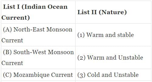
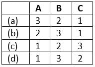
Match the following:


Select the correct answer from the code given below:
Detailed Solution for Test: Geography - 4 - Question 18


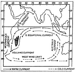
Indian Ocean Currents
• North-East monsoon current:
1. The North-east monsoon winds blow from land to the ocean during winter season in the northern hemisphere and thus westward blowing north-east monsoon currents are produced between Andaman and Somali.
2. The currents are cold and unstable.
3. The currents of Indian Ocean during winter:

• South-West Monsoon Current:
1. There is complete reversal in the direction of monsoon winds during summer season. In other words, north-easterly direction of winter monsoon winds becomes southwesterly during summer season in the northern hemisphere.
2. This reversal of direction of monsoon winds also reverses the direction of ocean currents of Indian Ocean during summer season. Northeast monsoon ocean currents disappear and south-west monsoon ocean currents are developed.
3. These currents are warm and unstable.
4. Currents of Indian Ocean during summer:
• Mozambique Current:
1. One branch of the southern Indian equatorial current moves southward through Mozambiqe Channel known as Mozambiqe current.
2. This current joins the Agulhas current near 30°S latitude and moves upto the southern tip of Africa and is ultimately diverted eastward.
3. These currents are warm and stable.

Test: Geography - 4 - Question 19

Which of the following sources is not a direct source of information about the interior of the Earth?

Detailed Solution for Test: Geography - 4 - Question 19

• The materials obtained from meteors act as an indirect source of information about the interior of the Earth.
Sources of information about the interior of the Earth
• There are two types of sources of information about the interior of the Earth: Direct and Indirect.
Direct sources
1. The sources which are obtained directly from Earth’s interior are called Direct sources.
2. These include materials obtained from Mining or from scientific projects such as “Deep Ocean Drilling Project” & “Integrated Ocean Drilling Project” and the Magma/Lava obtained from a volcanic eruption, etc.
3. The drilling projects provide better sources of information than mining because they can provide materials from the depth as far as 12 km while in mining, going beyond 3-4 km depth is not possible due to high temperature and pressure at this depth.
Indirect sources
1. These are the sources that are not obtained directly from the Earth’s interior but help in the understanding of the same.
2. These include earthquake waves; materials obtained from meteors; earth’s gravitation, magnetic & seismic activities and the variability of temperature, pressure, and density of the Earth, etc.
3. Although the materials obtained from meteors are not from the Earth these are similar to the Earth hence, they provide valuable information.

Test: Geography - 4 - Question 20

Consider the following statements regarding Isotherms:
1. They are generally parallel to the latitude. 
2. In January, the isotherms deviate to the south over the ocean and to the north over the continent.
Which of the above statements is/are correct?

Detailed Solution for Test: Geography - 4 - Question 20

• Statement 2 is incorrect: In January, the isotherms deviate to the north over the ocean and to the south over the continent.
Isotherms
• The isotherms are lines joining places having an equal temperature.
• In general, the effect of the latitude on temperature is well pronounced on the map, as the isotherms are generally parallel to the latitude.
• The deviation from this general trend is more pronounced in January than in July, especially in the northern hemisphere.
• In the northern hemisphere, the land surface area is much larger than in the southern hemisphere. Hence, the effects of landmass and the ocean currents are well pronounced.
• In January, the isotherms deviate to the north over the ocean and to the south over the continent.
• In July, the isotherms generally run parallel to the latitude.

Test: Geography - 4 - Question 21

With reference to Peninsular rivers, consider the following statements:
1. Sardar Sarovar Dam is built on Mahanadi River.
2. Krishna River rises from Trimbak Plateau of North Sahyadri.
3. Manjira is the left bank tributary of Godavari.
Which of the above statements is/are correct?

Detailed Solution for Test: Geography - 4 - Question 21

• Statement 1 is incorrect: Sardar Sarovar Dam is built on Narmada River.
• Statement 2 is incorrect: Godavari River rises from Trimbak Plateau of North Sahyadri.
• Statement 3 is incorrect: Manjira is the right bank tributary of Godavari.
Peninsular rivers
• Narmada river:
1. The Narmada, also called the Rewa, is a river in central India and the fifth longest river in the Indian subcontinent. It is the third longest river that flows entirely within India, after the Godavari, and the Krishna.
2. It originates from the hills of Amarkantak in Madhya Pradesh. It is also known as Life Line of Madhya Pradesh for its huge contribution to the state of Madhya Pradesh in many ways. It forms the famous Dhuadhar falls.
3. The Sardar Sarovar Dam is a gravity dam on the river near Navagam, Gujarat. Four states, Gujarat, Madhya Pradesh, Maharashtra and Rajasthan, receive water and electricity supplied from the dam.
4. It forms the traditional boundary between North India and South India and flows westwards in the rift valley before draining through the Gulf of Cambay into the Arabian Sea.
• Godavari River:
1. The Godavari is the second longest river in India after the river Ganges having its source at Trimbak Plateau of North Sahyadri.
2. It is known as Dakshin Ganga or Vridha Ganga (Old Ganga).
3. Major tributaries are: Manjira, Penganga, Wardha, Wainganga, Indrnvati, Sabari Pranhita.
4. Of these tributaries, Manjira is the right bank tributary of Godavari.

Test: Geography - 4 - Question 22

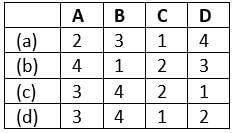
Fold Mountains are formed by the large scale lithospheric movements in the earth’s crust. Which of the following factors lead to the formation of Fold Mountains?
1. Increased load of the overlaying rocks.
2. Flow movements in the Mantle.
3. Magmatic intrusions into the crust.
Select the correct answer using the code given below:
Detailed Solution for Test: Geography - 4 - Question 22

• All statements are correct
Fold Mountains
• Fold Mountains are caused by large-scale lithospheric movements. When tensions are set up in the earth’s crust such tension may be due to the increased load of the overlaying rocks, flow movements in the mantle, magmatic intrusions into the crust, or the expansion or contraction of some part of the earth.
1. Fold Mountains are created where two or more of Earth’s tectonic plates are pushed together. At these colliding, compressing boundaries, rocks and debris are warped and folded into rocky outcrops, hills, mountains, and entire mountain ranges.
2. Fold Mountains are created through a process called orogeny. An orogenic event takes millions of years to create a fold mountain.
3. Fold Mountains occur when two tectonic plates collide at a convergent plate boundary, causing the crust to over thicken. This process forces the less dense crust to float on top of the denser mantle rocks – with material being forced upwards to form hills, plateaus or mountains – while a greater volume of material is forced downward into the mantle.
4. Some of the examples of fold mountains are Andes, Himalayas, Rockies etc.

Test: Geography - 4 - Question 23

With reference to Koeppen’s climatic classification, consider the following statements:
1. It is an empirical classification.
2. Koeppen used certain values of temperature and precipitation for classifying the climate.
Which of the above statements is/are correct?

Detailed Solution for Test: Geography - 4 - Question 23

• Both statements are correct
Koeppen’s Climatic Classification
• Koeppen’s Classification is the most widely used classification of climate.
• It is an empirical classification based on mean annual and means monthly temperature and precipitation data. He selected certain values of temperature and precipitation and related them to the distribution of vegetation and used these values for classifying the climates.
• He introduced the use of capital and small letters to designate climatic groups and types.
• There are 3 levels to his classification:
1) Level 1: - Koeppen recognized five major climatic groups; four of them are based on temperature and one on precipitation. The capital letters: A, C, D, and E delineate humid climates and B dry climates. The B- Dry Climates are subdivided using the capital letters S for steppe or semi-arid and ‘W’ for deserts; ‘h’ for sub-tropical regions and ‘k’ for temperate regions.
2) Level 2: -The climatic groups are subdivided into types, designated by small letters, based on seasonality of precipitation and temperature characteristics. The seasons of dryness are indicated by the small letters: f, m, w, and s. Here f corresponds to no dry season, m - monsoon climate, w- winter dry season and s - summer dry season.
3) Level 3: - The small letters a, b, c, and d refer to the degree of severity of temperature.
4. In his later modifications, he used the letter ‘m’ for monsoon type climate and ‘H’ to depict highlands.

Test: Geography - 4 - Question 24

Madden-Julian Oscillation (MJO) is a coupling similar to that of El-Nino Southern Oscillation (ENSO) but differs from it in many ways. Consider the following statements regarding Madden-Julian Oscillation:
1. Unlike El-Nino Southern Oscillation which is a travelling pattern, MaddenJulian Oscillation is a standing pattern.
2. It is good for Indian sub-continent as it increases the amount of rainfall during monsoon when it establishes on Indian Ocean.
Which of the above statements is/are correct?

Detailed Solution for Test: Geography - 4 - Question 24

• Statement 1 is incorrect: Unlike El-Nino Southern Oscillation which is a standing pattern Madden-Julian Oscillation is a travelling pattern.
Madden Julian Oscillation (MJO)
• The Madden Julian Oscillation (MJO) is a global phenomenon which can be defined as an eastward moving ‘pulse’ of clouds, rainfall, winds and pressure near the equator that typically recurs every 30 to 60 days. It’s a traversing phenomenon and is most prominent over the Indian and Pacific Oceans.
• It has eight phases and when it is over the Indian Ocean during the Monsoon season, it brings good rainfall over the Indian subcontinent.
• On the other hand, when it witnesses a longer cycle and stays over the Pacific Ocean, MJO brings bad news for the Indian Monsoon.
• Periodicity of MJO varies between approximately 30-60 days. Because of this pattern, the Madden–Julian oscillation is also known as the 30-60 day oscillations or intra-seasonal oscillations.
• Apart of Indian Monsoon, MJO affects rainfall pattern of different parts of the world.

Test: Geography - 4 - Question 25

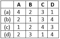
Which of the following process(es) can be best associated with Diastrophism?
1. Mountain building through severe folding of the earth’s crust.
2. The heat generation by the radioactive elements in earth’s interior. 
3. Weathering, mass wasting, erosion and deposition.
Select the correct answer using the code given below:
Detailed Solution for Test: Geography - 4 - Question 25

• Statement 3 is incorrect: Diastrophism is an endogenic geomorphic processes, while weathering, mass wasting, erosion and deposition are exogenic geomorphic processes.
Earth Movements
• The endogenic and exogenic forces causing physical and chemical changes on earth surface are known as geomorphic processes.
• Diastrophism, also called tectonism, large-scale deformation of Earth’s crust by natural processes, which leads to the formation of continents and ocean basins, mountain systems, plateaus, rift valleys, and other features by mechanisms such as lithospheric plate movement (that is, plate tectonics), volcanic loading, or folding.
• It includes:
1. Orogenic processes involving mountain building through severe folding and affecting long and narrow belts of the earth’s crust;
2. Epeirogenic processes involving uplift or warping of large parts of the earth’s crust;
3. Earthquakes involving local relatively minor movements;
4. Plate tectonics involving horizontal movements of crustal plates.
5. The heat generation by the radioactive elements in earth’s interior leads to movements of Magma and tectonic activities. 
•  Diastrophism and volcanism are endogenic geomorphic processes. Weathering, mass wasting, erosion and deposition are exogenic geomorphic processes.

Test: Geography - 4 - Question 26

Which of the following constitute the soil forming processes?
1. Soil enrichment
2. Loss of material from the soils
3. Translocation of materials
4. Transformation of materials
Select the correct answer using the code given below:

Detailed Solution for Test: Geography - 4 - Question 26

•  All statements are correct
Soil Forming Processes
• The events and processes, whether physical, chemical or biological, which help in the formation of soils in a given region are called pedogenic processes or soil forming processes they are classified into four groups. The formation of soil is, in fact, the result of the proportions of these processes over a definite time. The following are the soil forming processes:
• Soil enrichment
• Loss of materials from the soils
• Translocation of materials
• Transformation of materials

Test: Geography - 4 - Question 27

Consider the following statements regarding solstices:
1. The summer solstice for the northern hemisphere occurs when the sun is directly over the tropic of cancer.
2. Solstices occur because the Earth’s axis of rotation is tilted.
3. Winter solstice marks the shortest day and longest night.
Which of the above statements are correct?

Detailed Solution for Test: Geography - 4 - Question 27

• All statements are correct
Solstice:
• The summer solstice occurs at the moment the earth’s tilt toward the sun is at a maximum. Therefore, on the day of the summer solstice, the sun appears at its highest elevation with a noontime position that changes very little for several days before and after the summer solstice.  
• The summer solstice occurs when the sun is directly over the Tropic of Cancer, which is located at 23.5° latitude North and runs through Mexico, the Bahamas, Egypt, Saudi Arabia, India, and southern China.  For every place north of the Tropic of Cancer, the sun is at its highest point in the sky and this is the longest day of the year.
• The winter solstice marks the shortest day and longest night of the year. In the Northern Hemisphere, it occurs when the sun is directly over the Tropic of Capricorn, which is located at 23.5° south of the equator and runs through Australia, Chile, southern Brazil, and northern South Africa.
• Solstices occur because Earth’s axis of rotation is tilted about 23.4 degrees relative to Earth’s orbit around the sun.
This tilt is what drives our planet’s seasons, as the Northern and Southern Hemispheres get unequal amounts of sunlight over the course of a year. From March to September, the Northern Hemisphere is tilted more toward the sun, driving its spring and summer. From September to March, the Northern Hemisphere is tilted away, so it feels autumn and winter. The Southern Hemisphere’s seasons are reversed.

Test: Geography - 4 - Question 28

Consider the following statements regarding the Depositional landforms of Groundwater:
1. Stalactites rise up from the floor of the caves.
2. Stalagmites may develop a miniature crater-like depression. 
Which of the above statements is/are incorrect?

Detailed Solution for Test: Geography - 4 - Question 28

• Statement 1 is incorrect: Stalagmites rise up from the floor of the caves.
Depositional Landforms by Groundwater
• Many depositional forms develop within the limestone caves.
• The chief chemical in limestone is calcium carbonate (calcite) which is easily soluble in carbonated water (carbon dioxide absorbed rainwater). This calcium carbonate is deposited when the water carrying it in the solution evaporates or loses its carbon dioxide as it trickles over rough rock surfaces.
• Stalactites hang as icicles of different diameters. Normally they are broad at their bases and taper towards the free ends showing up in a variety of forms.
• Stalagmites rise up from the floor of the caves. In fact, stalagmites form due to dripping water from the surface or through the thin pipe, of the stalactite, immediately below it.
• Stalagmites may take the shape of a column, a disc, with either a smooth, rounded bulging end or a miniature crater-like depression.
• The stalagmite and stalactites eventually fuse to give rise to columns and pillars of different diameters.

Test: Geography - 4 - Question 29

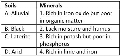
Match the following:


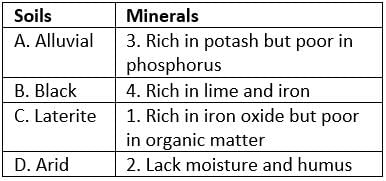
Select the correct answer using the code given below:

Detailed Solution for Test: Geography - 4 - Question 29


Soils and their content
• Alluvial soil is widespread in the northern plains and the river valleys. The alluvial soil varies in nature from sandy loam to clay. They are generally rich in potash but poor in phosphorous.
•  The Black soils are rich in lime, iron, magnesia, and alumina. They also contain potash. But they lack in phosphorus, nitrogen and organic matter. The color of the soil ranges from deep black to grey.
• Laterite soils are poor in organic matter, nitrogen and phosphate and calcium, while iron oxide and potash are in excess.
• Arid or desert soil lack moisture and humus. Nitrogen is insufficient and the phosphate content is normal. 

Test: Geography - 4 - Question 30

Match the following:


Select the correct answer using the code given below:
Detailed Solution for Test: Geography - 4 - Question 30


Glaciers and Rivers Associated with it:
Indus River System: It is one of the largest river basins of the world, covering an area of 11,65,000 sq. km (in India it is 321, 289 sq. km and a total length of 2,880km (in India 1,114 km). The Indus also known as the Sindhu, is the westernmost ofthe Himalayan rivers in India. It originates from a glacier near Bokhar Chu (31°15’ N latitude and 81°40’ E longitude) in the Tibetan region at an altitude of 4,164 m in the Kailash Mountain range. In Tibet, it isknown as ‘Singi Khamban; or Lion’s mouth. After flowing in the northwest direction between the Ladakh and Zaskar ranges, it passes through Ladakh and Baltistan. It cuts across the Ladakh range, forming a spectacular gorge near Gilgit in Jammu and Kashmir. It enters into Pakistan near Chilasin the Dardistan region. Find out the area known as Dardistan.
The Ganga is the most important river of India both from the point of view of its basin and cultural significance. It rises in the Gangotri glacier near Gaumukh (3,900 m)in the Uttarkashi district of Uttarakhand. Here, it is known as the Bhagirathi. It cutsthrough the Central and the Lesser Himalayas in narrow gorges. At Devprayag, the Bhagirathi meets the Alaknanda; hereafter, it is known as the Ganga.
The Brahmaputra, one of the largest rivers of the world, has its origin in the Chemayungdung glacier of the Kailash range near the Mansarovar lake.
Teesta river originates from Zemu glaciers.

Information about Test: Geography - 4 Page
In this test you can find the Exam questions for Test: Geography - 4 solved & explained in the simplest way possible. Besides giving Questions and answers for Test: Geography - 4, EduRev gives you an ample number of Online tests for practice

Top Courses for UPSC

Download as PDF

Top Courses for UPSC