UPSC Exam  >  UPSC Tests  >  Test: Geography - 5 - UPSC MCQ

Test: Geography - 5 - UPSC MCQ


Test Description

30 Questions MCQ Test - Test: Geography - 5

Test: Geography - 5 for UPSC 2024 is part of UPSC preparation. The Test: Geography - 5 questions and answers have been prepared according to the UPSC exam syllabus.The Test: Geography - 5 MCQs are made for UPSC 2024 Exam. Find important definitions, questions, notes, meanings, examples, exercises, MCQs and online tests for Test: Geography - 5 below.
Solutions of Test: Geography - 5 questions in English are available as part of our course for UPSC & Test: Geography - 5 solutions in Hindi for UPSC course. Download more important topics, notes, lectures and mock test series for UPSC Exam by signing up for free. Attempt Test: Geography - 5 | 30 questions in 36 minutes | Mock test for UPSC preparation | Free important questions MCQ to study for UPSC Exam | Download free PDF with solutions
Test: Geography - 5 - Question 1

With reference to the Sea Floor Spreading, consider the following statements:
1. It is a process in which new oceanic crust forms gradually through continuous volcanic eruptions.
2. The force involved in this process is convective current.
Which of the above statements is/are correct?

Detailed Solution for Test: Geography - 5 - Question 1

• Both statements are correct
Sea Floor Spreading
• Post Continental drift theory revealed the following facts:
1. It was realized that all along the mid oceanic ridges, volcanic eruptions are common and they bring huge amounts of lava to the surface in this area
2. The rocks equidistant on either sides of the crest of mid-oceanic ridges show remarkable similarities in terms of period of formation, chemical compositions and magnetic properties.
3. The age of the rocks increases as one moves away from the crest of the Ridges.
4. The ocean crust rocks are much younger than the continental rocks. The age of rocks in the oceanic crust is nowhere more than 200 million years old while some of the continental rock formations are as old as 3,200 million years.
5. The sediments on the ocean floor are unexpectedly very thin.
6. The deep trenches have deep-seated earthquake occurrences while in the mid oceanic ridge areas, the quake foci have shallow depths.
• These facts led Harry Hess to propose his hypothesis, known as the “sea floor spreading”. The force of the Sea floor spreading was found to be Convective current as postulated by Arthur Holmes.
• Magma continuously wells upwards at the mid-oceanic ridges producing currents of magma flowing in opposite directions and thus generating the forces that pull the sea floor apart at the mid-oceanic ridges.
• As the ocean floor is spread apart, cracks appear in the middle of the ridges allowing molten magma to surface through the cracks to form the newest ocean floor. Here, new crust is generated.
• As the ocean floor moves away from the midoceanic ridge eventually comes into contact with a continental plate at convergent boundary, subducted underneath the continent and the crustal mass is consumed here.
• Finally, the lithosphere drives back into the asthenosphere where it returns to a heated state.

Test: Geography - 5 - Question 2

Which of the following statements regarding El Nino is/are correct?
1. El Nino results into high pressure over west Pacific and thus causes droughts in Eastern Australia.
2. El Nino affects the weather conditions of the entire tropical region.
Select the correct answer using the code given below:

Detailed Solution for Test: Geography - 5 - Question 2

• Both statements are correct
El Nino and La Nina
• El Nino is a phenomenon in the equatorial Pacific characterized by appearance of warm currents off the coast of Peru in the Eastern Pacific.
• The word EI-Nino means ‘Child Christ’ because this current appears around Christmas in December
• EI-Nino is merely an extension of the warm equatorial current which increases the temperature of water on the Peruvian coast by 10°C resulting into: 
1. The distortion of equatorial atmospheric circulation.
2. Irregularities in the evaporation of sea water.
• It affects the weather conditions of the entire tropical region
• The appearance of warm waters in eastern pacific  results into reduced amounts of planktons which further reduces the number of fish in sea.
• During El Nino, the pressure conditions over east and west Pacific reverses i.e. Low Pressure in East Pacific and High Pressure in west Pacific resulting into higher rainfalls in Eastern Pacific and droughts/scanty rainfall in West Pacific/Asia.
• El Nino has been negatively correlated to Indian Monsoons as it has been observed that monsoons are deficient in India during El Nino years.
• La Nina is the opposite of El Nino characterized by occurrence of cooler waters in East Pacific.
•  The word La Nina means ‘Little Girl’.
• Since the waters are colder than normal in East Pacific, there is no reversal of pressure conditions; instead the normal conditions get intensified during La Nina years.

1 Crore+ students have signed up on EduRev. Have you? Download the App
Test: Geography - 5 - Question 3

Consider the following statements regarding Jute Cultivation:
1. The suitable climate for growing jute is a warm and wet climate.
2. Sandy loams and clay loams are most suitable for jute cultivation.
Which of the above statements is/are correct?

Detailed Solution for Test: Geography - 5 - Question 3

• Statement 2 is incorrect: New grey alluvial  soil of  good  depth receiving  silt from  annual  floods is most suitable  for jute. However, jute is grown widely in sandy loams and clay loams specially river basins.
Jute Cultivation
• The suitable climate for growing jute is a warm and wet climate.
• Temperatures ranging from 25-30 °C and relative humidity of 70%–90% are favorable for successful cultivation.
• Minimum rainfall required for jute cultivation is 1000 mm. It requires 160-200 cm of rainfall weekly with extra needed during the sowing period.
• Soil type : New grey  alluvial  soil of  good  depth receiving  silt  from annual  floods is most suitable  for  jute However, jute is grown widely in sandy looms and clay loams specially river basins.
• PH range between 4.8-5.8 is best for its cultivation so Jute cultivation in red soils may require high dose of manure.
• Plain land or gentle slope or low land is ideal for jute cultivation. In India, Ganga delta region is excellent for jute cultivation as this region has fertile alluvium soil and favorable temperature along with sufficient rainfall. This fertile geographic region is shared by both Bangladesh and India (mainly West Bengal).
• Main jute producing states- The jute crop is grown in nearly 83 districts of seven states - West Bengal , Assam , Orissa , Bihar , Uttar Pradesh , Tripura and Meghalaya . West Bengal alone accounts for over 50 percent raw jute production.
• Main jute producing countries- The leading world’s jute producing countries are India, Bangladesh, China and Thailand. India is the world’s largest producer of raw jute and jute goods, contributing to over 50 percent and 40 percent respectively of global production.

Test: Geography - 5 - Question 4

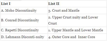
Match the following discontinuities with their positions in interior of the earth:
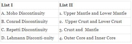
Select the correct answer using the given code below:
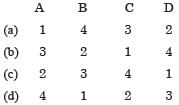
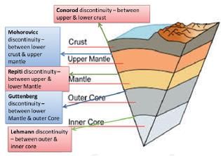
Detailed Solution for Test: Geography - 5 - Question 4

• Option (b) is correct 

The Interior of the Earth

Test: Geography - 5 - Question 5

Consider the following statements with reference to Alluvial Soils:
1. Khadar is the older alluvium deposited away from the flood plains.
2. Bhangar is new alluvium deposited by floods.
Which of the above statements is/are correct?

Detailed Solution for Test: Geography - 5 - Question 5

• Statement 1 is incorrect: Bhangar is the older alluvium deposited away from the flood plains.
• Statement 2 is incorrect: Khadar is the new alluvium and is deposited by floods annually, which enriches the soil by depositing fine silts.
Alluvial Soil
• Alluvial soils are widespread in the northern plains and the river valleys.
• These soils cover about 40 percent of the total area of the country.
• They are depositional soils, transported and deposited by rivers and streams.
• Through a narrow corridor in Rajasthan, they extend into the plains of Gujarat.
• In the Peninsular region, they are found in deltas of the east coast and in the river valleys.
• The alluvial soils vary in nature from sandy loam to clay.
• They are generally rich in potash but poor in phosphorous.
• In the Upper and Middle Ganga plain, two different types of alluvial soils have developed, viz. Khadar and Bhangar.
1. Khadar is the new alluvium and is deposited by floods annually, which enriches the soil by depositing fine silts.
2.  Bhangar represents a system of older alluvium, deposited away from the flood plains.
3.  Both the Khadar and Bhangar soils contain calcareous concretions (Kankars). 

Test: Geography - 5 - Question 6

Consider the following statements regarding the Asteroids:
1. Asteroids are found between the orbits of Mars and Saturn.
2. Asteroids exhibit the process of outgassing while passing close to the sun.
Which of the above statements is/are correct?

Detailed Solution for Test: Geography - 5 - Question 6

• Statement 1 is incorrect: Asteroids are found between the orbits of Mars and Jupiter.
• Statement 2 is incorrect: Comets exhibit the process of Outgassing while passing close to the sun.
Comets
• Comets are the small celestial bodies orbiting the sun, made up of dust and non-volatile grain and ice, while passing close to the sun it releases gas.
• This process is called outgassing.
• The mixture of ice crystals and dust blows from the comet nucleus in the solar wind creating a pair of tails.
• These phenomena are due to effects of solar radiation and the solar winds acting upon the nucleus of the comet.
• Many a times, comets are visible to the naked eye and present a very spectacular sight.
Asteroids
• Asteroids are found between the orbits of Mars and Jupiter.
• These are celestial bodies with sizes ranging from a few meters to hundreds of kilometres of diameter, revolving around the sun.
• They have originated by the disintegration of the planets.
• Their estimated number is around 40,000. 

Test: Geography - 5 - Question 7

Consider the following statements regarding fluvial landforms:
1. Waterfalls are found only in the mountain course of a river.
2. River piracy occurs due to different rate of headward erosion into a river divide.
3. Cataracts are large and deep holes at the base of a waterfall.
Which of the above statements is/are incorrect?

Detailed Solution for Test: Geography - 5 - Question 7

• Statement 1 is incorrect: Waterfalls are liable to occur at any part of the river course.
• Statement 3 is incorrect: Plunge pools are large and deep holes at the base of waterfall.
Landforms in Upper Course
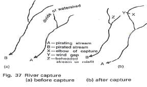
River Capture

• This is also known as river piracy or river beheading. Its development is dependent on the different rate of back-cutting (headward erosion) into a divide.
• For instance, if one side of the divide is of greater gradient or receives more precipitation than the other, stream A will cut back more rapidly than stream B. Its greater erosive power will succeed in enlarging its basin at the expense of the weaker stream. Stream A may eventually break through the divide and capture or pirate stream B.
• The bend at which the piracy occurs is termed as the elbow of capture. The beheaded stream (Z) is called the misfit. The valley below the elbow is the wind gap and can be valuable as a road and rail route.  

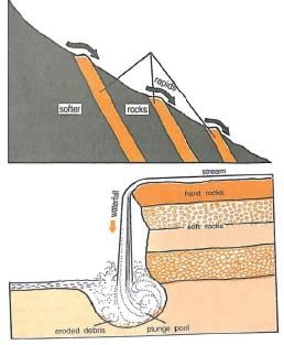
Rapids, Cataracts and Waterfalls
• These are liable to occur at any part of the river course, but they are most numerous in the mountain course where changes of gradient are more abrupt and also more frequent. 
• Due to the unequal resistance of hard and soft rocks traversed by a river, the outcrop of a band of hard rock may cause a river to ‘jump’ or ‘fall’ downs tream. Thus rapids are formed.
• Similar falls of greater dimensions are also referred to as cataracts.
• When rivers plunge down in a sudden fall of some height, they are called waterfalls. Their great force usually wears out a plunge pool beneath.
• Large and deep holes at the base of waterfalls are called plunge pools.

Potholes
• Over the rocky beds of hill-streams more or less circular depressions called potholes form because of stream erosion aided by the abrasion of rock fragments.
• Once a small and shallow depression forms, pebbles and boulders get collected in those depressions and get rotated by flowing water and consequently the depressions grow in dimensions.

Test: Geography - 5 - Question 8

Consider the following statements with reference to winds:
1. Local winds are confined to the lower level of the Stratosphere.
2. Foehn is a strong, dry and warm local wind which develops on the windward side of the Alps.
3. Mistral brings down the temperature below freezing point in areas of their influence.
Which of the above statements is/are correct?

Detailed Solution for Test: Geography - 5 - Question 8

• Statement 1 is incorrect: Local winds are confined to the lower level of the Troposphere.
• Statement 2 is incorrect: Foehn is a strong, dusty, dry and warm local wind which develops on the leeward side of the Alps.
Local Winds
• Local winds develop as a result of local differences in temperature and pressure. they affect small areas and are restricted to the lowest levels of the troposphere.
• Foehn is a hot wind of local importance in the Alps. it is a strong, gusty, dry and warm wind which develops on the leeward side of a mountain range. due to regional pressure gradient, stable air is forced to cross the barrier. Similar kinds of winds in USA and Canada move down the west slopes of the Rockies and are known as Chinooks. it literally means snow eater.
• The mistral flows from the Alps over France towards the Mediterranean Sea. It is very cold and dry wind with high velocity and is channeled through the Rhone valley. Even though the skies are clear, the mistral brings down the temperature below freezing point.

Test: Geography - 5 - Question 9

Consider the following statements regarding the Submarine Trenches and Deeps:
1. These are tectonically formed and are found along the constructive plate margins.
2. The largest number of deeps and trenches are found in the Atlantic Ocean.
Which of the above statements is/are correct?

Detailed Solution for Test: Geography - 5 - Question 9

• Statement 1 is incorrect: These are tectonically formed and are found along the destructive plate margins.
• Statement 2 is incorrect: The largest number of deeps and trenches are found in the Pacific Ocean. 
Submarine Trenches and Deeps
• Oceanic trenches and deeps are topographic depression of the seafloor.
• They are the deepest zones of the ocean basins. 
• These are generally 5500 m deep and are located parallel to the coasts facing the mountains and along the islands.
• These are tectonically formed and are found along the destructive plate margins.
• The largest number of deeps and trenches are found in the Pacific Ocean.
• There is a long chain of deeps and trenches along the eastern and western margins of the Pacific Ocean.
• Aleutian trench, Kuril trench, Japan trench, Mindanao trench and Mariana trench are located on the western margin of the Pacific.
• Atacama and Tonga trenches are located along the eastern margin of the Pacific.
• The Mariana Trench is the deepest with a depth of 11,034 m.
• It is located to the east of Philippines.
• Sunda, near the Java Island and Diamantina, near the south-west Australia are important trenches of the Indian Ocean. 

Test: Geography - 5 - Question 10

Which of the following statements is/are incorrect regarding Caves formation in Karst Topography?
1. Caves formation is prominent in the areas with alternative bed of Shales and Sandstones rocks.
2. In areas, where Limestone are dense and occurring as thick beds, cave formation is prominent.
Select the correct answer using the code given below:
Detailed Solution for Test: Geography - 5 - Question 10

• Both statements are correct
Karst Topography
• In areas where there are alternating beds of rocks (shales, sandstones, quartzites) with limestone or dolomites in between or in areas where lime stones are dense, massive and occurring as thick beds, cave formation is prominent. Water percolates down either through the materials or through cracks and joints and moves horizontally along bedding planes.
• It is along these bedding planes that the limestone dissolves and long and narrow to wide gaps called caves result. There can be a maze of caves at different elevations depending upon the limestone beds and intervening rocks.
• Caves normally have an opening through which cave streams are discharged. Caves having openings at both the ends are called tunnels.

Test: Geography - 5 - Question 11

With reference to Jet Streams, consider the following statements:
1. Jet streams are narrow bands of fast moving winds in the upper levels of atmosphere.
2. They flow from west to east.
Which of the above statements is/are correct?

Detailed Solution for Test: Geography - 5 - Question 11

• Both statements are correct
Jet Streams
• Jet streams are relatively narrow bands of fast moving winds in the upper levels of atmosphere.
• Jet streams follow the boundaries between hot and cold air. Since these boundaries are more pronounced in winters, jet streams are strongest for both the northern and southern hemisphere winters.
• Jet streams flow as part of upper tropospheric circulations which are westerly everywhere i.e. they flow from west to east.
• The strongest jet streams are the polar jets, at 9–12 km above sea level, and the higher altitude and somewhat weaker subtropical jets at 10–16 km. The Northern Hemisphere and the Southern Hemisphere each have a polar jet and a subtropical jet.
• Other jet streams also exist. During the Northern Hemisphere summer, easterly jets can form in tropical regions, typically where dry air encounters more humid air at high altitudes.
• The sub-tropical Westerly Jet Stream (flows over Indian sub-continent during winters) and Tropical easterly Jet Stream (flows over Indian Peninsula during summers) influence the monsoons in India.
• The western cyclonic disturbances which enter the Indian subcontinent from the west and the northwest during the winter months originate over the Mediterranean Sea and are brought into India by the westerly jet stream. An increase in the prevailing night temperature generally indicates an advance in the arrival of these cyclones disturbances.
• The easterly jet stream steers the tropical depressions into India. These depressions play a significant role in the distribution of monsoon rainfall over the Indian subcontinent.

Test: Geography - 5 - Question 12

Which of the following statements is/are correct regarding Block Mountains?
1. These Mountains are the result of compressive forces, triggered by the endogenetic forces.
2. These are also called Horst Mountains.
Select the correct answer using the code given below:

Detailed Solution for Test: Geography - 5 - Question 12

• Statement 1 is incorrect: These mountains originate due to the forces of tension (tensile forces) leading to the formation of rift valleys.
Fold Mountains:
• These Mountains are the result of compressive forces, triggered by the endogenetic forces. When the rocks on the surface of the earth are folded due to the forces generated within the earth, the resultant mountains are called Fold Mountains are the highest and most extensive mountains of the world.
• These mountains are characterized by more developed system of anticlines and synclines wherein folds are arranged ina wave-like pattern.
• The Himalayas, Alps, Ural, Rock I.e., Andes, Atlas etc. are some examples of Fold Mountains.
Block Mountains:
• These Mountains originate due to the forces of tension (tensile forces) leading to the formation of rift valleys.
• These are also known as Fault Block Mountains, as they are the result of faulting caused by tensile forces.
• Block Mountains represent the upstanding pans of the ground between two faults on either side of a rift valley or a Graben.
• Yet another name given to block mountains is Horst mountains. 
• Sierra Nevada mountain of California, USA is considered to be the most extensive block mountain of the world.
• Other examples of block mountains are Wasatch Range in the Utah province of USA, Vosges and Black Forest mountains of Europe.
• Rhine valley is formed due to submergence of its middle part. Salt Range of Pakistan is also an example of Block Maintain.

Test: Geography - 5 - Question 13

Which of the following features are created by Himalayan Rivers in their mountainous course?
1. Gorges
2. V-shaped Valleys
3. Ox-bow Lakes
4. Waterfalls
Select the correct answer using the code given below:

Detailed Solution for Test: Geography - 5 - Question 13

• Statement 3 is incorrect: Ox-bow lakes are created by Himalayan Rivers in plain areas.
The Himalayan Drainage
• The Himalayan drainage system has evolved through a long geological history.
• It mainly includes the Ganga, the Indus and the Brahmaputra river basins. Since these are fed both by melting of snow and precipitation, rivers of this system are perennial.
• These rivers pass through the giant gorges carved out by the erosional activity carried on simultaneously with the uplift of the Himalayas.
• Besides deep gorges, these rivers also form V-shaped valleys, rapids and waterfalls in their mountainous course.
• While entering the plains, they form depositional features like flat valleys, ox-bow lakes, flood plains, braided channels, and deltas near the river mouth.
• In the Himalayan reaches, the course of these rivers is highly tortous, but over the plains they display a strong meandering tendency and shift their courses frequently.
• River Kosi, also known as the ‘sorrow of Bihar’, has been notorious for frequently changing its course.

Test: Geography - 5 - Question 14

Consider the following statements regarding the factors affecting soil formation:
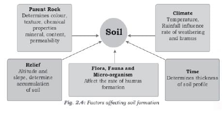
1. The composition of the soil profile is directly influenced by the composition of the parent rocks.
2. Climate determines the thickness of soil profile.
Which of the above statements is/are correct?

Detailed Solution for Test: Geography - 5 - Question 14

• Statement 2 is incorrect: Time duration determines the thickness of soil profile.

Test: Geography - 5 - Question 15

Which of the following statements are correct regarding Suitable conditions for wheat cultivation in India:
1. Wheat thrives well in areas receiving an annual rainfall of about 75 cm.
2. The temperature should be high at the time of sowing.
Select the correct answer using the code given below:

Detailed Solution for Test: Geography - 5 - Question 15

• Statement 2 is incorrect: The temperature should be low at the time of sowing but as the harvesting time approaches higher temperatures are required for proper ripening of the crop. 
Suitable conditions for Wheat Cultivation in India: 
• Wheat is an important food-grain of India and is the staple food of millions of Indians, particularly in the northern and north western parts of the country.
Conditions of Growth:
• Wheat is a rabi crop which is sown in the beginning of winter and is harvested in the beginning of summer.
• The time of sowing and harvesting differs in different regions due to climatic variations.
• The sowing of wheat crop normally begins in the September-October in Karnataka, Maharashtra, Andhra Pradesh, Madhya Pradesh and West Bengal; October November in Bihar, Uttar Pradesh, Punjab, Haryana and Rajasthan and November -December in Himachal Pradesh and Jammu & Kashmir.
• The harvesting is done in January- February in Karnataka, Andhra Pradesh, M.P., and in West Bengal; March-April in Punjab, Haryana, U.P. and Rajasthan and in April May in Himachal Pradesh and J&K.
• The growing period is variable from one agro climatic zone to other that effects the vegetative and reproductive period leading to differences in potential yield.
• The important factors affecting the productivity are seeding time and methodology, crop establishment and climatic conditions during the growing season.
• Wheat is primarily a crop of mid-latitude grasslands and requires a cool climate with moderate rainfall.
• The ideal wheat climate has winter temperature 10° to 15°C and summer temperature varying from 21°C to 26°C.
• The temperature should be low at the time of sowing but as the harvesting time approaches higher temperatures are required for proper ripening of the crop.
• But sudden rise in temperature at the time of maturity is harmful.
• Wheat thrives well in areas receiving an annual rainfall of about 75 cm.
Annual rainfall of 100 cm is the highest limit of wheat cultivation. The isohyet of 100 cm marks the boundary between wheat growing areas on one hand and rice growing areas on the other.
• In areas of less than 50 cm annual rainfall, irrigation is necessary for its successful growth.
• In fact, wheat can be grown in areas with as little as 20-25 cm annual rainfall provided proper irrigation faculties are available.

Test: Geography - 5 - Question 16

Consider the following statements regarding Limestones:
1. Limestone is a sedimentary rock of organic origin.
2. Dolomite is a type of limestone where magnesium is present along with calcite.
3. During orogeny, limestone recrystallizes into shale.
Which of the above statements is/are correct?

Detailed Solution for Test: Geography - 5 - Question 16

• Statement 3 is incorrect: During orogeny, limestone recrystallizes into marble.
Limestone and Chalk
• Limestone and chalk are sedimentary rocks of organic origin. They are derived from the accumulation of corals and shells in the sea.
• Limestone, in its pure state, is made up of calcite or calcium carbonate. However, if magnesium is also present, it is termed as dolomite.
• Chalk is a very pure form of limestone: white and soft.
• Limestone is soluble in rain-water, which, with carbon dioxide from the air, forms a weak acid.
• There can be faulting and fracturing of the crust through the processes of orogeny, epeirogeny, earthquakes, and plate tectonics. All these processes cause pressure, volume and temperature (PVT) changes which in turn induce metamorphism of rocks. Example: During regional metamorphism that occurs during the mountain building process (orogeny), limestone recrystallizes into marble.

Test: Geography - 5 - Question 17

Consider the following statements regarding Inter-Tropical Convergence Zone (ITCZ):
1. It is the zone of clam and windless weather.
2. It generates vigorous thunderstorms over large areas.
Which of the above statements is/are correct?

Detailed Solution for Test: Geography - 5 - Question 17

• Both statements are correct
Inter-Tropical Convergence Zone (ITCZ)
• ITCZ is a low pressure zone located at the equator where trade winds converge, and so, it is a zone where air tends to ascend.
• It is characterized by convective activity which generates often vigorous thunderstorms over large areas. It is most active over continental land masses by day and relatively less active over the oceans.
• It was known by sailors as the doldrums or the calms because of its monotonous, windless weather.
• In July, the ITCZ is located around 20°N25°N latitudes (over the Gangetic plain), sometimes called the monsoon trough. This monsoon trough encourages the development of thermal low over north and northwest India.
• North –South shifting of ITCZ during summers and winters lead to reversal in wind direction.

Test: Geography - 5 - Question 18

Which of the following statements is/are correct regarding National Clean Air Programme (NCAP)?
1. It aims to reduce particulate matter (PM) pollution by 20-30% in at least 102 cities by 2024.
2. Most of the cities chosen under this initiative are Tier-One cities.
Select the correct answer using the code given below:

Detailed Solution for Test: Geography - 5 - Question 18

• Statement 2 is incorrect: With the exception of Delhi, Mumbai, Kolkata and Bengaluru, most of those chosen are tier two cities.
National Clean Air Programme
• The Centre has launched National Clean Air Programme (NCAP) to reduce particulate matter (PM) pollution by 20-30% in at least 102 cities by 2024.
• It will provide the States and the Centre with a framework to combat air pollution.
NCAP
• It is a pollution control initiative launched by the Ministry of Environment to cut the concentration of coarse (particulate matter of diameter 10 micrometer or less, or PM10) and fine particles (particulate matter of diameter 2.5 micrometer or less, or PM2.5) by at least 20% in the next five years, with 2017 as the base year for comparison.
•  Following reports of WHO and the air quality data obtained, 102 cities from 23 States and UTs have been chosen as non-attainment cities. With the exception of Delhi, Mumbai, Kolkata and Bengaluru, most of those chosen are tier two cities.
Participatants
•  Apart from experts from the industry and academia, the programme is expected to be collaboration between the Ministry of Road Transport and Highways, Ministry of Petroleum and Natural Gas, Ministry of New and Renewable Energy, Ministry of Heavy Industry, Ministry of Housing and Urban Affairs, Ministry of Agriculture, Ministry of Health, NITI Aayog, and Central Pollution Control Board.

Test: Geography - 5 - Question 19

Consider the following statements about the Northern Plain of India:
1. They are formed by the alluvial deposits brought by the rivers – the Indus, the Ganga, and the Brahmaputra.
2. It supports a variety of crops like wheat, rice, sugarcane and jute.
Which of the above statements is/are correct?

Detailed Solution for Test: Geography - 5 - Question 19

• Both statements are correct
The Northern Plains of India
• The northern plains are formed by the alluvial deposits brought by the rivers – the Indus, the Ganga, and the Brahmaputra along with their tributaries. These plains extend approximately 3,200 km from the east to the west.
• The average width of these plains varies between 150-300 km.
• The maximum depth of alluvium deposits varies between 1,000-2,000 m. From the north to the south, these can be divided into three major zones: the Bhabar, the Tarai and the alluvial plains.
• The alluvial plains can be further divided into the Khadar and the Bhangar.
• River valley plains have a fertile alluvial soil cover which supports a variety of crops like wheat, rice, sugarcane and jute, and hence, supports a large population.

Test: Geography - 5 - Question 20

The rising and the setting sun appears red due to the phenomenon of:

Detailed Solution for Test: Geography - 5 - Question 20

• Option (a) is correct: The red colour of the rising and the setting sun is due to the phenomenon of Scattering of light.
The Passage of Solar Radiation through the Atmosphere
• The atmosphere is largely transparent to short wave solar radiation. The incoming solar radiation passes through the atmosphere before striking the earth’s surface.
• Within the troposphere, water vapour, ozone and other gases absorb much of the near infrared radiation.
• Very small-suspended particles in the troposphere scatter visible spectrum both to the space and towards the earth surface. This process adds colour to the sky. 
• The red colour of the rising and the setting sun and the blue colour of the sky are the result of scattering of light within the atmosphere.

Test: Geography - 5 - Question 21

Consider the following statements regarding Particularly Vulnerable Tribal Groups (PVTGs) in India:
1. Andaman & Nicobar is the only UT to consist of PVTGs.
2. PVTGs are categorized by Ministry of Tribal Affairs.
3. Existence of pre-agricultural level of technology is one of the criteria for determining PVTG status.
4. Kota and Toto tribes are included in the list of PVTGs.
Which of the above statements are correct?

Detailed Solution for Test: Geography - 5 - Question 21

• Statement 2 is incorrect: PVTGs are categorized by Ministry of Home Affairs.
Particularly Vulnerable Tribal Groups (PVTGs)
• There are certain tribal communities who have existence of pre-agricultural level of technology, stagnant or declining population growth, extremely low level of literacy and a subsistence level of economy.
• 75 such tribal groups have been categorized by Ministry of Home Affairs as Particularly Vulnerable Tribal Groups (PVTGs). PVTGs reside in 18 States and UT of A&N Islands.
• PVTGs constitute the most vulnerable section among the tribals and largely reside in isolated, remote and difficult areas in small and scattered hamlets.
• The Ministry of Tribal Affairs implements the Scheme of “Development of Particularly Vulnerable Tribal Groups (PVTGs)” exclusively for them. Under the scheme, Conservation-cum-Development (CCD)/Annual Plans are to be prepared by each State/UT for their PVTGs based on their need assessment, which are then appraised and approved by the Project Appraisal Committee of the Ministry. Activities for development of PVTGs are undertaken in Sectors of Education, Health, Livelihood and Skill Development, Agricultural Development, Housing & Habitat, Conservation of Culture etc.

Test: Geography - 5 - Question 22

Which of the following statements are correct about Meanders?
1. These are formed when load-carrying capacity of the river increases drastically.
2. Ox-bow lakes are the result of meandering rivers.
3. Its concave bank is known as cut-off bank and convex bank as slip-off bank.
Select the correct answer using the code given below:

Detailed Solution for Test: Geography - 5 - Question 22

• Statement 1 is incorrect: Meanders are not formed when load carrying capacity of of the river increases drastically.
Depositional Landforms
• The meanders or meandering rivers are the low slope rivers which are not choked with the sediment and move back and forth in a zig-zag order of loops. The meander has thus a serpentine path and it helps in accommodating in extra volume of water.
• As the river enters the plain it twists and turns forming large bends known as meanders. Due to continuous erosion and deposition along the sides of the meander, the ends of the meander loop come closer and closer. In due course of time the meander loop cuts off from the river and forms a cut-off lake, also called an ox-bow lake.
• Its concave bank is known as cut-off bank and convex is slip-off bank.

Test: Geography - 5 - Question 23

With reference to Reforestation, consider the following statements:
1. Reforestation is establishment of trees in an area where no previous tree cover exists.
2. Reforestation can be used to rebuild natural habitats and mitigate global warming.
Which of the above statements is/are correct?

Detailed Solution for Test: Geography - 5 - Question 23

• Statement 1 is incorrect: Reforestation is the natural or intentional restocking of existing forests that have been previously depleted or degraded.
Reforestation
• Reforestation is the natural or intentional restocking of existing forests that have been previously depleted or degraded.
• Reforestation can be used to rebuild natural habitats and ecosystems, mitigate global warming since forests facilitate bio-sequestration of atmospheric carbon dioxide etc.
• Reforestation need not be only used for recovery of accidentally destroyed forests. It is also done intentionally. For e.g. in many counties where pulp and paper industry is dominant, trees are planted to replace those that have been cut down.

Test: Geography - 5 - Question 24

Consider the following statements regarding Tropic of Capricorn:
1. Its northern hemisphere equivalent is Tropic of Cancer.
2. It passes only through South American and African Countries.
3. Atacama Desert, Andes Mountains are located on Tropic of Capricorn.
Which of the above statements is/are correct?

Detailed Solution for Test: Geography - 5 - Question 24

• Statement 2 is incorrect: It passes through South American and African Countries and Australia also.
Tropic of Capricorn
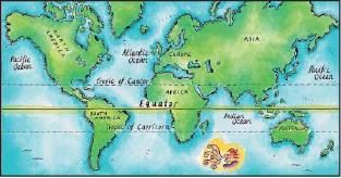
• The Tropic of Capricorn or Southern tropic is one of the five major circles of latitude that mark maps of the Earth.
• It is the parallel of latitude at 23 degrees 26′ 22″ south of the Equator, and is the farthest southern latitude that the sun can appear directly overhead, occurring on the December solstice.
• Its northern hemisphere equivalent is the Tropic of Cancer.
• Latitudes south of the Tropic of Capricorn are in the Southern Temperate Zone.
• The Tropic of Capricorn goes through these countries: Brazil, Paraguay, Argentina, Chile, French Polynesia, Tonga, Australia, Madagascar, Mozambique, South Africa, Botswana and Namibia.
• Atacama Desert, Andes mountains and Antofagasta town are located on Tropic of Capricorn.

Test: Geography - 5 - Question 25

With reference to ‘Asteroid’, which of the following statements is/are correct?
1. The region between Mars and Jupiter is called Asteroid belt.
2. Asteroids are made of dust and ice only.
Select the correct answer using the code given below:

Detailed Solution for Test: Geography - 5 - Question 25

• Statement 2 is incorrect: Comets are made of dust, ice and rock materials, while asteroids are composed of rocky materials and metals.
Asteroids
• The majority of known asteroids orbit within the asteroid belt between the orbits of Mars and Jupiter, generally in relatively low-eccentricity (i.e. not very elongated) orbits. This belt is now estimated to contain between 1.1 and 1.9 million asteroids larger than 1 km (0.6 mi) in diameter, and millions of smaller ones. These asteroids may be remnants of the protoplanetary disk, and in this region the accretion of planetesimals into planets during the formative period of the Solar System was prevented by large gravitational perturbations by Jupiter.
• Comets are made of dust, ice and rock materials, while asteroids are composed of rocky materials and metals. Both the celestial bodies were formed 4.6 billion years ago. Asteroids were formed much closer to the sun where it was impossible for the ice to remain solid. Comets were formed farther away from the sun where the ice remained solid. Comets which approach the sun lose material with its each orbit around the sun as its ice melts and vapourises to form the tail known as coma.
• Asteroids are minor planets, especially of the inner Solar System. Larger asteroids have also been called planetoids. These terms have historically been applied to any astronomical object orbiting the Sun that did not resemble a planet-like disc and was not observed to have characteristics of an active comet such as a tail. As minor planets in the outer Solar System were discovered they were typically found to have volatile rich surfaces similar to comets. As a result, they were often distinguished from objects found in the main asteroid belt.

Test: Geography - 5 - Question 26

Consider the following statements:
1. The highest surface water temperatures are recorded at equator since it receives direct sun rays throughout the year.
2. The Red Sea has a higher surface water temperature than adjoining Arabian Sea.
Which of the above statements is/are correct?

Detailed Solution for Test: Geography - 5 - Question 26

• Statement 1 is incorrect: The highest temperature is not recorded at the equator but slightly towards the north of it.
Horizontal Distribution of Temperature
• The average temperature of surface water of the oceans is about 27°C and it gradually decreases from the equator towards the poles.
• The rate of decrease of temperature with increasing latitude is generally 0.5°C per latitude.
• The average temperature is around 22°C at 20° latitudes, 14°C at 40° latitudes and 0° C near poles.
• The oceans in the northern hemisphere record relatively higher temperature than in the southern hemisphere.
• The highest temperature is not recorded at the equator but slightly towards the north of it. This is because of heavy daily rainfall in the equatorial regions.
• The average annual temperatures for the northern and southern hemisphere are around 19°C and 16°C respectively. This variation is due to the unequal distribution of land and water in the northern and southern hemispheres.
• The enclosed seas in the low latitudes record relatively higher temperature than the open seas; whereas the enclosed seas in the high latitudes have a lower temperature than the open seas. For e.g. Red sea records higher surface temperature than Arabian Sea because of its enclosed nature.
• Similarly, the Baltic Sea is much colder than the adjacent Atlantic Ocean.

Test: Geography - 5 - Question 27

Which of the following factors is/are responsible for weather formation of particular place?
1. Temperature
2. Atmospheric Pressure
3. Latitude
4. Precipitation
5. Topography
Select the correct answer using code given below:

Detailed Solution for Test: Geography - 5 - Question 27

• Option (d) is correct: All of the above factors are responsible for weather formation of particular place.
Factors responsible for weather formation
• Weather is the condition of the atmosphere at a particular place over a short period of time, whereas Climate refers to the weather pattern, using statistical data, of a place over a long enough period to yield meaningful averages.
• The most important factors affecting climate are :
1. Latitude,
2. Altitude,
3. Distance to the ocean or sea, 
4. Orientation of mountain ranges toward prevailing winds,
5. Ocean current,
6. Temperature,
7. Atmospheric Pressure
8. Precipitation,
9. Topography,
10. Rainfall.

Test: Geography - 5 - Question 28

The Nilgiris along the west coast are relatively tectonically stable as compared to the Himalayas; but, still, debris avalanches and landslides occur in these hills. Why?
1. Many slopes are steeper with almost vertical cliffs and escarpments in the Western Ghats and Nilgiris.
2. Mechanical weathering due to temperature changes and ranges is pronounced in Nilgiris.
3. Nilgiris is mostly made up of sedimentary rocks and unconsolidated and semi consolidated deposits.
4. Nilgiris receive heavy amount of rainfall over short periods.
Select the correct answer using the code given below:

Detailed Solution for Test: Geography - 5 - Question 28

• Statement 3 is incorrect: Himalayas are mostly made up of sedimentary rocks and unconsolidated and semi-consolidated deposits whereas Nilgiris are made up of very hard rocks.
Rapid Movements
• In India, debris avalanches and landslides occur very frequently in the Himalayas because the Himalayas are tectonically active. They are mostly made up of sedimentary rocks and unconsolidated and semi-consolidated deposits. The slopes are very steep.
• Compared to the Himalayas, the Nilgiris bordering Tamil Nadu, Karnataka, Kerala and the Western Ghats along the west coast are relatively tectonically stable and are mostly made up of very hard rocks; but, still, debris avalanches and landslides occur though not as frequently as in the Himalayas, in these hills because :
1. Many slopes are steeper with almost vertical cliffs and escarpments in the Western Ghats and Nilgiris.
2. Mechanical weathering due to temperature changes and ranges is pronounced.
3. They receive heavy amount of rainfall over short period.

Test: Geography - 5 - Question 29

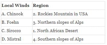
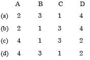
Match the following pairs:

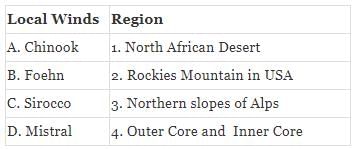
Select the correct answer using the code given below:

Detailed Solution for Test: Geography - 5 - Question 29

• Option (a) is correct: 

Local Winds
• Chinook wind: A warm, westerly wind found in western North America – Canada and the USA, when air from the Pacifi c blows over the Rocky Mountains and other upland areas.
• The Foehn is a warm, dry, gusty wind which occurs over the lower slopes on the lee side (the side which is not directly exposed to wind and weather) of a mountain barrier. It is a result of forcing stable air over a mountain barrier. The onset of a Foehn is generally sudden.  Foehn winds occur quite often in the Alps (where the name föhn originated) and in the Rockies (where the name chinook is used).
• The Sirocco: A hot, dry wind southerly wind which blows from the Sahara in northern Africa into the southern Mediterranean. It picks up moisture as it crosses the Mediterranean and can reach Spain, France, Italy and Greece bringing Saharan dust and hot, windy, damp weather, often with fog or low stratus cloud. In spring, the Sirocco can bring gale force winds. There are many local names for the Sirocco, including chom, arifi , Simoom, Ghibli, Chili, Khamsin, Solano, Leveche, Marin and Jugo.
• Mistral: Cold Northerly wind from Central France and the Alps to Mediterranean.

Test: Geography - 5 - Question 30

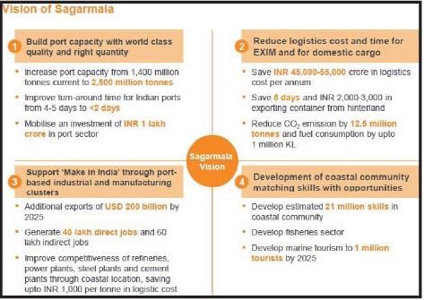
Consider the following statements with reference to vision of Sagarmala project:
1. To increase the turn-around time for India ports.
2. To promote port based industrial and manufacturing clusters.
3. Coastal Community Development through skill development and livelihood enhancement.
Which of the above statements is/are correct?

Detailed Solution for Test: Geography - 5 - Question 30

• Statement 1 is incorrect: It will improve the turn-around time for Indian ports from 4-5 days to <2 days.
Sagarmala Scheme:
• Sagar mala is project by Ministry of shipping to evolve a model of port led development which will transform India’s coastline as gateways of India’s prosperity.
• The concept of Sagar mala was first announced in 2003 by Atal Bihari Vajpayee . However it didn’t take off.
• The concept has been reintroduced in 2014 
• The initiative aims at integrating three things-the development of ports, industrial clusters and hinterland and efficient evacuation systems through road, rail, inland and coastal waterways.
• Sagarmala Coordination and Steering Committee (SCSC), including the Cabinet Secretary and the Secretaries of concerned departments, Chairman of Railway Board and CEO of NITI Aayog, shall ensure inter-ministerial coordination, and monitor the implementation of various projects under Sagarmala.

Information about Test: Geography - 5 Page
In this test you can find the Exam questions for Test: Geography - 5 solved & explained in the simplest way possible. Besides giving Questions and answers for Test: Geography - 5, EduRev gives you an ample number of Online tests for practice

Top Courses for UPSC

Download as PDF

Top Courses for UPSC