UPSC Exam  >  UPSC Tests  >  Test: Geography NCERT Based Test - 2 - UPSC MCQ

Test: Geography NCERT Based Test - 2 - UPSC MCQ


Test Description

25 Questions MCQ Test - Test: Geography NCERT Based Test - 2

Test: Geography NCERT Based Test - 2 for UPSC 2024 is part of UPSC preparation. The Test: Geography NCERT Based Test - 2 questions and answers have been prepared according to the UPSC exam syllabus.The Test: Geography NCERT Based Test - 2 MCQs are made for UPSC 2024 Exam. Find important definitions, questions, notes, meanings, examples, exercises, MCQs and online tests for Test: Geography NCERT Based Test - 2 below.
Solutions of Test: Geography NCERT Based Test - 2 questions in English are available as part of our course for UPSC & Test: Geography NCERT Based Test - 2 solutions in Hindi for UPSC course. Download more important topics, notes, lectures and mock test series for UPSC Exam by signing up for free. Attempt Test: Geography NCERT Based Test - 2 | 25 questions in 30 minutes | Mock test for UPSC preparation | Free important questions MCQ to study for UPSC Exam | Download free PDF with solutions
Test: Geography NCERT Based Test - 2 - Question 1

Which of the following factors are responsible for the variations in insolation at the surface of the Earth?
1. Revolution of the earth around the sun
2. Rotation of earth on its axis
3. The angle of inclination of the sun’s rays
4. Length of the day
5. Transparency of the atmosphere

Select the correct answer using the code given below:

Detailed Solution for Test: Geography NCERT Based Test - 2 - Question 1

Statement 1 is incorrect: Revolution of the Earth around the Sun is not responsible for the variations in insolation at the surface of the Earth.

Supplementary notes:

Variability of Insolation at the Surface of the Earth

  • The amount and the intensity of insolation vary during a day, in a season and in a year.
  • The factors that cause these variations in insolation are:
    (i) The rotation of the earth on its axis
    (ii) The angle of inclination of the sun’s rays
    (iii) The length of the day
    (iv) The transparency of the atmosphere
    (v) The configuration of land in terms of its aspect.
Test: Geography NCERT Based Test - 2 - Question 2

Trade Winds blows between

Detailed Solution for Test: Geography NCERT Based Test - 2 - Question 2

The areas of planetary winds are as follows:

  • Trade Winds: Sub-Tropical High to Equatorial Low
  • Westerlies: Sub-Tropical high to Sub-Polar Low
  • Polar Winds: Polar High to Sub-Pola Low
1 Crore+ students have signed up on EduRev. Have you? Download the App
Test: Geography NCERT Based Test - 2 - Question 3

Trees that are bent into unusual shapes as a result of being blown at an extreme angle by the wind, found largely along the upper edge of the tree line in Colorado Rocky Mountains and archipelago of Tierra del fuego are called?

Detailed Solution for Test: Geography NCERT Based Test - 2 - Question 3

Winds in Tierra del Fuego can reach well over 60mph (100kph), and result in the hardy species of trees that grow on the islands being bent into unusual shapes. These trees, which have been blown at an extreme angle by the wind, are often known as “flag trees” or “banner trees” because of the way they now stand.
Banner trees, also a regular feature of the Rocky Mountain, grow at treeline. They respond to the intense winds by growing branches only on the side of the trunk opposite the prevailing wind, thus taking advantage of the shelter provided by the trunk itself.

Test: Geography NCERT Based Test - 2 - Question 4

Consider the following statements:
1. Prime Meridian is a straight line passing through Greenwich.
2. International Date Line coincides with 180° longitude but deviates to make allowance for contiguous lands.

Which of the statements given above is/are correct?

Detailed Solution for Test: Geography NCERT Based Test - 2 - Question 4

International Date Line generally follows the 180 degree longitude. However, to avoid confusions and dividing a single country into two different calendar dates, it deviates at certain places, viz, Chukchi Peninsula, Kiribati and Samoa islands.

Test: Geography NCERT Based Test - 2 - Question 5

Which of the following is the largest volcanic region on the earth?

Detailed Solution for Test: Geography NCERT Based Test - 2 - Question 5

Scientists have uncovered the largest volcanic region on Earth – two kilometres below the surface of the vast ice sheet that covers west Antarctica.The project, by Edinburgh University researchers, has revealed almost 100 volcanoes. Geologists say this huge region is likely to dwarf that of east Africa’s volcanic ridge, currently rated the densest concentration of volcanoes in the world.

Test: Geography NCERT Based Test - 2 - Question 6

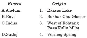
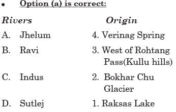
Consider the following pairs:

Which of the pairs given above is/are correctly matched?

Detailed Solution for Test: Geography NCERT Based Test - 2 - Question 6
  • Pair 2 is incorrectly matched: Dhauli Ganga and Vishnu Ganga: Joshi math
  • Pair 4 is incorrectly matched: Alaknanda and Pindar: Karnaprayag

Supplementary notes:

The Ganga System

  • The Ganga is the most important river of India both from the point of view of its basin and cultural significance. It rises in the Gangotri glacier near Gaumukh (3,900 m) in the Uttarkashi district of Uttarakhand.
  • Here, it is known as the Bhagirathi. It cuts through the Central and the Lesser Himalayas in narrow gorges. At Devprayag, the Bhagirathi meets the Alaknanda; hereafter, it is known as the Ganga.
  • The Alaknanda has its source in the Satopanth glacier above Badrinath. The Alaknanda consists of the Dhauli and the Vishnu Ganga which meet at Joshimath or Vishnu Prayag.
  • The other tributaries of Alaknanda such as the Pindar joins it at Karna Prayag while Mandakini or Kali Ganga meets it at Rudra Prayag. The Ganga enters the plains at Haridwar. From here, it flows first to the south, then to the south-east and east before splitting into two distributaries, namely the Bhagirathi and the Padma.
Test: Geography NCERT Based Test - 2 - Question 7

Consider  the following statements regarding the Inversion of Temperature:
1. A long winter night with clear skies and still air is ideal situation for inversion.
2. Over polar areas, a temperature inversion is normal throughout the year.

Which of the above statements is/are correct? 

Detailed Solution for Test: Geography NCERT Based Test - 2 - Question 7
  • Both statements are correct

Supplementary notes:

Inversion of Temperature

  • Normally, temperature decreases with an increase in elevation. It is called the normal lapse rate.
  • At times, the situations is reversed and the normal lapse rate is inverted. It is called Inversion of temperature.
  • Inversion is usually of short duration but quite common nonetheless. A long winter night with clear skies and still air is an ideal situation for inversion.
  • The heat of the day is radiated off during the night, and by early morning hours, the earth is cooler than the air above.
  • Over polar areas, a temperature inversion is normal throughout the year.
Test: Geography NCERT Based Test - 2 - Question 8

What is the impact of the cold oceanic currents in the tropical regions on the western margins of the continents?

Detailed Solution for Test: Geography NCERT Based Test - 2 - Question 8

The western margins of the continents in the tropical zone have a desert type of climate and the cold currents flowing along these tends to lower the temperature of the air thereby reducing its moisture absorption capacity. The flow of such dry cold air over the continental regions, though tends to lower the temperature, yet enhances aridity.

Test: Geography NCERT Based Test - 2 - Question 9

If the earth stops spinning gradually, which of the given options might become a possibility?

Detailed Solution for Test: Geography NCERT Based Test - 2 - Question 9

If Earth stopped spinning gradually, what it accomplishes in a single day might eventually take a year to complete; countries on the side facing the sun would experience daylight for 6 months, while those living on the side facing away from the sun would experience a six-month night. This is precisely what life is like at the North and South poles today at different points of the year.
Because the Earth rotates, centrifugal force causes the planet to bulge along the equator. No rotation, no bulge. Without that bulge, all of the extra water held in place along the equator would go rushing back toward the poles
Earth is comprised of three main layers — the core, the mantle and the crust. Since each layer is composed of different material, as the Earth’s rotation slows, each layer will slow at a different rate, creating massive friction between the layers. This friction would result in earthquakes where there had never been earthquakes before and enhanced volcanism, especially on the ocean floor. Once earth stopped spinning, the geological disturbances would decrease.
Currently, the rotation of Earth is faster than the moon, which results in the moon slowly moving away from Earth. If the rotation stops, the moon will start to move towards Earth, and it would eventually cause Earth to start rotating again. Unfortunately, the moon would continue to move closer to the Earth until it either collides with it or Earth’s gravity breaks the moon apart.

Test: Geography NCERT Based Test - 2 - Question 10

Consider the following statements regarding Erosional process:
1. It is controlled by the Kinetic Energy.  
2. Weathering is a pre-condition for erosion to take place.

Which of the above statements is/are correct?

Detailed Solution for Test: Geography NCERT Based Test - 2 - Question 10

Statement 2 is incorrect: Though weathering aids erosion it is not a precondition for erosion to take place.

Supplementary notes:

Erosion 

  • Erosion involves the acquisition and transportation of rock debris. When massive rocks break into smaller fragments through weathering and any other process, erosional geomorphic agents like running water, groundwater, glaciers, wind and waves remove and transport it to other places depending upon the dynamics of each of these agents.
  • Abrasion by rock debris carried by these geomorphic agents also aids greatly in erosion. By erosion, relief degrades, i.e., the landscape is worn down. That means, though weathering aids erosion it is not a pre-condition for erosion to take place.
  • Weathering, mass-wasting, and erosion are degradational processes.
  • It is erosion that is largely responsible for continuous changes that the earth’s surface is undergoing. 
  • Denudational processes like erosion and transportation are controlled by kinetic energy.
Test: Geography NCERT Based Test - 2 - Question 11

Chemical Weathering is most pronounced in

Detailed Solution for Test: Geography NCERT Based Test - 2 - Question 11

High Temperature and Water can cause much more pronounced and visible changes in any particular state of matter.

Test: Geography NCERT Based Test - 2 - Question 12

Consider the given statements with respect to ionosphere:
1) Ionosphere deflects long wavelength, medium wavelength and short wavelength radio waves and help in radio transmissions.
2) Ionosphere is the hottest region of the atmosphere

Which of the above given statements is/are not correct?

Detailed Solution for Test: Geography NCERT Based Test - 2 - Question 12

Thermosphere is the hottest region of the atmosphere

Test: Geography NCERT Based Test - 2 - Question 13

Consider the following statements regarding the dew formation in the atmosphere:
1. The ideal conditions for its formation are a clear sky, calm air, high relative humidity, and cold and long nights.
2. For the formation of dew, it is necessary that the dew point is below the freezing point.

Which of the above statements is/are correct? 

Detailed Solution for Test: Geography NCERT Based Test - 2 - Question 13
  • Statement 2 is incorrect: For the formation of dew, it is necessary that the dew point is above the freezing point.

Supplementary notes:

Dew

  • When the moisture is deposited in the form of water droplets on cooler surfaces of solid objects (rather than nuclei in the air above the surface) such as stones, grass blades, and plant leaves, it is known as dew.
  • The ideal conditions for its formation are a clear sky, calm air, high relative humidity, and cold and long nights.
  • For the formation of dew, it is necessary that the dew point is above the freezing point.
Test: Geography NCERT Based Test - 2 - Question 14

Consider the following statements and state which are correct?
1. The rate of temperature decrease in the atmosphere with increasing altitude is known as the lapse rate.
2. The amount of heat energy expended in changing the state or phase of a body, without raising its temperature is known as ‘latent heat’.

Detailed Solution for Test: Geography NCERT Based Test - 2 - Question 14

Normal Lapse rate is 6.5 Degree Celsius per Km of ascent.

Test: Geography NCERT Based Test - 2 - Question 15

What is the correct arrangement of the following mountain ranges from south to north?
1) Palkonda hills
2) Javadi hills
3) Nallamalai hills
4) Cardamom hills
5) Shevaroy hills

Choose the answer using the codes given below:

Detailed Solution for Test: Geography NCERT Based Test - 2 - Question 15

The correct option is A.
This is the correct arrangement of the mountain range from south to north.

Test: Geography NCERT Based Test - 2 - Question 16

“Cloud is a mass of minute water droplets or tiny crystals of ice formed by the condensation of the water vapour in free air at considerable elevations”. In this context, consider the following statements:
1. Cirrus clouds are always white in colour.
2. Cumulus clouds look like cotton wool and they have a circular base.
3. Nimbus clouds are black or dark gray in color.

Which of the above statements is/are correct? 

Detailed Solution for Test: Geography NCERT Based Test - 2 - Question 16
  • Statement 2 is incorrect: Cumulus clouds look like cotton wool and they have a fl at base.

Supplementary notes:

Clouds

  • Cloud is a mass of minute water droplets or tiny crystals of ice formed by the condensation
  • of the water vapour in free air at considerable elevations. As the clouds are formed at some height over the surface of the earth, they take various shapes.
  • According to their height, expanse, density and transparency or opaqueness clouds are grouped under four types:
    (i) cirrus
    (ii) cumulus
    (iii) stratus
    (iv) nimbus

Cirrus

  • Cirrus clouds are formed at high altitudes (8,000 - 12,000m). They are thin and detached clouds having a feathery appearance. They are always white in colour.

Cumulus

  • Cumulus clouds look like cotton wool. They are generally formed at a height of 4,000 - 7,000 m. They exist in patches and can be seen scattered here and there. They have a flat base.

Stratus

  • As their name implies, these are layered clouds covering large portions of the sky. These clouds are generally formed either due to loss of heat or the mixing of air masses with different temperatures.

Nimbus

  • Nimbus clouds are black or dark gray. They form at middle levels or very near to the surface of the earth. These are extremely dense and opaque to the rays of the sun. Sometimes, the clouds are so low that they seem to touch the ground. Nimbus clouds are shapeless masses of thick vapour.
Test: Geography NCERT Based Test - 2 - Question 17

Consider the given statements with respect to tornadoes:
1) For a vortex to be classifies as a tornado, the only precondition required is the contact of the violently rotating column of air with the clouds above.
2) In the US, warm moist winds from the Gulf of Mexico travel north and meet the cold dry winds from Canada, leading to the formation of tornadoes
3) The region lying between the Rocky and Appalachian mountains is called the Tornado Alley

Which of the above given statements is/are correct?

Detailed Solution for Test: Geography NCERT Based Test - 2 - Question 17

For a vortex to be classifies as a tornado, the precondition required is the contact of the violently rotating column of air with the clouds above and the ground below too.

Test: Geography NCERT Based Test - 2 - Question 18

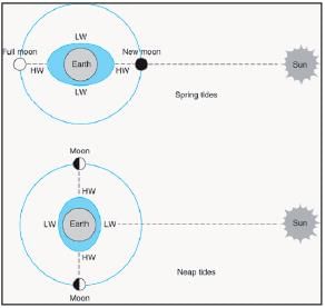
With reference to the Spring Tides, consider the following statements:
1. During these tides, the sun and the moon are at right angles.
2. They occur twice a month.

Which of the following statements is/are correct?

Detailed Solution for Test: Geography NCERT Based Test - 2 - Question 18

Statement 1 is incorrect. When the sun, the moon, and the earth are in a straight line, the height of the tide will be higher. These are called spring tides.

Supplementary notes:

Spring Tides

  • The position of both the sun and the moon in relation to the earth has a direct bearing on tide height.
  • When the sun, the moon, and the earth are in a straight line, the height of the tide will be higher.
  • These are called spring tides and they occur twice a month, one on full moon period and another during new moon period.
Test: Geography NCERT Based Test - 2 - Question 19

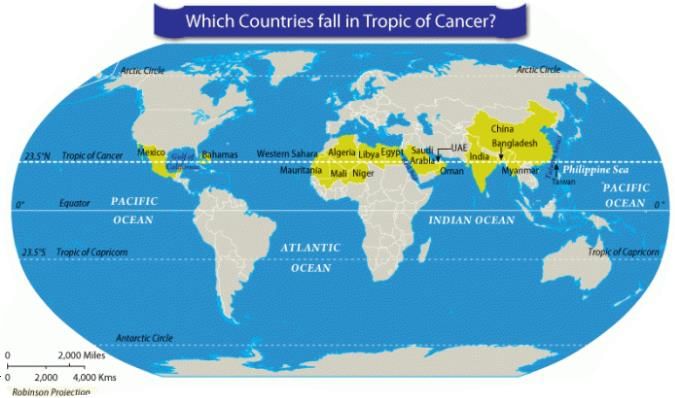
The tropic of cancer does not pass through which of the given countries?

Detailed Solution for Test: Geography NCERT Based Test - 2 - Question 19

Test: Geography NCERT Based Test - 2 - Question 20

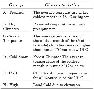
Consider the following statements regarding the characteristics of climatic groups according to Koeppen:
1. In dry climates potential evaporation exceeds precipitation.
2. In Tropical climate average temperature of the coldest month is 18° C or higher.

Which of the above statements is/are correct? 

Detailed Solution for Test: Geography NCERT Based Test - 2 - Question 20
  • Both statements are correct

Supplementary notes:

Koeppen’s Scheme of Classification of Climate

  • The most widely used classification of climate is the empirical climate classification scheme developed by V. Koeppen.
  • Koeppen identifieda close relationship between the distribution of vegetation and climate.
  • He selected certain values of temperature and precipitation and related them to the distribution of vegetation and used these values for classifying the climates.

Test: Geography NCERT Based Test - 2 - Question 21

The Jutland peninsula in Europe comprises of which of the following group of countries:

Detailed Solution for Test: Geography NCERT Based Test - 2 - Question 21

Jutland is a peninsula is in northern Europe. It forms the mainland part of Denmark and a northern part of Germany. It separates the North Sea from the Baltic Sea. Its terrain is relatively flat, with low hills and peat bogs.

Test: Geography NCERT Based Test - 2 - Question 22

Consider the following statements regarding Forest Cover and Forest Area:
1. The forest cover in the area notified and recorded as the forest land irrespective of the existence of trees, while the actual forest area is the area occupied by forests with canopy.
2. The forest area is based on the records of the State Revenue Department, while the forest cover is based on aerial photographs and satellite imageries.

Which of the above statements is/are incorrect?

Detailed Solution for Test: Geography NCERT Based Test - 2 - Question 22

Statement 1 is incorrect: The forest area is the area notified a recorded as the forest land irrespective of the existence of trees, while the actual forest cover is the area occupied by forests with canopy.

Supplementary notes:

Forest Cover

  • The forest area and the actual forest cover are not the same.
  • The forest area is the area notified and recorded as the forest land irrespective of the existence of trees, while the actual forest cover is the area occupied by forests with canopy.
  • The former is based on the records of the State Revenue Department, while the latter is based on aerial photographs and satellite imageries.
  • Both forest area and forest covers vary from state to state.
Test: Geography NCERT Based Test - 2 - Question 23

Which of the following statements is not correct?

Detailed Solution for Test: Geography NCERT Based Test - 2 - Question 23

A batholith is a large mass of intrusive igneous rock (also called plutonic rock) that forms from cooled magma deep in the Earth's crust and are thus not visible

Test: Geography NCERT Based Test - 2 - Question 24

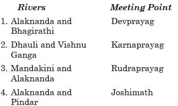
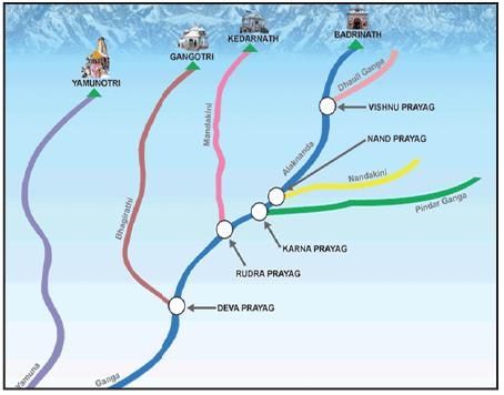
Match the following:

Select the correct answer using the code given below:

Detailed Solution for Test: Geography NCERT Based Test - 2 - Question 24

Supplementary notes:

Origin of Indus River System

  • The Indus also is known as the Sindhu, is the westernmost of the Himalayan rivers in India. It originates from a glacier near Bokhar Chu (31°15’ N latitude and 81°40’ E longitude) in the Tibetan region at an altitude of 4,164 m in the Kailash Mountain range.
  • The Jhelum, an important tributary of the Indus, rises from a spring at Verinag situated at the foot of the Pir Panjal in the south-eastern part of the valley of Kashmir.
  • It flows through Srinagar and the Wular lake before entering Pakistan through a deep narrow gorge. It joins the Chenab near Jhang in Pakistan.
  • The Ravi is another important tributary of the Indus. It rises west of the Rohtang pass in the Kullu hills of Himachal Pradesh and flows through the Chamba valley of the state. Before entering Pakistan and joining the Chenab near Sarai Sidhu, it drains the area lying between the southeastern part of the Pir Panjal and the Dhauladhar ranges.
  • The Satluj originates in the ‘Raksas tal’ near Mansarovar at an altitude of 4,555 m in Tibet where it is known as Langchen Khambab. It flows almost parallel to the Indus for about 400 km before entering India and comes out of a gorge at Rupar. It passes through the Shipki La on the Himalayan ranges and enters the Punjab plains. 
Test: Geography NCERT Based Test - 2 - Question 25

Consider the following statements in context of Baltic Sea:
1) The youngest sea on the planet, emerging from the retiring ice masses, the Baltic Sea drains into the North Sea
2) The composition of Baltic Sea includes both salt and fresh water, which in turn has given rise to a sensitive, unique and an interdependent marine ecosystem
3) The term Nordic, Baltic and Scandinavian are used interchangeably for the same group of states across the Baltic Sea

Which of the above given statements is/are correct?

Detailed Solution for Test: Geography NCERT Based Test - 2 - Question 25

While the term Scandinavia is commonly used for Denmark, Norway and Sweden, the term the Nordic countries is used unambiguously for Denmark, Norway, Sweden, Finland, and Iceland, including their associated territories (Greenland, the Faroe Islands, and the Åland Islands). Scandinavia can thus be considered a subset of the Nordic countries.
The Baltic States are the three countries in northern Europe on the eastern coast of the Baltic Sea: Estonia, Latvia and Lithuania

Information about Test: Geography NCERT Based Test - 2 Page
In this test you can find the Exam questions for Test: Geography NCERT Based Test - 2 solved & explained in the simplest way possible. Besides giving Questions and answers for Test: Geography NCERT Based Test - 2, EduRev gives you an ample number of Online tests for practice

Top Courses for UPSC

Download as PDF

Top Courses for UPSC