Class 8 Exam  >  Class 8 Tests  >  Online MCQ Tests for Class 8  >  Test: Land Soil Water Natural And Wildlife Resources- 4 - Class 8 MCQ

Test: Land Soil Water Natural And Wildlife Resources- 4 - Class 8 MCQ


Test Description

20 Questions MCQ Test Online MCQ Tests for Class 8 - Test: Land Soil Water Natural And Wildlife Resources- 4

Test: Land Soil Water Natural And Wildlife Resources- 4 for Class 8 2024 is part of Online MCQ Tests for Class 8 preparation. The Test: Land Soil Water Natural And Wildlife Resources- 4 questions and answers have been prepared according to the Class 8 exam syllabus.The Test: Land Soil Water Natural And Wildlife Resources- 4 MCQs are made for Class 8 2024 Exam. Find important definitions, questions, notes, meanings, examples, exercises, MCQs and online tests for Test: Land Soil Water Natural And Wildlife Resources- 4 below.
Solutions of Test: Land Soil Water Natural And Wildlife Resources- 4 questions in English are available as part of our Online MCQ Tests for Class 8 for Class 8 & Test: Land Soil Water Natural And Wildlife Resources- 4 solutions in Hindi for Online MCQ Tests for Class 8 course. Download more important topics, notes, lectures and mock test series for Class 8 Exam by signing up for free. Attempt Test: Land Soil Water Natural And Wildlife Resources- 4 | 20 questions in 20 minutes | Mock test for Class 8 preparation | Free important questions MCQ to study Online MCQ Tests for Class 8 for Class 8 Exam | Download free PDF with solutions
Test: Land Soil Water Natural And Wildlife Resources- 4 - Question 1

Terracing is an effective method of soil conservation in_____________.

Detailed Solution for Test: Land Soil Water Natural And Wildlife Resources- 4 - Question 1
On hilly slopes, terraces act as bunds and prevent the soil from being washed away by running water.

Test: Land Soil Water Natural And Wildlife Resources- 4 - Question 2

Soil conservation means_________.

Detailed Solution for Test: Land Soil Water Natural And Wildlife Resources- 4 - Question 2

Soil conservation protects soil from erosion and other deterioration types to maintain soil fertility and productivity. It generally includes watershed management and water use.

1 Crore+ students have signed up on EduRev. Have you? Download the App
Test: Land Soil Water Natural And Wildlife Resources- 4 - Question 3

In Tamil Nadu soil erosion by___________is very common in Kambam valley.

Detailed Solution for Test: Land Soil Water Natural And Wildlife Resources- 4 - Question 3
Soil erosion meremovingl of the top layer of the soil, which makes the soil infertile.

Test: Land Soil Water Natural And Wildlife Resources- 4 - Question 4

Planting of trees on a large scale to check soil erosion is known as__________.

Detailed Solution for Test: Land Soil Water Natural And Wildlife Resources- 4 - Question 4
Reforestation is the natural or intentional restocking of existing forests and woodlands that have been depleted, usually through deforestation. Reforestation activities promote the gradual depletion of CO2 from the atmosphere through absorption during photosynthesis.

Test: Land Soil Water Natural And Wildlife Resources- 4 - Question 5

Mulching is associated with use of________________.

Detailed Solution for Test: Land Soil Water Natural And Wildlife Resources- 4 - Question 5
A mulch is a layer of material applied to the surface of an area of soil. It’s used for the following purposes: 1. to conserve moisture. 2. to improve the fertility of earthsoil. 3. to reduce weed growth.

Test: Land Soil Water Natural And Wildlife Resources- 4 - Question 6

Where does approximately 69% fresh water on the earth occur?

Detailed Solution for Test: Land Soil Water Natural And Wildlife Resources- 4 - Question 6
70 per cent of freshwater occurs as ice sheets and glaciers in Antarctica, Greenland and the mountainous regions of the world, while a little less than 30 per cent is stored as groundwater in the world’s aquifers and only close to 1% as surface water in rivers, lakes, etc.

Test: Land Soil Water Natural And Wildlife Resources- 4 - Question 7

In India which irrigation sources have the maximum area?

Detailed Solution for Test: Land Soil Water Natural And Wildlife Resources- 4 - Question 7
Sources of irrigation in India includes a network of major and minor canals from Indian rivers, groundwater well-based systems, tanks, and other rainwater harvesting projects for agricultural activities. Irrigation in India helps improve food security, reduce dependence on monsoons, improve agricultural productivity and create rural job opportunities. India’s total area under irrigation is 64.7 million hectares. Of this maximum 45% is shared by tube wells followed by Canals and wells. So, in India wells and tubewells has the maximum area.

Test: Land Soil Water Natural And Wildlife Resources- 4 - Question 8

Soil erosion is prevalent in__________.

Detailed Solution for Test: Land Soil Water Natural And Wildlife Resources- 4 - Question 8
Most common is when rivers or streams overflow their banks. Excessive rain, a ruptured dam or levee, rapid ice melting in the mountains, or even an, unfortunately, placed beaver dam can overwhelm a river and send it spreading over the adjacent land.

Test: Land Soil Water Natural And Wildlife Resources- 4 - Question 9

It is important to make small check dams across the flooded bullies because they-

(i) hold water for irrigation.

(ii) hold water and prevent soil erosion.

(iii) recharge groundwater.

(iv) hold water permanently. Select the correct options from the above-stated reasons-

Detailed Solution for Test: Land Soil Water Natural And Wildlife Resources- 4 - Question 9
A check dam is a small, often temporary, dam constructed across a swale, drainage ditch, or waterway to counteract erosion by reducing water flow velocity.

Test: Land Soil Water Natural And Wildlife Resources- 4 - Question 10

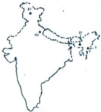
Match the freshwater lake on the map of India (I, II, III, IV) with their respective names.

A. Bhimtal

B.Loktak

C. Barapani

D. Dal Lake

Detailed Solution for Test: Land Soil Water Natural And Wildlife Resources- 4 - Question 10
In the given map following are the freshwater lakes depicted

1) Bhimtal Lake is in Uttarakhand

2) Loktak Lake is in Manipur

3) Barapani Lake is in Meghalaya

4) Dal Lake is in Jammu and Kashmir

Test: Land Soil Water Natural And Wildlife Resources- 4 - Question 11

Which one of the following types of erosion is responsible for the formation of Chambal Ravines?

Detailed Solution for Test: Land Soil Water Natural And Wildlife Resources- 4 - Question 11
Gully erosion is responsible for the formation of Chambal Ravines. Ravines are a type of fluvial erosional feature and are formed as a result of constant vertical erosion by streams and rivers flowing over semi-arid and arid regions.

Test: Land Soil Water Natural And Wildlife Resources- 4 - Question 12

In which of the following ways can soil be conserved?

1. Contour Ploughing

2. Terracing

3. Shifting cultivation

4. Crop rotation

Detailed Solution for Test: Land Soil Water Natural And Wildlife Resources- 4 - Question 12
Techniques for improved soil conservation include crop rotation, cover crops, conservation tillage and planted windbreaks, affect both erosion and fertility. When plants die, they decay and become part of the soil. Code 330 defines standard methods recommended by the U.S. Natural Resources Conservation Service.

Test: Land Soil Water Natural And Wildlife Resources- 4 - Question 13

Soil can be conserved in a best on the hills by which of the cultivation methods?

Detailed Solution for Test: Land Soil Water Natural And Wildlife Resources- 4 - Question 13
Ploughing along the contour lines can decelerate the flow of water down the slopes. This is called contour ploughing. This is the best method to reduce soil erosion in hilly areas.

Test: Land Soil Water Natural And Wildlife Resources- 4 - Question 14

Which one of the following is the main cause of land degradation in Punjab?

Detailed Solution for Test: Land Soil Water Natural And Wildlife Resources- 4 - Question 14
Over irrigation is the main cause of land degradation in Punjab due to waterlogging leading to an increase in salinity and alkalinity in the soil. Punjab, Haryana, Uttar Pradesh are the states facing the issue of land degradation.

Test: Land Soil Water Natural And Wildlife Resources- 4 - Question 15

The removal of top soil by water or wind is called___________.

Detailed Solution for Test: Land Soil Water Natural And Wildlife Resources- 4 - Question 15
Soil erosion is the displacement of the upper layer of soil; it is a form of soil degradation. This natural process is caused by the dynamic activity of erosive agents, that is, water, ice, snow, air, plants, animals, and humans.

Test: Land Soil Water Natural And Wildlife Resources- 4 - Question 16

Which one of the following is not a biosphere reserve?

Detailed Solution for Test: Land Soil Water Natural And Wildlife Resources- 4 - Question 16
A biosphere reserve is an ecosystem with plants and animals of unusual scientific and natural interest. It is a label given by UNESCO. India has 18 biosphere reserves From the given options, Kaziranga national park located in Assam is not a biosphere reserve.

Test: Land Soil Water Natural And Wildlife Resources- 4 - Question 17

The phenomenon of the erosion of the highlands is called_______________.

Detailed Solution for Test: Land Soil Water Natural And Wildlife Resources- 4 - Question 17
In highlands, the erosion is mainly natural or due to human-induced process that negatively affects the land. This comes under land degradation. The human-induced process includes deforestation, clearing fertile land for settlements, slashing, burning the trees for agriculture, surface mining, and many others. Natural process which leads to land degradation is recurrent droughts and climate change.

Test: Land Soil Water Natural And Wildlife Resources- 4 - Question 18

In which of the following continents is Tanzania situated?

Detailed Solution for Test: Land Soil Water Natural And Wildlife Resources- 4 - Question 18
Map showing where is Tanzania located in the World. The given Tanzania location map shows that Tanzania is located in the central-east part of Africa continent.

Test: Land Soil Water Natural And Wildlife Resources- 4 - Question 19

Which of the following is the most important natural resource?

Detailed Solution for Test: Land Soil Water Natural And Wildlife Resources- 4 - Question 19
All are important natural resources because

1. Air is very important without air we cannot survive

2. Water is also very important without water no plants are grown and also our body may not get minerals

3. Land is also important because we cultivate and live on land if land does not exist we might not be here now.

Test: Land Soil Water Natural And Wildlife Resources- 4 - Question 20

The uneven distribution of population in the world is due to the varied characteristics of

Detailed Solution for Test: Land Soil Water Natural And Wildlife Resources- 4 - Question 20
The uneven distribution of the population in different parts of the world is mainly due to varied characteristics of land and climate. Because in every region the climate, topography and other factors are different.
210 tests
Information about Test: Land Soil Water Natural And Wildlife Resources- 4 Page
In this test you can find the Exam questions for Test: Land Soil Water Natural And Wildlife Resources- 4 solved & explained in the simplest way possible. Besides giving Questions and answers for Test: Land Soil Water Natural And Wildlife Resources- 4, EduRev gives you an ample number of Online tests for practice

Top Courses for Class 8

Download as PDF

Top Courses for Class 8