UPSC Exam  >  UPSC Tests  >  भूगोल (Geography) for UPSC CSE in Hindi  >  टेस्ट: पर्वत चोटियाँ और पर्वतमाला - UPSC MCQ

टेस्ट: पर्वत चोटियाँ और पर्वतमाला - UPSC MCQ


Test Description

25 Questions MCQ Test भूगोल (Geography) for UPSC CSE in Hindi - टेस्ट: पर्वत चोटियाँ और पर्वतमाला

टेस्ट: पर्वत चोटियाँ और पर्वतमाला for UPSC 2024 is part of भूगोल (Geography) for UPSC CSE in Hindi preparation. The टेस्ट: पर्वत चोटियाँ और पर्वतमाला questions and answers have been prepared according to the UPSC exam syllabus.The टेस्ट: पर्वत चोटियाँ और पर्वतमाला MCQs are made for UPSC 2024 Exam. Find important definitions, questions, notes, meanings, examples, exercises, MCQs and online tests for टेस्ट: पर्वत चोटियाँ और पर्वतमाला below.
Solutions of टेस्ट: पर्वत चोटियाँ और पर्वतमाला questions in English are available as part of our भूगोल (Geography) for UPSC CSE in Hindi for UPSC & टेस्ट: पर्वत चोटियाँ और पर्वतमाला solutions in Hindi for भूगोल (Geography) for UPSC CSE in Hindi course. Download more important topics, notes, lectures and mock test series for UPSC Exam by signing up for free. Attempt टेस्ट: पर्वत चोटियाँ और पर्वतमाला | 25 questions in 35 minutes | Mock test for UPSC preparation | Free important questions MCQ to study भूगोल (Geography) for UPSC CSE in Hindi for UPSC Exam | Download free PDF with solutions
टेस्ट: पर्वत चोटियाँ और पर्वतमाला - Question 1

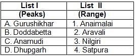
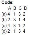
निम्नलिखित को मिलाएं

Detailed Solution for टेस्ट: पर्वत चोटियाँ और पर्वतमाला - Question 1

गुरु शिखर, राजस्थान के अरबुडा पर्वत की एक चोटी है, जो अरावली पर्वतमाला का सबसे ऊँचा स्थान है। यह 1,722 मीटर की ऊंचाई तक बढ़ जाता है।

डोड्डाबेट्टा नीलगिरि पहाड़ियों में 2,637 मीटर की ऊँचाई पर स्थित है। शिखर के चारों ओर एक आरक्षित वन क्षेत्र है। यह भारत के तमिलनाडु के नीलगिरी जिले में ऊटी-कोटागिरी रोड पर ऊटी से 9 किमी दूर है।

अनामुडी या अनाईमुडी भारतीय राज्य केरल में स्थित एक पर्वत है। यह 2,695 मीटर की ऊंचाई पर, और 2,479 मीटर की स्थलाकृतिक ऊंचाई पर, पश्चिमी घाट और दक्षिण भारत की सबसे ऊंची चोटी है।

सतपुड़ा रेंज और मध्य प्रदेश, भारत में धुपगढ़ या धुपगढ़ सबसे ऊँचा स्थान है। पचमढ़ी में स्थित, इसकी ऊंचाई 1,350 मीटर है।

Guru Shikhar, a peak in the Arbuda Mountains of Rajasthan, is the highest point of the Aravalli range. It rises to a height of 1,722 meters.

Doddabetta is situated at an altitude of 2,637 meters in the Nilgiri Hills. There is a reserve forest area around the summit. It is 9 km from Ooty on the Ooty-Kotagiri road in the Nilgiris district of Tamil Nadu, India.

Anamudi or Anaimudi is a mountain located in the Indian state of Kerala. It is the highest peak in the Western Ghats and South India, at an altitude of 2,695 metres, and a topographical elevation of 2,479 metres.

Dhupgarh or Dhupgarh is the highest point in the Satpura range and Madhya Pradesh, India. Situated in Pachmarhi, it has an altitude of 1,350 meters.

टेस्ट: पर्वत चोटियाँ और पर्वतमाला - Question 2

डोड्डाबेट्टा पीक में स्थित है

Doddabetta Peak is located in

Detailed Solution for टेस्ट: पर्वत चोटियाँ और पर्वतमाला - Question 2

नीलगिरि हिल्स दक्षिण भारत में कर्नाटक और केरल राज्यों के जंक्शन पर तमिलनाडु राज्य के पश्चिमी भाग में 2,000 मीटर (6,600 फीट) से कम से कम 24 चोटियों वाले पहाड़ों की एक श्रृंखला है। वे बड़े पश्चिमी घाट पर्वत श्रृंखला का हिस्सा हैं जो दक्खन के पठार के दक्षिण-पश्चिमी छोर को बनाते हैं।

The Nilgiri Hills are a chain of mountains with at least 24 peaks above 2,000 m (6,600 ft) in the western part of the state of Tamil Nadu at the junction of the states of Karnataka and Kerala in southern India. They are part of the larger Western Ghats mountain range that forms the south-western edge of the Deccan Plateau.

1 Crore+ students have signed up on EduRev. Have you? Download the App
टेस्ट: पर्वत चोटियाँ और पर्वतमाला - Question 3

रमन शिखर में स्थित है

Raman peak is located in

Detailed Solution for टेस्ट: पर्वत चोटियाँ और पर्वतमाला - Question 3

रमन चोटी अरब सागर में स्थित एक पनडुब्बी पर्वत शिखर को दिया गया नाम है।

Raman Peak is the name given to a submarine mountain peak located in the Arabian Sea.

टेस्ट: पर्वत चोटियाँ और पर्वतमाला - Question 4

दक्षिण भारत की सबसे ऊँची चोटी है

The highest peak in South India is

Community-verified icon

Detailed Solution for टेस्ट: पर्वत चोटियाँ और पर्वतमाला - Question 4

अनामुडी दक्षिण भारत की सबसे ऊँची चोटी है। यह 2695 मीटर की ऊंचाई पर स्थित है और केरल में स्थित है।

Anamudi is the highest peak in South India. It is situated at an altitude of 2695 meters and is situated in Kerala.

टेस्ट: पर्वत चोटियाँ और पर्वतमाला - Question 5

निम्नलिखित में से कौन सी चोटियां सबसे ऊंची हैं?

Which of the following peaks is the highest?

Detailed Solution for टेस्ट: पर्वत चोटियाँ और पर्वतमाला - Question 5

गॉडविन ऑस्टेन (K2) दिए गए विकल्पों में सबसे ऊँची चोटी है। यह दुनिया की दूसरी सबसे ऊंची चोटी है। यह उत्तरी कश्मीर में हिमालय के काराकोरम रेंज में स्थित है। इसकी ऊंचाई 8611 मी है।

Godwin Austen (K2) is the highest peak among the given options. It is the second highest peak in the world. It is located in the Karakoram range of the Himalayas in northern Kashmir. Its height is 8611 m.

टेस्ट: पर्वत चोटियाँ और पर्वतमाला - Question 6

भारत में पहाड़ों के स्थानों को ध्यान में रखते हुए, निम्न में से कौन दक्षिण से उत्तर की ओर सही क्रम में है?

Considering the locations of mountains in India, which of the following is in the correct order from south to north?

Detailed Solution for टेस्ट: पर्वत चोटियाँ और पर्वतमाला - Question 6

डोड्डाबेट्टा नीलगिरि पहाड़ियों (तमिलनाडु) में 2,637 मीटर की ऊँचाई पर स्थित है। विंध्य मध्य भारत के अधिकांश हिस्सों में चलता है। नेपाल में धौलागिरि का द्रव्यमान कालीगंडकी नदी के पश्चिम से भेरी तक 120 किलोमीटर तक फैला हुआ है। माउंट कैलाश शिखर हिमालय पर्वत में तिब्बत के सुदूर दक्षिण-पश्चिम कोने में खड़ा है।

Doddabetta is situated at an altitude of 2,637 meters in the Nilgiri Hills (Tamil Nadu). The Vindhyas run through most of central India. The Dhaulagiri massif in Nepal extends 120 km west of the Kaligandaki River to Bheri. Mount Kailash peak stands in the Himalayan Mountains in the far south-west corner of Tibet.

टेस्ट: पर्वत चोटियाँ और पर्वतमाला - Question 7

उत्तर से दक्षिण क्रम तक निम्न पर्वत श्रृंखलाओं की व्यवस्था करें

और कोड से सही उत्तर चुनें:

(i) धौलाधार

(ii) लद्दाख

(iii) पीरपंजाल

(iv) ज़स्कर

कोड:

Arrange the following mountain ranges in order from north to south

and choose the correct answer from the code :

(i) Dhauladhar

(ii) Ladakh

(iii) Pir Panjal

(iv) Zaskar

Code:

Detailed Solution for टेस्ट: पर्वत चोटियाँ और पर्वतमाला - Question 7

उत्तर से दक्षिण तक

Ladakh -> Zaskar ->Pirpanjal ->Dhauladhar

टेस्ट: पर्वत चोटियाँ और पर्वतमाला - Question 8

निम्नलिखित में से कौन सा कथन हिमालय के संबंध में सही नहीं है?

Which one of the following statements is not correct with respect to the Himalayas?

Detailed Solution for टेस्ट: पर्वत चोटियाँ और पर्वतमाला - Question 8

हिमालय समानांतर पर्वत श्रृंखलाओं से मिलकर बना है: दक्षिण में शिवालिक पहाड़ियाँ; निचली हिमालय श्रेणी; महान हिमालय, जो उच्चतम और केंद्रीय श्रेणी है; और उत्तर में तिब्बती हिमालय। काराकोरम को आमतौर पर हिमालय से अलग माना जाता है।

The Himalayas consist of parallel mountain ranges: the Shivalik Hills in the south; lower Himalayan range; The Great Himalaya, which is the highest and central range; and the Tibetan Himalayas to the north. The Karakoram is generally considered to be separate from the Himalayas.

टेस्ट: पर्वत चोटियाँ और पर्वतमाला - Question 9

निम्नलिखित में से कौन सी पर्वत श्रृंखला भारत में केवल एक राज्य में फैली हुई है?

Which of the following mountain ranges extends over only one state in India?

Detailed Solution for टेस्ट: पर्वत चोटियाँ और पर्वतमाला - Question 9

अजंता पर्वत श्रृंखला भारत में केवल एक राज्य यानी महाराष्ट्र में फैली हुई है।

The Ajanta mountain range is spread over only one state in India i.e. Maharashtra.

टेस्ट: पर्वत चोटियाँ और पर्वतमाला - Question 10

निम्नलिखित में से कौन भारत की सबसे पुरानी पर्वत श्रृंखला है?

Which of the following is the oldest mountain range in India?

Detailed Solution for टेस्ट: पर्वत चोटियाँ और पर्वतमाला - Question 10

अरावली रेंज भारत में पहाड़ों की सबसे पुरानी तह है।

The Aravalli range is the oldest fold of mountains in India.

टेस्ट: पर्वत चोटियाँ और पर्वतमाला - Question 11

निम्नलिखित में से कौन सा कथन सही है?

Which of the following statement is correct?

Detailed Solution for टेस्ट: पर्वत चोटियाँ और पर्वतमाला - Question 11

जब समुद्र संकुचित हो गया तब हिमालय टेथिस सागर से उठा।

The Himalayas rose from the Tethys Sea when the sea contracted.

टेस्ट: पर्वत चोटियाँ और पर्वतमाला - Question 12

हिमालय के तलहटी क्षेत्र को क्या नाम दिया गया है?

What is the name given to the foothills of the Himalayas?

टेस्ट: पर्वत चोटियाँ और पर्वतमाला - Question 13

माउंट एवरेस्ट ___ क्षेत्र में स्थित है

Mount Everest is located in the region of

Detailed Solution for टेस्ट: पर्वत चोटियाँ और पर्वतमाला - Question 13

द माउंट। एवरेस्ट नेपाल हिमालय के क्षेत्र में स्थित है

The Mt. Everest Nepal is located in the region of Himalayas

टेस्ट: पर्वत चोटियाँ और पर्वतमाला - Question 14

सूची- II के साथ सूची- I का मिलान करें और इनमें से सही उत्तर चुनें

नीचे दिए गए कोड:

Detailed Solution for टेस्ट: पर्वत चोटियाँ और पर्वतमाला - Question 14

शिपकी ला भारत-चीन सीमा पर एक पहाड़ी दर्रा और सीमा चौकी है। यह भारत के हिमाचल प्रदेश राज्य में किन्नौर जिले में स्थित है। नीती पास उत्तराखंड में है, नाथूला पास सिक्किम में है और बोमडी ला अरुणाचल प्रदेश में है।

Shipki La is a mountain pass and border post on the India-China border. It is located in Kinnaur district in the state of Himachal Pradesh, India. Niti Pass is in Uttarakhand, Nathula Pass is in Sikkim and Bomdi La is in Arunachal Pradesh.

टेस्ट: पर्वत चोटियाँ और पर्वतमाला - Question 15

किंग्री-विंग्री, नीति माणा क्या है?

What is Kingry-Wingry, Niti Mana?

Detailed Solution for टेस्ट: पर्वत चोटियाँ और पर्वतमाला - Question 15

किंग्री-विंग्री, नीति माणा दर्रे (Passes) हैं। नीति दर्रा भारत के उत्तराखंड राज्य को तिब्बत से जोड़ने वाला हिमालय का एक प्रमुख दर्रा हैं। माणा या माना दर्रा हिमालय क्षेत्र में भारत और तिब्बत के बीच स्थित है। जिसे चिरिबितिया या डूंगरी ला भी कहा जाता है। इसी दर्रे में देवताल झील है, जहां से अलकनंदा की सहायिका नदी, सरस्वती का उद्गम होता है।

Kingri-Wingri, Niti Mana are Passes. Niti Pass is a major pass in the Himalayas connecting the Indian state of Uttarakhand with Tibet. Mana or Mana Pass is located in the Himalayan region between India and Tibet. Also known as Chiribitiya or Dungri La. In this pass is the Devtal lake, from where the river Saraswati, the tributary of the Alaknanda, 

टेस्ट: पर्वत चोटियाँ और पर्वतमाला - Question 16

अरुणाचल प्रदेश में निम्नलिखित में से कौन सा दर्रा है?

Which of the following pass is in Arunachal Pradesh?

Detailed Solution for टेस्ट: पर्वत चोटियाँ और पर्वतमाला - Question 16

बामडिला दर्रा अरुणाचल प्रदेश में है।

Bamdila Pass is in Arunachal Pradesh.

टेस्ट: पर्वत चोटियाँ और पर्वतमाला - Question 17

निम्नलिखित में से कौन सी पर्वत श्रृंखला भारत में सबसे पुरानी है?

Which of the following mountain range is the oldest in India?

Detailed Solution for टेस्ट: पर्वत चोटियाँ और पर्वतमाला - Question 17

अरावली पर्वत श्रृंखला भारत की सबसे पुरानी पर्वत श्रृंखला है।

The Aravalli mountain range is the oldest mountain range in India.

टेस्ट: पर्वत चोटियाँ और पर्वतमाला - Question 18

बिहार राज्य के उत्तर-पश्चिमी भागों में निम्नलिखित में से कौन से भू-भाग पर कब्जा है?

Which of the following landmass is occupied in the north-western parts of the state of Bihar?

Detailed Solution for टेस्ट: पर्वत चोटियाँ और पर्वतमाला - Question 18

सोमेश्वर पहाड़ी रेंज बिहार राज्य के उत्तर-पश्चिमी भाग में स्थित है।

The Someshwar hill range is located in the north-western part of the state of Bihar.

टेस्ट: पर्वत चोटियाँ और पर्वतमाला - Question 19

नाथू ला दर्रा के बारे में निम्नलिखित में से कौन सा कथन सही है?

(i) यह सिक्किम को तिब्बत से जोड़ता है

(ii) यह प्राचीन रेशम मार्ग की मुख्य धमनी थी

(iii) इसे वर्ष 2006 में फिर से खोला गया

नीचे दिए गए कोड का उपयोग करके सही उत्तर चुनें:

Which of the following statements about Nathu La Pass is correct?

(i) It connects Sikkim with Tibet

(ii) It was the main artery of the ancient Silk Road

(iii) It was reopened in the year 2006

Select the correct answer using the codes given below :

Detailed Solution for टेस्ट: पर्वत चोटियाँ और पर्वतमाला - Question 19

नाथू ला हिमालय में एक पहाड़ी दर्रा है। यह भारतीय राज्य सिक्किम को चीन के तिब्बत स्वायत्त क्षेत्र से जोड़ता है। पास समुद्र तल से 4,310 मीटर (14,140 फीट) की दूरी पर, प्राचीन सिल्क रोड के एक हिस्से का हिस्सा है।

नाथुमिन "सुनने वाले कान" और ला का मतलब तिब्बती में "पास" है। सिक्किम की राजधानी गंगटोक से पूर्व की ओर भारतीय मार्ग 54 किमी (34 मील) दूर है। केवल भारत के नागरिक ही गंगटोक में परमिट प्राप्त करने के बाद पास की यात्रा कर सकते हैं।

Nathu La is a mountain pass in the Himalayas. It connects the Indian state of Sikkim with the Tibet Autonomous Region of China. The pass is part of a section of the ancient Silk Road, at 4,310 meters (14,140 ft) above sea level.

Nathumin means "hearing ear" and la means "near" in Tibetan. The Indian route is 54 km (34 mi) to the east from Gangtok, the capital of Sikkim. Only citizens of India can travel with the pass after obtaining a permit in Gangtok.

टेस्ट: पर्वत चोटियाँ और पर्वतमाला - Question 20

निम्नलिखित को मिलाएं

Detailed Solution for टेस्ट: पर्वत चोटियाँ और पर्वतमाला - Question 20

ज़ोजी ला जम्मू और कश्मीर, भारत में एक उच्च पर्वतीय दर्रा है, जो हिमालय पर्वत श्रृंखला के पश्चिमी भाग में श्रीनगर और लेह के बीच भारतीय राष्ट्रीय राजमार्ग 1D पर स्थित है।

बारा-लाचा ला जिसे बारा-लाचा दर्रा या बरलाचा ला के नाम से भी जाना जाता है, ज़ांस्कर रेंज में एक उच्च पर्वतीय दर्रा है, जो हिमाचल प्रदेश में लाहौल जिले को जम्मू और कश्मीर में लद्दाख से जोड़ता है, जो लेह - मनाली राजमार्ग के साथ स्थित है।

जेलेप ला या जेलेप पास, ऊँचाई 4,267 मीटर या 13,999 फीट, पूर्वी सिक्किम जिला, सिक्किम, भारत और

तिब्बत स्वायत्त क्षेत्र, चीन। यह एक ऐसे मार्ग पर है जो ल्हासा को भारत से जोड़ता है। पास की लंबाई 46 मीटर है। जोशीमठ की नीती घाटी में एक छोटा सा गाँव है नीती। निति चमोली जिले की भारत - तिब्बत सीमा में अंतिम गाँव और चौकी है।

Zoji La is a high mountain pass in Jammu and Kashmir, India, located on the Indian National Highway 1D between Srinagar and Leh in the western part of the Himalayan mountain range.

Bara-Lacha La also known as Bara-Lacha Pass or Barlacha La, is a high mountain pass in the Zanskar Range, which connects Lahaul district in Himachal Pradesh to Ladakh in Jammu and Kashmir, on the Leh - Manali Highway. is located with.

Jelep La or Jelep Pass, altitude 4,267 m or 13,999 ft, East Sikkim District, Sikkim, India और तिब्बत स्वायत्त क्षेत्र, चीन। यह एक ऐसे मार्ग पर है जो ल्हासा को भारत से जोड़ता है। पास की लंबाई 46 मीटर है। जोशीमठ की नीती घाटी में एक छोटा सा गाँव है नीती। निति चमोली जिले की भारत - तिब्बत सीमा में अंतिम गाँव और चौकी है।

टेस्ट: पर्वत चोटियाँ और पर्वतमाला - Question 21

हिमालय में पीरपंजाल श्रेणी इसका एक हिस्सा है:

The Pir Panjal range in the Himalayas is a part of:

Detailed Solution for टेस्ट: पर्वत चोटियाँ और पर्वतमाला - Question 21

पीरपंजाल रेंज का संबंध कम हिमालयी क्षेत्र से है। इसमें हिमाचल प्रदेश, जम्मू और कश्मीर और कश्मीर (POK) शामिल हैं।

The Pir Panjal range belongs to the Lesser Himalayan region. This includes Himachal Pradesh, Jammu and Kashmir and Kashmir (POK).

टेस्ट: पर्वत चोटियाँ और पर्वतमाला - Question 22

पालघाट गैप अंतर्देशीय संचार से कार्य करता है

Palghat Gap serves inland communication

टेस्ट: पर्वत चोटियाँ और पर्वतमाला - Question 23

निम्नलिखित कथनों पर विचार करें-

(i) पीरपंजाल श्रेणी में जोजिला दर्रा जम्मू और श्रीनगर को जोड़ता है

(ii) बनिहाल दर्रा श्रीनगर को द्रास और कारगिल से जोड़ता है।

उपरोक्त कथन में से कौन सा सही है / हैं?

Consider the following statements-

(i) Zojila Pass in Pir Panjal range connects Jammu and Srinagar

(ii) Banihal Pass connects Srinagar with Dras and Kargil.

Which of the above statement is/are correct?

Detailed Solution for टेस्ट: पर्वत चोटियाँ और पर्वतमाला - Question 23

1. ज़ोजी ला जम्मू और कश्मीर में एक उच्च पर्वत मार्ग है, जो श्रीनगर और लेह के बीच भारतीय राष्ट्रीय राजमार्ग 10 पर स्थित है।

2. बनिहाल दर्रा पीरपंजाल श्रेणी में एक पहाड़ी दर्रा है।

यह पर्वत श्रृंखला कश्मीर घाटी को जोड़ती है

भारतीय राज्य जम्मू और कश्मीर बाहरी हिमालय और दक्षिण में स्थित है।

1. Zoji La is a high mountain pass in Jammu and Kashmir, located on Indian National Highway 10 between Srinagar and Leh.

2. Banihal Pass is a mountain pass in the Pir Panjal range.

This mountain range connects the Kashmir Valley

The Indian state of Jammu and Kashmir is located in the outer Himalayas and to the south.

टेस्ट: पर्वत चोटियाँ और पर्वतमाला - Question 24

पश्चिमी घाटों में उच्चतम श्रेणी का दूसरा नाम क्या है?

What is another name for the highest range in the Western Ghats?

Detailed Solution for टेस्ट: पर्वत चोटियाँ और पर्वतमाला - Question 24

पश्चिमी घाट , जिसे "सहयाद्रि", जिसमें कवर 1,600 किलोमीटर (990 मील) के एक खंड में 160,000 वर्ग किलोमीटर (62,000 वर्ग मील) के एक क्षेत्र को भारतीय प्रायद्वीप, traversing के पश्चिमी तट के समानांतर एक पर्वत श्रृंखला है तमिलनाडु, केरल, कर्नाटक, गोवा, महाराष्ट्र और गुजरात राज्य। यह यूनेस्को की विश्व धरोहर स्थल है और दुनिया में जैविक विविधता के आठ आकर्षण के केंद्रों में से एक है। इसे कभी-कभी भारत का महान पलायन कहा जाता है।

The Western Ghats, also known as the "Sahyadris", are a mountain range parallel to the western coast of the Indian peninsula, traversing an area of ​​160,000 square kilometers (62,000 sq mi) in a stretch of 1,600 kilometers (990 mi) covering Tamil Nadu, Kerala, Karnataka , Goa, Maharashtra and Gujarat states. It is a UNESCO World Heritage Site and one of the eight biological diversity hotspots in the world. It is sometimes called the Great Escape of India.

टेस्ट: पर्वत चोटियाँ और पर्वतमाला - Question 25

मणिपुर राज्य को नागालैंड राज्य से अलग करने वाली पहाड़ी श्रृंखला अस के नाम से जानी जाती है

The hill range separating the state of Manipur from the state of Nagaland is known as As.

Detailed Solution for टेस्ट: पर्वत चोटियाँ और पर्वतमाला - Question 25

बरेल श्रेणी मणिपुर और नागालैंड को अलग करती है।

The Barel Range separates Manipur and Nagaland.

55 videos|460 docs|193 tests
Information about टेस्ट: पर्वत चोटियाँ और पर्वतमाला Page
In this test you can find the Exam questions for टेस्ट: पर्वत चोटियाँ और पर्वतमाला solved & explained in the simplest way possible. Besides giving Questions and answers for टेस्ट: पर्वत चोटियाँ और पर्वतमाला, EduRev gives you an ample number of Online tests for practice

Top Courses for UPSC

Download as PDF

Top Courses for UPSC