Civil Engineering (CE) Exam  >  Civil Engineering (CE) Tests  >  Mock test series of SSC JE Civil Engineering 2025  >  Test: Surveying- 1 - Civil Engineering (CE) MCQ

Test: Surveying- 1 - Civil Engineering (CE) MCQ


Test Description

20 Questions MCQ Test Mock test series of SSC JE Civil Engineering 2025 - Test: Surveying- 1

Test: Surveying- 1 for Civil Engineering (CE) 2025 is part of Mock test series of SSC JE Civil Engineering 2025 preparation. The Test: Surveying- 1 questions and answers have been prepared according to the Civil Engineering (CE) exam syllabus.The Test: Surveying- 1 MCQs are made for Civil Engineering (CE) 2025 Exam. Find important definitions, questions, notes, meanings, examples, exercises, MCQs and online tests for Test: Surveying- 1 below.
Solutions of Test: Surveying- 1 questions in English are available as part of our Mock test series of SSC JE Civil Engineering 2025 for Civil Engineering (CE) & Test: Surveying- 1 solutions in Hindi for Mock test series of SSC JE Civil Engineering 2025 course. Download more important topics, notes, lectures and mock test series for Civil Engineering (CE) Exam by signing up for free. Attempt Test: Surveying- 1 | 20 questions in 12 minutes | Mock test for Civil Engineering (CE) preparation | Free important questions MCQ to study Mock test series of SSC JE Civil Engineering 2025 for Civil Engineering (CE) Exam | Download free PDF with solutions
Test: Surveying- 1 - Question 1

When the curve is to be set out over a rough ground, the method used is

Detailed Solution for Test: Surveying- 1 - Question 1

Two theodolite method: In this method, curves are staked out by angular measurements only. Accuracy attained in this method is quite high. Thus, the method is used when higher accuracy is required and when the topography is rough or field condition is difficult. Whenever curve is to be set out over rough ground this method is adopted.

Tacheometric Method: This method is sometimes used when the ground is rough and chaining cannot be done accurately. The usual table of tangential angles can be used to obtain the direction of the respective points on the curve.

Test: Surveying- 1 - Question 2

Every 20 m chain should be accurate to within

Detailed Solution for Test: Surveying- 1 - Question 2

As the chain is a metal made, it may undergo many changes due to temperature effect or human error and etc. So for all lengths of chain a tolerance is given:

1. 5 meter chain: + or – 3 mm

2. 10 meter chain: + or – 3 mm

3. 20 meter chain: + or – 5 mm

4. 30 meter chain: + or – 8 mm

Test: Surveying- 1 - Question 3

In setting up a plane table at any station

Detailed Solution for Test: Surveying- 1 - Question 3

The correct procedure for setting up a plane table involves levelling the table first to ensure it is horizontal. This step is essential to maintain accuracy in the subsequent steps of centering and orientation. Therefore, the answer should be changed to option 1: "levelling is done first."

Test: Surveying- 1 - Question 4

The theodolite employed for Tacheometry by stadia system differs from an ordinary transit only in having the diaphragm fixed with:

Detailed Solution for Test: Surveying- 1 - Question 4

The stadia diaphragm essentially consists of one stadia hair above and the other an equal distance below the horizontal crosshair i.e a crosshair with two horizontal

The stadia hair being mounted in the same ring and in the same vertical plane as the horizontal and vertical cross-hair. In stadia systems, staff intercepts, at a pair of stadia hairs present at the diaphragm.

In the stadia system, Targets on the staff are fixed at a known interval and the stadia hairs are adjusted to bisect the upper target at the upper hair and the lower target at the lower hair.

In ordinary transit system, observations are not taken on stadia hairs.

Test: Surveying- 1 - Question 5

Parallax bar is used to measure

Detailed Solution for Test: Surveying- 1 - Question 5

The parallax bar is an instrument designed for use with a mirror stereoscope that has a stereo base of ten inches or less. The bar is used to determine the height difference of natural and man-made features when viewing stereoscopic photographs. It is used to measure Parallax difference.

Test: Surveying- 1 - Question 6

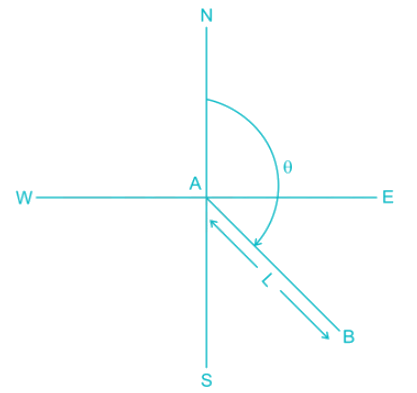
When the whole circle bearing of a traverse line is between 90° and 180° then:

Detailed Solution for Test: Surveying- 1 - Question 6

Latitude = Lcosθ

Departure = Lsinθ

So, for θ lies between 90° to 180°, cos θ is -ve and sin θ is +ve

So, Latitude is -ve and Departure is +ve

Test: Surveying- 1 - Question 7

The horizontal angle between the true meridian and the survey line measured in a clockwise direction is called as:

Detailed Solution for Test: Surveying- 1 - Question 7

True Bearing: It is horizontal distance between the true meridian and the survey line measured in a clockwise direction.

Azimuth: it is the horizontal angle or direction of a compass bearing.

Arbitrary Meridian: Any convenient direction from a survey station to some well defined permanent object is known as arbitrary meridian. This is used for small area survey or to determine the relative directions of small traverse.

Grid Meridian: For survey of country, the true meridian passing through the central place is sometimes taken as a reference meridian for the whole country. Such a meridian is known as Grid meridian.

Test: Surveying- 1 - Question 8

Which of the following is not a temporary adjustment to a compass used for land surveying?

Detailed Solution for Test: Surveying- 1 - Question 8

Temporary Adjustments of Compass are:

1. Fixing the compass to the tripod.

2. Centering the compass: Making the pivot exactly vertically over the ground station mark

3. Levelling the compass

4. Sighting the object: By focusing through prism

5. Observation of bearings

Test: Surveying- 1 - Question 9

GIS deals with which kind of data:

Detailed Solution for Test: Surveying- 1 - Question 9

A Geographic Information System (GIS Software) is designed to store, retrieve, manage, display, and analyze all types of geographic and spatial data.

Test: Surveying- 1 - Question 10

Which one is the CORRECT sequence for the temporary adjustment of the theodolite?

Detailed Solution for Test: Surveying- 1 - Question 10

Temporary Adjustment of Theodolite:

Firstly, Instrument is at set-up at concerned station, Then

1. Cantering: To place the vertical axis exactly over the station mark

2. Levelling: Levelling adjustment of the theodolite is done using levelling screws or foot screws. The objective of levelling in surveying is to make the vertical axis of the instrument truly vertical.

3. Elimination of Parallax: Parallax is the condition arising when the image formed by the objective is not in the plane of crosshairs. This one of important steps in the temporary adjustment of theodolite or telescope.

Test: Surveying- 1 - Question 11

Which one of the following is the largest scale?

Detailed Solution for Test: Surveying- 1 - Question 11

Upon solving,

1/500 = 0.002

1/1000 = 0.001

1/2500 = 0.0004

1/50000 = 0.00002

Largest is 0.002 i.e. 1/500

Test: Surveying- 1 - Question 12

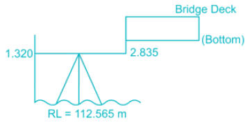
A level instrument at a height of 1.320 m has been placed at a station having a Reduced Level (RL) of 112.565 m. The instrument reads -2.835 m on a levelling staff held at the bottom of a bridge deck. The RL (in m) of the bottom of the bridge deck is

Detailed Solution for Test: Surveying- 1 - Question 12

RL of Bottom of Bridge Deck = 112.565 + 1.320 + 2.835

RL of Bottom of Bridge Deck = 116.720 m.

Test: Surveying- 1 - Question 13

The least count of prismatic compass is:

Detailed Solution for Test: Surveying- 1 - Question 13

The smallest value that can be measured by the measuring instrument is called its Least Count. 

Least count of Prismatic Compass = 30 minutes = 30’

Least Count of surveyor’s Compass = 15 minutes = 15’

Test: Surveying- 1 - Question 14

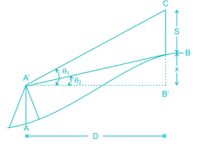
θ1 and θ2 are the angles of elevation form A to the top and bottom of a vertically held rod of length S at B. The horizontal distance AB is

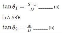
Detailed Solution for Test: Surveying- 1 - Question 14


From (a) and (b)

Test: Surveying- 1 - Question 15

Using two theodolite method, setting out a curve is known as:

Detailed Solution for Test: Surveying- 1 - Question 15

In a two theodolite method, curves are staked out by angular measurements only. Accuracy attained in this method is quite high. Thus the method is used when higher accuracy is required and when the topography is rough or field condition is difficult.

Test: Surveying- 1 - Question 16

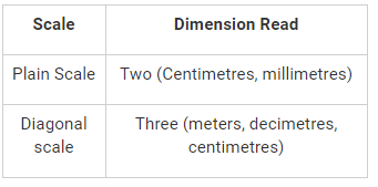
The scale in which three dimensions can be measured is known as?

Detailed Solution for Test: Surveying- 1 - Question 16

Test: Surveying- 1 - Question 17

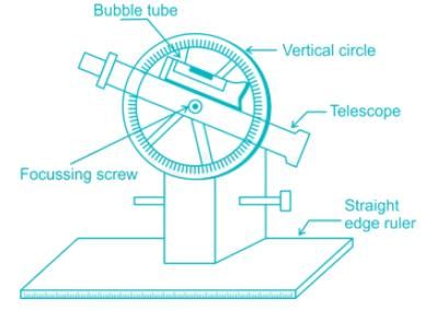
The instrument which is used in plane tabling for obtaining horizontal and vertical distances directly without resorting to chaining, is known as

Detailed Solution for Test: Surveying- 1 - Question 17

Telescopic alidade consists of a telescope mounted on a column fixed to the ruler. The line of sight through the telescope is kept parallel to the bevelled edge of the ruler. The telescope is provided with a level tube and vertical graduation arc. If the horizontal sight is required, bubble in the level tube is kept at the centre.

If inclined sights are required, vertical graduation helps in noting the inclination of the line of sight. By providing telescope the range and the accuracy of the line of sight are increased.

Test: Surveying- 1 - Question 18

Which one of the following statement is CORRECT?

Detailed Solution for Test: Surveying- 1 - Question 18

Curvature correction is negative and refraction correction is positive. If previous reading is less than the next consecutive reading then it will indicate a falling gradient.

Test: Surveying- 1 - Question 19

Which one of the following statements is CORRECT?

Detailed Solution for Test: Surveying- 1 - Question 19

Rise and fall method applies to check on B.S. and F.S., last RL and first RL. Rise and fall method is better than the height of the instrument method.

Test: Surveying- 1 - Question 20

If the vertical curve connects a 1% upgrade with 1.4% downgrade, and the rate of change of grade is to be 0.06% per 20 m stations, the length of a vertical curve is

Detailed Solution for Test: Surveying- 1 - Question 20

Deflection angle, 

Length of the vertical curve, 

1 videos|1 docs|64 tests
Information about Test: Surveying- 1 Page
In this test you can find the Exam questions for Test: Surveying- 1 solved & explained in the simplest way possible. Besides giving Questions and answers for Test: Surveying- 1, EduRev gives you an ample number of Online tests for practice
Download as PDF