SSC MTS Mock Test - 10 - SSC MTS / SSC GD MCQ
30 Questions MCQ Test SSC MTS Mock Test Series 2026 - SSC MTS Mock Test - 10
What is the simple interest for 9 years on a sum of Rs. 800 if the rate of interest for the first 4 years is 8% per annum and for the last 4 years is 6% per annum?
30 men working 5 h a day can do a work in 16 days. In how many days will 20 men working 6 h a day do the same work?
15 men could finish a piece of work in 210 days. But at the end of 100 days, 15 additional men are employed. In how many more days will the work be complete?
The sum of three numbers is 98. The ratio of the first two numbers is 2 : 3 and that of the last two numbers is 5 : 8. Find the 2nd number.
There are two shops, A and B. Shop A gives successive discounts of 60% and 40%, whereas shop B gives successive discounts of 30% and 70%. If the selling price of an article is the same in both the shops, then what is the ratio of marked prices of the article in the two shops?
If A + B means A is the brother of B; A – B means A is the sister of B and A x B means A is the father of B. Which of the following means that C is the son of M?
At a mathematics competition, a professor gives a new definition that a number is called 'defector' if it is impossible to factorise the given number. He then calls a number 'super defector' if the number formed by breaking the number into as many possible smaller numbers ( without re-ordering) and all the numbers so formed are defectors. For example, 123 can be broken into 1, 2, 3, 12, 23 and 123. Note that 13, 32, 21, 31 etc. are not involved.
How many 3-digit numbers are 'super defectors'?
Directions to Solve
In each of the following questions find out the alternative which will replace the question mark.
Question -
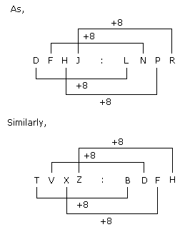
DFHJ : LNPR :: TVXZ : ?
The rows and columns of the left matrix have been labelled as 0, 1, 2, 3, 4 and Q, R, S, T, U, whereas those of the right matrix are 5, 6, 7, 8, 9 and L, M, N, O, P. Find the correct row-column pairs out of these matrices that decode to the word - R4ZE
Mahatma Gandhi undertook fast unto death in 1932, mainly because
What is the objective of the NCC Integrated Software launched by Raksha Mantri Rajnath Singh?
What was the role of KM Vasudevan Namboothiri in the field of art?
What is the aim of the NCC Integrated Software launched by Raksha Mantri Rajnath Singh?
Find the word most appropriate for Blank no. 29
Our study about women’s place in Indian society is mainly based on urban, professional and educated Indian women. Deep in the rural heartland of the country, the rapidly changing world has not even touched the (29)____ of the life of a women. Most men of orthodox families take (30)____ in revealing that their (31)____ folk stay in ‘purdah’, a shield that (32)____ a woman of the joys of free nature. Still more alarming are the (33)____ of atrocities of women (34)____ incidents at Bantala, Singur and Birati are (35)____
DIRECTIONS: The following question contains an idiom and its usage in a sentence, followed by five possible meanings labelled A, B, C, D and E. Pick out the right meaning of the idiom in question and mark your answer accordingly.
Q.
Elbow grease.
He has reached this high stature through "elbow grease".
Because the economic cycle in the United States changes little during its 20-yearinterval between recessing, it is fairly easy for analysts to predict analogous trendsin the stock market.
Direction: The sentences given in the question, when properly sequenced, form a coherent paragraph. Each sentence is labeled with a letter. Choose the most logical order of sentences from the given choices to construct a coherent paragraph.
A. Not long after their victory, the Greeks began to think that they would never stack up to the glories of the past.
B. Throughout antiquity, those warriors, especially the Marathonomachai, who fought and defeated the Persian troops in the 490 BCE Battle of Marathon, would be revered as Athens’ Greatest Generation.
C. Even in the mid-fifth century BCE, Athenians were already looking back with longing.
D. A few decades earlier, Athenian citizen-soldiers had helped to rout the Persian invaders of Greece.
Directions: Out of the given alternatives, choose the one which can be substituted for the given words/sentence.
A person learning a trade under someone
|
116 docs|20 tests
|


