Civil Engineering (CE) Exam  >  Civil Engineering (CE) Tests  >  GATE Civil Engineering (CE) 2025 Mock Test Series  >  Test: Fundamental Concepts, Accuracy & Errors - 1 - Civil Engineering (CE) MCQ

Test: Fundamental Concepts, Accuracy & Errors - 1 - Civil Engineering (CE) MCQ


Test Description

10 Questions MCQ Test GATE Civil Engineering (CE) 2025 Mock Test Series - Test: Fundamental Concepts, Accuracy & Errors - 1

Test: Fundamental Concepts, Accuracy & Errors - 1 for Civil Engineering (CE) 2024 is part of GATE Civil Engineering (CE) 2025 Mock Test Series preparation. The Test: Fundamental Concepts, Accuracy & Errors - 1 questions and answers have been prepared according to the Civil Engineering (CE) exam syllabus.The Test: Fundamental Concepts, Accuracy & Errors - 1 MCQs are made for Civil Engineering (CE) 2024 Exam. Find important definitions, questions, notes, meanings, examples, exercises, MCQs and online tests for Test: Fundamental Concepts, Accuracy & Errors - 1 below.
Solutions of Test: Fundamental Concepts, Accuracy & Errors - 1 questions in English are available as part of our GATE Civil Engineering (CE) 2025 Mock Test Series for Civil Engineering (CE) & Test: Fundamental Concepts, Accuracy & Errors - 1 solutions in Hindi for GATE Civil Engineering (CE) 2025 Mock Test Series course. Download more important topics, notes, lectures and mock test series for Civil Engineering (CE) Exam by signing up for free. Attempt Test: Fundamental Concepts, Accuracy & Errors - 1 | 10 questions in 30 minutes | Mock test for Civil Engineering (CE) preparation | Free important questions MCQ to study GATE Civil Engineering (CE) 2025 Mock Test Series for Civil Engineering (CE) Exam | Download free PDF with solutions
Test: Fundamental Concepts, Accuracy & Errors - 1 - Question 1

Surveys which are carried out to depict mountains, rivers, water bodies, wooded areas and other cultural details, are known as

Detailed Solution for Test: Fundamental Concepts, Accuracy & Errors - 1 - Question 1
  1. Cadastral Survey: To establish a boundary of properties for legal use.
  2. City Survey: Survey of city
  3. Topographical Survey: Surveys which are carried out to depict mountains, rivers, water bodies, wooded areas and other cultural details.
  4. Guide Map Survey: For showing relief by contours and spot heights.
Test: Fundamental Concepts, Accuracy & Errors - 1 - Question 2

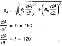
The sides of a rectangle are (120 ± 0.05)m and (180 ± 0.06) m. The probable error in the area will be

Detailed Solution for Test: Fundamental Concepts, Accuracy & Errors - 1 - Question 2

Error of area is given by,


1 Crore+ students have signed up on EduRev. Have you? Download the App
Test: Fundamental Concepts, Accuracy & Errors - 1 - Question 3

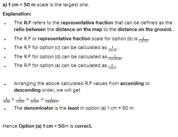
Which of the following scales is largest one?

Detailed Solution for Test: Fundamental Concepts, Accuracy & Errors - 1 - Question 3

Test: Fundamental Concepts, Accuracy & Errors - 1 - Question 4

What is a systematic error?

Detailed Solution for Test: Fundamental Concepts, Accuracy & Errors - 1 - Question 4

Cumulative Errors/Systematic errors:  

(i) The errors that occur in the same direction and which finally tend to accumulate are said to be Cumulative errors.

(ii) They are cumulative in nature. Examples of systematic errors are Collimation in a level, Expansion of steel tape, etc.

(iii) They are proportional to the length of the line.

Test: Fundamental Concepts, Accuracy & Errors - 1 - Question 5

The principle of ‘working from whole to part’ is used in surveying because

Detailed Solution for Test: Fundamental Concepts, Accuracy & Errors - 1 - Question 5

Working from whole to part prevent the accumulation of cumulative errors due to multiple check points and controlled points already set up from which a part can be plotted accurately without depending on the previous plotted point. 

Test: Fundamental Concepts, Accuracy & Errors - 1 - Question 6

Which one of the following surveys is employed for collecting sufficient data in connection with sewage disposal and water supply works?

Detailed Solution for Test: Fundamental Concepts, Accuracy & Errors - 1 - Question 6

Cadastral Survey: to establish a boundary of properties for legal use
Topographical Survey: Surveys which are carried out to depict mountains, rivers, water bodies, wooded areas and other cultural details 
Geodetic Survey: Considering earth’s curvature. Usually used when area to be surveyed is greater than 260 sq.km
Cross-Sectioning and Profile Levelling- Collecting sufficient data in connection with sewage disposal and water supply works
City Survey: survey of city
Guide Map Survey: For showing relief by contours and spot heights. 

Test: Fundamental Concepts, Accuracy & Errors - 1 - Question 7

Theory of errors and adjustments deals with minimizing the effects of

Detailed Solution for Test: Fundamental Concepts, Accuracy & Errors - 1 - Question 7

Systematic or cumulative errors which occurs from well understood causes can be reduced by adopting suitable methods. It follows some definite mathematical or physical iaw and a correction can be-determined and applied.
Accidental errors are those which remain after mistakes and systematic errors have been eliminated and are caused by a combination of reasons beyond the ability of the observer to control. Personal errors arise from the limitations of the human senses such as sight, touch and hearing. Both accidental and personal error represent the limit of precision in the determination of a value. They obey the law of probability and therefore theory of errors and adjustments applies to them.

Test: Fundamental Concepts, Accuracy & Errors - 1 - Question 8

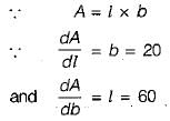
A plot of land 60 m x 20 m is measured by a steel tape. If the standard error of length and width measurements is taken as ±1 cm, then the standard error of the area of the plot would be

Detailed Solution for Test: Fundamental Concepts, Accuracy & Errors - 1 - Question 8

Standard error of area is given by,

Test: Fundamental Concepts, Accuracy & Errors - 1 - Question 9

Which one of the following closely represent the shape of the earth?

Detailed Solution for Test: Fundamental Concepts, Accuracy & Errors - 1 - Question 9

The actual shape of the earth is an oblate spheroid, it is an ellipsoid of revolution, flattened at the poles and bulging at the equator. The-length of the polar axis is about 12, 113.168 km and that of equatorial axis is about 12, 756.602 km. Thus polar axis is shorter than the equatorial axis by about 43.434 km.

Test: Fundamental Concepts, Accuracy & Errors - 1 - Question 10

The representative fraction 1/2500 means that the scale 1 cm is equal to

Detailed Solution for Test: Fundamental Concepts, Accuracy & Errors - 1 - Question 10

Representative Fraction = 1/2500
Scale 1 cm equal to x metre  1cm/(x metre) = 1/100x = 1/2500
Therefore, x = 25 m

31 docs|280 tests
Information about Test: Fundamental Concepts, Accuracy & Errors - 1 Page
In this test you can find the Exam questions for Test: Fundamental Concepts, Accuracy & Errors - 1 solved & explained in the simplest way possible. Besides giving Questions and answers for Test: Fundamental Concepts, Accuracy & Errors - 1, EduRev gives you an ample number of Online tests for practice

Top Courses for Civil Engineering (CE)

Download as PDF

Top Courses for Civil Engineering (CE)