UPSC Exam  >  UPSC Tests  >  Geography for UPSC CSE  >  Test: India - Location - 1 - UPSC MCQ

Test: India - Location - 1 - UPSC MCQ


Test Description

10 Questions MCQ Test Geography for UPSC CSE - Test: India - Location - 1

Test: India - Location - 1 for UPSC 2024 is part of Geography for UPSC CSE preparation. The Test: India - Location - 1 questions and answers have been prepared according to the UPSC exam syllabus.The Test: India - Location - 1 MCQs are made for UPSC 2024 Exam. Find important definitions, questions, notes, meanings, examples, exercises, MCQs and online tests for Test: India - Location - 1 below.
Solutions of Test: India - Location - 1 questions in English are available as part of our Geography for UPSC CSE for UPSC & Test: India - Location - 1 solutions in Hindi for Geography for UPSC CSE course. Download more important topics, notes, lectures and mock test series for UPSC Exam by signing up for free. Attempt Test: India - Location - 1 | 10 questions in 10 minutes | Mock test for UPSC preparation | Free important questions MCQ to study Geography for UPSC CSE for UPSC Exam | Download free PDF with solutions
Test: India - Location - 1 - Question 1

Which of the following statement(s) is/are true?

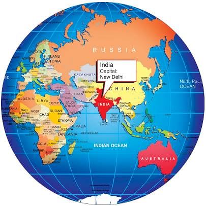
Statement I: The Tropic of Cancer passes through the southernmost point of India.

Statement II: Indian Standard Time (IST) is based on the 82°30' E longitude.

Detailed Solution for Test: India - Location - 1 - Question 1

Statement I is incorrect. The Tropic of Cancer does not pass through the southernmost point of India; it passes through the middle of the country.

Statement II is correct. Indian Standard Time (IST) is indeed based on the 82°30' E longitude.

Test: India - Location - 1 - Question 2

Which of the following statement(s) is/are correct?

i. The standard meridian of India is 82°30' E longitude.

ii. India’s coastline is the longest in the world.

iii. The southernmost point of India is Kanniyakumari.

iv. India extends from 6°45' N latitude to 37°6' N latitude.

Detailed Solution for Test: India - Location - 1 - Question 2

Statement i- Correct. The standard meridian of India is indeed 82°30' E longitude.

Statement ii- Incorrect. India does not have the longest coastline in the world; that title belongs to Canada.

Statement iii- Incorrect. The southernmost point of India is actually Indira Point in the Andaman and Nicobar Islands, not Kanniyakumari.

Statement iv- Correct. The country extends from 6°45' N latitude to 37°6' N latitude.

1 Crore+ students have signed up on EduRev. Have you? Download the App
Test: India - Location - 1 - Question 3

Which of the given below statement(s) is/are correct?
i: India’s latitudinal extent results in diverse climatic conditions across the country.
ii: The distance between two longitudes decreases as one moves towards the poles.
iii: India’s easternmost point experiences sunrise before its westernmost point.
iv: The Indian Standard Time is based on the 68°7' E longitude.

Detailed Solution for Test: India - Location - 1 - Question 3
  • Statement i is correct as India’s vast latitudinal extent does lead to diverse climatic conditions.
  • Statement ii is correct because the distance between longitudes indeed decreases towards the poles.
  • Statement iii is correct since the easternmost point of India experiences sunrise earlier than the westernmost point.
  • Statement iv is incorrect as the Indian Standard Time (IST) is based on the 82°30' E longitude, not 68°7' E.
Test: India - Location - 1 - Question 4

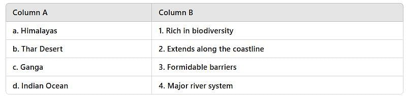
Arrange the following geographical features of India in the correct chronological order based on their formation or significance:

1. Formation of the Himalayas

2. Establishment of the Indian Standard Time

3. Development of the Ganga River system

4. Recognition of India's varied ecosystems

Detailed Solution for Test: India - Location - 1 - Question 4

- The Himalayas were formed millions of years ago due to tectonic activity.

- The Ganga River system developed as a result of the geographical and hydrological processes following the formation of the Himalayas.

- The recognition of India's varied ecosystems came with the study of its diverse geography and climate.

- The establishment of Indian Standard Time was a much later development in the context of timekeeping and standardization.

Test: India - Location - 1 - Question 5

Assertion (A): India shares its borders with several countries in South Asia, including Pakistan, Nepal, and Bhutan.

Reason (R): The geographical location of India allows it to maintain maritime links with its neighboring countries through the Indian Ocean.

Detailed Solution for Test: India - Location - 1 - Question 5
  • The Assertion is correct because India indeed shares its borders with Pakistan, Nepal, and Bhutan, among others.
  • The Reason is also correct as India's geographical location facilitates maritime connections with its neighbors through the Indian Ocean.
  • The Reason provides a correct explanation for the Assertion, as the maritime links are a direct result of India's geographical positioning.
  • Therefore, since both the Assertion and Reason are true, and the Reason explains the Assertion correctly, the correct answer is Option A.
Test: India - Location - 1 - Question 6

In the Asian continent, India is located at the

Detailed Solution for Test: India - Location - 1 - Question 6

India is located in the southern part of the Asian continent. It shares its land borders with seven countries on three sides - Pakistan, Afghanistan, China, Nepal, Bhutan, Myanmar, and Bangladesh.

Test: India - Location - 1 - Question 7

Match the following-


Detailed Solution for Test: India - Location - 1 - Question 7

- The Himalayas serve as natural barriers to the north of India.

- The Thar Desert is known for its unique ecosystem and biodiversity, though it is a harsh environment.

- The Ganga River is one of India's most significant and extensive river systems.

- The Indian Ocean borders the southern part of India, contributing to its extensive coastline.

Test: India - Location - 1 - Question 8

Which of the following statement(s) about India's geography is/are correct?

i. India extends approximately 3,214 km from north to south and 2,933 km from east to west.

ii. The southernmost point of India lies at 6°45' N latitude in the Arabian Sea.

iii. The standard meridian of India is 82°30' E, which is ahead of GMT by 5 hours and 30 minutes.

iv. The geographical area of India includes regions in the tropics and sub-tropical zones.

Detailed Solution for Test: India - Location - 1 - Question 8

- Statement i is correct as it accurately describes the distance from north to south (3,214 km) and east to west (2,933 km).

- Statement ii is incorrect because the southernmost point of India, Kanniyakumari, is located at approximately 8°04' N latitude, not 6°45' N.

- Statement iii is correct since the standard meridian of India is indeed 82°30' E, which is 5 hours and 30 minutes ahead of GMT.

- Statement iv is correct as India spans both tropical and sub-tropical regions.

Thus, the correct statements are i, iii, and iv, making Option A the correct answer.

Test: India - Location - 1 - Question 9

India's longitudinal extent leads to which of the following challenges?

Detailed Solution for Test: India - Location - 1 - Question 9

India’s longitudinal extent, ranging from 68°7' E to 97°25' E, causes a significant time difference between its easternmost and westernmost points, nearly two hours. This challenge is mitigated by adopting 82°30' E as the standard meridian.

Test: India - Location - 1 - Question 10

Assertion (A): India's geographical location contributes to significant climatic variations across the country.

Reason (R): The latitudinal extent of India is approximately 30o, resulting in diverse ecosystems and weather patterns.

Detailed Solution for Test: India - Location - 1 - Question 10
  • The assertion is correct; India's geographical location indeed leads to a wide range of climatic conditions due to its size and positioning between the tropics and the temperate zones.
  • The reason is also correct. The significant latitudinal extent does contribute to varying ecosystems and weather patterns across different regions of India.
  • The reason effectively explains the assertion, as it highlights the role of latitude in creating climatic diversity, which aligns with the assertion about India's geographical influence on climate. Therefore, both the assertion and reason are true, and the reason is the correct explanation of the assertion.
180 videos|475 docs|195 tests
Information about Test: India - Location - 1 Page
In this test you can find the Exam questions for Test: India - Location - 1 solved & explained in the simplest way possible. Besides giving Questions and answers for Test: India - Location - 1, EduRev gives you an ample number of Online tests for practice

Top Courses for UPSC

180 videos|475 docs|195 tests
Download as PDF

Top Courses for UPSC