SSC CGL Exam  >  SSC CGL Tests  >  SSC CGL Tier 2 - Study Material, Online Tests, Previous Year  >  Map Based Test - 6 - SSC CGL MCQ

Map Based Test - 6 - SSC CGL MCQ


Test Description

30 Questions MCQ Test SSC CGL Tier 2 - Study Material, Online Tests, Previous Year - Map Based Test - 6

Map Based Test - 6 for SSC CGL 2024 is part of SSC CGL Tier 2 - Study Material, Online Tests, Previous Year preparation. The Map Based Test - 6 questions and answers have been prepared according to the SSC CGL exam syllabus.The Map Based Test - 6 MCQs are made for SSC CGL 2024 Exam. Find important definitions, questions, notes, meanings, examples, exercises, MCQs and online tests for Map Based Test - 6 below.
Solutions of Map Based Test - 6 questions in English are available as part of our SSC CGL Tier 2 - Study Material, Online Tests, Previous Year for SSC CGL & Map Based Test - 6 solutions in Hindi for SSC CGL Tier 2 - Study Material, Online Tests, Previous Year course. Download more important topics, notes, lectures and mock test series for SSC CGL Exam by signing up for free. Attempt Map Based Test - 6 | 30 questions in 35 minutes | Mock test for SSC CGL preparation | Free important questions MCQ to study SSC CGL Tier 2 - Study Material, Online Tests, Previous Year for SSC CGL Exam | Download free PDF with solutions
Map Based Test - 6 - Question 1

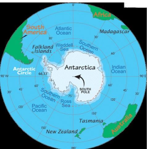
Which are the water borders shared by Antarctica?

1. Pacific Ocean

2. Atlantic Ocean

3. Indian Ocean

4. Artie Ocean

Detailed Solution for Map Based Test - 6 - Question 1
It is the southernmost continent and is surrounded by the Southern Ocean ie, alternatively it may be considered to be surrounded by the southern pacific, Atlantic and Indian ocean.

Map Based Test - 6 - Question 2

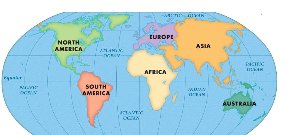
Which is the ocean which is almost completely surrounded by Eurasia and N. America ?

Detailed Solution for Map Based Test - 6 - Question 2
 

1 Crore+ students have signed up on EduRev. Have you? Download the App
Map Based Test - 6 - Question 3

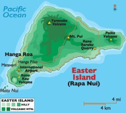
Where is the famous Easter island located?

Detailed Solution for Map Based Test - 6 - Question 3
Located out in the Pacific ocean, a special territory of chile, is a home to Moai statues that are the only thing left of a culture that once lived here.

Located in the south-eastern Pacific ocean, at the southeastern most point of the Polynesian Triangle in Oceania.

Map Based Test - 6 - Question 4

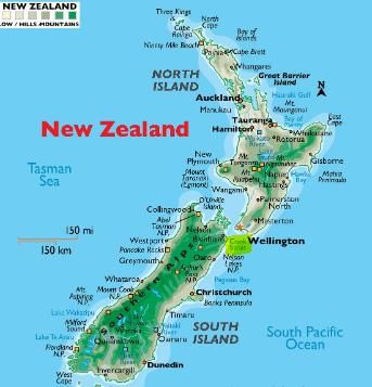
Which Strait lies between the North & South Islands of New Zealand and runs next to the capital city, Wellington?

Detailed Solution for Map Based Test - 6 - Question 4

It connects the Tasman Sea on the northwest with South Pacific Ocean on the southeast

Map Based Test - 6 - Question 5

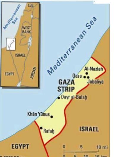
Which are the boundaries shared by Gaza Strip?

1. Egypt

2. Israel

3. Dead sea

4. Mediterranean Sea

5. Jordan

Detailed Solution for Map Based Test - 6 - Question 5
It borders Egypt-southwest and Israel-east & north, along with eastern coast of Mediterranean sea.

Map Based Test - 6 - Question 6

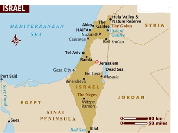
Which are the water bodies bordering Israel?

1. Dead sea

2. Red sea

3. Mediterranean Sea

4. sea of Galilee

Detailed Solution for Map Based Test - 6 - Question 6
Israel shares its water boundaries with Mediterranean Sea-southeast, Red Sea-north, dead sea and Sea of Galilee.

Map Based Test - 6 - Question 7

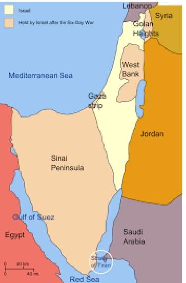
Which strait separates the Gulf of Aqaba from the Red Sea?

Detailed Solution for Map Based Test - 6 - Question 7
It's a narrow passage between Sinai and Arabian peninsulas which separates Gulf of Aqaba from the Red Sea.

Map Based Test - 6 - Question 8

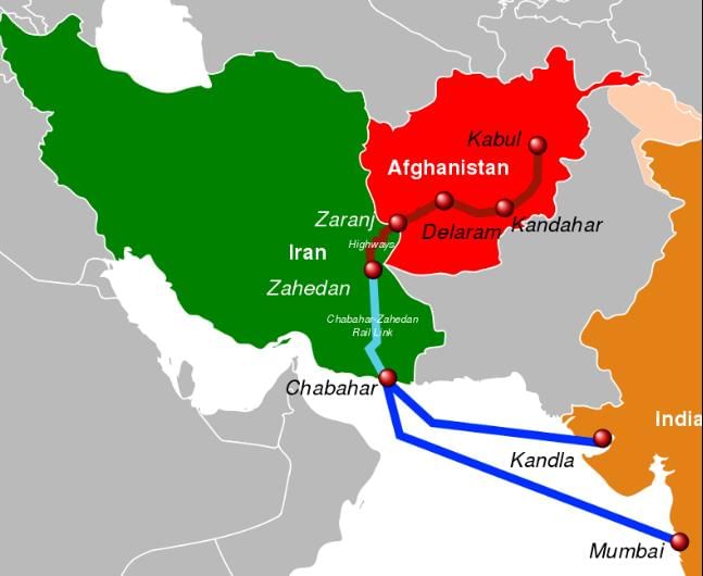
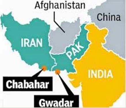
Which is the only Iranian port with direct access to the Indian Ocean?

Detailed Solution for Map Based Test - 6 - Question 8

Map Based Test - 6 - Question 9

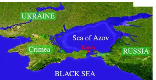
Which are the boundaries shared by the Sea of Azov?

1. Ukraine

2. Russia 

3. Crimean Peninsula

4. Turkey

Detailed Solution for Map Based Test - 6 - Question 9


Map Based Test - 6 - Question 10

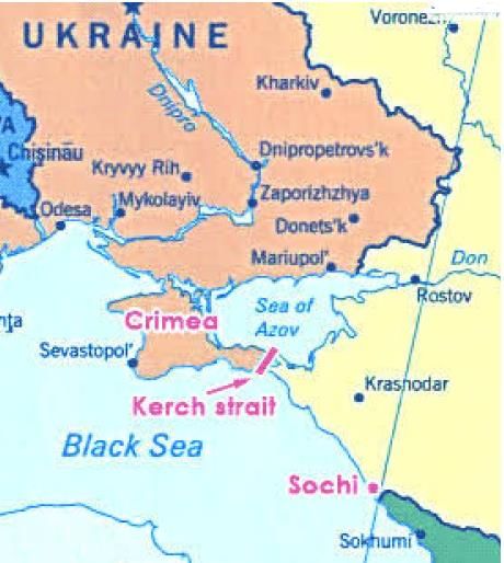
Which strait links of Azov?

Detailed Solution for Map Based Test - 6 - Question 10

Map Based Test - 6 - Question 11

Taurus strait Joins which two seas?

Detailed Solution for Map Based Test - 6 - Question 11
 

Map Based Test - 6 - Question 12

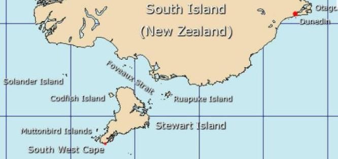
Foveaux is a strait in between?

Detailed Solution for Map Based Test - 6 - Question 12


Map Based Test - 6 - Question 13

Which is the only Iranian port with direct access to the Indian Ocean?

Detailed Solution for Map Based Test - 6 - Question 13
It is a seaport in Chabahar located in southeastern Iran, on the Gulf of Oman. It is the only Iranian port with direct access to the Indian Ocean It has been termed the "Golden Gate"

Chabahar Port: 

Map Based Test - 6 - Question 14

Which of the following are listed as Alpha ++ cities?

1. London

2. New York

3. Washington

4. Singapore

Detailed Solution for Map Based Test - 6 - Question 14
 
  • Alpha++ cities are vastly more integrated with the global economy than all other cities.

  • Alpha++ world cities: London, New York Every few years, cities are ranked by the Globalization and World Rankings Research Institute. It is considered the leading institute ranking world cities.

  • Cities are ranked into Alpha, Beta and Gamma cities by taking into account many factors; economic factors are deemed more important than cultural or political factors though in this ranking.

Map Based Test - 6 - Question 15

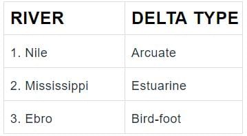
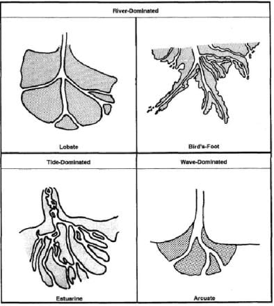
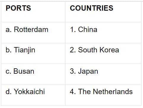
Which of the following pairs is/are correctly matched?

Detailed Solution for Map Based Test - 6 - Question 15
 

Map Based Test - 6 - Question 16

Which of the following are correctly matched?

WIND

1. Khamsin

2. Blizzard

3. Gibli

COUNTRY

1. Egypt

2. Russia

3. Libya

Detailed Solution for Map Based Test - 6 - Question 16
 

Map Based Test - 6 - Question 17

Which river is termed as the 'Sorrow of Una'?

Detailed Solution for Map Based Test - 6 - Question 17
 
  1. Swan river in Una district of Himachal Pradesh. Swan river is termed as the 'sorrow of Una'. It is a river tributary of river Sutlej. 

  2. The Swan River Integrated Watershed Management Project came into being in 2006-07with the financial assistance from Japan International Cooperation Agency (JICA). 

  3. Himachal Forest Department is the nodal agency of this project. Besides that, the Department of Agriculture, Horticulture and Animal Husbandry of the state are the participants of the project.

Map Based Test - 6 - Question 18

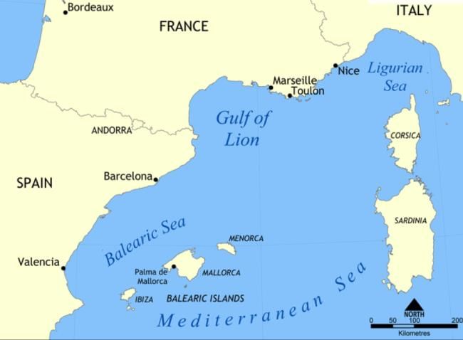
Where is Gulf of Lions situated?

Detailed Solution for Map Based Test - 6 - Question 18
 

Map Based Test - 6 - Question 19

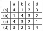
Match the following pairs correctly.

Codes:

Detailed Solution for Map Based Test - 6 - Question 19

Map Based Test - 6 - Question 20

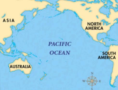
Which water body separates Asia and Australia from America?

Detailed Solution for Map Based Test - 6 - Question 20

Map Based Test - 6 - Question 21

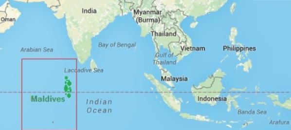
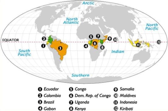
Through which Asian countries does the Equator pass?

1. Maldives

2. Indonesia

3. Kiribati

4. Malaysia

Detailed Solution for Map Based Test - 6 - Question 21

Countries the Equator Passes Through.

Map Based Test - 6 - Question 22

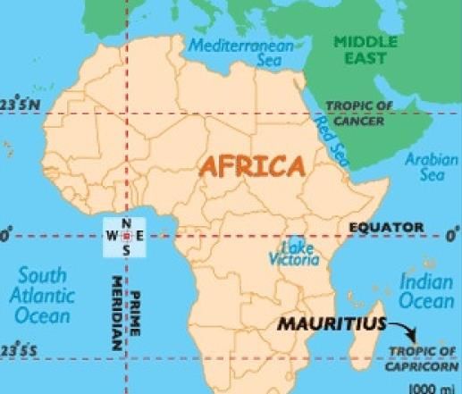
Which of the following places are known for the presence of great Sun Temples in India?

1. Unao, MP

2. Surya Prahar, Assam

3. Arasavalli, AP

4. Gaya, Bihar

Detailed Solution for Map Based Test - 6 - Question 22

Bhramanya Dev Temple, Unao, MP

Sun Temple, Surya Prahar, Assam

Suryanar temple, Kumbakonam, TN

Suryanarayana Swamy temple, Arasavalli, AP

The Dakshinaarka temple, Gaya, Bihar

Konark Sun Temple, konark, Orissa

Sun Temple, Mdhera, Gujarath

Map Based Test - 6 - Question 23

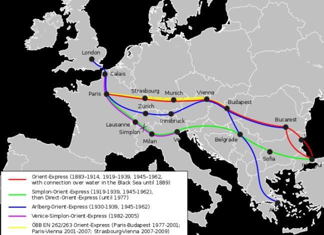
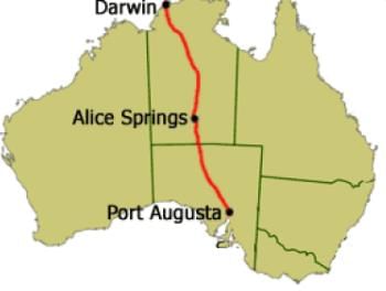
Which of the following pair(s) is/are not correctly matched?

1. Trans-caucasus railway - South America

2. Orient express. - Europe

3. Stuart highway. - Australia

4. Mid-trans Continental - North America Rail route

Detailed Solution for Map Based Test - 6 - Question 23
Transcaucasus Railway - South Caucasus(Russia)

Map Based Test - 6 - Question 24

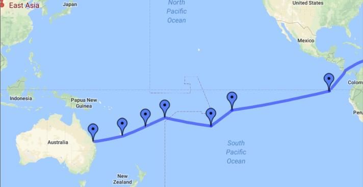
Which of the following statements is/are correct?

1. Mediterranean waterway joins together the maximum number of countries in the world.

2. The South Pacific Oceanic Route joins Australia, New Zealand and East Asian countries together.

3. cape of good hope sea route joins Eastern Asia and Europe to Southern parts of Africa.

Detailed Solution for Map Based Test - 6 - Question 24
 

Map Based Test - 6 - Question 25

Which Canal connects Pacific Ocean with the Atlantic Ocean?

Detailed Solution for Map Based Test - 6 - Question 25
Panama is a country on the isthmus linking Central and South America. The Panama Canal, a famous feat of human engineering, cuts through its center, linking the Atlantic and Pacific oceans to create an essential shipping route.

Map Based Test - 6 - Question 26

Which of the following states was formed exclusively by the migrants in the 20th century?

Detailed Solution for Map Based Test - 6 - Question 26
 

Map Based Test - 6 - Question 27

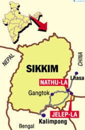
Consider the following about Jelep La pass

1. situated between Sikkim and China border

2. It passes through Chumbi Valley

3. It also links china & Lhasa

Which is/are correct statement/s?

Detailed Solution for Map Based Test - 6 - Question 27
 

Map Based Test - 6 - Question 28

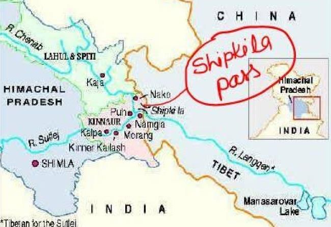
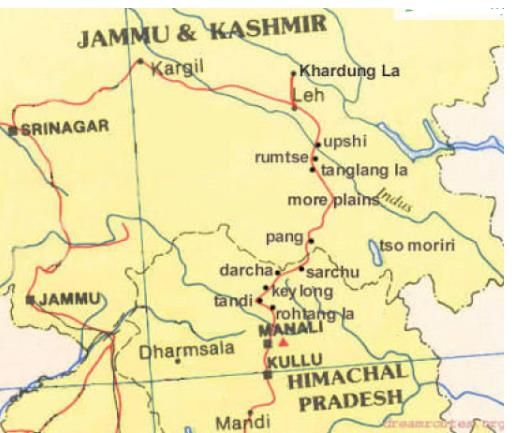
Which is the major pass present in between Himachal Pradesh and Tibet through which Sutlej river enters India?

Detailed Solution for Map Based Test - 6 - Question 28
 

Map Based Test - 6 - Question 29

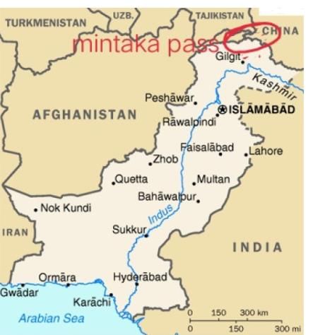
Which mountain pass is present in the tri junction of India-China-Afghanistan border?

Detailed Solution for Map Based Test - 6 - Question 29

Map Based Test - 6 - Question 30

Which mountain pass is present in the Ladakh region and opens as a gateway to Shyok and Nubra Valleys?

Detailed Solution for Map Based Test - 6 - Question 30

It's the Highest Motorable pass in India.

1365 videos|1312 docs|1010 tests
Information about Map Based Test - 6 Page
In this test you can find the Exam questions for Map Based Test - 6 solved & explained in the simplest way possible. Besides giving Questions and answers for Map Based Test - 6, EduRev gives you an ample number of Online tests for practice

Top Courses for SSC CGL

Download as PDF

Top Courses for SSC CGL