Test: Plane Table Surveying & Calculation of Area & Volume - 1 - Civil Engineering (CE) MCQ
10 Questions MCQ Test GATE Civil Engineering (CE) 2026 Mock Test Series - Test: Plane Table Surveying & Calculation of Area & Volume - 1
The process of determining the locations of the instrument station by drawing resectors from the locations of the. known stations is called
The methods used for locating the plane table stations are
1. radiation
2. traversing
3. intersection
4. resection
The correct answer is
1. radiation
2. traversing
3. intersection
4. resection
The instrument which is used in plane tabling for obtaining horizontal and vertical distances directly without resorting fo chaining, is known as
Orientation of a plane table by solving two point problem is only adopted when
For locating an inaccessible point with the help of only a Plane table, one should use
Three point problem can be solved by
Consider the following statements pertaining to plane table survey
1. Two point problem is solved by mechanical method
2. Three point problem is solved by Bessel’s method
3. In two point problem, auxiliary station is required
Which of these statements is/are correct?
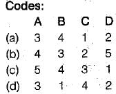
Match List-I (Statement) with List-Il (Situation) and select the correct answer using the codes given below the lists:
List-I
A. Accurate centering in plane table surveying is necessary for
B. Exact orientation is more important than accurate centering for
C. The intersection method of plane table surveying is particularly employed for
D. Plane table survey is useful for
List-II
1. Inaccessible points
2. Open country with good intervisibility
3. Large scale maps
4. Small scale maps
5. Hilly regions

The method of orienting a plane table with two inaccessible points is known as
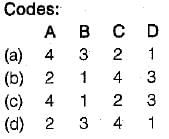
Match List-l (Methods) with List-II (Procedures) and select the correct answer using the codes given below the lists:
List-I
A. Traversing
B. Resection
C. intersection
D. Radiation
Ltst-ll
1. Rays are drawn to locate the station on which the table is set-up
2. At least two rays are drawn from two different stations to the details to be located
3. Rays are drawn in the direction of details through ine station point on which the table is set-up
4. Rays ace drawn on the map by setting up the table over each of the stations towards the subsequent station

|
33 docs|291 tests
|


