Civil Engineering (CE) Exam  >  Civil Engineering (CE) Tests  >  Geomatics Engineering (Surveying)  >  Test: Traverse Surveying - Civil Engineering (CE) MCQ

Test: Traverse Surveying - Civil Engineering (CE) MCQ


Test Description

10 Questions MCQ Test Geomatics Engineering (Surveying) - Test: Traverse Surveying

Test: Traverse Surveying for Civil Engineering (CE) 2024 is part of Geomatics Engineering (Surveying) preparation. The Test: Traverse Surveying questions and answers have been prepared according to the Civil Engineering (CE) exam syllabus.The Test: Traverse Surveying MCQs are made for Civil Engineering (CE) 2024 Exam. Find important definitions, questions, notes, meanings, examples, exercises, MCQs and online tests for Test: Traverse Surveying below.
Solutions of Test: Traverse Surveying questions in English are available as part of our Geomatics Engineering (Surveying) for Civil Engineering (CE) & Test: Traverse Surveying solutions in Hindi for Geomatics Engineering (Surveying) course. Download more important topics, notes, lectures and mock test series for Civil Engineering (CE) Exam by signing up for free. Attempt Test: Traverse Surveying | 10 questions in 30 minutes | Mock test for Civil Engineering (CE) preparation | Free important questions MCQ to study Geomatics Engineering (Surveying) for Civil Engineering (CE) Exam | Download free PDF with solutions
Test: Traverse Surveying - Question 1

_______ is the sum of meridian distance of two ends of line. 

Detailed Solution for Test: Traverse Surveying - Question 1

The double meridian distance of a line is equal to the sum of the meridian distances of the two extremities, which is useful for the determination of the required area of the plot.

  • The sum of the meridian distances of the ends of a survey line.
  • In practice, assuming a closed traverse with the meridian of reference passing through the initial station, the double meridian distance (DMD) of the first course (line) is equal to the departure of that course; the double meridian distance of each succeeding course (line) is equal to the double meridian distance of the preceding course, plus the departure of the preceding course, plus the departure of the course itself.
  • If the DMD of each course is multiplied by the latitude of the corresponding course, double areas are obtained, from which the area of the tract can be obtained.
  • By a strictly analogous procedure, double parallel distances (DPD) can be computed, using the latitudes of the successive courses instead of departures, and using an east-west line as the reference parallel.
Test: Traverse Surveying - Question 2

Co ordinate length measured parallel to an assumed meridian direction may be defined as _________

Detailed Solution for Test: Traverse Surveying - Question 2

Answer: a
Explanation: The latitude of the survey line may be defined as its coordinate length measured parallel to an assumed meridian direction. True north or magnetic north or any other reference direction.

1 Crore+ students have signed up on EduRev. Have you? Download the App
Test: Traverse Surveying - Question 3

_________ is a method in the field of surveying to establish control networks

Detailed Solution for Test: Traverse Surveying - Question 3

Traverse is a method in the field of surveying to establish control networks.

Test: Traverse Surveying - Question 4

Which method is used for making angular measurements, When triangulation (Triangulation surveying) is not possible?

Detailed Solution for Test: Traverse Surveying - Question 4

Traverse surveying: 

  • A traverse is a series of connected lines whose lengths and directions are to be measured and the process of surveying to find such measurements is known as traversing.
  • In Traverse, surveying measurements are carried out in a long series of interconnected survey lines, either from a closed or an open traverse.
  • In general, chains are used to measure the length and a compass or theodolite is used to measure the direction of traverse lines.
  • Methods of traversing: 1. Chain traversing 2. Compass traversing 3. Theodolite traversing  4. Plane table Traversing.

​Cadastral surveying: 

  • These involve determination and plotting boundary locations of individual land holding and/or laying out new property boundaries.

Topographic surveying: 

  • For the preparation of plans and maps delineating natural and man-made surface features and ground undulations.  

Hydrographic surveying: 

  • To obtain information and data about underwater features of the ground, e.g. showing shorelines, water depths, the shape of the river bed, and other marine features.
Test: Traverse Surveying - Question 5

In which direction latitude of the line is positive?

Detailed Solution for Test: Traverse Surveying - Question 5

The latitude of the line is positive when measured northward. It is termed as northing.

Test: Traverse Surveying - Question 6

Which of the following are Traverse networks advantages?

Detailed Solution for Test: Traverse Surveying - Question 6

All of the above are Advantages of Traverse networks.

Test: Traverse Surveying - Question 7

The directions of survey lines are fixed by angular measurements and not by forming a network of triangles. This statement is true for which type of surveying?

Detailed Solution for Test: Traverse Surveying - Question 7

Principle of Compass Surveying :

  • In compass traversing the directions of survey lines are fixed by angular measurements and not by forming a network of triangles.
  • A compass survey is one in which the traverse work consists of a series of lines the lengths and directions of which are measured with a chain or a tape, and with an angular instrument respectively.

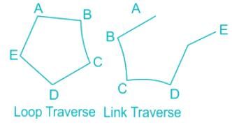
A traverse may be classified as:
Closed traverse (link traverse):

  • A closed traverse is a traverse in which the sides of a traverse form a closed polygon.

Open traverse (loop traverse):

  • An open traverse is a traverse in which the sides of the traverse do not form a closed polygon.

Test: Traverse Surveying - Question 8

In which direction latitude of the line is negative?

Detailed Solution for Test: Traverse Surveying - Question 8

The latitude of the line is negative when measured southward. It is termed as southing.

Test: Traverse Surveying - Question 9

How many types of traverse?

Detailed Solution for Test: Traverse Surveying - Question 9

There are mainly two types of traverse: closed and open.

Test: Traverse Surveying - Question 10

The magnetic bearing of line AB is 132° 45'. If the magnetic declination is 10° 20'W, the true bearing of the line AB will be

Detailed Solution for Test: Traverse Surveying - Question 10

Magnetic declination: At any place horizontal angle between true meridian and magnetic meridian is called magnetic declination.
For Eastern Declination:
α = β + θe or T.B = M.B + θe
Here, α = True bearing (T.B)
β = Magnetic bearing (M.B), and
θE = Eastern declination
For Western Declination:
α = β – θw or T.B = M.B – θw
Here, θw = western declination.
Calculation:
Magnetic bearing of a line AB = 132°45’
Declination = 10°20’ West
∴ True bearing = 132°45’ - 10°20’ = 122°25' = S57°35’E

19 videos|31 docs|35 tests
Information about Test: Traverse Surveying Page
In this test you can find the Exam questions for Test: Traverse Surveying solved & explained in the simplest way possible. Besides giving Questions and answers for Test: Traverse Surveying, EduRev gives you an ample number of Online tests for practice

Up next

Download as PDF

Up next