Geography: CUET Mock Test - 1 - CUET MCQ
30 Questions MCQ Test CUET Mock Test Series - Geography: CUET Mock Test - 1

Griffith Taylor introduced _____ in human geography.
What is the MAIN reason people move to cities in India?

Which of the following is NOT a challenge associated with rapid urbanisation in India
what is a KEY strategy for India to manage the challenges of urbanisation
Which of the following states in India has the highest percentage of its population living in urban areas
Which one of the following is termed as middle path between the two ideas of environmental determinism and possibilism?
Consider the following statements with respect to the concept of neo-determinism:
1. Humans can depart from directions as indicated by the natural environment.
2. Vice man follows nature’s plan only if he is wise.
Which of the above statement(s) is/are incorrect?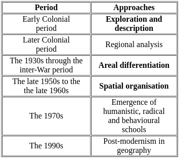
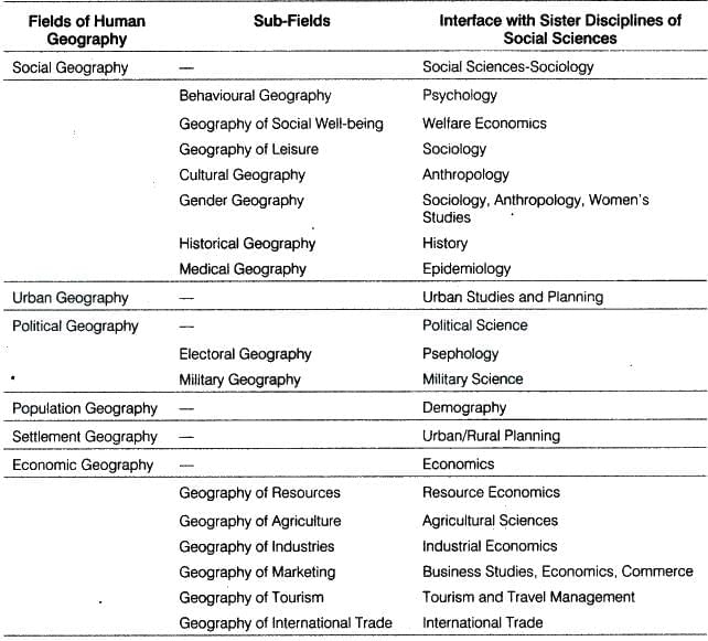
Which of the following are the fields/subfields of the study of human geography?
1. Geography of Leisure
2. Military Geography
3. Geography of Technology
4. Electoral Geography
5. Geography of Marketing
Identify the correct answer from the codes given below.
Consider the following statements regarding Population:
A. The way in which people are spread across the earth surface is known as the pattern of population distribution.
B. More than 90 per cent of the world’s population lives in about 30 percent of the land surface.
C. The distribution of population in the world is extremely uneven.
Choose the correct option?
Which of the following statements is INCORRECT about migration in India?
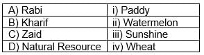
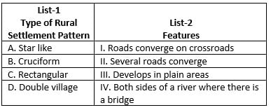
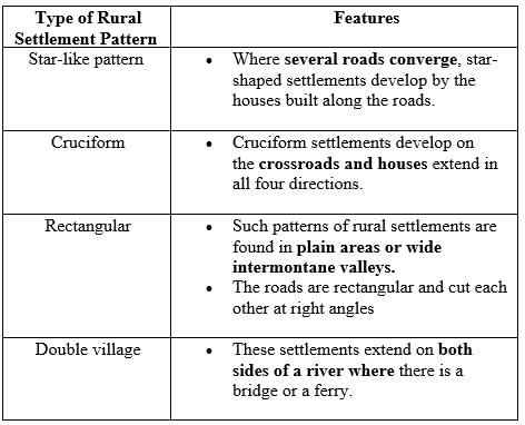
Match List I with List II
Choose the correct answer from the options given below:
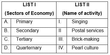
Match List I with List II
Choose the correct answer from the options given below:
Which of the following is NOT an example of human intervention causing soil erosion?
There are two statements given below, marked as Assertion (A) and Reason (R). Read the statements and choose the correct option.
Assertion (A): Soil erosion is increasing in India.
Reason (R): The causes of soil erosion differ from one place to another.
Which category of land use will increase due to soil erosion?
Which of the following is the primary cause for the pressure on land resources?
Which category of land use will increase due to soil erosion?
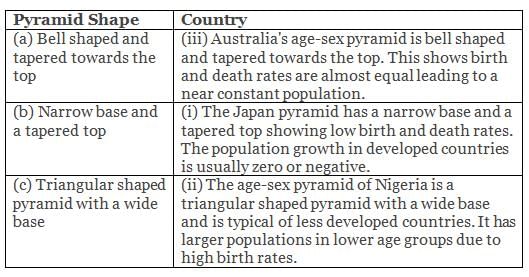
Match the following age-sex pyramids with their respective countries:
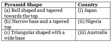
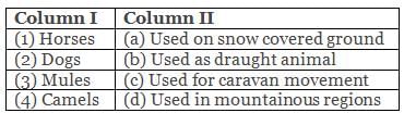
Directions: Match the contents under column I with those under column II.
Which of the following is NOT an institutional or technological reform in agriculture?
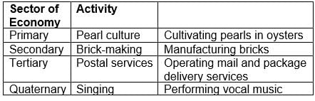
Which of the following is a sub-discipline of economic geography?
|
39 docs|148 tests
|


Important Questions for Geography: CUET Mock Test - 1
Geography: CUET Mock Test - 1 MCQs with Answers
Online Tests for Geography: CUET Mock Test - 1 CUET Mock Test Series
|
© EduRev
|
Education Revolution
|


|


