Geography: CUET Mock Test - 2 - CUET MCQ
30 Questions MCQ Test CUET Mock Test Series - Geography: CUET Mock Test - 2

Directions: Read the following passage carefully:
Haryali is a watershed development project which aims at enabling the rural population to conserve water for drinking, irrigation, fisheries and afforestation. Under this initiative, all ongoing area development programmes namely, Integrated Wastelands Development Programme (IWDP), Drought Prone Areas Programme (DPAP) and Desert Development Programme (DDP) will be implemented through Panchayati Raj Institutions w.e.f. April 2003. As the Watershed Development Programmes aim at holistic development of watershed areas, the convergence of all other non-land based programmes of Government of India, particularly those of the Ministry of Rural Development would enhance the ultimate output and lead to sustainable economic development of the village community. The ZP/DRDA therefore, shall take all-possible measures to ensure convergence of other programmes of the Ministry of Rural Development such as the Sampoorna Grameen Rozgar Yojana (SGRY), the Swarnjayanti Gram Swarozgar Yojana (SGSY) the Indira Awas Yojana (IAY), the Total Sanitation Campaign (TSC) and the Rural Drinking Water Supply Programme in the village chosen for the implementation of the watershed development projects.
Q. In which year was Haryali, a watershed development project, launched?

In ____ milk is supplied through pipelines from farms to factories.
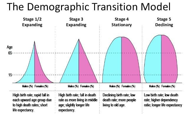
In which of the following demographic transition stages, both fertility and mortality rates are high?
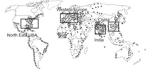
Which one of the following cluster regions in the world are great clusters of population?
Directions: Read the following passage carefully:
Haryali is a watershed development project which aims at enabling the rural population to conserve water for drinking, irrigation, fisheries and afforestation. Under this initiative, all ongoing area development programmes namely, Integrated Wastelands Development Programme (IWDP), Drought Prone Areas Programme (DPAP) and Desert Development Programme (DDP) will be implemented through Panchayati Raj Institutions w.e.f. April 2003. As the Watershed Development Programmes aim at holistic development of watershed areas, the convergence of all other non-land based programmes of Government of India, particularly those of the Ministry of Rural Development would enhance the ultimate output and lead to sustainable economic development of the village community. The ZP/DRDA therefore, shall take all-possible measures to ensure convergence of other programmes of the Ministry of Rural Development such as the Sampoorna Grameen Rozgar Yojana (SGRY), the Swarnjayanti Gram Swarozgar Yojana (SGSY) the Indira Awas Yojana (IAY), the Total Sanitation Campaign (TSC) and the Rural Drinking Water Supply Programme in the village chosen for the implementation of the watershed development projects.
Q. The Neeru-Meeru programme in ______ and Arvary Pani Sansad in _______ have taken up constructions of various water-harvesting structures.
Directions: Read the following passage carefully:
Haryali is a watershed development project which aims at enabling the rural population to conserve water for drinking, irrigation, fisheries and afforestation. Under this initiative, all ongoing area development programmes namely, Integrated Wastelands Development Programme (IWDP), Drought Prone Areas Programme (DPAP) and Desert Development Programme (DDP) will be implemented through Panchayati Raj Institutions w.e.f. April 2003. As the Watershed Development Programmes aim at holistic development of watershed areas, the convergence of all other non-land based programmes of Government of India, particularly those of the Ministry of Rural Development would enhance the ultimate output and lead to sustainable economic development of the village community. The ZP/DRDA therefore, shall take all-possible measures to ensure convergence of other programmes of the Ministry of Rural Development such as the Sampoorna Grameen Rozgar Yojana (SGRY), the Swarnjayanti Gram Swarozgar Yojana (SGSY) the Indira Awas Yojana (IAY), the Total Sanitation Campaign (TSC) and the Rural Drinking Water Supply Programme in the village chosen for the implementation of the watershed development projects.
Q. Ralegan Siddhi, a village of _________, has become an example for watershed development throughout the country.
Directions: Read the following passage carefully:
Haryali is a watershed development project which aims at enabling the rural population to conserve water for drinking, irrigation, fisheries and afforestation. Under this initiative, all ongoing area development programmes namely, Integrated Wastelands Development Programme (IWDP), Drought Prone Areas Programme (DPAP) and Desert Development Programme (DDP) will be implemented through Panchayati Raj Institutions w.e.f. April 2003. As the Watershed Development Programmes aim at holistic development of watershed areas, the convergence of all other non-land based programmes of Government of India, particularly those of the Ministry of Rural Development would enhance the ultimate output and lead to sustainable economic development of the village community. The ZP/DRDA therefore, shall take all-possible measures to ensure convergence of other programmes of the Ministry of Rural Development such as the Sampoorna Grameen Rozgar Yojana (SGRY), the Swarnjayanti Gram Swarozgar Yojana (SGSY) the Indira Awas Yojana (IAY), the Total Sanitation Campaign (TSC) and the Rural Drinking Water Supply Programme in the village chosen for the implementation of the watershed development projects.
Q. Which state has made water harvesting structures in the houses compulsory?
Directions: Read the following passage carefully:
Haryali is a watershed development project which aims at enabling the rural population to conserve water for drinking, irrigation, fisheries and afforestation. Under this initiative, all ongoing area development programmes namely, Integrated Wastelands Development Programme (IWDP), Drought Prone Areas Programme (DPAP) and Desert Development Programme (DDP) will be implemented through Panchayati Raj Institutions w.e.f. April 2003. As the Watershed Development Programmes aim at holistic development of watershed areas, the convergence of all other non-land based programmes of Government of India, particularly those of the Ministry of Rural Development would enhance the ultimate output and lead to sustainable economic development of the village community. The ZP/DRDA therefore, shall take all-possible measures to ensure convergence of other programmes of the Ministry of Rural Development such as the Sampoorna Grameen Rozgar Yojana (SGRY), the Swarnjayanti Gram Swarozgar Yojana (SGSY) the Indira Awas Yojana (IAY), the Total Sanitation Campaign (TSC) and the Rural Drinking Water Supply Programme in the village chosen for the implementation of the watershed development projects.
Q. Consider the following statements with regard to India's National Water Policy and mark the correct option.
Statement I: The first National Water Policy was adopted in September, 1987.
Statement II: The National Water Policy 2002 stipulates primitive approaches to water management.
Which of the following is not a commercial crop in India?
Which one of the following countries has the highest sex ratio in the world?
Which Port is situated at the head of Vembanad Kayal, popularly known as the ‘Queen of the Arabian Sea’?
Given below are two statements: One is labelled as Assertion (A) and the other is labelled as Reason (R) :
Assertion (A): In areas of intensive subsistence agriculture animal husbandry is a meagre sideline of crop farming
Reasons (R): Throughout the region, the farmers are handicapped in raising cattle due to a lack of scientific methods of breeding the animals.
Q. In light of the above statements choose the most appropriate answer from the options given below:
Autobahns a term for roadways is used in which country?
Which method of soil conservation is most suitable in the coastal and dry regions?
Which of the following are not the part of continuous landmass?
Which is the major rail route of Russia that runs from St. Petersburg in the west to Vladivostok on the Pacific Coast?
Which one of the following is NOT the part of the definition of a town as per the census of India?
Petrochemicals are used in the manufacture of________.
Which group of profession from the following came under tertiary sector of economy?
Which of the following sentence is correctly define slum?
Which of the following is the name the three stages of demographic transition theory?
In which of the following regions has the oldest well-documented urban settlement found?
|
8 docs|148 tests
|


Important Questions for Geography: CUET Mock Test - 2
Geography: CUET Mock Test - 2 MCQs with Answers
Online Tests for Geography: CUET Mock Test - 2 CUET Mock Test Series
|
© EduRev
|
Education Revolution
|


|


