CUET Exam  >  CUET Tests  >  CUET Mock Test Series  >  Geography: CUET Mock Test - 6 - CUET MCQ

Geography: CUET Mock Test - 6 - CUET MCQ


Test Description

30 Questions MCQ Test CUET Mock Test Series - Geography: CUET Mock Test - 6

Geography: CUET Mock Test - 6 for CUET 2025 is part of CUET Mock Test Series preparation. The Geography: CUET Mock Test - 6 questions and answers have been prepared according to the CUET exam syllabus.The Geography: CUET Mock Test - 6 MCQs are made for CUET 2025 Exam. Find important definitions, questions, notes, meanings, examples, exercises, MCQs and online tests for Geography: CUET Mock Test - 6 below.
Solutions of Geography: CUET Mock Test - 6 questions in English are available as part of our CUET Mock Test Series for CUET & Geography: CUET Mock Test - 6 solutions in Hindi for CUET Mock Test Series course. Download more important topics, notes, lectures and mock test series for CUET Exam by signing up for free. Attempt Geography: CUET Mock Test - 6 | 50 questions in 45 minutes | Mock test for CUET preparation | Free important questions MCQ to study CUET Mock Test Series for CUET Exam | Download free PDF with solutions
Geography: CUET Mock Test - 6 - Question 1

Which among the following statements is correct in context of human geography?

Detailed Solution for Geography: CUET Mock Test - 6 - Question 1

Houses, villages, cities, road-rail networks, industries, farms, ports, items of our daily use and all other elements of material culture have been created by human beings using the resources provided by the physical environment. While physical environment has been greatly modified by human beings, it has also, in turn, impacted human lives.

Geography: CUET Mock Test - 6 - Question 2

Paper industry is mainly associated with which of the following industries?

Detailed Solution for Geography: CUET Mock Test - 6 - Question 2

Forest - basedKey Points

  • Forest-based:
    • The paper industry is directly associated with forest-based industries as it primarily relies on wood pulp and other plant materials for the production of paper.
    • Trees provide the cellulose fibers needed for paper manufacturing, making forest resources crucial for the industry.
    • Responsible management and sustainable practices within forest-based industries are essential to ensure a continuous supply of raw materials for paper production, highlighting the interdependence between forestry and the paper industry.

Additional Information

  • Mineral-based:
    • Mineral-based industries focus on extracting and processing minerals, which is quite distinct from the paper industry's reliance on organic, renewable resources like wood and plant fibers.
    • While minerals might be used in some ancillary processes or as fillers in paper production, the core raw material comes from forests, not mined minerals.
  • Agro-based:
    • Although agro-based industries also utilize plant materials, they are primarily concerned with the production of food, fibers, and other agricultural products, not specifically paper.
    • Some agricultural residues can be used as raw materials in papermaking, but the industry's mainstay is forest wood pulp.
  • Chemical-based:
    • The paper industry does use chemicals in the processing of paper, including bleaching and pulping chemicals, but it is not primarily a chemical-based industry.
    • The foundation of the industry is the physical raw material from forests, although chemicals are crucial for transforming this raw material into paper.

In conclusion, the paper industry's primary association with forest-based industries is due to its reliance on wood and other plant materials as fundamental raw materials for paper production, distinguishing it from mineral, agro, or chemical-based industries

Geography: CUET Mock Test - 6 - Question 3

The first complete population census in India was conducted in which of the following years?

Detailed Solution for Geography: CUET Mock Test - 6 - Question 3

The correct answer is 1881.

Key Points

  • The first complete population census in India was conducted in the year 1881. This was a landmark event in the history of Indian demography.
  • The census was conducted under the reign of the then Viceroy of India, Lord Ripon. His administration is credited with initiating this massive statistical exercise.
  • This census laid down the framework for future censuses in India, establishing a systematic method for collecting and recording demographic data.
  • The 1881 census was a significant achievement as it was the first attempt to cover the entire population of India under a single administrative effort. It marked the beginning of a decennial census tradition, which continues in India to this day.
  • It provided valuable insights into the population's size, distribution, and various social and economic characteristics, serving as a crucial tool for planning and administration.

Additional Information

  • While the 1881 census was the first complete census, there were earlier attempts at conducting population counts in India. The earliest known attempt was in 1872, but it was not comprehensive and did not cover the entire territory of India.
  • The census has evolved over the years, incorporating new technologies and methodologies to improve accuracy and efficiency in data collection and analysis.
  • The data collected from the census plays a critical role in the country's planning and development, including resource allocation, urban planning, and social welfare programs.
Geography: CUET Mock Test - 6 - Question 4
Which one is the pattern of rural settlement?
Detailed Solution for Geography: CUET Mock Test - 6 - Question 4

The correct answer is Linear.

Important Points

  • The pattern of settlement is defined as the relationship between one house or building to another. It can be identified by reading and observing a local scale map. The patterns of a settlement deal with compact and semi-compact only, as dispersed has its shape. Socio-cultural factors like caste structure or the functional need of people have a close bearing on their shape and size.

Key Points

  • The rural settlements are classified under the following patterns: Rectangular, Linear, Circular, Semi-circular, Star-like, Triangular, and Nebular Pattern. The settlements are linear in valleys and mountainous areas, rectangular in fertile plains, circular near the lakes and ponds, triangular at crossroads, and exceptional cases resemble the nebular form and on river terraces it is star-type.
  • Patterns of rural settlements indicate the way the houses are placed about each other. The position of the village, the neighboring topography, and the terrain impact the size and shape of a village.
  • Rural settlements may be classified based on some criteria: Based on the setting- The main classes are plain villages, coastal villages, plateau villages, desert villages, and forest villages.
  • Based on functions: There may be farming villages, lumberjack villages, fisherman’s villages, pastoral villages, etc.
  • Based on forms or configurations of the settlements: These may be several geometrical patterns and shapes such as Linear, rectangular, T-shaped villages, circular star-like villages, double villages, cross-shaped villages, etc.
  • Linear pattern: In such settlements houses are established along a road, river, railway line, or canal edge of a valley. A linear settlement is a (typically little to medium-sized) settlement or gathering of structures that is framed in a long queue. Linear settlements may have no undeniable focus, for example, a street intersection. Linear settlements have a long and restricted shape.
  • The linear form is comprised of buildings along a road, river, dike, or seacoast. Excluding the mountainous zones, the agricultural land is extended behind the buildings. The river can supply the people with a water source and the availability to travel and communicate. Roads were constructed parallel to the river for access to inland farms. In this way, a new linear settlement can emerge along each road, parallel to the original riverfront settlement.

Additional Information

  • A scattered dispersed type of rural settlement is generally found in a variety of landforms, such as the foothill, tableland, and upland regions. Yet, the proper scattered village is found at the highest elevations and reflects the rugged terrain and pastoral economic life. The population maintains many traditional features in architecture, dress, and social customs, and the old market centers are still important. Small plots and dwellings are carved out of the forests and on the upland pastures wherever physical conditions permit. Mining, livestock raising, and agriculture are the main economic activities, the latter characterized by terrace cultivation on the mountain slopes. The sub-mountain regions, with hills and valleys covered by plowed fields, vineyards, orchards, and pastures, typically have this type of settlement.
  • Compact Settlements: If the total number of hamlets equals the total number of villages in an area unit then the settlement is known as a compact settlement. Compact settlements are found all over the plateau region of Malwa, large parts of Rajasthan, Uttar Pradesh, Nimar upland, the Vindhyan Plateau, the Narmada Valley, and other cultivated parts of India.
  • Semi-compact Settlements: A settlement is considered semi-compact when the overall number of villages exceeds half of the hamlets. These settlements are found in both plateaus and plains that depend on the prevailing environmental conditions in those areas. The dwellings in semi-compact Settlements are not tightly linked and are gathered at a single location. It extends further than the compact settlement.
Geography: CUET Mock Test - 6 - Question 5
Which of the following factors is most important in determining whether a community is an urban settlement?
Detailed Solution for Geography: CUET Mock Test - 6 - Question 5

The correct answer is Economic activity

Key PointsUrban settlement

  • Urban settlements indulge in non-agricultural activities e.g. industries and manufacturing, trade and commerce, transport and communication, defence and administration.
  • The definition of urban areas varies from one country to another. Some of the common bases of classification are the size of the population, occupational structure and administrative setup.
    • Population Size: The lower limit of the population size for a settlement to be designated as urban is 1,500 in Colombia, 2,000 in Argentina and Portugal, 2,500 in U.S.A. and Thailand, 5,000 in India and 30,000 in Japan. Besides the size of the population, the density of 400 persons per sq km and the share of non-agricultural workers are taken into consideration in India.
    • Occupational Structure: In some countries, such as India, the major economic activities in addition to the size of the population in designating a settlement as urban are also taken as a criterion
    • Administration: The administrative setup is a criterion for classifying a settlement as urban in some countries. For example, in India, a settlement of any size is classified as urban, if it has a municipality, Cantonment Board or Notified Area Council.
Geography: CUET Mock Test - 6 - Question 6

Which among the following factors influence the density distribution of the population in India?

1. Amount of rainfall

2. Cultural factors

3. Distribution of minerals

4. Fertility of soils

Select the correct answer from the options given below.
Detailed Solution for Geography: CUET Mock Test - 6 - Question 6
  • An uneven spatial distribution of population in India suggests a close relationship between population and physical, socioeconomic and historical factors.
  • As far as the physical factors are concerned, it is clear that climate along with terrain and availability of water largely determines the pattern of the population distribution.
  • Consequently, we observe that the North Indian Plains, deltas and Coastal Plains have higher proportion of population than the interior districts of southern and central Indian States, Himalayas, some of the north eastern and the western states.
  • However, development of irrigation (Rajasthan), availability of mineral and energy resources (Jharkhand) and development of transport network (Peninsular States) have resulted in moderate to high concentration of population in areas which were previously very thinly populated.
  • Among the socio-economic and historical factors of distribution of population, the important ones are:
    • evolution of settled agriculture and agricultural development
    • pattern of human settlement
    • development of transport network, industrialisation and urbanisation.
    • It is observed that the regions falling in the river plains and coastal areas of India have remained the regions of larger population concentration.
    • Even though the uses of natural resources like land and water in these regions have shown signs of degradation, the concentration of population remains high because of an early history of human settlement and development of transport networks.
    • On the other hand, the urban regions of Delhi, Mumbai, Kolkata, Bengaluru, Pune, Ahmedabad, Chennai and Jaipur have high concentration of population due to industrial development and urbanisation drawing a large number of rural-urban migrants.
Geography: CUET Mock Test - 6 - Question 7
At present, which ‘age-group’ is in majority in Indian population?
Detailed Solution for Geography: CUET Mock Test - 6 - Question 7

The correct answer is Working age population

Key Points

  • India has a relatively young population, with a significant portion of its population in the working-age group of 15-64 years.
  • the working population of India, which includes the 15-64 age group, comprises 68% of the total population.
  • This scenario highlights the potential of India reaping the demographic dividend in the years to come

Geography: CUET Mock Test - 6 - Question 8

Consider the following pairs regarding the different Age-Groups:

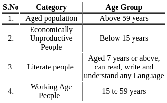
How many pairs is/are correctly matched?

Detailed Solution for Geography: CUET Mock Test - 6 - Question 8

The correct answer is option 4.Key PointsAge-Groups:

  • The population of a nation is, generally grouped into three broad categories:
    • Children (generally below 15 years): They are economically unproductive and need to be provided with food, clothing, education and medical care. Hence pair 2 is correctly matched.
    • Working Age (15–59 years): They are economically productive and biologically reproductive. They comprise the working population. Hence pair 4 is correctly matched.
    • Aged (Above 59 years): They can be economically productive though they may have retired. Hence pair 1 is correctly matched.
    • They may be working voluntarily but they are not available for employment through recruitment.
    • According to the Census 2011, a person aged 7 years and above, who can read and write with understanding in any language, is treated as literate. Hence pair 3 is correctly matched.
  • Hence Option 4 is correct.
Geography: CUET Mock Test - 6 - Question 9

What is one of the strategies mentioned in the passage to cope with the impacts of climate change?

Detailed Solution for Geography: CUET Mock Test - 6 - Question 9

The correct answer is ​Adjusting agricultural practices.

  • The extended passage specifically mentions adaptation strategies to cope with the impacts of climate change, including "developing resilience to climate change impacts by adjusting agricultural practices, building designs, and coastal management."
  • Therefore, the correct answer is that adjusting agricultural practices is one of the strategies to cope with the impacts of climate change.
Geography: CUET Mock Test - 6 - Question 10

The  passage mentions the importance of climate models in understanding the interactions between various elements. Which of the following is NOT listed as one of these elements?

Detailed Solution for Geography: CUET Mock Test - 6 - Question 10

The correct answer is Forest
The passage mentions that climate models are essential for simulating interactions between specific elements, including "atmosphere, oceans, land, and ice." Forests are not listed among these elements in the context of the passage, making option c) the correct answer for this question.

Geography: CUET Mock Test - 6 - Question 11

What global effort is mentioned in the passage as aiming to mitigate climate change?

Detailed Solution for Geography: CUET Mock Test - 6 - Question 11

The correct answer is ​Paris Agreement
Paris Agreement
The Paris Agreement, adopted in 2015, is a legally binding international treaty on climate change. Its main goal is to limit global warming to well below 2 degrees Celsius (preferably to 1.5 degrees Celsius) compared to pre-industrial levels.
Here's how it aims to mitigate climate change:
Commitment to Reduction Targets:

  • Countries that are part of the Paris Agreement have committed to setting nationally determined contributions (NDCs) to reduce their greenhouse gas emissions.

Global Stocktake:

  • Every five years, a global stocktake will assess collective progress towards achieving the purpose of the Agreement and its long-term goals.

Financial Support:

  • Developed countries are required to provide financial resources to assist developing countries in both mitigation and adaptation efforts.

Promoting Cooperation:

  • The Agreement promotes voluntary cooperation among its signatories to achieve their NDCs through internationally transferred mitigation outcomes.

Monitoring and Reporting:

  • A transparency framework ensures that countries report on emissions and efforts to reduce them transparently and accurately.

If the passage in question were to discuss current international efforts to combat climate change, the Paris Agreement would likely be the most relevant answer among the options provided.

Geography: CUET Mock Test - 6 - Question 12

What tool is especially important in understanding and predicting climate change?

Detailed Solution for Geography: CUET Mock Test - 6 - Question 12

The correct answer is ​ Climate models.
Climate Models
Climate models are mathematical representations of the Earth's climate system. They are based on physical, chemical, and biological principles and are used to simulate the interactions of the atmosphere, oceans, land surface, and ice. These models can be incredibly complex, as they must take into account various factors that influence climate, including greenhouse gas concentrations, solar radiation, cloud formation, ocean currents, and more.
Why Climate Models are Essential:
Understanding Climate Dynamics:

  • Climate models help scientists understand the underlying dynamics of climate systems, including how different factors interact and influence one another.

Predicting Future Changes:

  • By adjusting parameters such as greenhouse gas emissions, scientists can use climate models to predict how the climate might change in the future under different scenarios.

Assessing Impacts: Climate models are used to assess potential impacts of climate change on various sectors, including agriculture, water resources, ecosystems, and human health.
Informing Policy:

  • Climate models provide critical information to policymakers, helping them to make informed decisions about mitigation and adaptation strategies.

While other tools like weather balloons, barometers, and thermometers are vital for meteorological observations and short-term weather forecasting, they do not have the same capacity to analyze and predict long-term climate change. Climate models are specifically designed to deal with the complexities of climate systems, making them the most relevant tool for understanding and predicting climate change.

Geography: CUET Mock Test - 6 - Question 13

What is the primary focus of climatology?

Detailed Solution for Geography: CUET Mock Test - 6 - Question 13

The correct answer is ​Long-term weather patterns.

  •  Climatology primarily focuses on the study of long-term weather patterns and climate. While daily weather events and short-term trends might be studied in meteorology, climatology is more concerned with understanding and analyzing the averages, variations, and patterns of weather conditions over extended periods (usually 30 years or more).
  • Long-term weather patterns include the study of various climatic phenomena like temperature, humidity, wind patterns, and precipitation over long time scales. These factors are analyzed to understand the underlying trends, anomalies, and cycles that influence the climate in a given region.
  • Understanding long-term weather patterns (Option b) is essential for predicting future climate changes, planning agriculture, developing water management strategies, and creating policies to mitigate the impacts of climate change.
  • This focus differentiates climatology from other areas of atmospheric science, such as meteorology, which emphasizes shorter-term weather forecasting. Therefore, the correct answer to the question is indeed b) Long-term weather patterns.
Geography: CUET Mock Test - 6 - Question 14

What is the primary driver of international cooperation and foreign policies, as mentioned in the passage?

Detailed Solution for Geography: CUET Mock Test - 6 - Question 14

The primary driver of international cooperation and foreign policies, as mentioned in the passage, is:Option 2) The extraction of fossil fuels and minerals
The primary driver of international cooperation and foreign policies, as indicated in the passage, is the extraction of fossil fuels and minerals. Here's an elaboration: 

  • Resource Competition: Throughout recent history, nations have been in competition to secure access to valuable mineral resources, particularly oil and gas. 
  • Energy Trading Relationships: The competition for energy resources has shaped international cooperation and relationships. Countries engage in energy trading, forming alliances and agreements to secure their energy needs. 
  • Geopolitical Risks: Many of the world's oil and gas reserves are located in politically unstable or fragile regions. 
  • Transition to Cleaner Energy: In recent years, there has been a global drive to transition away from fossil fuels like oil and gas toward cleaner and more sustainable energy sources. 
  • Stranded Assets and Opportunities: As countries shift towards cleaner energy sources in alignment with goals like the Paris Agreement, there are consequences for nations heavily reliant on oil exports. 
  • Resource Extraction and Conflict Risks: The extraction of not only fossil fuels but also minerals and other resources can have wide-ranging consequences.

In summary, the extraction of fossil fuels and minerals is a key driver of international cooperation and foreign policies due to its central role in energy production and its geopolitical significance. The transition to cleaner energy sources adds complexity to this dynamic, with both risks and opportunities for countries and the global community.

Geography: CUET Mock Test - 6 - Question 15

What risk do oil-exporting economies specifically face during the transition away from fossil fuels?

Detailed Solution for Geography: CUET Mock Test - 6 - Question 15

The risk that oil-exporting economies specifically face during the transition away from fossil fuels is:
Option 2) Stranded assets

  • As countries shift toward cleaner energy sources and reduce their reliance on fossil fuels like oil.
  •  There is a risk that the oil-exporting economies will have assets (such as oil reserves and infrastructure) that lose value or become obsolete.
  • These stranded assets can be a significant economic challenge for these nations as the demand for their primary export diminishes.

so the correct answer is Stranded assets

Geography: CUET Mock Test - 6 - Question 16

According to the passage, what should be a priority for countries in the context of the energy transition?

Detailed Solution for Geography: CUET Mock Test - 6 - Question 16

According to the passage, a priority for countries in the context of the energy transition should be:
Option 4) Supporting carbon-neutral development in resource-poor countries

  • The passage emphasizes the importance of providing special attention and support to countries with fewer resources to develop in a carbon-neutral way. This indicates that supporting carbon-neutral development in resource-poor countries is a priority.

​​thus the correct answer is Supporting carbon-neutral development in resource-poor countries

Geography: CUET Mock Test - 6 - Question 17

What consequences are associated with the increased extraction of fossil fuels and minerals, as stated in the passage?

Detailed Solution for Geography: CUET Mock Test - 6 - Question 17

The consequences associated with the increased extraction of fossil fuels and minerals, as stated in the passage, are:
Option 3) Geopolitical risks and conflicts

  • The passage mentions that both the increased extraction of fossil fuels, minerals, and other resources, along with shifting global demand patterns, have wide-ranging consequences, including pollution, social disputes, and even conflict.

​thus the correct answer  is Geopolitical risks and conflicts

Geography: CUET Mock Test - 6 - Question 18

What role does climate diplomacy play in addressing the challenges of the energy transition?

Detailed Solution for Geography: CUET Mock Test - 6 - Question 18

the correct answer is Option 3) It offers tools and entry points for mitigating risks.
Climate diplomacy plays a role in addressing the challenges of the energy transition by offering tools and entry points for mitigating the risks associated with the transition away from fossil fuels, as mentioned in the passage.

Geography: CUET Mock Test - 6 - Question 19

Which of the following sea routes connects Western Europe to Australia via the Panama Canal?

Detailed Solution for Geography: CUET Mock Test - 6 - Question 19

This sea route connects Western Europe and North America with Australia, New Zealand and the scattered Pacific islands via the Panama Canal. This route is also used for reaching Hong Kong, Philippines and Indonesia. The distance covered between Panama and Sydney is 12,000 km. Honolulu is an important port on this route.

Geography: CUET Mock Test - 6 - Question 20

Name the gauge in which distance between the rails is 0.762 metre or 0.610 metre.

Detailed Solution for Geography: CUET Mock Test - 6 - Question 20

Narrow gauge: The distance between the rails in this case is 0.762 metre or 0.610 metre. The total length of the narrow gauge was 1604 km (2019-20). It is generally confined to hilly areas.

Geography: CUET Mock Test - 6 - Question 21

Which of the following would lead to urbanisation?

Detailed Solution for Geography: CUET Mock Test - 6 - Question 21

Urbanisation refers to the population shift from rural to urban areas, the corresponding decrease in the proportion of people living in rural areas, and the ways in which societies adapt to this change. Only option 4 specifies an example where there is a shift from rural to urban areas for settlement. Temporary transactions with urban areas, with no intention to settle in such areas, cannot be regarded as urbanisation. Thus, options 2 and 3 are incorrect. Option 1 is also incorrect as there is no movement from rural to urban areas.

Geography: CUET Mock Test - 6 - Question 22

Where in Brazil did more than 100 heads of states meet for the inaugural International Earth Summit in June 1992?

Detailed Solution for Geography: CUET Mock Test - 6 - Question 22

Rio de Janeiro Earth Summit, 1992: In June 1992, more than 100 heads of states met in Rio de Janeiro in Brazil, for the first International Earth Summit. The Summit was convened for addressing urgent problems of environmental protection and socio-economic development at the global level.

Geography: CUET Mock Test - 6 - Question 23

Where and when did the first railway line for the general public open?

Detailed Solution for Geography: CUET Mock Test - 6 - Question 23

The revolution in transport came about only after the invention of the steam engine in the eighteenth century. Perhaps the first public railway line was opened in 1825 between Stockton and Darlington in northern England and then onwards, railways became the most popular and fastest form of transport in the nineteenth century. It opened up continental interiors for commercial grain farming, mining and manufacturing in the USA.

Geography: CUET Mock Test - 6 - Question 24

Which of the following statements is/are true in context of ferrous mineral and their presence in India?

Detailed Solution for Geography: CUET Mock Test - 6 - Question 24

Ferrous minerals such as iron ore, manganese, chromite, etc., provide a strong base for the development of metallurgical industries. Our country is well placed in respect of ferrous minerals both in reserves and production.

Geography: CUET Mock Test - 6 - Question 25

Which of the following statements regarding alluvial soils is/are true?

Statement I: The Himalayan river systems deposit alluvial soils in the south of India, giving rise to the entire southern plains.
Statement II: On the basis of age, alluvial soil can be categorised into three kinds.

Detailed Solution for Geography: CUET Mock Test - 6 - Question 25

Alluvial soil is the most widely spread and important soil. In fact, the entire northern plains are made of alluvial soils. These have been deposited by three important Himalayan river systems – the Indus, the Ganga and the Brahmaputra. Alluvial soils also extend in Rajasthan and Gujarat through a narrow corridor. Alluvial soil is also found in the eastern coastal plains particularly in the deltas of the Mahanadi, the Godavari, the Krishna and the Kaveri rivers. Apart from the size of their grains or components, these soils are also described on the basis of their age - old alluvial (bangar) and new alluvial (khadar). The bangar soil has higher concentration of kanker nodules than the khadar. It has more fine particles and is more fertile than the bangar.

Geography: CUET Mock Test - 6 - Question 26

In which year was the Indian National Satellite System (INSAT) established?

Detailed Solution for Geography: CUET Mock Test - 6 - Question 26

On the basis of configuration and purposes, satellite system in India can be grouped into two: Indian National Satellite System (INSAT) and Indian Remote Sensing Satellite System (IRS). The INSAT, which was established in 1983, is a multi-purpose satellite system for telecommunication, meteorological observation and for various other data and programmes.

Geography: CUET Mock Test - 6 - Question 27

Which of the following is not the pattern of rural settlement?

Detailed Solution for Geography: CUET Mock Test - 6 - Question 27

The rural settlements can be classified on the basis of forms or shapes of the settlements. These may be a number of geometrical forms and shapes such as linear, rectangular, circular, star-like, T-shaped village, double village, cross-shaped village, etc.

Geography: CUET Mock Test - 6 - Question 28

Which of the following statements about Agenda 21 is/are true?

Detailed Solution for Geography: CUET Mock Test - 6 - Question 28

It is the declaration signed by world leaders in 1992 at the United Nations Conference on Environment and Development (UNCED), which took place in Rio de Janeiro, Brazil. It aims at achieving global sustainable development. It is an agenda to combat environmental damage, poverty, and disease through global cooperation on common interests, mutual needs, and shared responsibilities. One major objective of Agenda 21 is that every local government should draw its own local Agenda 21.

Geography: CUET Mock Test - 6 - Question 29

Gathering is usually practised in __________.

Detailed Solution for Geography: CUET Mock Test - 6 - Question 29

Gathering is practised in high latitude zones which include Northern Canada, Northern Eurasia and Southern Chile, and in low latitude zones such as the Amazon Basin, tropical Africa, Northern fringe of Australia and the interior parts of Southeast Asia.

Geography: CUET Mock Test - 6 - Question 30

_____________ was introduced by the government of India in 2015 to address the issue of decline in child sex ratio.

Detailed Solution for Geography: CUET Mock Test - 6 - Question 30

The Government of India introduced the Beti Bachao Beti Padhao Programme to address the issue of decline in child sex ratio. It is a central government scheme for girl child which is applicable throughout the country. The key objective of this scheme is to save the girl child from social ills such as gender-biased abortions and advance the education of girl children all over the country. This scheme was initially targeted at districts that were recognised to have low sex ratio, i.e. fewer female children as compared to male children, but was later expanded to include other parts of the country as well. This is primarily an education-based initiative to help change social attitudes and does not involve direct cash transfer. Key objectives of this social welfare scheme for girl child include preventing gender-biased selective abortions, ensuring survival and protection of girl child in infancy, and ensuring education and participation of the girl child.

View more questions
39 docs|148 tests
Information about Geography: CUET Mock Test - 6 Page
In this test you can find the Exam questions for Geography: CUET Mock Test - 6 solved & explained in the simplest way possible. Besides giving Questions and answers for Geography: CUET Mock Test - 6, EduRev gives you an ample number of Online tests for practice
Download as PDF