UPSC Exam  >  UPSC Tests  >  Geography for UPSC CSE  >  Practice Test: World Geography - 1 - UPSC MCQ

Practice Test: World Geography - 1 - UPSC MCQ


Test Description

24 Questions MCQ Test Geography for UPSC CSE - Practice Test: World Geography - 1

Practice Test: World Geography - 1 for UPSC 2024 is part of Geography for UPSC CSE preparation. The Practice Test: World Geography - 1 questions and answers have been prepared according to the UPSC exam syllabus.The Practice Test: World Geography - 1 MCQs are made for UPSC 2024 Exam. Find important definitions, questions, notes, meanings, examples, exercises, MCQs and online tests for Practice Test: World Geography - 1 below.
Solutions of Practice Test: World Geography - 1 questions in English are available as part of our Geography for UPSC CSE for UPSC & Practice Test: World Geography - 1 solutions in Hindi for Geography for UPSC CSE course. Download more important topics, notes, lectures and mock test series for UPSC Exam by signing up for free. Attempt Practice Test: World Geography - 1 | 24 questions in 30 minutes | Mock test for UPSC preparation | Free important questions MCQ to study Geography for UPSC CSE for UPSC Exam | Download free PDF with solutions
Practice Test: World Geography - 1 - Question 1

Which of the following conditions does NOT favor the development of true Karstic Topography:

Detailed Solution for Practice Test: World Geography - 1 - Question 1

Limestone should not be porous because the water may pass through the rock mass and thus whole rock mass will become weak and will collapse. On the other hand, if limestones are non-porous and thickly bedded, water will infiltrate through joints resulting into effective corrosion of the limestone.

Practice Test: World Geography - 1 - Question 2

Consider the following oceanic salts:

1) Sodium Chloride 

2) Magnesium Chloride 

3) Magnesium Sulphate 

4) Calcium Sulphate 

Q. Which of the following represents the decreasing order of their presence in oceanic waters: 

Detailed Solution for Practice Test: World Geography - 1 - Question 2

1) Sodium Chloride - 77.8%

2) Magnesium Chloride - 10.9%

3) Magnesium Sulphate - 4.7%

4) Calcium Sulphate - 3.6%

1 Crore+ students have signed up on EduRev. Have you? Download the App
Practice Test: World Geography - 1 - Question 3

Consider the following statements regarding the coral polyps: 

1. Corals are found mainly in the tropical oceans and seas

2. Corals live in shallow waters of 200-300 feet depth. 

3. Corals thrive in sediment free fresh water. 

4. Corals grow well in lagoons and small enclosed sea. 

5. Ocean currents and waves are favourable for corals. 

6. There should be extensive submarine platforms for the formation of colonies by the coral polyps.

Q. Select the correct statement using the codes given below: 

Detailed Solution for Practice Test: World Geography - 1 - Question 3

Options 3 and 4 are wrong. Corals polyps require sediment-free water but fresh water is also injurious for the growth of coral polyps. Corals always grow in open seas and oceans but they die in lagoons and small enclosed seas because of lack of supply of food.

Practice Test: World Geography - 1 - Question 4

Which ecological pyramid does not give any idea of the rate of ecological/ecosystem production: 

Detailed Solution for Practice Test: World Geography - 1 - Question 4
  • Number Pyramids include only the number of species and not their sizes

  • Inverted Pyramids have one single primary producer which can support numerous primary consumers and secondary consumers.

  • Energy Pyramids suggests a pyramid of energy to have an idea of ecological productivity.

  • Biomass Pyramids includes the biomass of each tropic level instead of number of species and it does not give any idea of the rate of ecological/ecosystem production.

Practice Test: World Geography - 1 - Question 5

Which of the following countries are not part of Borneo Island? 

Detailed Solution for Practice Test: World Geography - 1 - Question 5

The island is politically divided among three countries: Malaysia and Brunei in the north, and Indonesia to the south. It is the only island in the world to be politically administered by three countries at a time. Approximately 73% of the island is Indonesian territory.

Practice Test: World Geography - 1 - Question 6

Which of the following is/are associated with the equatorial region of the Amazon basin. 

1. Bromeliads 

2. Piranha 

3. Manioc (Cassava)

4. Maloca 

Q. Select the correct answer using the codes given below: 

Detailed Solution for Practice Test: World Geography - 1 - Question 6
  • Bromeliads are special parasitic plants that store water in their leaves. Animals like frogs use these pockets of water for laying their eggs.
  • Piranha Fish is flesh eating fish found in Amazon river 
  • Manioc (Cassava) is the staple food of the Amazon basin region and it grows under the ground just like potato. 
  • Maloca are the large apartment like houses with steep slanting roof ,where inhabitants of Amazon basin live.


Practice Test: World Geography - 1 - Question 7

Which of the following are NOT correctly matched? 

1. Young Fold Mountains - Alps 

2. Old Fold Mountains - Sierra Nevada 

3. Block mountains - Vosges

Q. Select the correct answer using the codes given below: 

Detailed Solution for Practice Test: World Geography - 1 - Question 7
  • Young Fold Mountains -- they have rugged relief and high conical peaks . Eg. Alps.
  • Old Fold Mountains -- they have rounded features and low elevation . Eg. Appalachians and Urals . 
  • Block Mountain -- Fault-block Mountains have a steep front side and a sloping back side. Eg. the Sierra Nevada mountains in North America. the Harz Mountains in Germany, Vosges in Europe 
  • Volcanic Mountains -- Volcanic Mountains are formed when molten rock (magma) deep within the earth, erupts, and piles upon the surface. Eg. Mauna Kea Often fault- block mountains have a steep front side and a sloping back side. Examples of fault- block mountains include: the Sierra Nevada mountains in North America. the Harz Mountains in Germany
Practice Test: World Geography - 1 - Question 8

Consider the following statements regarding the Counter-equatorial Currents: 

1. Counter-equatorial Current is less developed in the west due to stress of trade winds. 

2. The Counter-equatorial Current carries relatively higher temperature and lower density than the two equatorial currents. 

Q. Select the correct answer using the codes given below.

Detailed Solution for Practice Test: World Geography - 1 - Question 8

The Equatorial Counter Current is an eastward moving, wind-driven flowing 10-15m deep current found in the Atlantic, Indian, and Pacific Oceans. More often called the North Equatorial Countercurrent (NECC) , this current flows west-to-east at about 3-10°N in the Atlantic and Pacific basins, between the North Equatorial Current (NEC) and the South Equatorial Current (SEC). The NECC is not to be confused with the Equatorial Undercurrent (EUC) that flows eastward at the equator but at some depth. In the Indian Ocean, circulation is dominated by the impact of the reversing Asian monsoon winds. As such, the current tends to reverse hemispheres seasonally in that basin. The NECC has a pronounced seasonal cycle in the Atlantic and Pacific, reaching maximum strength in late boreal summer and fall and minimum strength in late boreal winter and spring. Furthermore, the NECC in the Atlantic disappears in late winter and early spring.

The NECC is an interesting case because while it results from wind-driven circulation, it transports water against the mean westward wind stress in the tropics. This apparent paradox is concisely explained by Sverdrup theory, which shows that the east-west transport is governed by the north-south change in the curl of the wind stress.

Practice Test: World Geography - 1 - Question 9

Consider the following statements regarding the various measures of atmospheric humidity: 

1. Generally Absolute humidity does not change with increase or decrease of temperature, if no additional vapour is added through additional evaporation. 

2. Specific humidity is affected by changes in air pressure or air temperature because it is measured in units of weight (grams) 

Q. Select the correct answer using the codes given below. 

Detailed Solution for Practice Test: World Geography - 1 - Question 9

The option 2 is wrong. Both statements are discussed below:

  • Generally Absolute humidity does not change with increase or decrease of temperature , if no additional vapour is added through additional evaporation, but it changes with contraction (after decent) or expansion (on ascent) of air.
  • Specific humidity is seldom affected by changes in air pressure or air temperature because it is measured in units of weight (grams). It is directly proportional to vapour pressure, which is the partial pressure exerted by water vapour in the air and is independent of other gases and is inversely proportional to air pressure. 


Practice Test: World Geography - 1 - Question 10

Consider the following statements about the formation of Tropical Cyclones. 

1. There should be continuous supply of abundant dry and cold airmass. 

2. Higher value of Coriolis force is required for the origin of these cyclones. 

3. They are associated with the inter-tropical convergence (ITC) which extends from 5-30 degrees N latitudes during summer season 

Q. Select the correct answer using the code given below: 

Detailed Solution for Practice Test: World Geography - 1 - Question 10

To determine the correct answer, let's analyze each statement in the context of tropical cyclone formation.

  1. There should be continuous supply of abundant dry and cold airmass.

    • This statement is incorrect. Tropical cyclones require a continuous supply of warm, moist air, not dry and cold air. Warm, moist air provides the necessary energy and moisture to fuel the cyclone.
  2. Higher value of Coriolis force is required for the origin of these cyclones.

    • This statement is correct. The Coriolis force is necessary for the development of the cyclonic rotation. Without it, the storm cannot develop its characteristic spin. This is why tropical cyclones do not form near the equator where the Coriolis force is weak.
  3. They are associated with the inter-tropical convergence (ITC) which extends from 5-30 degrees N latitudes during summer season.

    • This statement is partially correct. The Intertropical Convergence Zone (ITCZ) is indeed associated with the formation of tropical cyclones, but it typically extends from 5 to 30 degrees N and S latitudes. During the summer season, the ITCZ can move further away from the equator, facilitating cyclonic activity.

Now, let's match these findings with the given options:

  1. 2 and 3 only

    • Correct. Both statements 2 and 3 are accurate as per our analysis.
  2. 1 and 2 only
    • Incorrect. Statement 1 is wrong, statement 2 is correct.
  3. 1 and 3 only

    • Incorrect. Statement 1 is wrong, statement 3 is partially correct.
  4. 1, 2 and 3

    • Incorrect. Statement 1 is wrong, statement 2 is correct, statement 3 is partially correct.

Therefore, the correct answer is:

1. 2 and 3 only

Practice Test: World Geography - 1 - Question 11

Which of the following regions have Mediterranean type of climate? 

1. California (USA) 

2. Western Australia 

3. South-western South Africa 

4. South Chile 

5. South Australia 

Q. Select the correct answer using the codes given below. 

Detailed Solution for Practice Test: World Geography - 1 - Question 11

A Mediterranean climate is the climate typical of the lands in the Mediterranean Basin, and is a particular variety of subtropical climate. The lands around the Mediterranean Sea form the largest area where this climate type is found, but it also is found in most of California in parts of Western and South Australia, in southwestern South Africa, sections of Central Asia, and in central Chile.

Practice Test: World Geography - 1 - Question 12

Consider the following statements regarding seismic waves during earthquake; 

1. Love wave is the fastest surface wave producing entirely horizontal motion. 

2. Rayleigh wave rolls along the ground and it moves the ground up and down. 

Q. Select the correct answer using the codes given below. 

Detailed Solution for Practice Test: World Geography - 1 - Question 12

(i) Love Waves- It's the fastest surface wave and moves the ground from side-to-side . Confined to the surface of the crust, Love waves produce entirely horizontal motion. Its motion is essentially that of S waves that have no vertical displacement; it moves the ground from side to side in a horizontal plane but at right angles to the direction of propagation. The horizontal shaking of Love waves is particularly damaging to the foundations of structures.

(ii) Rayleigh wave- A Rayleigh wave rolls along the ground just like a wave rolls across a lake or an ocean. Because it rolls, it moves the ground up and down, and side-to-side in the same direction that the wave is moving. Like rolling ocean waves, Rayleigh waves move both vertically and horizontally in a vertical plane pointed in the direction in which the waves are travelling. Most of the shaking felt from an earthquake is due to the Rayleigh wave, which can be much larger than the other waves.

Practice Test: World Geography - 1 - Question 13

Which of the following Great Lakes lie entirely in USA? 

Detailed Solution for Practice Test: World Geography - 1 - Question 13

The correct answer is Lake Michigan.

Lake Michigan:
- Lake Michigan is the only one of the Great Lakes that lies entirely within the United States.
- It is the second-largest of the Great Lakes by volume and the third-largest by surface area.
- Lake Michigan borders four U.S. states: Wisconsin, Illinois, Indiana, and Michigan.
- The lake is a vital source of drinking water, commercial shipping, and recreational activities for millions of residents in the surrounding states.

The other Great Lakes mentioned have portions in both the United States and Canada:
Lake Huron:
- Lake Huron is the second-largest Great Lake by surface area and the fifth-largest by volume.
- It borders both the United States (Michigan) and Canada (Ontario).
Lake Ontario:
- Lake Ontario is the smallest of the Great Lakes by surface area and the fourth-largest by volume.
- It borders both the United States (New York) and Canada (Ontario).

Please note that Lake Eyre is not one of the Great Lakes. It is actually a lake located in Australia.

Practice Test: World Geography - 1 - Question 14

Which of the following pairs is not correctly matched? 

Detailed Solution for Practice Test: World Geography - 1 - Question 14

a) Dogger Bank is a large sandbank in a shallow area of the North Sea about 100 kilometres (62 mi) off the east coast of England at North Sea 

b) Grand Bank of Newfoundland are a group of underwater plateaus southeast of Newfoundland on the North American continental shelf 

c) Georges Bank is a large elevated area of the sea floor between Cape Cod, Massachusetts(United States), and Cape Sable Island, Nova Scotia (Canada). It separates the Gulf of Maine from the Atlantic Ocean. 

d) Agulhas Bank is a broad, shallow part of the southern African continental shelf which extends up to 250 km (160 mi) south of Cape Agulhas before falling steeply to the abyssal plain.

Practice Test: World Geography - 1 - Question 15

With reference to Deccan traps, consider the following statements: 

1. They are formed as the lava is highly fluid and rich in silica. 

2. They affect extensive areas spreading out as thin sheets before they solidify. 

Q. Select the correct answer using the codes given below. 

Detailed Solution for Practice Test: World Geography - 1 - Question 15
  • Mafic or basaltic lavas are typified by their high ferromagnesian content, and generally erupt at temperatures in excess of 950 °C (1,740 °F). Basaltic magma is high in iron and magnesium, and has relatively lower aluminium and silica, which taken together reduces the degree of polymerization within the melt. 
  • Owing to the higher temperatures, viscosities can be relatively low, although still thousands of times higher than water. The low degree of polymerization and high temperature favors chemical diffusion, so it is common to see large, well-formed phenocrysts within mafic lavas. 
  • Basalt lavas tend to produce low-profile shield volcanoes or "flood basalt fields", because the fluidal lava flows for long distances from the vent. The thickness of a basalt lava, particularly on a low slope, may be much greater than the thickness of the moving lava flow at any one time, because basalt lavas may "inflate" by supply of lava beneath a solidified crust
Practice Test: World Geography - 1 - Question 16

Which of the following geographical phenomena have been aggravated by the climate change. 

1. Tropical cyclones

2. Erosional activities 

3. Spread of corals beyond tropics 

4. Increase in sea salinity 

Q. Select the correct answer from the codes given below 

Detailed Solution for Practice Test: World Geography - 1 - Question 16

Raising sea surface temperatures provide the favourable low pressure conditions and moisture required for formation of tropical cyclones. Erosional activities are enhanced by the weathering which inturn increases due to intense insolation

Coral reefs are found in oceanic waters where sea surface temperatures are around 23-29 degree celcius.the rise in temperature is transported towards polar regions and corals have been found to have seen in temperate areas Rise in temperature results in increased evaporation leading to rise in salinity levels.

Practice Test: World Geography - 1 - Question 17

Consider the following statements regarding Van Allen radiation belts 

1. These are a layer of charged particles held by any magnetized planetary body. 

2. Satellites in the low earth orbit are subjected to intense radiation by them. 

Q. Select the correct statement using the codes given below. 

Detailed Solution for Practice Test: World Geography - 1 - Question 17

A radiation belt is a layer of energetic charged particles that is held in place around a magnetized planet, such as the Earth, by the planet's magnetic field. The Earth has two such belts and sometimes others may be temporarily created. The discovery of the belts is credited to James Van Allen and as a result the Earth's belts are known as the Van Allen belts. The main belts extend from an altitude of about 1,000 to 60,000 kilometers above the surface in which region radiation levels vary. Most of the particles that form the belts are thought to come from solar wind and other particles by cosmic rays.

The belts are located in the inner region of the Earth's magnetosphere. The belts contain energetic electrons that form the outer belt and a combination of protons and electrons that form the inner belt. Other nuclei, such as alpha particles, are less prevalent. The belts endanger satellites, which must protect their sensitive components with adequate shielding if they spend significant time in the radiation belts

Practice Test: World Geography - 1 - Question 18

With reference to Dense fogs in winters, consider the following statements: 

1. The dust particles which hold moisture are spread vertically 

2. Dense fog is caused due to surface inversion 

Q. Select the correct statement using the codes given below: 

Detailed Solution for Practice Test: World Geography - 1 - Question 18

The dust particles are spread horizontally which forms an obstruction layer in the early mornings. After sufficient insolation is received these dust particles are spread, transported to upper layers clearing the lower layers of atmosphere

Practice Test: World Geography - 1 - Question 19

Consider the following statements regarding Subtropical latitudes: 

1. They are under the influence of trade wind in summers and westerlies in winter. 

2. They experience hot and dry summers. 

3. They experience severe and rainy winters. 

Q. Select the correct statement/s using the codes given below: 

Detailed Solution for Practice Test: World Geography - 1 - Question 19

Subtropical latitudes see trade winds in summer and westerlies in winter due to shift of pressure belts. Pressure Belts shift due to movement of Sun and variance in insolation, The subtropical latitudes has the Mediterranean type climate where there is hot and dry summers and mild and rainy winters.

Practice Test: World Geography - 1 - Question 20

Consider the following statements regarding the Continental Shelf. 

1. Continental Shelf typically ends at very steep slope, called the shelf break. 

2. Continental Shelf is the deepest region of the oceans. 

3. Siberian continental shelf in Arctic Ocean is the largest one in the world. 

Q. Select the correct statement/s using the code given below: 

Detailed Solution for Practice Test: World Geography - 1 - Question 20

ANSWER B)Continental shelf is not the deepest regions in the ocean, rather trenches in the oceans are the deepest point. E.g. remember Mariana Trench in Pacific is the deepest place in the world.

Practice Test: World Geography - 1 - Question 21

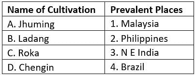
Match the following sets of pairs:

Q. Select the correct answer from the codes given below:

Practice Test: World Geography - 1 - Question 22

Consider the following statement/s regarding soil:

1. Humid climates in high latitude coniferous forests, mid – latitude tropical forests to low tropical forests and grasslands have Pedalfers type of Soil.

2. The arid, semi – arid and sub – humid zones in the world have Podcals group of soils.

3. Podcals are deficient in calcium and mineral salts while Pedalfers are calcium rich.

Q. Select the correct statement/s using the code given below:

Detailed Solution for Practice Test: World Geography - 1 - Question 22

Podcals are rich in calcium while Pedalfers are deficient in calcium and nutrients

Practice Test: World Geography - 1 - Question 23

Swathi, at local noon time looks down on the ground and sees her extended shadow in the Northern direction. Which of the below cities is Swathi definitely located?

Detailed Solution for Practice Test: World Geography - 1 - Question 23

Swathi is in Patna.

  • This questions has application of two concepts - one knowing the location of cities close to Tropic of cancer - which is a must for map work and second, the apparent migration of the Sun between the tropics.
  • Out of the four cities, Patna is the only city located above Tropic of cancer. This means that the Sun would never be directly overhead over Patna and would always be South of Patna, casting a shadow in the North direction. This is because Sun is directly overhead only between the tropic of cancer and tropic of capricorn.
  • All other cities are located south of Tropic of Cancer.
  • For all other cities, the Sun will cast a shadow either on the Southern side ( when Sun is directly overhead at some point North of the cities - say in Summer Solstice ) or on the Northern side.
  • Hence, it is only for Patna where the Sun will always cast shadow on the Northern side. 


Practice Test: World Geography - 1 - Question 24

Consider the following features of a climate:

1. It is experienced along the eastern coasts of tropical lands.

2. It's region receives steady rainfall due to Trade winds.

3. Rainfall is both orographic as well as conventional due to intense heating.

Q. Select the climatic region which has above mentioned characteristics.

Detailed Solution for Practice Test: World Geography - 1 - Question 24
  • Islands and coastal areas 10° to 20° north or south of the equator usually have a tropical marine climate. 
  • The ocean is the main influence in creating the tropical marine climate . There are two main seasons — the wet season and the dry season. The annual rainfall is 1000 to over 1500 mm. The temperature ranges from 25°C to 35°C. 
  • The trade winds blow all year round. The trade winds are moist, as they have passed over warm seas
180 videos|475 docs|198 tests
Information about Practice Test: World Geography - 1 Page
In this test you can find the Exam questions for Practice Test: World Geography - 1 solved & explained in the simplest way possible. Besides giving Questions and answers for Practice Test: World Geography - 1, EduRev gives you an ample number of Online tests for practice

Top Courses for UPSC

180 videos|475 docs|198 tests
Download as PDF

Top Courses for UPSC