UPSC Exam  >  UPSC Tests  >  Oxford Student ATLAS: Maps & Tests  >  Prelims Map Based Questions - 3 - UPSC MCQ

Prelims Map Based Questions - 3 - UPSC MCQ


Test Description

20 Questions MCQ Test Oxford Student ATLAS: Maps & Tests - Prelims Map Based Questions - 3

Prelims Map Based Questions - 3 for UPSC 2024 is part of Oxford Student ATLAS: Maps & Tests preparation. The Prelims Map Based Questions - 3 questions and answers have been prepared according to the UPSC exam syllabus.The Prelims Map Based Questions - 3 MCQs are made for UPSC 2024 Exam. Find important definitions, questions, notes, meanings, examples, exercises, MCQs and online tests for Prelims Map Based Questions - 3 below.
Solutions of Prelims Map Based Questions - 3 questions in English are available as part of our Oxford Student ATLAS: Maps & Tests for UPSC & Prelims Map Based Questions - 3 solutions in Hindi for Oxford Student ATLAS: Maps & Tests course. Download more important topics, notes, lectures and mock test series for UPSC Exam by signing up for free. Attempt Prelims Map Based Questions - 3 | 20 questions in 25 minutes | Mock test for UPSC preparation | Free important questions MCQ to study Oxford Student ATLAS: Maps & Tests for UPSC Exam | Download free PDF with solutions
Prelims Map Based Questions - 3 - Question 1

Consider the following facts:

  1. It is the highest navigable lake in the world.
  2. 60% of the lake is located in Peru whilst the remaining 40% belong to Bolivia
  3. It is a monomictic lake, with only 1 season of free circulation.

The above facts describe which of the following lakes?

Detailed Solution for Prelims Map Based Questions - 3 - Question 1

Lake Titicaca

  • Often referred to as the highest navigable lake in the world, Lake Titicaca is located at an altitude of 3,812 meters and it is the largest lake by volume in South America.
  • 60% of the lake is located in Peru (the western part), whilst the remaining 40% belong to Bolivia (the eastern end).
  • The lake is made up of two large basins which are connected by the Strait of Tiquina.
  • The Lake Titicaca Reserve was created in 1978 in aim of preserving the special fauna, fl ora and the unique countryside found here.
  • Monomictic lake: Monomictic lakes are holomictic (uniform temperature and density from top to bottom) lakes that mix from top to bottom during one mixing period each year. Monomictic lakes may be subdivided into cold and warm types. Lake Titicaca is a monomictic lake.
Prelims Map Based Questions - 3 - Question 2

Consider the following statements:

  1. This river fl ows through the territories of Brazil, Uruguay, and Argentina before it joins the Río de la Plata.
  2. It rises 1,800 meters above sea level in the Serra Peral of Brazil.
  3. This river or its tributaries forms the border between Argentina and Brazil, and between Brazil and Uruguay.

Which of the following rivers has been described in the above statements?

Detailed Solution for Prelims Map Based Questions - 3 - Question 2

River Uruguay has been described in the above sentences.

1 Crore+ students have signed up on EduRev. Have you? Download the App
Prelims Map Based Questions - 3 - Question 3

Consider the following statements regarding the Strait of Magellan:

  1. It is an artifi cial sea channel linking the Atlantic and Pacifi c oceans between the southern tip of South America and Tierra del Fuego Island.
  2. The traffi c through the strait is not affected by construction of Panama Canal.

Which of the above statement/s is/are notcorrect?

Detailed Solution for Prelims Map Based Questions - 3 - Question 3

It was an important sailing-ship route before the building of the Panama Canal (completed in 1914) shortened the Atlantic-Pacific  passage by several thousand miles.

Prelims Map Based Questions - 3 - Question 4

Which of the following pairs are correctly matched?

  1. Lauca National Park: Chile
  2. Iguazu National Park: Peru
  3. Chapada Diamantina National Park: Brazil Select

he correct option from the codes given below:

Detailed Solution for Prelims Map Based Questions - 3 - Question 4

Pair 2 is incorrectly matched: Iguazu National Park is in Argentina.

National Parks in South America

  • Lauca National Park is situated in northern Chile amid the Andes Mountains. Jutting snowcapped peaks make up most of the horizon, and there are also multiple volcanoes in the area. The park consists of marshy foothills populated by lots of local fauna. Many animals can be found gathering around the large lakes Chungará and Catacotani.
  • Iguazu National Park: First established in 1934, Iguazu National Park is one of the most well known national parks in South America. One of the most notable features of the park is the beautiful Iguazu Falls, which are enveloped in rainforest and became a UNESCO World Heritage Site in 1984.
Prelims Map Based Questions - 3 - Question 5

Which of the following countries of South America does not lie on the Tropic of Capricorn?

Detailed Solution for Prelims Map Based Questions - 3 - Question 5

The Tropic of Capricorn does not pass through Bolivia.

Prelims Map Based Questions - 3 - Question 6

Which of the following European countries does not open to Mediterranean Sea?

Detailed Solution for Prelims Map Based Questions - 3 - Question 6

Hungary is a landlocked country of Europe.

Prelims Map Based Questions - 3 - Question 7

Black sea is the border of which of the following European countries?

  1. Turkey
  2. Bulgaria
  3. Romania
  4. Ukraine
  5. Georgia

Which of the pairs given above are correctly matched?

Detailed Solution for Prelims Map Based Questions - 3 - Question 7

The Black Sea is the border of all the European countries listed above:

1. Turkey: The Black Sea lies to the north of Turkey, providing a natural border and a significant coastline.
2. Bulgaria: The eastern border of Bulgaria is the Black Sea, offering a coastline that attracts tourists to its beaches.
3. Romania: Romania shares its eastern border with the Black Sea, with important ports like Constanta located on its coast.
4. Ukraine: The southern border of Ukraine is the Black Sea, which provides the country with valuable access to maritime trade.
5. Georgia: Georgia, although located at the intersection of Eastern Europe and Western Asia, is considered part of Europe, and its western border is the Black Sea.

So, all the pairs given above are correctly matched.

Prelims Map Based Questions - 3 - Question 8

Consider the following pairs:

Which of the pairs given above are correctly matched?

Detailed Solution for Prelims Map Based Questions - 3 - Question 8

Pyrenees Mountains are part of Spain, France and Andorra

Prelims Map Based Questions - 3 - Question 9

Consider the following statements

  1. It is the longest river in Africa and its basin is popular for cotton cultivation since ancient time
  2. The river Nile has two major tributaries the White Nile and the Blue Nile of which the White Nile emerges from  Lake Victoria.
  3. Blue Nile emerges from Euthopian Highlands.

Select the correct answer using the code given below.

Detailed Solution for Prelims Map Based Questions - 3 - Question 9

Nile River

  • The Nile is a major north-fl owing river in northeastern Africa It is the longest river in Africa. Its basin has been popular for cotton cultivation since ancient times.
  • The river Nile has two major tributaries: the White Nile and the Blue Nile.
  • The White Nile is considered as the primary source of the Nile and it emerges from Lake Victoria.
  • The Blue Nile is considered as the source of most water in the Nile (80% nearly)  begins at Lake Tana in Ethiopia.
  • Countries from which River Nile fl ows Egypt, Sudan, South Sudan, Ethiopia, Uganda, Congo, Kenya, Tanzania, Rwanda, Burundi
Prelims Map Based Questions - 3 - Question 10

What is the correct sequence of occurrence of the following water bodies from south to north?

  1. Port Said
  2. Lake Timsah
  3. Port Tewfik
  4. Great Bitter lake

Select the correct answer using the code given below.

Detailed Solution for Prelims Map Based Questions - 3 - Question 10

sequence starting from south to north.

Prelims Map Based Questions - 3 - Question 11

The Andes Mountains are the longest continental mountain range in the world. It extends to which of the following South American country?

  1. Brazil
  2. Argentina
  3. Ecuador
  4. Venezuela

Select the correct option from the codes given below:

Detailed Solution for Prelims Map Based Questions - 3 - Question 11

Andes Mountain does not extends to Brazil.

Prelims Map Based Questions - 3 - Question 12

Consider the following:

  1. Canaima National Park
  2. Angel Falls
  3. Nazca Lines
  4. Lake Maracaibo

Which of the following is/are present in/a part of Venezuela?

Detailed Solution for Prelims Map Based Questions - 3 - Question 12

Nazca Lines are a part of Peru.

Prelims Map Based Questions - 3 - Question 13

Consider the following statements regarding the Drake Passage:

  1. The Drake Passage is the longest distance between Antarctica and other continents.
  2. This Passage is located between Cape Horn at the tip of South America and the Antarctic Peninsula.
  3. It is the narrowest stretch in the Southern Ocean and spans approximately 800 km.

Which of the above statement/s is/are correct?

Detailed Solution for Prelims Map Based Questions - 3 - Question 13

The Drake Passage is the shortest distance between Antarctica and other continents.

Prelims Map Based Questions - 3 - Question 14

Arrange the following capital cities of South American countries in North to South order:

  1. Brasilia
  2. Lima
  3. Montevideo
  4. Santiago

Select the correct option from the codes given below:

Detailed Solution for Prelims Map Based Questions - 3 - Question 14

Lima (Peru)-Brasilia (Brazil)-Santiago (Chile)-Montevideo (Uruguay)

Prelims Map Based Questions - 3 - Question 15

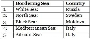
Consider the following pairs:

Which of the pairs given above are correctly matched?

Detailed Solution for Prelims Map Based Questions - 3 - Question 15
  • Statement 2 is incorrect: Sweden shares a boundary with Baltic Sea.
  • Statement 3 is incorrect: Moldova is a landlocked country.
Prelims Map Based Questions - 3 - Question 16

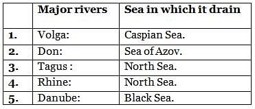
Consider the following pairs:

Which of the pairs given above are correctly matched?

Detailed Solution for Prelims Map Based Questions - 3 - Question 16

Statement 3 is incorrect. River Tagus drains into the Atlantic ocean.

Prelims Map Based Questions - 3 - Question 17

What is the correct sequence of occurrence of the following water bodies from south to north?

  1. Gulf of Bothnia
  2. Sea of Azov
  3. Adriatic Sea
  4. Ionian Sea

Select the correct answer using the code given below.

Detailed Solution for Prelims Map Based Questions - 3 - Question 17

Option d is the correct sequence starting from south to north.

Water Bodies of Europe

  • The Gulf of Bothnia is the northernmost part of the Baltic Sea. The Geographical Location is  between Finland’s west coast and Sweden’s east coast.
  • The Sea of Azov which is bounded by Ukraine and Russia in the Eastern Europe is connected to the Black Sea by the narrow Strait of Kerch. The Don and Kuban are the major rivers that fl ow into it.
  • The Adriatic Sea is the  northernmost part of the Mediterranean Sea. The countries with coasts on the Adriatic are Albania, Bosnia and Herzegovina, Croatia, Italy, Montenegro and Slovenia.
  • The Ionian Sea is an elongated bay of the Mediterranean Sea, which falls south of the Adriatic Sea and is bounded by Italy , Albania, and Greece.
Prelims Map Based Questions - 3 - Question 18

Which of the following countries  are the part of Alps Mountain ranges..

  1. Austria
  2. France
  3. Germany
  4. Monaco
  5. Spain

Select the correct answer using the code given below.

Detailed Solution for Prelims Map Based Questions - 3 - Question 18

Alps Mountain ranges

  • The Alps lying entirely in Europe are the highest and most extensive mountain range system It stretches approximately 1,200 kilometres across eight Alpine countries (from west to east): France, Switzerland, Monaco, Italy, Liechtenstein, Austria, Germany, and Slovenia.
  • The mountains were formed due to collision of  the African and Eurasian tectonic plates.
    The Extreme shortening caused by the event resulted in marine sedimentary rocks rising by thrusting and folding into high mountain peaks such as Mont Blanc and the Matterhorn.
  • Mont Blanc located in  the French–Italian border, is the highest mountain in the Alps at the height of  4,809 m (15,778 ft).
Prelims Map Based Questions - 3 - Question 19

Consider the following statements regarding the Congo River:

  1. It is the second longest river in Africa.
  2. It is also the world’s deepest recorded river.
  3. It crosses the equator twice during its course.

Select the correct answer using the code given below.

Prelims Map Based Questions - 3 - Question 20

What is the correct sequence of occurrence of the following Lakes  from north to south?

  1. Lake Turkana
  2. Lake Victoria
  3. Lake Tanganyika
  4. Lake Malawi

Select the correct answer using the code given below.

Detailed Solution for Prelims Map Based Questions - 3 - Question 20

The Great African lake

  • The African Great Lakes are a series of lakes which are part of the Rift Valley lakes and are located  in and around the East African Rift.  The major lakes are  Lake Victoria, Lake Tanganyika, and Lake Malawi.
  • Countries in the African Great Lakes region include Burundi, the Democratic Republic of the Congo, Ethiopia, Kenya, Malawi, Rwanda, Tanzania, and Uganda.
  • The African great lakes consist of seven lakes These are lake Victoria, Tanganyika, Malawi, Turkana, Albert, Kivu and Edward in order of size.
83 videos|105 docs|133 tests
Information about Prelims Map Based Questions - 3 Page
In this test you can find the Exam questions for Prelims Map Based Questions - 3 solved & explained in the simplest way possible. Besides giving Questions and answers for Prelims Map Based Questions - 3, EduRev gives you an ample number of Online tests for practice

Top Courses for UPSC

83 videos|105 docs|133 tests
Download as PDF

Top Courses for UPSC