SSC GD Constable Mock Test - 4 - SSC MTS / SSC GD MCQ
30 Questions MCQ Test - SSC GD Constable Mock Test - 4

Directions to Solve
In each of the following questions find out the alternative which will replace the question mark.
Question -
BCFG : HILM :: NORQ : ?

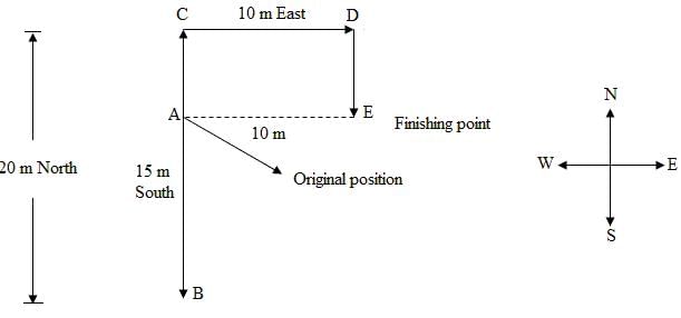
Mayna starts walking towards south. After walking a distance of 15 metres, she turns towards north. After walking another 20 metres, she turns towards east and walks another 10 metres. She then turns towards south and walks 5 metres more. How far and in which direction is Mayna from her original position?

Direction : Study the following question carefully and choose the right answer.
Q: If in a certain language, TRIANGLE is coded SQHZMFKD, then which word would be coded as DWZLOKD?
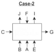
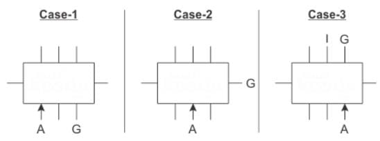
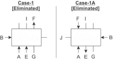
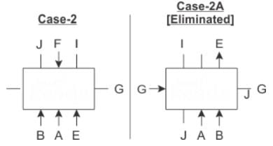
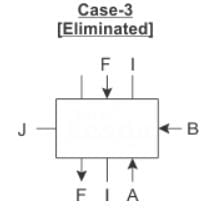
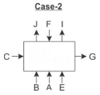
Directions: Read the following information carefully and answer the questions given beside.
Eight persons viz. A, B, C, E, F, G, I and J sit around a rectangular table such that three persons sit on each longer side and one person sits on each shorter side. Nobody sits at the corners. The persons whose name starts with vowel do not sit on the shorter side of the table. Three of them face away from centre while the rest five face towards the centre.
B, who faces centre sits second to the left of E. J is on the immediate right of F, who is at a gap of two persons from E. Neither C nor A face away from centre. The immediate neighbors of F face away from centre. G is second to the right of A. I is on the immediate left of F. I is neither adjacent to A nor to C. E is adjacent to G.
Q. Three of the following four are alike in a certain way and thus form a group. Which of the following does not belong to the group?
The average of eight numbers is 25, that of the first two is 20 and of the next three is 26. The sixth number is less than the seventh by 4, and less than the eighth by 6. The last number is
Three years ago , the average age of a family of 5 members was 17 years. Inspite of the birth of a child in the family, the present average age of the family remains the same. The present age of the child is
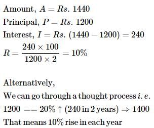
Find the rate of interest if the amount after 2 years of simple interest on a capital of Rs. 1200 is Rs. 1440.
Raju is twice as good as Vijay. Together, they finish the work in 14 days. In how many days can Vijay alone do the same work?
Find the 4-digit smallest number which when divided by 12, 15, 25, 30 leaves no remainder?
There are six bottles of same capacity that are filled with water. The quantities of water in all the bottles are in the ratio 1 : 2 : 3 : 4 : 5 : 6. The water in each of the bottles is poured into an empty jar whose capacity is half the total capacity of the six bottles. The jar is filled up completely. How many bottles were at least 70% filled with water initially?
Set A contains 10 consecutive numbers starting from x and set B contains 8 consecutive even numbers starting from y. The ratio of the average of set A elements to that of set B elements is 9 : 14. What is the ratio of x to y?
 = 9/14
A dishonest milkman mixes 20 litres of water with 80 litres of milk. After selling one-fourth of this mixture, he adds water to replenish the quantity that he had sold. What is the current proportion of water to milk?
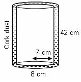
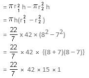
A cylindrical vessel of diameter 14 cm and height 42 cm is fixed symmetrically inside a similar vessel of diameter 16 cm and height 42 cm. If the total space between the two vessels is filled with cork dust for heat insulation purposes, then how many cubic centimetres of cork dust will be required?
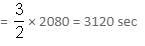
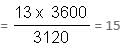
A tap drips at an average rate of 2 drops in 3 seconds. It takes 2080 drops of water to completely fill a hemispherical vessel of radius 8.3 cm. How many times can the vessel be filled in this manner in 13 hours?
During the Indian Freedom Struggle, who of the following raised an army called ‘Free Indian Legion’?
The major harmful gas emitted by automobile vehicles which causes air pollution is –
Which of the following trends were seen in the Indian economy after the 1991 economic reforms?
1. The growth rate steadily increased.
2. Agriculture and allied sector continuously show a positive growth rate.
3. Share of the public sector in total investment increased.
Which of the statements given above is/are correct?
With reference to the outcomes observed in the decade following the LPG reforms initiated in India in 1991, consider the following statements.
1. It led to rapid increase in FDI and forex reserves.
2. It led to increase in the GDP growth of the Indian economy.
3. It led to lower growth rate in manufacturing industries.
Which of the statements given above is/are correct?
Which organization collaborated with Indian Bank for Project WAVE, unveiling digital services?
What was the objective of the MoU signed between the National Anti-Doping Agency, India, and the South Asia Regional Anti-Doping Organization (SARADO)?
Who has been re-appointed as the Solicitor General of India?
DIRECTIONS: The following question contains an idiom and its usage in a sentence, followed by five possible meanings labelled A, B, C, D and E. Pick out the right meaning of the idiom in question and mark your answer accordingly.
Q.
Elbow grease.
He has reached this high stature through "elbow grease".
Although the initial setup of generators and a power grid by Edison and JP Morganwas rather costly, the electrification of lighting in lower Manhattan doubled work efficiency when the energy costs were cut in half.
Which one best expresses the given sentence in Passive/Active Voice?
Has someone made all the necessary arrangements?
Direction: The sentences given in the question, when properly sequenced, form a coherent paragraph. Each sentence is labeled with a letter. Choose the most logical order of sentences from the given choices to construct a coherent paragraph.
A. As people turned to farming, they began to live in fixed settlements, which became small towns.
B. Their labors bore fruit; surplus food freed some of the population from farming.
C. In about 5000 BC, farmers moved down into the fertile river valleys of Mesopotamia, and built dykes and ditches to irrigate the arid land.
D. The cultivation of plants, such as wheat and barley, and the domestication of animals, such as sheep, goats and cattle, began in the Near East in about 8500 BC.
Directions: Read the following passage carefully and answer the questions given beside.
Remote sensing and GIS are promising tools for handling spatial and temporal data and help in integrating them for successful planning of natural resources. It is the science of measuring the earth using sensors mounted on high-flying aircrafts or satellites. These sensors collect data in the form of images and provide insights for manipulating, analysing and visualising those images. Since natural resources are not uniformly distributed and are spatially varied, it is challenging to capture the correct picture. Management of natural resources calls for scientific tools for timely and accurate dissemination of information. In natural resource management, remote sensing and GIS are mainly used in the mapping process. These techniques are useful in management of land, soil, coastal, watershed, urban and many more.
In India, the agriculture sector alone sustains the livelihood of around 50 percent of the population. Therefore, an increase in crop productivity has been a major concern. Since, the scope for increasing area under agriculture is limited, advanced crop production forecasting is required for better policymaking. Indian Space Research Agency (ISRO) and Indian Council of Agricultural Research (ICAR) successful experiment-Agricultural Resource Inventory and Survey Experiment (ARISE) used aerial colour photographs to estimate crop acreage in many states of India. Other Important uses of remote sensing include crop identification, stress detection, and crop yield modelling, drought monitoring, land degradation mapping and more. Urbanisation is important and inevitable for development, but its proper planning and management is crucial for sustenance. One of the important features of GIS is multilayered mapping. This kind of mapping helps municipal corporations, town planning boards to build cities that are better organised. The information systems with socio-economic data overlaid upon satellite data makes urban planning cost-effective and accurate.
Coastal ecosystems have high ecological significance. GIS and remote sensing data are used to study coastal ecosystems and marine living resources which include habitats like mangroves, coral reefs and more. Apart from this, suspended shoreline dynamics can be studied and climatic changes leading to cyclones and sea level rise may be of special interest too. Geospatial data is effective in the analysis and determination of factors that affect the utilisation of these resources. The technologies provide a platform through which we can generate information that can be used to make sound decisions for sustainable development of the natural resources of India.
Q. Why, according to the passage, are GIS and remote sensing considered as promising tools?
I. They collect data in the form of graphs.
II. They provide scope for manipulating, analyzing and visualizing the images.
III. They disseminate data’s more accurately.
Directions: Read the following passage carefully and answer the questions given beside.
Remote sensing and GIS are promising tools for handling spatial and temporal data and help in integrating them for successful planning of natural resources. It is the science of measuring the earth using sensors mounted on high-flying aircrafts or satellites. These sensors collect data in the form of images and provide insights for manipulating, analysing and visualising those images. Since natural resources are not uniformly distributed and are spatially varied, it is challenging to capture the correct picture. Management of natural resources calls for scientific tools for timely and accurate dissemination of information. In natural resource management, remote sensing and GIS are mainly used in the mapping process. These techniques are useful in management of land, soil, coastal, watershed, urban and many more.
In India, the agriculture sector alone sustains the livelihood of around 50 percent of the population. Therefore, an increase in crop productivity has been a major concern. Since, the scope for increasing area under agriculture is limited, advanced crop production forecasting is required for better policymaking. Indian Space Research Agency (ISRO) and Indian Council of Agricultural Research (ICAR) successful experiment-Agricultural Resource Inventory and Survey Experiment (ARISE) used aerial colour photographs to estimate crop acreage in many states of India. Other Important uses of remote sensing include crop identification, stress detection, and crop yield modelling, drought monitoring, land degradation mapping and more. Urbanisation is important and inevitable for development, but its proper planning and management is crucial for sustenance. One of the important features of GIS is multilayered mapping. This kind of mapping helps municipal corporations, town planning boards to build cities that are better organised. The information systems with socio-economic data overlaid upon satellite data makes urban planning cost-effective and accurate.
Coastal ecosystems have high ecological significance. GIS and remote sensing data are used to study coastal ecosystems and marine living resources which include habitats like mangroves, coral reefs and more. Apart from this, suspended shoreline dynamics can be studied and climatic changes leading to cyclones and sea level rise may be of special interest too. Geospatial data is effective in the analysis and determination of factors that affect the utilisation of these resources. The technologies provide a platform through which we can generate information that can be used to make sound decisions for sustainable development of the natural resources of India.
Q. What can be the most appropriate title for the passage?
Important Questions for SSC GD Constable Mock Test - 4
SSC GD Constable Mock Test - 4 MCQs with Answers
Online Tests for SSC GD Constable Mock Test - 4
|
© EduRev
|
Education Revolution
|


|


within 7 days!