CISF Head Constable Mock Test - 9 - CISF Head Constable MCQ
30 Questions MCQ Test CISF Head Constable Mock Test Series 2025 - CISF Head Constable Mock Test - 9

Two matrices are shown in the figure below. Their rows and columns are labelled as (0,1,2,3,4) and (5,6,7,8,9) in the manner shown. Find the correct row-column pairs out of the following matrices that decode to the word - EASY

Direction: In each question below is given a statement followed by two conclusions numbered I and II. You have to assume everything in the statement to be true, then consider the two conclusions together and decide which of them logically follows beyond a reasonable doubt from the information given in the statement.
Statements: Vegetable prices are soaring in the market.
Conclusions:
- Vegetables are becoming a rare commodity.
- People cannot eat vegetables.

Direction: In each question below is given a statement followed by two conclusions numbered I and II. You have to assume everything in the statement to be true, then consider the two conclusions together and decide which of them logically follows beyond a reasonable doubt from the information given in the statement.
Statements: In a recent survey report, it has been stated that those who undertake physical exercise for at least half an hour a day are less prone to have any heart ailments.
Conclusions:
- Moderate level of physical exercise is necessary for leading a healthy life.
- All people who do desk-bound jobs definitely suffer from heart ailments.
Direction: In each question below is given a statement followed by two conclusions numbered I and II. You have to assume everything in the statement to be true, then consider the two conclusions together and decide which of them logically follows beyond a reasonable doubt from the information given in the statement.
Statements: This world is neither good nor evil; each man manufactures a world for himself.
Conclusions:
- Some people find this world quite good.
- Some people find this world quite bad.
Direction : Study the following question carefully and choose the right answer.
Q: If EARTH can be coded as ‘IUSBF’ how can GLOBE be coded?
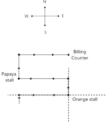
Directions: Study the following information carefully and answer the given questions.
Virat goes to Supermarket store to buy fruits. He enters the market, turns to his right, walks 7m and takes oranges. Then, he turns to his left, walks 3m and takes Peach. Again, he turns to his left, which is towards west, walks 7m and takes Papayas. Again, he turns to his right and looks at guavas, which 8m away from him. He takes guavas and moves to his right, walks 7m and stops at the counter for billing.
Q. In which direction is the Papaya stall located with respect to the Orange stall?
Study the following line graph and answer the questins.
Exports from Three Companies Over the Years (in Rs. crore)
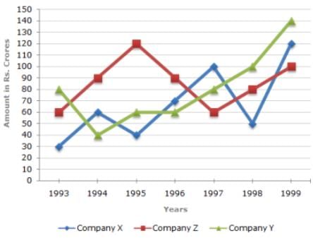
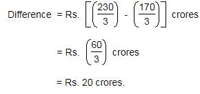
Q. What was the difference between the average exports of the three Companies in 1993 and the average exports in 1998?
Weights of two friends A and B are in the ratio of 1:2. A’s weight increases by 20% and the total weight of A and B together becomes 60 kg, with an increase of 30%. By what percent the weight of B increase?
The marked price of an article is 20% higher than the cost price. A discount of 20% is given on the marked price. In this transaction the seller
A sold a watch to B at a gain of 5% and B sold it to C at a gain of 4%. If C paid Rs. 1,092 for it, the price paid by A is
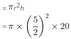
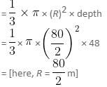
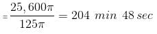
Find the approximate time taken to fill a chemical conical vessel, if the flow rate is 20 meters per minute from a cylindrical pipe whose diameter is 5 meters. Take diameter and depth of the conical vessel as 80 meters and 48 meters, respectively.
Direction: The following bar graph shows the number of articles (in thousands) sold in different years. Study this graph and answer the questions.
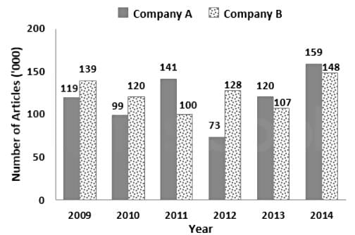
Q. If the number of articles sold by Company B in 2015 is 78% more than the difference between articles sold by Company A and Company B in 2014, then the approximate increase or decreases in the articles sold by Company B in 2015 from previous year is (approx.)
DIRECTIONS: The following question contains an idiom and its usage in a sentence, followed by four possible meanings labelled A, B, C, and D. Pick out the right meaning of the idiom in question and mark your answer accordingly.
Q.
Elbow grease.
He has reached this high stature through "elbow grease".
Although the initial setup of generators and a power grid by Edison and JP Morganwas rather costly, the electrification of lighting in lower Manhattan doubled work efficiency when the energy costs were cut in half.
Directions: In the given statements, a blank has been given. This needs to be filled up using the correct combination of words from the three options mentioned, so that the resulting statement is grammatically and contextually correct.
You should not _______________ the streets with rubbish; you should treat the public space the same way you would treat your own home.
I. garbage
II. loiter
III. litter
Directions: In the given statements, a blank has been given. This needs to be filled up using the correct combination of words from the three options mentioned, so that the resulting statement is grammatically and contextually correct.
In the ancient times, remaining alone was dangerous as _______________ animals could easily attack its solitary prey.
I. domesticated
II. wild
III. herbivorous
Direction: The sentences given in the question, when properly sequenced, form a coherent paragraph. Each sentence is labeled with a letter. Choose the most logical order of sentences from the given choices to construct a coherent paragraph.
A. As people turned to farming, they began to live in fixed settlements, which became small towns.
B. Their labors bore fruit; surplus food freed some of the population from farming.
C. In about 5000 BC, farmers moved down into the fertile river valleys of Mesopotamia, and built dykes and ditches to irrigate the arid land.
D. The cultivation of plants, such as wheat and barley, and the domestication of animals, such as sheep, goats and cattle, began in the Near East in about 8500 BC.
Directions: Read the following passage carefully and answer the questions given beside.
Remote sensing and GIS are promising tools for handling spatial and temporal data and help in integrating them for successful planning of natural resources. It is the science of measuring the earth using sensors mounted on high-flying aircrafts or satellites. These sensors collect data in the form of images and provide insights for manipulating, analysing and visualising those images. Since natural resources are not uniformly distributed and are spatially varied, it is challenging to capture the correct picture. Management of natural resources calls for scientific tools for timely and accurate dissemination of information. In natural resource management, remote sensing and GIS are mainly used in the mapping process. These techniques are useful in management of land, soil, coastal, watershed, urban and many more.
In India, the agriculture sector alone sustains the livelihood of around 50 percent of the population. Therefore, an increase in crop productivity has been a major concern. Since, the scope for increasing area under agriculture is limited, advanced crop production forecasting is required for better policymaking. Indian Space Research Agency (ISRO) and Indian Council of Agricultural Research (ICAR) successful experiment-Agricultural Resource Inventory and Survey Experiment (ARISE) used aerial colour photographs to estimate crop acreage in many states of India. Other Important uses of remote sensing include crop identification, stress detection, and crop yield modelling, drought monitoring, land degradation mapping and more. Urbanisation is important and inevitable for development, but its proper planning and management is crucial for sustenance. One of the important features of GIS is multilayered mapping. This kind of mapping helps municipal corporations, town planning boards to build cities that are better organised. The information systems with socio-economic data overlaid upon satellite data makes urban planning cost-effective and accurate.
Coastal ecosystems have high ecological significance. GIS and remote sensing data are used to study coastal ecosystems and marine living resources which include habitats like mangroves, coral reefs and more. Apart from this, suspended shoreline dynamics can be studied and climatic changes leading to cyclones and sea level rise may be of special interest too. Geospatial data is effective in the analysis and determination of factors that affect the utilisation of these resources. The technologies provide a platform through which we can generate information that can be used to make sound decisions for sustainable development of the natural resources of India.
Q. What is the tone of the author?
Directions: Read the following passage carefully and answer the questions given beside.
Remote sensing and GIS are promising tools for handling spatial and temporal data and help in integrating them for successful planning of natural resources. It is the science of measuring the earth using sensors mounted on high-flying aircrafts or satellites. These sensors collect data in the form of images and provide insights for manipulating, analysing and visualising those images. Since natural resources are not uniformly distributed and are spatially varied, it is challenging to capture the correct picture. Management of natural resources calls for scientific tools for timely and accurate dissemination of information. In natural resource management, remote sensing and GIS are mainly used in the mapping process. These techniques are useful in management of land, soil, coastal, watershed, urban and many more.
In India, the agriculture sector alone sustains the livelihood of around 50 percent of the population. Therefore, an increase in crop productivity has been a major concern. Since, the scope for increasing area under agriculture is limited, advanced crop production forecasting is required for better policymaking. Indian Space Research Agency (ISRO) and Indian Council of Agricultural Research (ICAR) successful experiment-Agricultural Resource Inventory and Survey Experiment (ARISE) used aerial colour photographs to estimate crop acreage in many states of India. Other Important uses of remote sensing include crop identification, stress detection, and crop yield modelling, drought monitoring, land degradation mapping and more. Urbanisation is important and inevitable for development, but its proper planning and management is crucial for sustenance. One of the important features of GIS is multilayered mapping. This kind of mapping helps municipal corporations, town planning boards to build cities that are better organised. The information systems with socio-economic data overlaid upon satellite data makes urban planning cost-effective and accurate.
Coastal ecosystems have high ecological significance. GIS and remote sensing data are used to study coastal ecosystems and marine living resources which include habitats like mangroves, coral reefs and more. Apart from this, suspended shoreline dynamics can be studied and climatic changes leading to cyclones and sea level rise may be of special interest too. Geospatial data is effective in the analysis and determination of factors that affect the utilisation of these resources. The technologies provide a platform through which we can generate information that can be used to make sound decisions for sustainable development of the natural resources of India.
Q. What can be the most appropriate title for the passage?
Which physical quantity is measured in ‘siemens’?
Which one of the following is a viral disease in man?
Potassium Permanganate is used for purifying drinking water, because -
Which of the following states is not included in Capital Region Planning Council?
Which organization did Edgars Rinkevics vow to support and uphold during his inauguration speech as Latvia's president?
Where is the third Trade and Investment Working Group Meeting taking place as part of India's G20 presidency?
What is the purpose of the tamper-proof device developed by IIT-Kharagpur?
What was special about Lakshya Sen's victory in the Canada Open?
Who has been appointed as the new chairperson of the International Financial Services Centres Authority (IFSC
Important Questions for CISF Head Constable Mock Test - 9
CISF Head Constable Mock Test - 9 MCQs with Answers
Online Tests for CISF Head Constable Mock Test - 9 CISF Head Constable Mock Test Series 2025
|
© EduRev
|
Education Revolution
|


|


