UPSC Exam  >  UPSC Tests  >  Geography for UPSC CSE  >  Test: Indian Drainage System - UPSC MCQ

Test: Indian Drainage System - UPSC MCQ


Test Description

30 Questions MCQ Test Geography for UPSC CSE - Test: Indian Drainage System

Test: Indian Drainage System for UPSC 2024 is part of Geography for UPSC CSE preparation. The Test: Indian Drainage System questions and answers have been prepared according to the UPSC exam syllabus.The Test: Indian Drainage System MCQs are made for UPSC 2024 Exam. Find important definitions, questions, notes, meanings, examples, exercises, MCQs and online tests for Test: Indian Drainage System below.
Solutions of Test: Indian Drainage System questions in English are available as part of our Geography for UPSC CSE for UPSC & Test: Indian Drainage System solutions in Hindi for Geography for UPSC CSE course. Download more important topics, notes, lectures and mock test series for UPSC Exam by signing up for free. Attempt Test: Indian Drainage System | 30 questions in 35 minutes | Mock test for UPSC preparation | Free important questions MCQ to study Geography for UPSC CSE for UPSC Exam | Download free PDF with solutions
Test: Indian Drainage System - Question 1

Which of the following rivers flows through a ‘rift’ valley?

Detailed Solution for Test: Indian Drainage System - Question 1
Narmada River flows through a rift valley.

Test: Indian Drainage System - Question 2

Which of the following is/are West flowing river(s) of India?

1. Mahanadi

2. Krishna

3. Narmada

4. Kavery

Select the correct answer using the codes given below

Detailed Solution for Test: Indian Drainage System - Question 2
  • The Narmada is one of the most famous Rivers of India. It creates the conventional border between South India and North India.

  • The river runs to the west for a span of 1,312 km (815.2 miles) before flowing through the Gulf of Khambhat (Cambay) into the Arabian Sea, at a distance of 18.6 miles or 30 km west of the Bharuch city in Gujarat.

  • Also known as Rewa. River in Central India. Similar to the Mahi River and the Tapti River, the Narmada River is a river flowing from east to west.

1 Crore+ students have signed up on EduRev. Have you? Download the App
Test: Indian Drainage System - Question 3

Which of the following best explain why the lower course of a river is sometimes choked with sediments?

1. The valley of a river is widest in its lower course.

2. The velocity of a river in its lower course is low.

3. The delta sometimes develops in a river’s lower course.

4. Much of the river water is drawn for irrigation in the lower course.

Select the correct answer using the codes given below

Detailed Solution for Test: Indian Drainage System - Question 3
The river is choked because the valley of a river is widest in its lower course and the velocity of a river in its lower course is low.

Test: Indian Drainage System - Question 4

Which of the following rivers flows from south to north?

Detailed Solution for Test: Indian Drainage System - Question 4
  • The Son originates near Amarkantak in Madhya Pradesh, just east of the headwater of the Narmada River, and flows north-northwest through Madhya Pradesh state before turning sharply eastward where it encounters the southwest-northeast- running Kaimur Range.

  • The Son river at 784 kilometres (487 mi) long, is one of the largest rivers of India. Its chief tributaries are the Rihand and the North Koel.

Test: Indian Drainage System - Question 5

Which one of the following rivers in India has been declared as the National River?

Detailed Solution for Test: Indian Drainage System - Question 5
  • The Ganges is a trans-boundary river of India and Bangladesh. The 2,525 km (1,569 mi) river rises in the western Himalayas in the Indian state of Uttarakhand and flows south and east through the Gangetic Plain of North India into Bangladesh, where it empties into the Bay of Bengal. It is the third-largest river in the World by discharge.

Test: Indian Drainage System - Question 6

Which of the following rivers is not the tributary of Yamuna?

Detailed Solution for Test: Indian Drainage System - Question 6

Answer:
Explanation:
The river that is not a tributary of Yamuna is the Gandak River.
Details:
The following rivers are tributaries of Yamuna:
- Chambal River: It originates from the Vindhya Range in Madhya Pradesh and flows through Rajasthan and Uttar Pradesh before joining the Yamuna River.
- Betwa River: It is a major river in central India and flows through the states of Madhya Pradesh and Uttar Pradesh before merging with the Yamuna River.
- Ken River: It is a tributary of the Yamuna River and flows through the states of Madhya Pradesh and Uttar Pradesh.
However, the Gandak River is not a tributary of the Yamuna. It is a major river in Nepal and a left-bank tributary of the Ganges in India. It is also known as the Krishna Gandaki in Nepal. The Gandak River originates in the high Himalayas and flows through Nepal and the Indian states of Uttarakhand, Uttar Pradesh, and Bihar before joining the Ganges River.

Test: Indian Drainage System - Question 7

Which one of the following rivers of India does not make a delta?

Detailed Solution for Test: Indian Drainage System - Question 7

The Narmada, also called the Rewa, is a river in central India and the fifth-longest river in the Indian subcontinent. It is the third-longest river that flows entirely within India, after the Godavari and the Krishna.


Test: Indian Drainage System - Question 8

An important river of the Indian desert is?

Detailed Solution for Test: Indian Drainage System - Question 8
The Luni is a river of western Rajasthan state, India. It originates in the Pushkar valley of the Aravalli Range, near Ajmer and ends in the marshy lands of Rann of Kutch in Gujarat, after travelling a distance of 495 km.

Test: Indian Drainage System - Question 9

Which river is not in existence at present?

Detailed Solution for Test: Indian Drainage System - Question 9
  • Saraswati River refers to a river that was a distributary of the Bhagirathi and is now no more there but was active till around the 16th century AD.

  • The course and condition of the Saraswati have played an important role in the development and decline of river port towns in Bengal. Initially, the major port town was Tamralipta, after its decline Saptagram rose and declined, and finally, Kolkata came up.

Test: Indian Drainage System - Question 10

Which of the major rivers of India does not form a delta?

Detailed Solution for Test: Indian Drainage System - Question 10

Conditions for delta formation by a river:

  • The river must have a gentle gradient in its lower course

  • The river must carry a large amount of sediments along with it

  • The coastal plains or area where the mouth of river lies should be wide

Though Narmada originates far from the Western Ghats and empties into the Arabian Sea, the river flows through a rift valley at a steep gradient which increases its speed. Also, the western coastal plains are less wider than that required for delta formation by Narmada.

Test: Indian Drainage System - Question 11

Ganga is a result of the confluence of rivers –––

Detailed Solution for Test: Indian Drainage System - Question 11
Bhagirathi and Alaknanda rivers meet at DevPrayag and downstream flow as the Ganges.

Test: Indian Drainage System - Question 12

Match List-I with List-II and select the correct answer using the

codes given below:
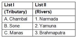
Which of the pairs given above is/are correctly matched?

Detailed Solution for Test: Indian Drainage System - Question 12
  • The Manas River is a major tributary of the Brahmaputra River flowing through Assam. It is named after “Goddess Manasa”, the serpent God in Hindu mythology.

  •  

    The Manas River is a trans-boundary river in the Himalayan foothills between southern Bhutan and India.


Test: Indian Drainage System - Question 13

Which one among the following is the correct sequence of the rivers from north to south?

Detailed Solution for Test: Indian Drainage System - Question 13
Correct sequence of the rivers from north to south:
To determine the correct sequence of the rivers from north to south, we need to analyze the given options and identify the order in which the rivers are arranged. Let's examine each option:
Option A: Damodar-Brahmani-Mahanadi-Tungabhadra
This option suggests that the Damodar river is the northernmost, followed by Brahmani, Mahanadi, and Tungabhadra.
Option B: Damodar-Mahanadi-Brahmani-Tungabhadra
This option suggests that the Damodar river is the northernmost, followed by Mahanadi, Brahmani, and Tungabhadra.
Option C: Brahmani-Tungabhadra-Damodar-Mahanadi
This option suggests that the Brahmani river is the northernmost, followed by Tungabhadra, Damodar, and Mahanadi.
Option D: Damodar-Brahmani-Tungabhadra-Mahanadi
This option suggests that the Damodar river is the northernmost, followed by Brahmani, Tungabhadra, and Mahanadi.
Conclusion:
By comparing the given options and considering the direction from north to south, we can determine that Option A: Damodar-Brahmani-Mahanadi-Tungabhadra is the correct sequence of the rivers.
Test: Indian Drainage System - Question 14

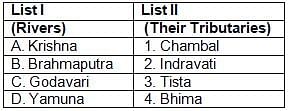
Match List-I with List-II and select the correct answer from the

codes given below:
Detailed Solution for Test: Indian Drainage System - Question 14

Correct option is B. 

Test: Indian Drainage System - Question 15

The reservoir GB Pant Sagar is located on which river?

Detailed Solution for Test: Indian Drainage System - Question 15
Govind Ballabh Pant Sagar is on the Rihand River

Test: Indian Drainage System - Question 16

Which one of the following rivers flows into the Arabian Sea?

Detailed Solution for Test: Indian Drainage System - Question 16
Narmada flows into the Gulf of Khambhat (Arabian Sea).

Test: Indian Drainage System - Question 17

Deltas are common in India for the East-flowing river systems, whereas they are nearly absent on the West coast because West-flowing rivers

Detailed Solution for Test: Indian Drainage System - Question 17
  • Most of the Western flowing rivers travel lesser distance away to Western coast through hard rocks and over a higher gradient, they couldn’t collect large amounts of Slit and flow with very high speed compared to East flowing rivers.

  • Eastern rivers flow through broken hills and mountain ranges. So, they widened and flowed with lesser velocity before entering the sea. So, they deposit sediments and silt before entering into the sea and can form a Delta.

Test: Indian Drainage System - Question 18

Which of the following three rivers of the peninsula India have the Amarkantak region as their source?

Detailed Solution for Test: Indian Drainage System - Question 18
Son, Mahanadi and Narmada rivers originate from Amarkantak region.

Test: Indian Drainage System - Question 19

Arrange the following tributaries of river Indus from North to South :

1. Chenab

2. Jhelum

3. Ravi

4. Sutlej

Select the correct answer using the code given below :

Detailed Solution for Test: Indian Drainage System - Question 19


To arrange the tributaries of the Indus River from North to South, we need to identify their positions and order them accordingly. Let's analyze the given options:
1. Chenab: The Chenab River is located in the north of the other tributaries mentioned.
2. Jhelum: The Jhelum River is located in the south of the Chenab River.
3. Ravi: The Ravi River is located in the south of the Jhelum River.
4. Sutlej: The Sutlej River is located in the south of the Ravi River.
Now, let's arrange the tributaries from North to South:
1. Chenab
2. Jhelum
3. Ravi
4. Sutlej
Therefore, the correct arrangement is option D: 2-1-3-4.
Hence, the correct answer is option D.
Test: Indian Drainage System - Question 20

Which one of the following pairs of a river and its tributary is not correctly matched?

Detailed Solution for Test: Indian Drainage System - Question 20
Amaravati River is the longest tributary of the Kaveri river.

Test: Indian Drainage System - Question 21

The Amarkantak Hills is the source of which of the following rivers?

1. Narmada

2. Mahanadi

3. Tapti

4. Son

Select the correct answer using the code given below:

Detailed Solution for Test: Indian Drainage System - Question 21

Explanation:

Amarkantak Hills:
- The Amarkantak Hills are a range of mountains in Madhya Pradesh, India.
- These hills are the origin of several important rivers in India.

Rivers originating from Amarkantak Hills:
- Narmada River: The Narmada River originates from the Amarkantak Hills and flows through central India before draining into the Arabian Sea.
- Mahanadi River: The Mahanadi River also originates from the Amarkantak Hills and flows through the states of Chhattisgarh and Odisha before draining into the Bay of Bengal.
- Son River: The Son River, a tributary of the Ganges, also originates from the Amarkantak Hills and flows through the states of Madhya Pradesh, Jharkhand, and Bihar.

Correct Answer:
- Therefore, the correct answer is option D: 1, 2, and 4 only.

Test: Indian Drainage System - Question 22

Which of the following rivers has the largest catchment area?

Detailed Solution for Test: Indian Drainage System - Question 22
The river Godavari arises from the Nasik district of Maharashtra. It has a length of 1465 km and after it, Krishna, Mahanadi, Narmada and Kaveri are the largest rivers of peninsular India.

Test: Indian Drainage System - Question 23

Which one of the following waterfalls in India has the most height?

Detailed Solution for Test: Indian Drainage System - Question 23

The Kunchikal falls is the highest waterfalls in India and also the second highest in Asia. The height of the waterfall is 1,493 ft is located near Agumbe in Shimoga district of Karnataka.

Test: Indian Drainage System - Question 24

Which of these west-flowing rivers flow between two mountain ranges?

Detailed Solution for Test: Indian Drainage System - Question 24
It is one of only three major rivers in peninsular India that run from east to west (longest west flowing river), along with the Tapti River and the Mahi River. It is one of the rivers in India that flows in a rift valley, flowing west between the Satpura and Vindhya ranges.

Test: Indian Drainage System - Question 25

Gandak river is associated with one of the following river systems—

Detailed Solution for Test: Indian Drainage System - Question 25
The Gandak River, river in central Nepal and northern India is a left-bank tributary of the Ganges in India.

Test: Indian Drainage System - Question 26

Which one of the following is not a tributary of river Alaknanda?

Detailed Solution for Test: Indian Drainage System - Question 26
Bhilangana is not a tributary of Alaknanda. Bhilangana River is a Himalayan river in Uttarakhand, India which is a major tributary of the Bhagirathi River.

Test: Indian Drainage System - Question 27

Which of the following pairs of waterfalls — the river is not properly matched?

Detailed Solution for Test: Indian Drainage System - Question 27
The Lodh Falls is a waterfall in a mid forest in Latehar district. It is located on the Burha river.

Test: Indian Drainage System - Question 28

Rajarappa is situated on the confluence of which rivers?

Detailed Solution for Test: Indian Drainage System - Question 28
Rajrappa is a waterfall and a pilgrimage Centre in Ramgarh, Jharkhand. It is situated on the confluence of Damodar – Behera rivers.
Test: Indian Drainage System - Question 29

Consider the following tributaries of river Brahmaputra :

1. Lohit

2. Tista

3. Subansiri

4. Sankosh

Arrange the above rivers from west to east:

Detailed Solution for Test: Indian Drainage System - Question 29

Tista, Sankosh, Subansiri and Lohit are the tributaries of river Brahmaputra

Test: Indian Drainage System - Question 30

Which one of the following does not belong to Himalayan rivers?

Detailed Solution for Test: Indian Drainage System - Question 30

Indus, Ganga, Brahmaputra, Satluj, Alaknanda, Gandak, Kosi etc are Himalayan rivers

180 videos|475 docs|198 tests
Information about Test: Indian Drainage System Page
In this test you can find the Exam questions for Test: Indian Drainage System solved & explained in the simplest way possible. Besides giving Questions and answers for Test: Indian Drainage System, EduRev gives you an ample number of Online tests for practice

Top Courses for UPSC

180 videos|475 docs|198 tests
Download as PDF

Top Courses for UPSC