KTET Exam  >  KTET Tests  >  Kerala SET Mock Test Series 2024  >  Kerala SET Paper 2 Mock Test - 3 (Geography) - KTET MCQ

Kerala SET Paper 2 Mock Test - 3 (Geography) - KTET MCQ


Test Description

30 Questions MCQ Test Kerala SET Mock Test Series 2024 - Kerala SET Paper 2 Mock Test - 3 (Geography)

Kerala SET Paper 2 Mock Test - 3 (Geography) for KTET 2024 is part of Kerala SET Mock Test Series 2024 preparation. The Kerala SET Paper 2 Mock Test - 3 (Geography) questions and answers have been prepared according to the KTET exam syllabus.The Kerala SET Paper 2 Mock Test - 3 (Geography) MCQs are made for KTET 2024 Exam. Find important definitions, questions, notes, meanings, examples, exercises, MCQs and online tests for Kerala SET Paper 2 Mock Test - 3 (Geography) below.
Solutions of Kerala SET Paper 2 Mock Test - 3 (Geography) questions in English are available as part of our Kerala SET Mock Test Series 2024 for KTET & Kerala SET Paper 2 Mock Test - 3 (Geography) solutions in Hindi for Kerala SET Mock Test Series 2024 course. Download more important topics, notes, lectures and mock test series for KTET Exam by signing up for free. Attempt Kerala SET Paper 2 Mock Test - 3 (Geography) | 120 questions in 120 minutes | Mock test for KTET preparation | Free important questions MCQ to study Kerala SET Mock Test Series 2024 for KTET Exam | Download free PDF with solutions
Kerala SET Paper 2 Mock Test - 3 (Geography) - Question 1

Given below are two statements, one labeled as Assertion (A) and the other labeled as Reason (R):

Assertion (A): Pragmatism is a modified form of functionalism

Reason (R): Applied geography recognizes geographical space as a combination of knowledge and error.

In the context of the above two statements, which of the following is correct?

Detailed Solution for Kerala SET Paper 2 Mock Test - 3 (Geography) - Question 1

The correct answer is (A) is wrong, but (R) is correct.
Key PointsAssertion (A): Pragmatism is a modified form of functionalism

  • Pragmatism and functionalism are two philosophies William James used to further his understanding of the world around him. James posited the pragmatic theory of truth and used.
  • This philosophy to define and re-define ideas, filtering answers to his questions through this theory. Most of his findings, theories, and inquiries were viewed according to his pragmatic theory of truth.
  • William James founded the school of functionalism. This school of thought in psychology was developed in direct response to the school of structuralism and the work of Wilhelm Wundt. Wundt criticized functionalism as nothing more than literature, and James criticized structuralism as “all school and no thought.”

Hence, Assertation is Incorrect

Reason (R): Applied geography recognizes geographical space as a combination of knowledge and error.

The elements of pragmatic geography can be identified as under: (i) Geographic space is a composite of knowledge and error. (ii) Geographic space is changeable as our knowledge of it changes and the scale of measurement becomes more refined.

Hence, The reason is correct

Kerala SET Paper 2 Mock Test - 3 (Geography) - Question 2

Which of the following is NOT a component of Green Revolution? Choose your answer from the code given below:

a) Guaranteed employment

b) High Yielding Variety(HYI) of seeds

c) Rural electrification

d) No Poverty

e) Agricultural Universities

f) Land Reforms

Detailed Solution for Kerala SET Paper 2 Mock Test - 3 (Geography) - Question 2

The high Yielding Variety(HYV) of seeds and agricultural universities are ways of optimizing agricultural output through advanced technology. It is a very important component of Green Revolution. Land Reforms such as abolishment of Raitwari and Zamindari system led to improvement in agricultural sector and was important for Green Revolution. The rural electrification guaranteed irrigation for agriculture and thus a part of Green Revolution. No Poverty as well as Employment guarantee, on the other hand , were not the components of Green Revolution.

Thus, the correct answer is C.

1 Crore+ students have signed up on EduRev. Have you? Download the App
Kerala SET Paper 2 Mock Test - 3 (Geography) - Question 3

Which of the following is/are included in National Population Policy (NPP) 2000?

1. Promoting delayed marriage for girl

2. Free and compulsory school education up to 14 years of age

3. Protection from unwanted pregnancies

4. Providing nutritional services

Select the correct answer from the codes given below.

Detailed Solution for Kerala SET Paper 2 Mock Test - 3 (Geography) - Question 3

The correct answer is 1, 2, 3 and 4.

  • The Family Welfare Programme has sought to promote responsible and planned parenthood on a voluntary basis.
  • The National Population Policy (NPP) 2000 is a culmination of years of planned efforts.

Key Points

National Population Policy 2000 provides a policy framework for imparting:

  1. Free and compulsory school education up to 14 years of age,
  2. Reducing infant mortality rate to below 30 per 1000 live births,
  3. Achieving universal immunisation of children against all vaccine-preventable diseases,
  4. Promoting delayed marriage for girls,
  5. Making family welfare a people-centred programme

Policy for adolescents: NPP 2000 identified adolescents as one of the major sections of the population that need greater attention. Its emphasis on the following issues,

  1. Nutritional requirements
  2. Protection from unwanted pregnancies
  3. Protection from sexually transmitted diseases (STDs).
  4. Programs that aim towards encouraging delayed marriage and child-bearing
  5. Education of adolescents about the risks of unprotected sex,
  6. Making contraceptive services accessible and affordable,
  7. Providing food supplements, nutritional services,
  8. Strengthening legal measures to prevent child marriage.

People are the nation’s most valuable resource. A well-educated healthy population provides potential power.

Kerala SET Paper 2 Mock Test - 3 (Geography) - Question 4

Sargasso sea is characterised by

Detailed Solution for Kerala SET Paper 2 Mock Test - 3 (Geography) - Question 4

The correct answer is typical marine vegetation.

Key Points

  • Sargasso Sea:
    • While there are many different types of algae found floating in the ocean all around world, the Sargasso Sea is unique in that it harbors species of sargassum that are 'holopelagic' — this means that the algae not only freely floats around the ocean, but it reproduces vegetatively on the high seas.
    • The mean annual temperature is 28 degrees C.
    • Sea is covered with rootless seaweeds which obstruct navigation.
    • It is a spawning site for threatened and endangered Eels, as well as white Marlin, porbeagle Shark, and Dolphinfish.
    • Hence, Option 4 is correct.

Kerala SET Paper 2 Mock Test - 3 (Geography) - Question 5
Who is universally accepted as the founder of human geography?
Detailed Solution for Kerala SET Paper 2 Mock Test - 3 (Geography) - Question 5

The correct answer is Friederich Ratzel.

Important Points

  • Friederich Ratzel is universally accepted as the founder of human geography because of his pioneering work in the field during the late 19th century.
  • He was one of the first geographers to take a holistic and interdisciplinary approach to the study of human society and its relationship with the environment.
  • He wrote the first systematic treatise on the field, "Anthropogeographie," in 1882, which laid out many of the key concepts and themes that are still central to human geography today.

Key PointsSome of his main contributions to the field of human geography include:

  • Anthropogeography: Ratzel introduced the term "Anthropogeography" to describe the study of human society and its relationship with the environment.

  • Lebensraum: Ratzel developed the concept of "lebensraum" which refers to the space where people live and develop

Organic Analogy:

  • Ratzel used the organic analogy to describe the relationship between human society and the environment.
  • He compared the growth and development of human society to that of an organism, arguing that just as an organism adapts to its environment, human society also adapts to its surroundings.

Kerala SET Paper 2 Mock Test - 3 (Geography) - Question 6
_______ Ocean is also known as the Southern Ocean.
Detailed Solution for Kerala SET Paper 2 Mock Test - 3 (Geography) - Question 6

The correct answer is Antarctic.

The Antarctic Ocean is also known as the Southern Ocean.

Antarctic Ocean:

  • The Antarctic Ocean is also known as the Austral Ocean.
  • It is located in the southernmost region of the world.
  • The Antarctic Ocean is smaller than Pacific, Atlantic and the Indian Ocean but larger than Arctic ocean. 

Pacific Ocean:

  • It is also known as the Peaceful Sea.
  • It is located from the Arctic Ocean to Antarctic Ocean.
  • It is the largest and deepest ocean in the world.

Atlantic Ocean:

  • It is the second-largest ocean in the world.
  • It separates the eastern and western countries.

Indian Ocean:

  • It is also known as Hindu Ocean or Sindhu Mahasagara.
  • It is located to the south of India.
  • It is the third-largest Ocean in the world.
Kerala SET Paper 2 Mock Test - 3 (Geography) - Question 7
Select the example of Active sensor in Remote sensing, from the following sensors.
Detailed Solution for Kerala SET Paper 2 Mock Test - 3 (Geography) - Question 7

Concepts:

Remote sensing is the art and science of obtaining information about an object without physical contact with that object.

The passive sensor responds to physical stimuli. Light, heat, vibrations are detected from passive sensors as they occur in the environment. Examples are Electro-optical sensors, the Television cameras. Return Beam Vidicon.

Active sensors work along with transducers that create the stimuli to be detected and measured that interaction of those stimuli with the environment. Examples are Sonar or LIDAR systems, Laser scanners, etc. 

Kerala SET Paper 2 Mock Test - 3 (Geography) - Question 8
A nautical mile is equal to ______.
Detailed Solution for Kerala SET Paper 2 Mock Test - 3 (Geography) - Question 8
  • A nautical mile is a unit of measurement used for measuring both marine navigation and air.
  • It is also used for defining territorial waters and which can be defined as one minute (1/60 of a degree) of latitude along any line of longitude.
  • As per the international standard, a nautical mile is equal to 1852 meters.
  • There are internationally accepted various abbreviations used for the nautical mile by different organizations and agencies are M, NM, nm, nmi and nq.
Kerala SET Paper 2 Mock Test - 3 (Geography) - Question 9

Given below are two statements. One is labeled as Assertion (A) and the other is labeled as Reason (R):

Assertion (A): The small regional units in rural France which are having unique agricultural termed as pays by Blache.

Reason (R): Blache strongly supported environmental determinism and criticize the concept of possibilism.

Select the correct answer from the options given below:

Detailed Solution for Kerala SET Paper 2 Mock Test - 3 (Geography) - Question 9

Correct Answer: (A) is true, but (R) is false.

Key Points

Assertion (A): The small regional units in rural France which are having unique agricultural termed as pays by Blache.

  • In France, the discipline had roots in history and mapping.
  • The first major practitioner was Paul Vidal de la Blache, who had trained as a geographer and was appointed to the Sorbonne in 1898, where he maintained close links with the Annales school of historians.
  • Vidal focused on defining and describing regions, or what he called pays—relatively small homogeneous areas—whose distinctive genres de vie (“modes of life”) resulted from the interactions of people with their physical milieux.
  • Unlike some of his German contemporaries, notably Ratzel, he did not see those interactions as predominantly determined by the physical environment.
  • Instead, he promoted what became known as possibilism, where the environment offers a range of options, and people choose how to modify nature according to their cultural and technological inheritances.
  • As the contemporary historian, Lucien Febvre put it, “nowhere necessities…everywhere possibilities.” Vidal’s major contributions were his Tableau de la géographie de la France (1903; “Outline of the Geography of France”), an introduction to the multivolume Histoire de la France, and the 15-volume Géographie universelle (1927–48). 

Hence, the assertion is correct.

Reason (R): Blache strongly supported environmental determinism and criticize the concept of possibilism.

  • Environmental possibilism was set forth by the French geographer Paul Vidal de la Blanche who stated that the environment sets limitations for cultural development, but it does not wholly define culture.
  • Culture is instead defined by the opportunities and decisions that humans make in response to dealing with such limitations.
  • Alfred Hettner, a German Geographer known for his concept of chorology (the study of places and regions) is most widely considered as one of the pioneers of a school of thought of Possibilism.
  • However, even earlier than him, French geographer Paul Vidal de la Blache, became the first active advocate of possibilism.

Hence, the reason is incorrect.

​Therefore (A) is true, but (R) is false.

Kerala SET Paper 2 Mock Test - 3 (Geography) - Question 10
Consider the following statements-

i. T.C Chamberlin advanced the carbon dioxide theory.

ii. Carbon dioxide and water vapour produces greenhouse effect.

Choose the correct answer:

Detailed Solution for Kerala SET Paper 2 Mock Test - 3 (Geography) - Question 10

The carbon dioxide theory was advanced by T.C Chamberlin in the last decade of 19th century. According to this theory variations in the carbon dioxide content of the atmosphere play dominant role in causing worldwide climate change. Carbon dioxide and water vapour content of the atmosphere being the most important heat absorbers produce what is called greenhouse effect.

Thus, the Correct answer is C.

Kerala SET Paper 2 Mock Test - 3 (Geography) - Question 11

With reference to Land breeze, Consider the following:

1. It occurs during the night.

2. The air flows from the high pressure over the sea to the low pressure over the land.

3. Land breezes are more prevalent during the winter seasons.

Which of the statements given above is/are correct?

Detailed Solution for Kerala SET Paper 2 Mock Test - 3 (Geography) - Question 11

The correct answer is 1 and 3 only.

Key Points

Land Breeze:

  • This process takes place for the duration of the night. Hence statement 1 is correct.
  • Both, the land and the sea start cooling down when the sunsets.
  • As the heat capacity of the land is different from the sea it cools down quicker.
  • Thus, a low-pressure develops over the sea as the temperature above it is higher when compared to the land.
  • Due to this, the air flows from the land to the sea which is termed the land breeze. Hence statement 2 is not correct.
  • Land breezes can occur at any time of year but are more prevalent during the fall and winter seasons when water temperatures are still fairly warm and nights are cool. Hence statement 3 is correct.

Additional Information

​Sea Breeze:

  • This process takes place for the duration of the day.
  • Both the sea and the land surface is heated up by the sun.
  • The sea heats up slower than the land because it has a much higher heat capacity.
  • Thus, the temperature over the land surface increases, in turn, heating up the surrounding air.
  • Expansion occurs in the less dense warm air and an area over the land having low pressure is developed.
  • At the same time on the top of the sea, a high-pressure area develops.
  • Due to the difference in pressure and the air flows from the high pressure over the sea to the low pressure over the land.
  • This flow of air from the sea to the land is termed the sea breeze.

Kerala SET Paper 2 Mock Test - 3 (Geography) - Question 12

Consider the following statements

1. Mixed cropping combines the production of crops and the maintenance of livestock simultaneously.

2. Mixed farming is the practice of sowing only two or more crops together on the same land.

Which of the above statements is/are correct?

Detailed Solution for Kerala SET Paper 2 Mock Test - 3 (Geography) - Question 12

The correct answer is Neither 1 nor 2.Key PointsMixed cropping

  • Mixed cropping is the practice of sowing two or more crops together in the same field. Hence, statement 1 is incorrect.
  • Usually, long-duration crops are grown with short-duration crops.
  • The leguminous crop is important in this type of cropping system as legumes have the ability to fix atmospheric nitrogen.
    • Thus, it helps to increase the fertility of the soil.
  • It is beneficial in pest and weed management
    • This type of farming requires less amount of fertilizers, pesticides and water. Thus, helpful in reducing the cost of production.
  • Compared to single cropping, it has a higher yield per hectare.

Mixed Farming

  • Mixed farming combines the production of crops and the maintenance of livestock simultaneously. Hence, statement 2 is incorrect.
  • It is usually found in highly developed parts of the world, e.g. North-western Europe, Eastern North America, etc.
  • Mixed farms are moderate in size.
  • The crops grown are mainly wheat, barley, oats, fodder, etc.
  • Animals like cattle, sheep, pigs and poultry are reared thus providing additional income to farmers.
Kerala SET Paper 2 Mock Test - 3 (Geography) - Question 13
The height of Tsunami’s wave depends upon _______.
Detailed Solution for Kerala SET Paper 2 Mock Test - 3 (Geography) - Question 13

Explanation:

Tsunamis:

(i) Tsunamis, also known as seismic sea waves (mistakenly called “tidal waves”), are a series of enormous waves created by an underwater disturbance such as an earthquake, landslide, volcanic eruption, or meteorite. A tsunami can move hundreds of miles per hour in the open ocean and smash into land with waves as high as 100 feet or more.

(ii) From the area where the tsunami originates, waves travel outward in all directions. Once the wave approaches the shore, it builds in height. The topography of the coastline and the ocean floor will influence the size of the wave. There may be more than one wave and the succeeding one may be larger than the one before. That is why a small tsunami at one beach can be a giant wave a few miles away.

Additional InformationThe physics of a Tsunami:

(i) Tsunamis can have wavelengths ranging from 10 to 500 km and wave periods of up to an hour. As a result of their long wavelengths, tsunamis act as shallow-water waves.

(ii) A wave becomes a shallow-water wave when the wavelength is very large compared to the water depth. Shallow-water waves move at a speed, c, that is dependent upon the water depth and is given by the formula

c = √gH

where g is the acceleration due to gravity (= 9.8 m/s2) and H is the depth of water.

(ii) In the deep ocean, the typical water depth is around 4000 m, so a tsunami will therefore travel at around 200 m/s or more than 700 km/h.

Kerala SET Paper 2 Mock Test - 3 (Geography) - Question 14

Given below are two statements- one is labelled as Assertion (A) and the other is labelled as Reason (R):

Assertion (A)- The volume of International Trade is termed as the economic barometer of a country.

Reason (R)- The Latin America comes just after U.S.A in terms of the volume of world trade patterns.

Choose the correct option:

Detailed Solution for Kerala SET Paper 2 Mock Test - 3 (Geography) - Question 14

The volume of international trade is termed as the economic barometer or a guide to a country's economic well-being because of the imports and the exports. If a country has a large international trade, it is because it can import a large quantity of foodstuffs and manufactured goods.

In terms of the volume of trade, the U.S.A is the greatest country in the world because of its varied economy, rich mineral resources, rapid rate of industrial expansion, heavy overseas investments and liberal foreign aid to the underdeveloped countries.

Kerala SET Paper 2 Mock Test - 3 (Geography) - Question 15

Who manufactures the largest quantity of jute goods in the world?

Detailed Solution for Kerala SET Paper 2 Mock Test - 3 (Geography) - Question 15

India manufactures the largest quantity of jute goods in the world. This industry is located mainly in West Bengal, followed by Andhra Pradesh, Bihar, Jharkhand, Uttar Pradesh and Madhya Pradesh.

Kerala SET Paper 2 Mock Test - 3 (Geography) - Question 16

Given below are two statements:

Statement I: Cultural trait is the smallest unit of culture and single identifiable material or non-material element within a culture.

Statement II: A cultural realm is a geographical region where cultural traits maintain homogeneity.

In the light of the above statements, choose the correct answer from the options given below:

Detailed Solution for Kerala SET Paper 2 Mock Test - 3 (Geography) - Question 16

Correct Answer: ​(B), (C), (A), (D).

Key Points

Cultural realm:

  • A cultural realm is a geographical region where cultural traits maintain homogeneity.
  • The cultural traits are supposed to be the product of regional geographical circumstances.
  • It is, thus, regional geography that has become the basis of the delineation of cultural realms in the world.
  • Ratzel‘s concept of the cultural landscape provided encouragement to geographers for culture regionalization.
  • It is the largest possible area of cultural influence. It is a wider concept and includes overlaps and transitional areas. It can be discontinuous. E.g. Islam realm.

Cultural trait:

  • A cultural trait is the smallest unit of culture and single identifiable material or non-material element within a culture and is conceivable as an object in itself.
  • Different cultural traits can also be found within the same kind of population.
  • For example, some Christians worship every Sunday, some every day, and others not at all.
  • In some native tribes around the world, piercing one's ears and expanding the piercings slowly over time is a cultural trait.

Therefore, both Statement I and Statement II are true.

Kerala SET Paper 2 Mock Test - 3 (Geography) - Question 17

Who among the following is known as the '‘father of exceptionalism’?

Detailed Solution for Kerala SET Paper 2 Mock Test - 3 (Geography) - Question 17

Key Points

  •  The scholar who influenced the geographical scholarship in the preclassical period was Immanuel Kant (1724 – 1804).
  • His early works like ‘General Natural History and the Theory of the Heavens’ (1755) did not have much to do with geography and was more related to speculative astronomy.
  • Immanuel Kant may rightly be regarded as the ‘father of exceptionalism’ as he was opposed to generalisations and believed that history and geography were

methodologically different from the other sciences as, they were concerned with the study of the unique and the ‘exceptional.’

Additional Information

  •  Humboldt:  Alexander von Humboldt (1769-1859) was a German naturalist, explorer, and geographer who is considered to be the father of modern geography.
  • Ritter: Carl Ritter (1779-1859) was a German geographer and founder of modern scientific geography.  The principle of unity in diversity was the fundamental principle developed by Ritter
  • Ratzel: Friedrich Ratzel (1844-1904) was a German geographer, ethnologist, and anthropologist who is considered to be the father of political geography.
Kerala SET Paper 2 Mock Test - 3 (Geography) - Question 18

Consider the following statements:

1. Culture adapted to the dictates of Nature.

2. Culture is determined by Social Conditions.

Which of the above statement(s) is correct about Determinism?
Detailed Solution for Kerala SET Paper 2 Mock Test - 3 (Geography) - Question 18
Environmental determinism
  • In the early stages of their interaction with their natural environment humans were greatly influenced by it. They adapted to the dictates of Nature.
  • This philosophy says that aspects of physical geography, particularly climate, influenced the psychological mind-set of individuals, which in turn defined the behaviour and culture of the society that those individuals formed. 
  • The core philosophy is that the supreme achievements of civilisation in any region were always bound up with a particular type of climate and variation in climate led to pulsations in the history and culture of the people.
  • These geographers who propound this theory say that the civilisations of Egyptians, Mesopotamians, Indus-valley, disappeared because of the climatic changes.
Kerala SET Paper 2 Mock Test - 3 (Geography) - Question 19

With reference to Dispersed Settlements, consider the following:

1. These settlements are fragmented into several units physically separated from each other.

2. This segmentation of a large village is often motivated by social and ethnic factors.

3. Uttranchal, Himachal Pradesh and Kerala have this type of settlement.

Which of the above statement is/are not correct?

Detailed Solution for Kerala SET Paper 2 Mock Test - 3 (Geography) - Question 19
Statements 1 and 2 are incorrect.

Key Points Types of Human Settlements:

  • Hamleted Settlements:
    • A settlement is fragmented into several units physically separated from each other bearing a common name. Hence, statement 1 is not correct.
    • These units are locally called panna, para, palli, nagla, dhani, etc. in various parts of the country.
    • This segmentation of a large village is often motivated by social and ethnic factors. Hence, statement 2 is not correct.
    • Such villages are more frequently found in the middle and lower Ganga plain, Chhattisgarh and lower valleys of the Himalayas.
  • Dispersed Settlements:
    • Dispersed or isolated settlement pattern in India appears in the form of isolated huts or hamlets of a few huts in remote jungles, or on small hills with farms or pasture on the slopes.
    • Extreme dispersion of settlement is often caused by the extremely fragmented nature of the terrain and land resource base of habitable areas.
    • Many areas of Meghalaya, Uttaranchal, Himachal Pradesh and Kerala have this type of settlement. Hence, statement 3 is correct.
  • Clustered Settlements:
    • The clustered rural settlement is a compact or closely built-up area of houses.
    • In this type of village, the general living area is distinct and separated from the surrounding farms, barns and pastures.
  • Semi-clustered Settlements:
    • Semi-clustered or fragmented settlements may result from the tendency of clustering in a restricted area of dispersed settlement.
    • More often such a pattern may also result from the segregation or fragmentation of a large compact village.
Kerala SET Paper 2 Mock Test - 3 (Geography) - Question 20

Select the ocean currents related to the Indian Ocean

Detailed Solution for Kerala SET Paper 2 Mock Test - 3 (Geography) - Question 20

Currents of the Indian Ocean:

  • The pattern of circulation of ocean currents in the Indian Ocean differs from the general pattern of circulation in the Atlantic and the Pacific Oceans.
  • This is because the Indian Ocean is blocked by the continental masses in the north.
  • The general pattern of circulation in the southern hemisphere of the Indian Ocean is anti-clockwise as that of the other oceans.
  • In the northern hemisphere, there is a clear reversal of currents in the winter and summer seasons.
  • These are completely under the influence of the seasonal changes of monsoon winds.

Key Points

Indian Ocean: northern hemisphere during winter

  • During winter, Sri Lanka divides the currents of the Arabian Sea from those of the Bay of Bengal.
  • The North-East Monsoon Drift flows westward just south of Sri Lanka with a countercurrent flow between it and the South Equatorial Current.
  • During the winter season, in the northern section, the Bay of Bengal and the Arabian Sea are under the influence of North East Monsoon Winds.
  • These North East Monsoon winds drive the waters of the Bay of Bengal and the Arabian Sea westward to circulate in an anti-clockwise direction.

Indian Ocean: northern hemisphere during summer

  • In summer, the northern part comes under the influence of the South West Monsoon.
  • It results in an easterly movement of water in the Bay of Bengal and the Arabian Sea in a clockwise direction.
  • This current is called the South West Monsoon Drift.
  • In the Indian Ocean, the summer currents are more regular than those of the winter.

Indian Ocean: southern hemisphere

  • In the southern part, the South Equatorial Current which flows from east to west is strengthened by its corresponding current of the Pacific Ocean.
  • It then turns southward along the coast of Mozambique in Africa.
  • A part of this current moving in between the African mainland and Mozambique is called the warm Mozambique Current.
  • After the confluence of these two parts, the current is called Agulhas Current.
  • Agulhas Current merges with the West Wind Drift when it crosses the Indian Ocean.
  • A branch of this merged current flows along the western coast of Australia as cold West Australian Current.
  • It later joins with the South Equatorial Current to complete the circuit.

Thus, the Indian Ocean currents are West Australian Current, Agulhas Current, South West Monsoon Drift.

Kerala SET Paper 2 Mock Test - 3 (Geography) - Question 21

Which of the following statements about minerals are correct?

(A) Minerals are created by natural processes without any human interference

(B) Mica and chromite are nonferrous minerals

(C) Minerals lying at shallow depths are taken out through open cast mining

(D) Minerals are a non-renewable resource

Detailed Solution for Kerala SET Paper 2 Mock Test - 3 (Geography) - Question 21

A naturally occurring substance that has a definite chemical composition is a mineral.Important Points

  • Minerals are formed in different types of geological environments, under varying conditions
  • They are created by natural processes without any human interference.
  • They can be identified on the basis of their physical properties such as colour, density, hardness and chemical property such as solubility.
  • on the basis of composition, minerals are classified mainly as metallic and non-metallic minerals.
  • Metallic minerals contain metal in raw form. Metals are hard substances that conduct heat and electricity and have a characteristic lustre or shine. Iron ore, bauxite, manganese ore
    • Metallic minerals may be ferrous or non-ferrous.
    • Ferrous minerals like iron ore, manganese and chromite contain iron
    • A non-ferrous mineral does not contain iron but may contain some other metal such as gold, silver, copper or lead.
  • Non-metallic minerals do not contain metals. Limestone, mica and gypsum are examples of such minerals. The mineral fuels like coal and petroleum are also non-metallic minerals.
  • Minerals can be extracted by mining, drilling or quarrying.
  • Minerals are considered nonrenewable because they take a very long time to form (millions of years). This implies that once they are used up, they cannot get back within a short period.
  • The process of taking out minerals from rocks buried under the earth’s surface is called mining. Minerals that lie at shallow depths are taken out by removing the surface layer; this is known as open-cast mining.
  • Minerals occur in different types of rocks. Some are found in igneous rocks, some in metamorphic rocks while others occur in sedimentary rocks.

So, the above points shows that A, C, and D satisfy the minerals.

Kerala SET Paper 2 Mock Test - 3 (Geography) - Question 22
If the median of 1, 2, x, 4, 5 is 3 then its mean is
Detailed Solution for Kerala SET Paper 2 Mock Test - 3 (Geography) - Question 22

Concept use:

Median of odd number of terms is middle terms

Mean = Sum of Observation/Total Number of Observation

Explanation:

If the median of 1, 2, x, 4, 5 is 3

⇒ x = 3

Mean = 1 + 2 + 3 + 4 + 5/ 5 = 15/5 = 3

Hence, The Correct Answer is 3.

Kerala SET Paper 2 Mock Test - 3 (Geography) - Question 23
Rainwater Harvesting is an effective technique to-
Detailed Solution for Kerala SET Paper 2 Mock Test - 3 (Geography) - Question 23

The Rainwater Harvesting involves the collection and storage of rainwater at surface or sub-surface aquifers and is a very useful method, particularly for developing countries like India. The above sentences are some of the needs and advantages of rainwater Harvesting and is necessary in areas where ground water levels are declining on regular basis and inadequate.

Kerala SET Paper 2 Mock Test - 3 (Geography) - Question 24
A narrow passage of water connecting two large water bodies like seas and oceans is called ________.
Detailed Solution for Kerala SET Paper 2 Mock Test - 3 (Geography) - Question 24

The correct answer is option 4 i.e., Strait.

  • A narrow passage of water connecting two large water bodies like seas and oceans is called strait.
  • Example - Strait of Malacca.
  • A lagoon is a water body separated from larger water bodies by a natural barrier.
  • A narrow strip of land that separates two water bodies and connects two larger landmasses is known as an isthmus.
  • Example - Isthmus of Panama.
  • A broad inlet or a small water body that is set off from a larger water body where the land curves inward is known as a bay.
  • Example- Bay of Bengal.
Kerala SET Paper 2 Mock Test - 3 (Geography) - Question 25
Near 400 N latitude, the Gulf stream is called as
Detailed Solution for Kerala SET Paper 2 Mock Test - 3 (Geography) - Question 25

The North equatorial current gets deflected towards north in the higher latitudes and is called Gulf Stream in the area. It increases rainfall along the east coast of North America. As it nears the 400 N latitude, it drifts east and is called as North Atlantic Drift.

Thus, the correct answer is D.

Kerala SET Paper 2 Mock Test - 3 (Geography) - Question 26

Consider the following statements about anticyclones :

1. Anticyclones are high pressure systems.

2. Air in the centre of the system must be subsiding.

3. Anticyclones are characterized by converging winds.

How many of the above statements is/are correct?

Detailed Solution for Kerala SET Paper 2 Mock Test - 3 (Geography) - Question 26

The correct answer is 2.

Key Points

Anticyclones:

  • Anticyclones are centres of high pressure. Hence, statement 1 is correct.
  • They are surrounded by closed isobars having decreasing pressure outward.
  • The circulation is from central high pressure towards the periphery in such a way that air blows outwards in a clockwise direction in the Northern hemisphere and anticlockwise direction in the southern hemisphere.
  • Due to Coriolis force, blowing winds are deflected from their paths to the right in the Northern hemisphere and left in the Southern hemisphere,  that’s how it gets circular with a flowing system.
  • The difference in pressure between the centre and periphery of anticyclone ranges between 10 to 20 mb and sometimes higher.
  • There are much larger in size and area than temperate cyclones as the diameter is 75% larger than that of temperate cyclones.
  • Anticyclones originated due to the descent of either polar cold air mass or warm tropical air mass.
  • These anticyclones are high-pressure systems and are more common in subtropical high-pressure belts and polar high-pressure belts where the air is sinking from the upper troposphere to the lower troposphere but are practically absent in equatorial regions(centre). Hence, statement 2 is correct.
  • Anticyclones are characterized by diverging winds. Hence, statement 3 is not correct.

Hence 2 statements are correct. (Statement 1 & 2)

Kerala SET Paper 2 Mock Test - 3 (Geography) - Question 27

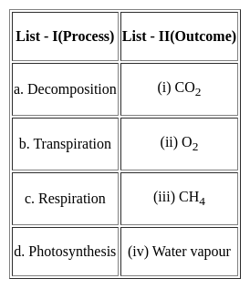
Match List I with List II :


Choose the correct answer from the options given below:

Detailed Solution for Kerala SET Paper 2 Mock Test - 3 (Geography) - Question 27

Correct Answer: ​(A) - (I), (B) - (II), (C) - (III), (D) - (IV).

Key Points


Additional Information

  • Peter Haggett CBE FBA is a British geographer and academic, Professor Emeritus and Senior Research Fellow in Urban and Regional Geography at the School of Geographical Sciences, University of Bristol.
  • Torsten Hägerstrand was a Swedish geographer. He is known for his work on migration, cultural diffusion, and, time geography. A native and resident of Sweden, Hägerstrand was a professor of geography at Lund University, where he received his doctorate in 1953. His doctoral research was on cultural diffusion.
  • Richard John Chorley was an English geographer, and Professor of Geography at Cambridge University, known as the leading figure in quantitative geography in the late 20th century, who played an instrumental role in bringing the use of systems theory to geography.
  • William Wheeler Bunge Jr. was an American geographer active mainly as a quantitative geographer and spatial theorist. He also became a radical geographer and anti-war activist in the US and Canada.
Kerala SET Paper 2 Mock Test - 3 (Geography) - Question 28
Which of the following agro-climatic regions practices shifting agriculture?
Detailed Solution for Kerala SET Paper 2 Mock Test - 3 (Geography) - Question 28

The Eastern Himalayan region has rugged topography, steep slopes, thick forests and swift flowing rivers. The area has red brown soil and has shifting cultivation. It is called jhumming locally. Rice, maize, potato and fruits are the main crops here.

Kerala SET Paper 2 Mock Test - 3 (Geography) - Question 29

The use of microorganism metabolism to remove pollutants such as oil spills in the water bodies is known as :

Detailed Solution for Kerala SET Paper 2 Mock Test - 3 (Geography) - Question 29

Bioremediation is a process used to treat contaminated media, including water, soil and subsurface material, by altering environmental conditions to stimulate growth of microorganisms and degrade the target pollutants.

Kerala SET Paper 2 Mock Test - 3 (Geography) - Question 30
The spreading and merging of places from different cultures including food, clothing, and even languages that people love and enjoy every day is known as -
Detailed Solution for Kerala SET Paper 2 Mock Test - 3 (Geography) - Question 30

Correct Answer: Cultural diffusion.

Key Points 

Cultural diffusion:

  • Cultural diffusion is the spreading out and merging of pieces from different cultures.
  • These different cultures all have many diverse types of food, clothing, and even languages that people love and enjoy every day. 
  • The definition of cultural diffusion is the spread of the beliefs and social activities of one culture to different ethnicities, religions, nationalities, etc.
  • An example of cultural diffusion is the tradition of the German Christmas pickle becoming popular in the United States.

Additional Information 

Convergence culture:

  • Convergence culture is a theory that recognizes changing relationships and experiences with new media. Henry Jenkins is accepted by media academics to be the father of the term with his book Convergence Culture: Where Old and new media collide.

Cultural ecology:

  • Cultural ecology is the study of the adaptation of a culture to a specific environment and how changes in that environment lead to changes in that specific culture.
  • Cultural ecology is the study of human adaptations to social and physical environments.
  • Human adaptation refers to both biological and cultural processes that enable a population to survive and reproduce within a given or changing environment.
  • This may be carried out diachronically, or synchronically.​​

Culture Hearths:

  • Culture Hearths are the centers of origin of ancient civilizations which continue to inspire and influence modern societies of the world today. ​
View more questions
30 tests
Information about Kerala SET Paper 2 Mock Test - 3 (Geography) Page
In this test you can find the Exam questions for Kerala SET Paper 2 Mock Test - 3 (Geography) solved & explained in the simplest way possible. Besides giving Questions and answers for Kerala SET Paper 2 Mock Test - 3 (Geography), EduRev gives you an ample number of Online tests for practice

Top Courses for KTET

Download as PDF

Top Courses for KTET